@EricBlake12 1h
Latest WWB is the strongest of the year- should squash any sig upwelling KW and favors a strong Nino later this yr

Moderator: S2k Moderators


asd123 wrote:What happened to the CDAS SFLUX SST anomaly map? It hasn't updated since 18z Saturday. The map is usually updated 3 or 4 hours after the time z. (ie 3 or 4 hours after 18z)


asd123 wrote:asd123 wrote:What happened to the CDAS SFLUX SST anomaly map? It hasn't updated since 18z Saturday. The map is usually updated 3 or 4 hours after the time z. (ie 3 or 4 hours after 18z)
Those CDAS graphs that show the Nino indices viewtopic.php?f=31&t=92137&start=0 (scroll down the page to find the graphs, not a saved image btw) will not update until that CDAS SFLUX SST anomaly map updates. That map hasn't updated since 18z, Saturday, so we don't know the Nino regions indices until the map updates.

Yellow Evan wrote:NDG wrote:Yellow Evan wrote:
I don't think so. We've been tracking how warm the subsurface is for months. If anything, we slightly overestimated.
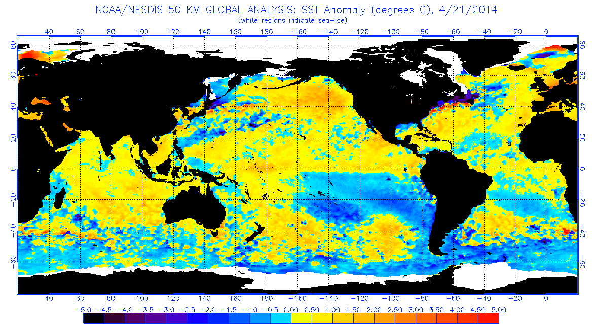
I am not buying the forecast for a moderate to strong typical eastern based El Nino until I start seeing waters along Nino 1+2 & coastal S.A. America really start warming up, they have been persistently cool, and all that cool water south of the Equator (indicative of strong easterly winds still present) is probably cooling a lot of that warm subsurface waters as it surfaces. A lot of you are comparing this event to 97 but if it wants now catch up to that year we better start seeing some warm waters surfacing this week coming up.
http://www.ospo.noaa.gov/data/sst/anoma ... 7.2014.gif
Nino 1+2 has warmed a past week. N above average anomalies are located N of the equator.

dexterlabio wrote:I wanted to ask this weeks ago...do we always have to compare daily indices of this year with that of 1997 to say that we're going towards strong EN? I'd rather see the monthly trend over weekly or daily values. It's impossible IMO to see 2014 copying everything from 1997. It will be unique in its own way.
I think the notable difference so far is that 2014 doesn't resemble an east-based warming but more central-based, due to Nino 1+2 still being negative.. A new WWB could change this, or maybe when NHem spring is over...
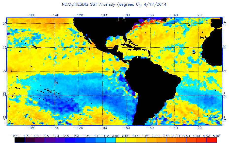
NDG wrote:Yellow Evan wrote:NDG wrote:I am not buying the forecast for a moderate to strong typical eastern based El Nino until I start seeing waters along Nino 1+2 & coastal S.A. America really start warming up, they have been persistently cool, and all that cool water south of the Equator (indicative of strong easterly winds still present) is probably cooling a lot of that warm subsurface waters as it surfaces. A lot of you are comparing this event to 97 but if it wants now catch up to that year we better start seeing some warm waters surfacing this week coming up.
http://www.ospo.noaa.gov/data/sst/anoma ... 7.2014.gif
Nino 1+2 has warmed a past week. N above average anomalies are located N of the equator.
Niño region 1+2 does not go north of the equator.

CaliforniaResident wrote:I know that 30 day SOI is positive but what's the latest trend on the day to day fluctuation? Is it still rising or falling? Is there still the possibility of us hitting El Nino early this summer?
SouthFloridian92 wrote:What is the SOI and how does it affect the El nino/ La Nina cycles?
Yellow Evan wrote:Didn't know that. Thanks for letting me know. It still had warmed in the past week though per http://www.tropicaltidbits.com/analysis/nino12.png


xtyphooncyclonex wrote:Some warming now starting to occur over the coast of Peru (Niño 1+2) as the warm subsurface equatorial anomalies are going nearer towards the surface. The problem now is that the westerlies are too weak and dominated by the easterlies, which does not cooperate in the development of an El Niño.
Ntxw wrote:Officially as of the update (as NDG posted) remains +0.2C.
This coming week is the week it needs to warm over 0.5C if we are to keep pace with 1997.
Caution on using the CDAS sst maps, the CPC uses buoys and not so much satellites to do readings if I'm not mistaken. We've seen the two not agree often so for predictions on updates I would recommend eyeballing using tao/triton
Users browsing this forum: Ulf and 71 guests


