ENSO Updates (2007 thru 2023)

This is the general tropical discussion area. Anyone can take their shot at predicting a storms path.

Moderator: S2k Moderators

Forum rules

The posts in this forum are NOT official forecasts and should not be used as such. They are just the opinion of the poster and may or may not be backed by sound meteorological data. They are NOT endorsed by any professional institution or STORM2K. For official information, please refer to products from the National Hurricane Center and National Weather Service.

Help Support Storm2K
Message
Author
User avatar
cycloneye
Admin
Admin
Posts: 145366
Age: 68
Joined: Thu Oct 10, 2002 10:54 am
Location: San Juan, Puerto Rico

Re:

#4361 Postby cycloneye » Sat May 03, 2014 10:37 am

Ntxw wrote:I can't post the TAO maps from my phone, if someone could. The thermocline is pretty much El Nino, new kelvin wave pushing more warm water into the CPAC regions, the east speaks for itself as cycloneye says. Lots of updates on Monday, IRI should continue to raise odds and first Nino readings at 3.4


Here is the TAO graphic.

Image
0 likes   
Visit the Caribbean-Central America Weather Thread where you can find at first post web cams,radars
and observations from Caribbean basin members Click Here

User avatar
xtyphooncyclonex
Category 5
Category 5
Posts: 3861
Age: 23
Joined: Sat Dec 08, 2012 9:07 am
Location: Cebu City
Contact:

Re:

#4362 Postby xtyphooncyclonex » Sat May 03, 2014 10:45 am

Ntxw wrote:I can't post the TAO maps from my phone, if someone could. The thermocline is pretty much El Nino, new kelvin wave pushing more warm water into the CPAC regions, the east speaks for itself as cycloneye says. Lots of updates on Monday, IRI should continue to raise odds and first Nino readings at 3.4

And the storm many models are in agreement of development, Amanda in the EPac. Not surprised if it will result in a WWB. Niño 3, 3.4 and 4 are VERY NEAR Niño status. Not surprised if all regions gradually warm by next week.
0 likes   
REMINDER: My opinions that I, or any other NON Pro-Met in this forum, are unofficial. Please do not take my opinions as an official forecast and warning. I am NOT a meteorologist. Following my forecasts blindly may lead to false alarm, danger and risk if official forecasts from agencies are ignored.

Webbweather53
Tropical Wave
Tropical Wave
Posts: 1
Joined: Sun Apr 13, 2014 4:17 pm

Re: ENSO Updates

#4363 Postby Webbweather53 » Sat May 03, 2014 10:54 am

Here's a comment I made on an ENSO blog @ weatherunderground in response to another blogger which is worth looking @ in regards to the recent SOI debacle, MJO, & historical precedence in terms of ENSO...

Blogger: "Also, I have a possibly crazy theory on what's happening with the SOI. In the last few frames of this animation, you can see what appears to be a smallish downwelling kelvin wave at the eastern edge of the Indian Ocean.
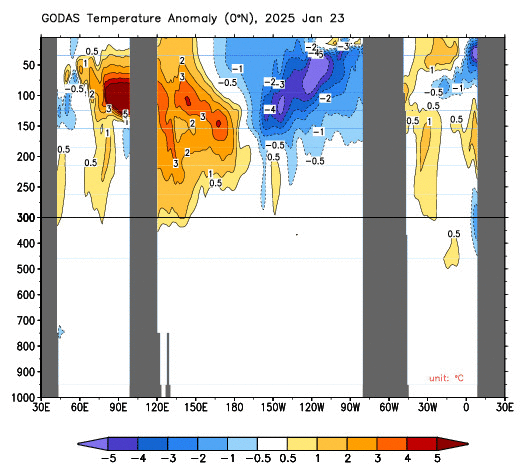
http://www.cpc.ncep.noaa.gov/products/G ... emp.0n.gif
And on these maps you might notice increasing warm anomalies in the waters around central Indonesia/Northern Australia.
http://www.tropicaltidbits.com/analysis ... obal_1.png

http://www.tropicaltidbits.com/analysis ... obal_1.png

This would seem to indicate that the kelvin wave mentioned above is transporting heat from the eastern Indian Ocean to the area just north of Darwin. And with Tahiti being in the Nino 4 region, nowhere near where the much bigger.more instense Pacific kelvin wave is surfacing, it makes sense for the SOI to be increasing, at least until the heating in Nino 1 2 starts to spread westward."


Me: "I agree with this & think that the backside of the MJO pulse initially excited by Equatorial Convectively coupled (Atmospheric) Kelvin Wave activity that emanated from South America & into the eastern Indian Ocean where it triggered an MJO pulse near the end of March.
http://www.bom.gov.au/climate/mjo/graph ... .small.gif

This MJO pulse progressed through the Indian Ocean, & on the backside of the mean convective center, a series of very formidable WWBs likely was the cause for this downwelling Kelvin Wave as the westerly winds that pushed well into the Maritime Continent forced a piling up of water on the western side of the Maritime Continent. Also as you mentioned, this downwelling Kelvin Wave has led to an increase in SST surrounding Australia that is feeding back to an anomalous strong (@ least for preceding El Ninos) +SOI, however the SOI is highly susceptible to local weather, "noise" in the global tropics from (MRG, Eq Rossby, Intertio-Gravity waves. etc) & like another often mentioned oscillation in relation to ENSO (PDO), the SOI tends to lag changes in SST & other conditions associated with ENSO, not necessarily enforce them, although one could argue it does <em>exaggerate</em> them. I've looked into RMM MJO record since 1974 to at least attempt to find some historical precedence for this recent MJO debacle. I focused my attention on the January-June period preceding all first year El Nino events since 1974 that featured a decent amplitude (1.5 sigma or greater) MJO pulse that was able to for the most part, maintain or heighten this amplitude as the MJO pushed through the western Indian Ocean & into the Maritime Continent (Phases 3, 4 AND 5) & continued to withhold from going into the COD before generally reaching the western Pacific (phase 6) region like what has just transpired. What I discovered was that the MJO exhibited this behavior in preceding all El Nino events with exception to the 1982-83 & 1991-92 El Ninos, which I find interesting given these were the two El Nino events that coincided & followed some of the most of the largest volcanic eruptions within the last several decades (El Chichon 1982, Pinatubo 1991) (possibly significant influence on the OLR Principal Component (PC) of the MJO with major volcanic eruptions?).


Furthermore, I organized these events by the month & week in which they occur, & looking @ only events in which this MJO behavior was exhibited before May 1 (reason being, this is the period in which the Pacific is most vulnerable to WWBs, MJO activity, & for many El Ninos, is a crucial time for determining the intensity of the downwelling phase of the Eq KW that can reveal or at least hint @ even several months in advance, the intensity of the oncoming El Nino. Also the propagation speed of an Equatorial Kelvin Wave near 2.5-3 m/s means it typically takes about 3 months or so from the initiation of the disturbance in the western Pacific to the time it surfaces along with the western coast of South America, thus this indicates that if any forcing mechanisms, WWBs, Rossby Waves, etc, need to occur in the several months leading up to the initiation & evolution of an El Nino event, most preferably in spring when the Pacific is most susceptible to such anomalies in behavior.), I noticed something quite interesting...


2nd Week of Apr 1977-78 (Weak El Nino)
<img http://www.bom.gov.au/climate/mjo/graph ... .small.gif

2nd Week of Feb 1994-95 (Weak El Nino)
http://www.bom.gov.au/climate/mjo/graph ... .small.gif

1st Week of Feb 2004-05 (Weak El Nino)
http://www.bom.gov.au/climate/mjo/graph ... .small.gif


2nd Week of Apr 2009-10 (Moderate El Nino)
http://www.bom.gov.au/climate/mjo/graph ... .small.gif

While the sample size in this analysis is small, this implies at least from a historical standpoint that the recent tendencies of the MJO is quite atypical to that of strong El Ninos, in fact, if anything, we are seeing a more analogous pattern to that of weak El Ninos, but this isn't likely to remain this way for long.

Although its certainly not out of the ordinary for the MJO to enter the Indian Ocean, it certainly is discouraged to have strong amplitude in the Maritime Continent. This makes sense given the natural tendency for a progressively weaker Walker Cell in light of an oncoming El Nino. This consequently leads to the convective signal of the MJO to naturally push farther east into the Pacific & drop its spectral peak towards the lower end of the highly variable & "climatological" 30-90 day return period thanks to a decrease in global convective activity that is one of the primary drivers of the MJO's propagation through the global tropics. Hence, its common for the MJO to move much faster, w/ larger variations in amplitude through the tropics preceding El Nino, while the opposite tends to be the case in patterns before La Ninas."
0 likes   

User avatar
cycloneye
Admin
Admin
Posts: 145366
Age: 68
Joined: Thu Oct 10, 2002 10:54 am
Location: San Juan, Puerto Rico

Re: ENSO Updates

#4364 Postby cycloneye » Sat May 03, 2014 10:57 am

:uarrow: Webbweather53,welcome to Storm2k. Don't hesitate to post all the stuff you post in other forums here as they are very helpful to the discussion of the different topics that we have here.
0 likes   
Visit the Caribbean-Central America Weather Thread where you can find at first post web cams,radars
and observations from Caribbean basin members Click Here

User avatar
Ntxw
Storm2k Moderator
Storm2k Moderator
Posts: 22786
Joined: Wed Oct 21, 2009 6:34 pm
Location: DFW, Texas

Re: Re:

#4365 Postby Ntxw » Sat May 03, 2014 11:03 am

xtyphooncyclonex wrote:
Ntxw wrote:I can't post the TAO maps from my phone, if someone could. The thermocline is pretty much El Nino, new kelvin wave pushing more warm water into the CPAC regions, the east speaks for itself as cycloneye says. Lots of updates on Monday, IRI should continue to raise odds and first Nino readings at 3.4

And the storm many models are in agreement of development, Amanda in the EPac. Not surprised if it will result in a WWB. Niño 3, 3.4 and 4 are VERY NEAR Niño status. Not surprised if all regions gradually warm by next week.


I don't think WWB's are too much a signal to watch for now. While they can assist this is mostly important in creating oceanic kelvin waves which have already occured. The Pacific has already switched its currents from east to west, feedback is already in place. Everything will likely be a net result of the state of the equatorial Pacific rather than cause. MJO becomes less of a factor for enso outside of spring into summer.
.
0 likes   
The above post and any post by Ntxw is NOT an official forecast and should not be used as such. It is just the opinion of the poster and may or may not be backed by sound meteorological data. It is NOT endorsed by any professional institution including Storm2k. For official information, please refer to NWS products.

  Help support Storm2K!
Help Support Storm2K

tolakram
Admin
Admin
Posts: 20010
Age: 62
Joined: Sun Aug 27, 2006 8:23 pm
Location: Florence, KY (name is Mark)

Re: ENSO Updates

#4366 Postby tolakram » Sat May 03, 2014 12:05 pm

I look at ninos more as testing theories than relying on indicators. El Nino is showing up, weather patterns are changing or have changed, so what are the indicators showing? Are they still mostly reliable? Looking at the indicators to predict the future has resulted in El Nino cancel posts about once a page here. :D There's still something (or a lot of things) we don't know, IMO. I love watching this stuff.
0 likes   
M a r k
- - - - -
Join us in chat: Storm2K Chatroom Invite. Android and IOS apps also available.

The posts in this forum are NOT official forecasts and should not be used as such. Posts are NOT endorsed by any professional institution or STORM2K.org. For official information and forecasts, please refer to NHC and NWS products.

User avatar
Kingarabian
S2K Supporter
S2K Supporter
Posts: 15981
Joined: Sat Aug 08, 2009 3:06 am
Location: Honolulu, Hawaii

Re: ENSO Updates

#4367 Postby Kingarabian » Sat May 03, 2014 1:49 pm

tolakram wrote:I look at ninos more as testing theories than relying on indicators. El Nino is showing up, weather patterns are changing or have changed, so what are the indicators showing? Are they still mostly reliable? Looking at the indicators to predict the future has resulted in El Nino cancel posts about once a page here. :D There's still something (or a lot of things) we don't know, IMO. I love watching this stuff.

Image
0 likes   
RIP Kobe Bryant

User avatar
Kingarabian
S2K Supporter
S2K Supporter
Posts: 15981
Joined: Sat Aug 08, 2009 3:06 am
Location: Honolulu, Hawaii

#4368 Postby Kingarabian » Sat May 03, 2014 2:14 pm

I think once El-Nino conditions begin cementing themselves, the SOI will eventually follow no matter what's going on near Darwin.

I think if we didn't have a +PDO, +ESPI, and a weak sub-surface pool, only then should we take sudden SOI changes seriously.

As we can all see, the SOI went up sharply but only mediocre cooling ensued. After that, all the Nino regions warmed up. That's because El-Nino has all of its core components going its way (massive sub-surface pool, wet ESPI, very positive PDO).
0 likes   
RIP Kobe Bryant

User avatar
xtyphooncyclonex
Category 5
Category 5
Posts: 3861
Age: 23
Joined: Sat Dec 08, 2012 9:07 am
Location: Cebu City
Contact:

#4369 Postby xtyphooncyclonex » Sat May 03, 2014 9:50 pm

30 day SOI is going down steadily.
0 likes   
REMINDER: My opinions that I, or any other NON Pro-Met in this forum, are unofficial. Please do not take my opinions as an official forecast and warning. I am NOT a meteorologist. Following my forecasts blindly may lead to false alarm, danger and risk if official forecasts from agencies are ignored.

User avatar
xtyphooncyclonex
Category 5
Category 5
Posts: 3861
Age: 23
Joined: Sat Dec 08, 2012 9:07 am
Location: Cebu City
Contact:

#4370 Postby xtyphooncyclonex » Sun May 04, 2014 12:17 am

+3C anomalies are about to reach the surface at Nino 1+2.
0 likes   
REMINDER: My opinions that I, or any other NON Pro-Met in this forum, are unofficial. Please do not take my opinions as an official forecast and warning. I am NOT a meteorologist. Following my forecasts blindly may lead to false alarm, danger and risk if official forecasts from agencies are ignored.

dexterlabio
Category 5
Category 5
Posts: 3468
Joined: Sat Oct 24, 2009 11:50 pm

Re: ENSO Updates

#4371 Postby dexterlabio » Sun May 04, 2014 12:26 am

If no TC activity occurs near Darwin, we can assume 30-day SOI will go down as sharp as it did last March. Or maybe, as Kingarabian said, as this El Nino cements itself the SOI will go down no matter what.
0 likes   
Personal Forecast Disclaimer:
The posts in this forum are NOT official forecast and should not be used as such. They are just the opinion of the poster and may or may not be backed by sound meteorological data. They are NOT endorsed by any professional institution or storm2k.org. For official information, please refer to the NHC and NWS products.

User avatar
xtyphooncyclonex
Category 5
Category 5
Posts: 3861
Age: 23
Joined: Sat Dec 08, 2012 9:07 am
Location: Cebu City
Contact:

Re: ENSO Updates

#4372 Postby xtyphooncyclonex » Sun May 04, 2014 12:34 am

dexterlabio wrote:If no TC activity occurs near Darwin, we can assume 30-day SOI will go down as sharp as it did last March. Or maybe, as Kingarabian said, as this El Nino cements itself the SOI will go down no matter what.

Conditions there are unfavorable for tropical cyclone development. 30-day SOI is really going down, now at +6.8. I will not be surprised if it goes way down till negative. Pressures in Darwin are increasing due to the dry weather.
Last edited by xtyphooncyclonex on Sun May 04, 2014 1:32 am, edited 2 times in total.
0 likes   
REMINDER: My opinions that I, or any other NON Pro-Met in this forum, are unofficial. Please do not take my opinions as an official forecast and warning. I am NOT a meteorologist. Following my forecasts blindly may lead to false alarm, danger and risk if official forecasts from agencies are ignored.

User avatar
xtyphooncyclonex
Category 5
Category 5
Posts: 3861
Age: 23
Joined: Sat Dec 08, 2012 9:07 am
Location: Cebu City
Contact:

#4373 Postby xtyphooncyclonex » Sun May 04, 2014 12:39 am

Daily Nino regions SSTs [Rounded off]
1+2: +0.5C
3: +0.5C
3.4: +0.4C
4: +0.4C

Warmth from 1+2 is spreading towards other Nino regions. Eastern based El Nino should be happening this year. With these, we should have the El Nino officially declared by the CPC by late June or early July.
0 likes   
REMINDER: My opinions that I, or any other NON Pro-Met in this forum, are unofficial. Please do not take my opinions as an official forecast and warning. I am NOT a meteorologist. Following my forecasts blindly may lead to false alarm, danger and risk if official forecasts from agencies are ignored.

stormkite
S2K Supporter
S2K Supporter
Posts: 672
Joined: Fri Sep 13, 2013 3:59 am

Re: ENSO Updates

#4374 Postby stormkite » Sun May 04, 2014 1:14 am

xtyphooncyclonex wrote:
dexterlabio wrote:If no TC activity occurs near Darwin, we can assume 30-day SOI will go down as sharp as it did last March. Or maybe, as Kingarabian said, as this El Nino cements itself the SOI will go down no matter what.

Conditions there are unfavorable for tropical cyclone development. 30-day SOI is really going down, now at +6.8. I will not be surprised if it goes way down till negative.


We are officially now in the dry season there is just 30c dry air across the TopEnd cyclone season is over.
0 likes   

User avatar
Ntxw
Storm2k Moderator
Storm2k Moderator
Posts: 22786
Joined: Wed Oct 21, 2009 6:34 pm
Location: DFW, Texas

#4375 Postby Ntxw » Sun May 04, 2014 10:20 am

Water is pushing again in the west. This pretty much locks it all in this fall and early winter as we saw the first push take 3-4 months. The next one will make it's notice (if you go by that time span) in Sept/Oct which is when El Nino's/La Nina's begin to peak.

Image
0 likes   
The above post and any post by Ntxw is NOT an official forecast and should not be used as such. It is just the opinion of the poster and may or may not be backed by sound meteorological data. It is NOT endorsed by any professional institution including Storm2k. For official information, please refer to NWS products.


  Help support Storm2K!

Help Support Storm2K


User avatar
xtyphooncyclonex
Category 5
Category 5
Posts: 3861
Age: 23
Joined: Sat Dec 08, 2012 9:07 am
Location: Cebu City
Contact:

Re: ENSO Updates

#4376 Postby xtyphooncyclonex » Sun May 04, 2014 11:48 am

In the second image, are those westerlies? They could be helping in the massive warming right now.
Image
0 likes   
REMINDER: My opinions that I, or any other NON Pro-Met in this forum, are unofficial. Please do not take my opinions as an official forecast and warning. I am NOT a meteorologist. Following my forecasts blindly may lead to false alarm, danger and risk if official forecasts from agencies are ignored.

User avatar
NDG
S2K Supporter
S2K Supporter
Posts: 15446
Joined: Sun Jul 09, 2006 10:14 pm
Location: Orlando, FL

Re: ENSO Updates

#4377 Postby NDG » Sun May 04, 2014 1:08 pm

xtyphooncyclonex wrote:In the second image, are those westerlies? They could be helping in the massive warming right now.
http://imagizer.imageshack.us/a/img843/5973/mznm.gif


Somebody can correct me but I believe those are not westerlies, they are weaker than normal easterly tarde winds in the central and western Pacific.
0 likes   

User avatar
cycloneye
Admin
Admin
Posts: 145366
Age: 68
Joined: Thu Oct 10, 2002 10:54 am
Location: San Juan, Puerto Rico

Re: ENSO Updates

#4378 Postby cycloneye » Sun May 04, 2014 7:25 pm

And it continues the downward trend of the past few days. (+5.8)

http://www.bom.gov.au/climate/enso/soi.txt
0 likes   
Visit the Caribbean-Central America Weather Thread where you can find at first post web cams,radars
and observations from Caribbean basin members Click Here

User avatar
Ntxw
Storm2k Moderator
Storm2k Moderator
Posts: 22786
Joined: Wed Oct 21, 2009 6:34 pm
Location: DFW, Texas

#4379 Postby Ntxw » Mon May 05, 2014 6:54 am

Well it looks like we aren't getting our first >+0.5C in today's update. Graph and index both show staying at 0.4C, all the other regions have warmed to above except for 3.4
0 likes   
The above post and any post by Ntxw is NOT an official forecast and should not be used as such. It is just the opinion of the poster and may or may not be backed by sound meteorological data. It is NOT endorsed by any professional institution including Storm2k. For official information, please refer to NWS products.


  Help support Storm2K!

Help Support Storm2K


User avatar
xtyphooncyclonex
Category 5
Category 5
Posts: 3861
Age: 23
Joined: Sat Dec 08, 2012 9:07 am
Location: Cebu City
Contact:

Re: ENSO Updates

#4380 Postby xtyphooncyclonex » Mon May 05, 2014 7:42 am

Update: Massive warming at Nino 1+2
Last week:
Nino 1+2
0.1
Nino 3
0.4
Nino 3.4
0.4
Nino 4
0.6

This week:
Nino 1+2
0.8
Nino 3
0.5
Nino 3.4
0.4
Nino 4
0.7

SOURCE: http://www.cpc.ncep.noaa.gov/data/indices/wksst8110.for
Basis for CPC updates on SSTs

We are ahead of other El Nino years but 1997. Could this be the second strongest since 1990?
Average SST at roughly the same update was at moderate
1.0

Average SST at a more-or-less [roughly] the same date [few days BEFORE update] according to the source above.
4-30-2014: Weak Nino threshold
0.6
could become Strong Eastern

2009: Warm Neutral threshold
0.1
became [previously] Weak-to-Moderate Eastern transitioned to Strong Modoki

2006: Weak Nina threshold
-0.6
became Weak-to-Moderate Eastern

2004: Cool Neutral threshold
-0.1
became Weak Modoki

2002: Warm Neutral threshold borderline Nino
0.4
became Moderate Modoki

1994: Cool Neutral
-0.3
became Moderate-to-Strong Modoki

1991: Warm Neutral
0.2
became Strong Modoki
0 likes   
REMINDER: My opinions that I, or any other NON Pro-Met in this forum, are unofficial. Please do not take my opinions as an official forecast and warning. I am NOT a meteorologist. Following my forecasts blindly may lead to false alarm, danger and risk if official forecasts from agencies are ignored.


Return to “Talkin' Tropics”

Who is online

Users browsing this forum: ElectricStorm, Stratton23, USTropics and 47 guests