ENSO Updates (2007 thru 2023)

This is the general tropical discussion area. Anyone can take their shot at predicting a storms path.

Moderator: S2k Moderators

Forum rules

The posts in this forum are NOT official forecasts and should not be used as such. They are just the opinion of the poster and may or may not be backed by sound meteorological data. They are NOT endorsed by any professional institution or STORM2K. For official information, please refer to products from the National Hurricane Center and National Weather Service.

Help Support Storm2K
Message
Author
User avatar
NDG
S2K Supporter
S2K Supporter
Posts: 15446
Joined: Sun Jul 09, 2006 10:14 pm
Location: Orlando, FL

Re: ENSO Updates

#4381 Postby NDG » Mon May 05, 2014 9:57 am

The problem that I see for Nino 3.4 still averaging below El Nino threshold is that there is still a lot of cooler than average waters south of the equator pushing close to Nino 3.4 zone, which goes from the latitude of 5N down to 5S, where some of the cooler than average waters still are.
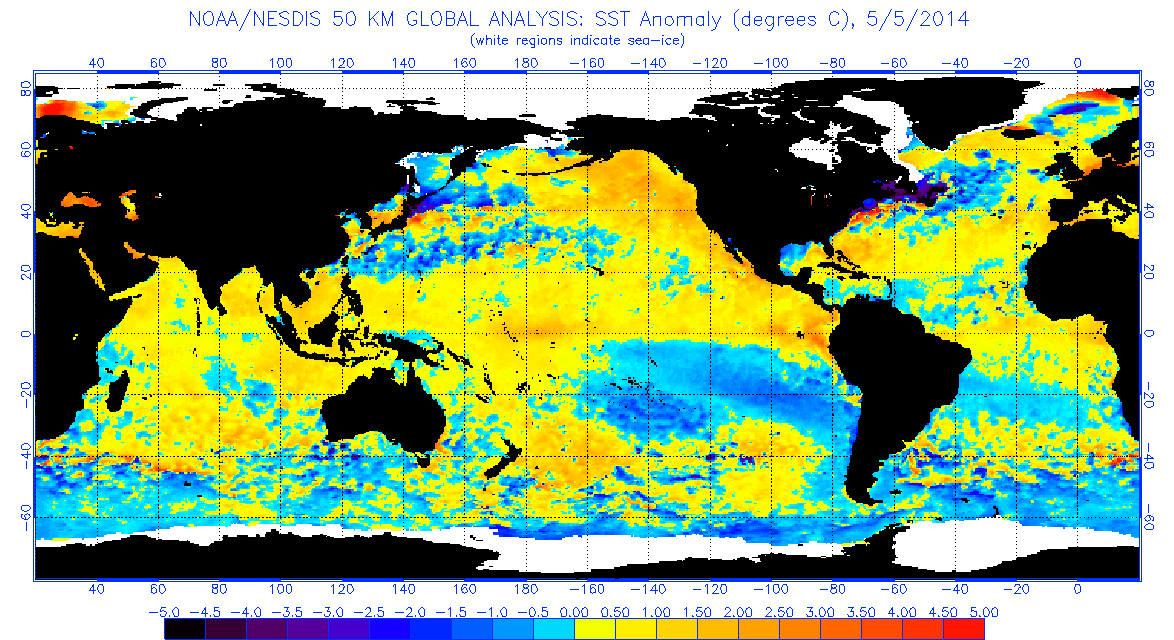
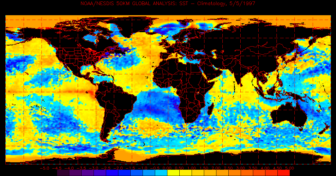
Back in '97 there wasn't that much cooler waters south of the equator in the Pacific.

Image
Image
0 likes   

User avatar
cycloneye
Admin
Admin
Posts: 145366
Age: 68
Joined: Thu Oct 10, 2002 10:54 am
Location: San Juan, Puerto Rico

Re: ENSO Updates

#4382 Postby cycloneye » Mon May 05, 2014 10:21 am

Here is the text of the CPC weekly update. Nino 3.4 remains at +0.4C while Nino 1+2 is up to +0.8C.

http://www.cpc.ncep.noaa.gov/products/a ... ts-web.pdf
0 likes   
Visit the Caribbean-Central America Weather Thread where you can find at first post web cams,radars
and observations from Caribbean basin members Click Here

User avatar
xtyphooncyclonex
Category 5
Category 5
Posts: 3861
Age: 23
Joined: Sat Dec 08, 2012 9:07 am
Location: Cebu City
Contact:

Re: ENSO Updates

#4383 Postby xtyphooncyclonex » Mon May 05, 2014 10:35 am

cycloneye wrote:Here is the text of the CPC weekly update. Nino 3.4 remains at +0.4C while Nino 1+2 is up to +0.8C.

http://www.cpc.ncep.noaa.gov/products/a ... ts-web.pdf

That is really big warming in 1+2. Some +3C's appearing in the weekly SSTs by CPC/NOAA.
0 likes   
REMINDER: My opinions that I, or any other NON Pro-Met in this forum, are unofficial. Please do not take my opinions as an official forecast and warning. I am NOT a meteorologist. Following my forecasts blindly may lead to false alarm, danger and risk if official forecasts from agencies are ignored.

User avatar
cycloneye
Admin
Admin
Posts: 145366
Age: 68
Joined: Thu Oct 10, 2002 10:54 am
Location: San Juan, Puerto Rico

Re: ENSO: CPC 5/5/14: Nino 1+2=+0.8C / Nino 3.4 =+0.4C

#4384 Postby cycloneye » Mon May 05, 2014 4:29 pm

Plenty of warm water moving in Pacific.

Image
0 likes   
Visit the Caribbean-Central America Weather Thread where you can find at first post web cams,radars
and observations from Caribbean basin members Click Here

User avatar
xtyphooncyclonex
Category 5
Category 5
Posts: 3861
Age: 23
Joined: Sat Dec 08, 2012 9:07 am
Location: Cebu City
Contact:

#4385 Postby xtyphooncyclonex » Mon May 05, 2014 9:51 pm

ONI last FMA was -0.5 in the latest CPC update. It probably was because of the cold anomalies we saw last February to early March.

Well, because of the major rapid warming that occurred in late March to the present, we may see our ONI rapidly increase by MAM. Probably, our ONI would reach 0.5 [Nino threshold] by AMJ, making AMJ the first tri-monthly period of El Nino conditions.

NOT MENTIONED [seen in TAO graphic]
In terms of trade winds, there are some weakening easterlies over the Central and Eastern Pacific, and there are westerlies starting over the far Western Pacific. This is also seen in the movement of warm waters over the IDL eastward toward the Eastern Pacific, which is due to the westerlies.

DISCLAIMER

The posts in this forum are NOT official forecast and should not be used as such. They are just the opinion of the poster and may or may not be backed by sound meteorological data. They are NOT endorsed by any professional institution or storm2k.org. For official information, please refer to the NOAA/CPC and BOM products.
0 likes   
REMINDER: My opinions that I, or any other NON Pro-Met in this forum, are unofficial. Please do not take my opinions as an official forecast and warning. I am NOT a meteorologist. Following my forecasts blindly may lead to false alarm, danger and risk if official forecasts from agencies are ignored.

User avatar
xtyphooncyclonex
Category 5
Category 5
Posts: 3861
Age: 23
Joined: Sat Dec 08, 2012 9:07 am
Location: Cebu City
Contact:

#4386 Postby xtyphooncyclonex » Tue May 06, 2014 5:57 am

All ENSO regions now at El Nino threshold!

Nino 1+2: +0.7C
Nino 3: +0.5C
Nino 3.4: +0.5C
Nino 4: +0.7C

Average SST: +0.6C!!!!
0 likes   
REMINDER: My opinions that I, or any other NON Pro-Met in this forum, are unofficial. Please do not take my opinions as an official forecast and warning. I am NOT a meteorologist. Following my forecasts blindly may lead to false alarm, danger and risk if official forecasts from agencies are ignored.

User avatar
cycloneye
Admin
Admin
Posts: 145366
Age: 68
Joined: Thu Oct 10, 2002 10:54 am
Location: San Juan, Puerto Rico

Re: ENSO Updates

#4387 Postby cycloneye » Tue May 06, 2014 6:09 am

The SOI is going down fast.

SOI values for 06 May 2014


Average for last 30 days
2.8

Average for last 90 days
-4.2

Daily contribution to SOI calculation
-35.8

http://www.longpaddock.qld.gov.au/seaso ... tionindex/

0 likes   
Visit the Caribbean-Central America Weather Thread where you can find at first post web cams,radars
and observations from Caribbean basin members Click Here

User avatar
xtyphooncyclonex
Category 5
Category 5
Posts: 3861
Age: 23
Joined: Sat Dec 08, 2012 9:07 am
Location: Cebu City
Contact:

Re: ENSO Updates

#4388 Postby xtyphooncyclonex » Tue May 06, 2014 7:27 am

cycloneye wrote:The SOI is going down fast.

SOI values for 06 May 2014


Average for last 30 days
2.8

Average for last 90 days
-4.2

Daily contribution to SOI calculation
-35.8

http://www.longpaddock.qld.gov.au/seaso ... tionindex/


Very fast!
0 likes   
REMINDER: My opinions that I, or any other NON Pro-Met in this forum, are unofficial. Please do not take my opinions as an official forecast and warning. I am NOT a meteorologist. Following my forecasts blindly may lead to false alarm, danger and risk if official forecasts from agencies are ignored.

User avatar
Ntxw
Storm2k Moderator
Storm2k Moderator
Posts: 22786
Joined: Wed Oct 21, 2009 6:34 pm
Location: DFW, Texas

Re: ENSO Updates

#4389 Postby Ntxw » Tue May 06, 2014 7:39 am

xtyphooncyclonex wrote:Very fast!


It will fall even faster. We lose big positives, even if we gain little negatives. Tahiti's pressures didn't fall too much, it's Darwin's big rise that gave the big daily -SOI's.

ESPI continues it's rise and is at +1.67
0 likes   
The above post and any post by Ntxw is NOT an official forecast and should not be used as such. It is just the opinion of the poster and may or may not be backed by sound meteorological data. It is NOT endorsed by any professional institution including Storm2k. For official information, please refer to NWS products.

  Help support Storm2K!
Help Support Storm2K

User avatar
xtyphooncyclonex
Category 5
Category 5
Posts: 3861
Age: 23
Joined: Sat Dec 08, 2012 9:07 am
Location: Cebu City
Contact:

Re: ENSO Updates

#4390 Postby xtyphooncyclonex » Tue May 06, 2014 7:43 am

Ntxw wrote:
xtyphooncyclonex wrote:Very fast!


It will fall even faster. We lose big positives, even if we gain little negatives. Tahiti's pressures didn't fall too much, it's Darwin's big rise that gave the big daily -SOI's.

ESPI continues it's rise and is at +1.67

And, Darwin usually gets high pressures during El Nino events. Yep it should fall very very rapidly towards El Nino threshold of -8.
0 likes   
REMINDER: My opinions that I, or any other NON Pro-Met in this forum, are unofficial. Please do not take my opinions as an official forecast and warning. I am NOT a meteorologist. Following my forecasts blindly may lead to false alarm, danger and risk if official forecasts from agencies are ignored.

User avatar
xtyphooncyclonex
Category 5
Category 5
Posts: 3861
Age: 23
Joined: Sat Dec 08, 2012 9:07 am
Location: Cebu City
Contact:

#4391 Postby xtyphooncyclonex » Tue May 06, 2014 7:46 am

With these conditions, El Nino should be declared in June by the CPC. AMJ would be the first tri-monthly period with an ONI of 0.5.
0 likes   
REMINDER: My opinions that I, or any other NON Pro-Met in this forum, are unofficial. Please do not take my opinions as an official forecast and warning. I am NOT a meteorologist. Following my forecasts blindly may lead to false alarm, danger and risk if official forecasts from agencies are ignored.

User avatar
xtyphooncyclonex
Category 5
Category 5
Posts: 3861
Age: 23
Joined: Sat Dec 08, 2012 9:07 am
Location: Cebu City
Contact:

#4392 Postby xtyphooncyclonex » Tue May 06, 2014 7:48 am

WE should see El Nino threshold on Nino 3.4 by next week. Daily anomalies are increasing in that region. The equatorial warm waters over the IDL are moving eastwards.
0 likes   
REMINDER: My opinions that I, or any other NON Pro-Met in this forum, are unofficial. Please do not take my opinions as an official forecast and warning. I am NOT a meteorologist. Following my forecasts blindly may lead to false alarm, danger and risk if official forecasts from agencies are ignored.

User avatar
Ntxw
Storm2k Moderator
Storm2k Moderator
Posts: 22786
Joined: Wed Oct 21, 2009 6:34 pm
Location: DFW, Texas

#4393 Postby Ntxw » Tue May 06, 2014 9:42 am

4C anomalies have reappeared in the CPAC below the surface meaning warm waters continue to push from the west. The Equatorial Pacific thermocline has about flattened out with warmth typical with El Nino's. As in a post before, this new push only solidifies the idea we will feed the Nino well into fall. These oceanic kelvin waves are doing the job slowly.
0 likes   
The above post and any post by Ntxw is NOT an official forecast and should not be used as such. It is just the opinion of the poster and may or may not be backed by sound meteorological data. It is NOT endorsed by any professional institution including Storm2k. For official information, please refer to NWS products.


  Help support Storm2K!

Help Support Storm2K


User avatar
Hammy
Category 5
Category 5
Posts: 5849
Age: 41
Joined: Fri May 25, 2012 5:25 pm
Contact:

Re: ENSO Updates

#4394 Postby Hammy » Tue May 06, 2014 3:44 pm

Looks like for the first time all four Nino regions are above the +0.5 mark for the daily values.
0 likes   
The above post is not official and should not be used as such. It is the opinion of the poster and may or may not be backed by sound meteorological data. It is not endorsed by any professional institution or storm2k.org. For official information, please refer to the NHC and NWS products.

User avatar
xtyphooncyclonex
Category 5
Category 5
Posts: 3861
Age: 23
Joined: Sat Dec 08, 2012 9:07 am
Location: Cebu City
Contact:

#4395 Postby xtyphooncyclonex » Tue May 06, 2014 9:57 pm

Massive warming in Niño 4 and 1+2.
0 likes   
REMINDER: My opinions that I, or any other NON Pro-Met in this forum, are unofficial. Please do not take my opinions as an official forecast and warning. I am NOT a meteorologist. Following my forecasts blindly may lead to false alarm, danger and risk if official forecasts from agencies are ignored.

stormkite
S2K Supporter
S2K Supporter
Posts: 672
Joined: Fri Sep 13, 2013 3:59 am

#4396 Postby stormkite » Tue May 06, 2014 10:03 pm

Palm oil industry in the Philippines will be decimated again.
0 likes   

User avatar
Ntxw
Storm2k Moderator
Storm2k Moderator
Posts: 22786
Joined: Wed Oct 21, 2009 6:34 pm
Location: DFW, Texas

#4397 Postby Ntxw » Tue May 06, 2014 10:18 pm

I have no idea how Australia does their ENSO system but it seems from the latest update they have come out with a new ENSO status warning method? I'm guessing Alert is a precursor to their version of a warning.

http://www.bom.gov.au/climate/enso/tracker/

"...The El Niño–Southern Oscillation (ENSO) Tracker status is at El Niño ALERT level, meaning that there is at least a 70% chance of an El Niño occurring in 2014"

And here's the latest daily map of sst anomalies

Image

Aside from the equatorial Pacific warming, the PDO region of the north Pacific remains in configuration of positive for yet another month (warm east, cold west) and not just weak but quite a bit, which likely will be reflected soon in the next update of the value.
0 likes   
The above post and any post by Ntxw is NOT an official forecast and should not be used as such. It is just the opinion of the poster and may or may not be backed by sound meteorological data. It is NOT endorsed by any professional institution including Storm2k. For official information, please refer to NWS products.


  Help support Storm2K!

Help Support Storm2K


User avatar
xtyphooncyclonex
Category 5
Category 5
Posts: 3861
Age: 23
Joined: Sat Dec 08, 2012 9:07 am
Location: Cebu City
Contact:

Re:

#4398 Postby xtyphooncyclonex » Tue May 06, 2014 10:29 pm

stormkite wrote:Palm oil industry in the Philippines will be decimated again.

Yep. Our farms are starting to do bad. I hope the effects here are not that bad as 1997.
0 likes   
REMINDER: My opinions that I, or any other NON Pro-Met in this forum, are unofficial. Please do not take my opinions as an official forecast and warning. I am NOT a meteorologist. Following my forecasts blindly may lead to false alarm, danger and risk if official forecasts from agencies are ignored.

User avatar
xtyphooncyclonex
Category 5
Category 5
Posts: 3861
Age: 23
Joined: Sat Dec 08, 2012 9:07 am
Location: Cebu City
Contact:

Re:

#4399 Postby xtyphooncyclonex » Tue May 06, 2014 10:40 pm

Ntxw wrote:I have no idea how Australia does their ENSO system but it seems from the latest update they have come out with a new ENSO status warning method? I'm guessing Alert is a precursor to their version of a warning.

http://www.bom.gov.au/climate/enso/tracker/

"...The El Niño–Southern Oscillation (ENSO) Tracker status is at El Niño ALERT level, meaning that there is at least a 70% chance of an El Niño occurring in 2014"

And here's the latest daily map of sst anomalies

Image

Aside from the equatorial Pacific warming, the PDO region of the north Pacific remains in configuration of positive for yet another month (warm east, cold west) and not just weak but quite a bit, which likely will be reflected soon in the next update of the value.

The CPAC warming will merge with the SA warming the the CPAC waters will move eastward if the system in the EPAC will successfully develop and become a tropical storm.
0 likes   
REMINDER: My opinions that I, or any other NON Pro-Met in this forum, are unofficial. Please do not take my opinions as an official forecast and warning. I am NOT a meteorologist. Following my forecasts blindly may lead to false alarm, danger and risk if official forecasts from agencies are ignored.

User avatar
cycloneye
Admin
Admin
Posts: 145366
Age: 68
Joined: Thu Oct 10, 2002 10:54 am
Location: San Juan, Puerto Rico

Re: ENSO Updates

#4400 Postby cycloneye » Wed May 07, 2014 4:49 am

BoM issues a El Nino Alert

Tropical Pacific continues to warm; El Niño likely in 2014

Issued on Tuesday 6 May 2014 | Product Code IDCKGEWWOO

The tropical Pacific Ocean has warmed steadily in recent months, with large warm anomalies in the ocean sub-surface (5-day values up to +6 °C) and increasingly warm sea surface temperatures. Climate models surveyed by the Bureau suggest El Niño development is possible as early as July. These factors indicate that while El Niño in 2014 cannot be guaranteed, the likelihood of an event developing remains at least 70% and we are at El Niño ALERT level.

For El Niño to be established and maintained, coupling needs to occur between the tropical Pacific atmosphere and ocean, evident by further and persistent weakening of the trade winds and a consistent increase in cloudiness near the Date Line. These atmospheric characteristics of El Niño are forecast to become evident over the coming months.

El Niño impacts climate across much of the world, including below average rainfall in the western Pacific and Indonesian regions, and increased rainfall in the central and eastern Pacific. For Australia, El Niño is usually associated with below average rainfall over southern and eastern inland Australia, with about two thirds of El Niño events since 1900 resulting in major drought over large parts of the continent.

The Indian Ocean Dipole (IOD) is currently in a neutral state. Model outlooks suggest the IOD is likely to remain neutral through late autumn and early winter, with two of the five models surveyed suggesting a positive IOD may develop by early spring. Positive IOD events often coincide with El Niño and are typically associated with large parts of southern and central Australia experiencing lower rainfall than usual.

http://www.bom.gov.au/climate/enso/#tabs=Overview

0 likes   
Visit the Caribbean-Central America Weather Thread where you can find at first post web cams,radars
and observations from Caribbean basin members Click Here


Return to “Talkin' Tropics”

Who is online

Users browsing this forum: ElectricStorm, Stratton23, USTropics and 47 guests