2017 indicators: SST's / MSLP / SAL / Steering / Instability
Moderator: S2k Moderators
Forum rules

The posts in this forum are NOT official forecasts and should not be used as such. They are just the opinion of the poster and may or may not be backed by sound meteorological data. They are NOT endorsed by any professional institution or STORM2K. For official information, please refer to products from the National Hurricane Center and National Weather Service.
-
TheStormExpert
Re: 2017 indicators: SST's / MSLP / SAL / Steering / Instability
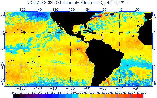
Some of the big Gulf seasons like 2005 for instance had a cooler than average Gulf in the spring. Regardless of how cool it is now it should be fully open for business with the next two months, only things that remain to be seen is where shear levels and instability are at by that time.
0 likes
-
SFLcane

- S2K Supporter

- Posts: 10281
- Age: 48
- Joined: Sat Jun 05, 2010 1:44 pm
- Location: Lake Worth Florida
Re: 2017 indicators: SST's / MSLP / SAL / Steering / Instability
Phil calling for near normal season tommorow just spoke to him. I don't agree with that. Cooler waters to the north heat focused in the tropics not as past couple yrs were heat was in sub tropics. If nothing changes in my view setup screams active season but we shall see.
0 likes
-
weathaguyry

- Category 5

- Posts: 1273
- Age: 22
- Joined: Wed Jun 15, 2016 5:16 am
- Location: Long Island, NY
Re: 2017 indicators: SST's / MSLP / SAL / Steering / Instability
SFLcane wrote:Phil calling for near normal season tommorow just spoke to him. I don't agree with that. Cooler waters to the north heat focused in the tropics not as past couple yrs were heat was in sub tropics. If nothing changes in my view setup screams active season but we shall see.
I agree, it will be interesting to see the reasoning that he gives for a near normal season, as there is essentially nothing against an active season, except the argument that we may sneak out a very weak Nino during the peak of the season, which is looking very unlikely at this time
0 likes
My posts are only my opinions and NOT official forecasts. For official forecasts, consult the National Hurricane Center or the National Weather Service.
Irene 11', Sandy 12', Fay 20’, Isaias 20’, Elsa 21’, Henri 21’, Ida 21’
Irene 11', Sandy 12', Fay 20’, Isaias 20’, Elsa 21’, Henri 21’, Ida 21’
-
TheStormExpert
Re: 2017 indicators: SST's / MSLP / SAL / Steering / Instability
weathaguyry wrote:SFLcane wrote:Phil calling for near normal season tommorow just spoke to him. I don't agree with that. Cooler waters to the north heat focused in the tropics not as past couple yrs were heat was in sub tropics. If nothing changes in my view setup screams active season but we shall see.
I agree, it will be interesting to see the reasoning that he gives for a near normal season, as there is essentially nothing against an active season, except the argument that we may sneak out a very weak Nino during the peak of the season, which is looking very unlikely at this time
Well that's an increase from his slightly below normal season prediction back on April 6th I suppose. You also have to remember that CSU and Phil K. have been on the conservative side for seasonal predictions for a few years now. Like they say, all it takes is one and last season Matthew was almost that one here in Florida. Can't say if we or will not be as lucky this season, time will tell!
1 likes
-
SFLcane
- S2K Supporter
- Posts: 10281
- Age: 48
- Joined: Sat Jun 05, 2010 1:44 pm
- Location: Lake Worth Florida
Re: 2017 indicators: SST's / MSLP / SAL / Steering / Instability
CSU playing it safe I guess tricky forecast for sure. BUT just can't ignore current configuration across the basin looks great if you wanna see some real bonified majors i.e. Gorgeous, Ivan. Should be fun.
0 likes
-
TheStormExpert
Re: 2017 indicators: SST's / MSLP / SAL / Steering / Instability
SFLcane wrote:CSU playing it safe I guess tricky forecast for sure. BUT just can't ignore current configuration across the basin looks great if you wanna see some real bonified majors i.e. Gorgeous, Ivan. Should be fun.
I sure miss those days. By the way, do you have any idea on what his numbers might be?
0 likes
-
CrazyC83
- Professional-Met

- Posts: 34315
- Joined: Tue Mar 07, 2006 11:57 pm
- Location: Deep South, for the first time!
Re: 2017 indicators: SST's / MSLP / SAL / Steering / Instability
Kingarabian wrote:EPS weeklies showing a wet, cooler CONUS through July.
Reminiscent of 2004 or 2009 in a sense. Of course, those had completely different outcomes...
0 likes
-
tolakram
- Admin

- Posts: 20178
- Age: 62
- Joined: Sun Aug 27, 2006 8:23 pm
- Location: Florence, KY (name is Mark)
Re: 2017 indicators: SST's / MSLP / SAL / Steering / Instability
I've been reading about 2006, the infamous dud season, and things we may want to look for in relation to this season. Something to discuss perhaps.
1. 2017 el nino strength is still a big unknown IMO. Probably weak?
2. 2006 featured a rapidly forming moderate El Niño event, the presence of the Saharan Air Layer over the tropical Atlantic, and the steady presence of a robust secondary high-pressure area to the Azores high centered on Bermuda. (wikipedia article references Klotzbach, Philip J.; Gray, William M. review), The big question is which of these was most important, or did it take all 3 to impact the season?
3. Atlantic SST's look favorable for development, as they did in 2006, but other conditions seem to be as important if no more so.
What should we be looking for early on to tell us how this season will proceed?
0 likes
M a r k
- - - - -
Join us in chat: Storm2K Chatroom Invite. Android and IOS apps also available.
The posts in this forum are NOT official forecasts and should not be used as such. Posts are NOT endorsed by any professional institution or STORM2K.org. For official information and forecasts, please refer to NHC and NWS products.
-
weathaguyry
- Category 5
- Posts: 1273
- Age: 22
- Joined: Wed Jun 15, 2016 5:16 am
- Location: Long Island, NY
Re: 2017 indicators: SST's / MSLP / SAL / Steering / Instability
2017 has a very obvious positive tripole, but 2006 had no signal. And also I believe the sub-surface warm pool in the Nino regions was very robust.
0 likes
My posts are only my opinions and NOT official forecasts. For official forecasts, consult the National Hurricane Center or the National Weather Service.
Irene 11', Sandy 12', Fay 20’, Isaias 20’, Elsa 21’, Henri 21’, Ida 21’
Irene 11', Sandy 12', Fay 20’, Isaias 20’, Elsa 21’, Henri 21’, Ida 21’
-
wxman57

- Moderator-Pro Met

- Posts: 23172
- Age: 68
- Joined: Sat Jun 21, 2003 8:06 pm
- Location: Houston, TX (southwest)
Re: 2017 indicators: SST's / MSLP / SAL / Steering / Instability
SFLcane wrote:Phil calling for near normal season tomorrow just spoke to him. I don't agree with that. Cooler waters to the north heat focused in the tropics not as past couple yrs were heat was in sub tropics. If nothing changes in my view setup screams active season but we shall see.
I've been talking to Phil over the past month. I know his numbers but won't make them public until he does in a few days. Note that near-normal doesn't mean the same as normal (12/6/2).
0 likes
-
cycloneye

- Admin
- Posts: 149275
- Age: 69
- Joined: Thu Oct 10, 2002 10:54 am
- Location: San Juan, Puerto Rico
Re: 2017 indicators: SST's / MSLP / SAL / Steering / Instability
0 likes
Visit the Caribbean-Central America Weather Thread where you can find at first post web cams,radars
and observations from Caribbean basin members Click Here
and observations from Caribbean basin members Click Here
-
TheStormExpert
Re: 2017 indicators: SST's / MSLP / SAL / Steering / Instability
wxman57 wrote:SFLcane wrote:Phil calling for near normal season tomorrow just spoke to him. I don't agree with that. Cooler waters to the north heat focused in the tropics not as past couple yrs were heat was in sub tropics. If nothing changes in my view setup screams active season but we shall see.
I've been talking to Phil over the past month. I know his numbers but won't make them public until he does in a few days. Note that near-normal doesn't mean the same as normal (12/6/2).
Hey wxman57, what's your predictions or thoughts on the 2017 Atlantic season I'm interested in hearing.
1 likes

Re: 2017 indicators: SST's / MSLP / SAL / Steering / Instability
Atlantic's MDR continues to warm up as long as the NAO does not go way back up to positive.
0 likes
-
WeatherEmperor
- S2K Supporter
- Posts: 4806
- Age: 42
- Joined: Thu Sep 04, 2003 2:54 pm
- Location: South Florida
Re: 2017 indicators: SST's / MSLP / SAL / Steering / Instability
@pro mets,
Did the June 1st Euro SLP forecast maps (paid version) for ASO come out today? If so can you give us an idea if it shows higher or lower SLP for the MDR?
Sent from my iPhone 7 using Tapatalk
Did the June 1st Euro SLP forecast maps (paid version) for ASO come out today? If so can you give us an idea if it shows higher or lower SLP for the MDR?
Sent from my iPhone 7 using Tapatalk
0 likes
Re: 2017 indicators: SST's / MSLP / SAL / Steering / Instability
Despite the Atlantic MDR SST warmth, I'm banking on a weak El Niño or just underneath that to make conditions more hostile than last season's weak La Niña. I based my prediction of 9/5/2 on how most weak to low end moderate El Niño seasons have gone since the satellite era started (1960's) and this includes some years with a warm MDR.
Three of the last 4 weak El Niño seasons, all during the current +AMO, had 8/6/2 (2014), 9/5/2 (2006), and 12/4/2 (2002). Before that, 1994 had 7/3/0, 1986 had 6/4/0, 1979 had 9/5/2, 1977 had 6/5/1, 1976 had 10/6/2, 1968 had 8/4/0, and 1963 had 9/7/2. There were two notable very active exceptions, 2004 and 1969. So, 10 of the last 12 weak to low end moderate Niño seasons had fairly near or weaker than my prediction. So, that's the background research I used to predict 9/5/2. It is by no means wish-casting for a not strong season in case anyone might be wondering. Of course, it would be helpful to this prediction if we can actually get a weak to low end moderate El Niño. Then again, 9/5/2 isn't exactly a weak season...it is below average but not really weak.
Three of the last 4 weak El Niño seasons, all during the current +AMO, had 8/6/2 (2014), 9/5/2 (2006), and 12/4/2 (2002). Before that, 1994 had 7/3/0, 1986 had 6/4/0, 1979 had 9/5/2, 1977 had 6/5/1, 1976 had 10/6/2, 1968 had 8/4/0, and 1963 had 9/7/2. There were two notable very active exceptions, 2004 and 1969. So, 10 of the last 12 weak to low end moderate Niño seasons had fairly near or weaker than my prediction. So, that's the background research I used to predict 9/5/2. It is by no means wish-casting for a not strong season in case anyone might be wondering. Of course, it would be helpful to this prediction if we can actually get a weak to low end moderate El Niño. Then again, 9/5/2 isn't exactly a weak season...it is below average but not really weak.
1 likes
Personal Forecast Disclaimer:
The posts in this forum are NOT official forecasts and should not be used as such. They are just the opinion of the poster and may or may not be backed by sound meteorological data. They are NOT endorsed by any professional institution or storm2k.org. For official information, please refer to the NHC and NWS products.
The posts in this forum are NOT official forecasts and should not be used as such. They are just the opinion of the poster and may or may not be backed by sound meteorological data. They are NOT endorsed by any professional institution or storm2k.org. For official information, please refer to the NHC and NWS products.
-
TheStormExpert
Re: 2017 indicators: SST's / MSLP / SAL / Steering / Instability
Tropical Tidbits own Levi Cowan and his 2017 Atlantic Hurricane Season Outlook.
http://www.tropicaltidbits.com/blog/2017/06/02/outlook-for-the-2017-atlantic-hurricane-season/
Link: https://youtu.be/H3FxehVzRAc
http://www.tropicaltidbits.com/blog/2017/06/02/outlook-for-the-2017-atlantic-hurricane-season/
Link: https://youtu.be/H3FxehVzRAc
2 likes

Re: 2017 indicators: SST's / MSLP / SAL / Steering / Instability
tolakram wrote:I've been reading about 2006, the infamous dud season, and things we may want to look for in relation to this season. Something to discuss perhaps.
1. 2017 el nino strength is still a big unknown IMO. Probably weak?
2. 2006 featured a rapidly forming moderate El Niño event, the presence of the Saharan Air Layer over the tropical Atlantic, and the steady presence of a robust secondary high-pressure area to the Azores high centered on Bermuda. (wikipedia article references Klotzbach, Philip J.; Gray, William M. review), The big question is which of these was most important, or did it take all 3 to impact the season?
3. Atlantic SST's look favorable for development, as they did in 2006, but other conditions seem to be as important if no more so.
What should we be looking for early on to tell us how this season will proceed?
Good question. Each of us tend to look at certain indicators more than others and I suppose the key is how do we (as a science) properly weigh the appropriate value to those factors that have the greatest influence on this season. Of course, that IS the $1 Million Dollar Question, right? Even still, I think that one need break down the question into two parts. What should we be looking at to tell us how this season will proceed..... 1) in terms of "conditions favorable vs. unfavorable for cyclogenesis" AND, 2) in terms of "Geographic location of development and track". Furthermore, I suppose there is yet another aspect where the former ultimately impacts the latter lol. Meaning, if one takes 1981 as an example most would agree that this was an average to somewhat busy year (if one were to include tropical depressions - 18). It would seem appropriate to suggest that conditions in the MDR were marginally conducive for development, yet a sweet spot for development seemed to exist between 18N -25N across the basin. I remember that year because 1981 broke my own personal record for greatest distances I've ever kayaked through urban streets and neighborhoods lol (thanks to T.S. Dennis in S. Florida). Given the overall mid level troughing throughout the W. Atlantic that year, most storms re-curved well East of the US. Would a more conducive MDR that year perhaps resulted in an even greater number of E. Atlantic tropical cyclones to have developed? One could easily speculate that in theory, this would have further increased the number of "wide right" conveyor belt of storm tracks that year. Now, lets take that line of thinking a bit further by suggesting the possibility that if a greater number of ITCZ disturbances were to have developed further East, might the result have been fewer robust ITCZ disturbances to eventually make their way into the W. Atlantic and Caribbean? Would Florida have ever received 20 plus inches of rain from Dennis had that particular pocket formed into a tropical cyclone much further east (and south) that year? Just an interesting thought process to consider when one thinks about how not only "favorable/unfavorable conditions" having a huge impact on the potential for any given area to be affected by severe conditions .... based on the quality and number of storms that form, but also how suppressed or very favorable areas of development might have very profound and even inverse implications impacting other areas of the Atlantic altogether.
When it comes down to it, at first blush I'd say that a family in Brownsville Texas, New Orleans, Tampa, N.C. Outer Banks (and especially the entire Caribbean), is at greater risk during those years having 18 or more named storms, as opposed to years with 10 or less named storm. That's just common sense based on increased risk with an increase in potential events. I think most people are generally apt to first consider those conditions that will cause a season to be under or over active, and then use that analogy to generally interpret that result as an indication of whether they might be at a potentially greater or lessor risk that year. So, if I were to have to pick one single signal that might signal a sign as to what kind of year this may be, I'd guess it should be "instability", especially after witnessing the huge impact that suppressed mid or upper level conditions (i.e. Saharan Air Layer) can absolutely have on whether cyclogenesis or overall more intense storms might occur that year. On the other hand, if one were to look at the question slightly different and as, "What should we be looking for early on to tell us how this season will proceed.... AND impact each of us", then one need look at things a bit differently. If I were to live along the Texas or Louisiana coast, I'd want to know "how" might I be at a greater risk as a result of a suppressed Atlantic hurricane season? What level of risk could there be if there is a more active hurricane season? I think those factors need to be carefully considered just as I speculated whether Florida might have escaped the wrath of Dennis in '81 had the MDR been more conducive for development that year. Ultimately, that answer must take into account what impact that an overall steering pattern (as well as conditions that might help shear apart a storm or allow it to rapidly intensify) would have "if" a tropical cyclone were allowed to reach or develop in the Western or Northern Gulf. Because we don't typically see a massive shotgun appearance of 25 plus Hurricane landfalls that seemingly are random and impacting the Virgin Islands, Central America, the W. Gulf, Florida and the entire Eastern U.S., its eventually obvious that the general setup for that particular hurricane season ultimately causes certain parts of the basin to be more under the gun than others for any particular year. For myself, this is more of the manner in which I personally try and anticipate "what" or "how" the upcoming year might end up looking like, as a result of various surface, mid and upper air conditions, as well as taking into account large global ENSO and other large scale factors. Sure, I think everyone need keep in mind the "you never know", or that at any given season one random "Hurricane Andrew event" could somehow impact any number of coastal regions. More importantly though, I think its important to consider the implications how over-active and under-active basin wide activity, those anticipated areas where we might think will be where tropical cyclones will largely form that year, and other subtle circumstances might on the surface cause our collective initial perspective to paint a broad view regarding what type of hurricane season we're apt to have. The problem is that this over-generalizes the type of season that most may anticipate. A more realistic approach might be a more specific analysis how distinct regions throughout the basin might be impacted as a result of the data that we presently look at more broadly while looking at our hazy crystal ball.
Whether hobbyist or professional we are all curious or even enjoy the banter each year regarding the broader topic of how the upcoming Atlantic hurricane season might turn out. Maybe the more appropriate question as it applies to each unique region and to our respective latitude and longitudes is "How might presently observed climate and atmospheric conditions, large scale circulations, long wave patterns, and even smaller scale regional observations ultimately cause an enhanced risk to any one particular area, not solely as a result of broadly favorable basin-wide cyclogenesis conditions... but even as a result of less favorable basin-wide conditions that could present some downstream impact perhaps affecting how early and where tropical cyclone might then form as a result. Basically, I'm more curious about how we can somehow glean greater insight from the massive archive of past year data to better anticipate what factors suggest how one 14/10/3 Atlantic Hurricane Season might be broadly forecast as potentially uneventful and largely benign, while still offering insight to those particular regions that might anticipate an enhanced risk in spite of a more low-key year. Hopefully this breakthrough would just as easily provide us distinct insight so that when a different 14/10/3 year such as 1998 comes along, such advanced insight might result in far fewer deaths and damage that were the result of Bonnie, Earl, Georges, and especially Mitch during that particularly deadly 1998 hurricane season.
All in all thats how I tend to look at just how bad and what type of season that I think we might see It sure will be impressive when the science actually exists to far better anticipate and even forecast years where greater risk exists for major hurricane development, as well as forecast which regional areas are at greatest risk for that upcoming season.
2 likes
Andy D
(For official information, please refer to the NHC and NWS products.)
(For official information, please refer to the NHC and NWS products.)
-
TheStormExpert
Re: 2017 indicators: SST's / MSLP / SAL / Steering / Instability
Watch the Gulf of Mexico for possible tropical cyclone development over the next few weeks if conditions improve.
https://twitter.com/TropicalTidbits/status/870651976249475072
https://twitter.com/TropicalTidbits/status/870652591025389569
https://twitter.com/TropicalTidbits/status/870651976249475072
https://twitter.com/TropicalTidbits/status/870652591025389569
0 likes
-
TheStormExpert
Re: 2017 indicators: SST's / MSLP / SAL / Steering / Instability
Here we are on the second official day of the 2017 Atlantic Hurricane Season so let's take a look at environmental conditions in each sub basin.
Gulf of Mexico:
Wind Shear

Vertical Instability

Caribbean:
Wind Shear

Vertical Instability

Tropical Atlantic:
Wind Shear

Vertical Instability

East Coast:
Wind Shear

Vertical Instability

Subtropical Atlantic:
Wind Shear

Vertical Instability

Overall things look quite favorable especially when you compare it to the East Pacific which has extremely low vertical instability for this time of year. What really stands out is the Tropical Atlantic finally having near normal vertical instability for the first time in many years! Might be in for quite the season especially in the MDR if things remain or get better. The only thing I'm concerned about which could also cause 2017 to be another dead season like 2013 is that warm blob off the NE U.S. coastline, if that expands than all bets are almost off on an above average season. We shall see what happens, but I'm leaning towards an active season right now with 16/8/4.
Gulf of Mexico:
Wind Shear
Vertical Instability
Caribbean:
Wind Shear
Vertical Instability
Tropical Atlantic:
Wind Shear
Vertical Instability
East Coast:
Wind Shear
Vertical Instability
Subtropical Atlantic:
Wind Shear
Vertical Instability
Overall things look quite favorable especially when you compare it to the East Pacific which has extremely low vertical instability for this time of year. What really stands out is the Tropical Atlantic finally having near normal vertical instability for the first time in many years! Might be in for quite the season especially in the MDR if things remain or get better. The only thing I'm concerned about which could also cause 2017 to be another dead season like 2013 is that warm blob off the NE U.S. coastline, if that expands than all bets are almost off on an above average season. We shall see what happens, but I'm leaning towards an active season right now with 16/8/4.
0 likes

Re: 2017 indicators: SST's / MSLP / SAL / Steering / Instability
Atlantic instability looks like it's about to level off again and go below normal.
0 likes
The above post is not official and should not be used as such. It is the opinion of the poster and may or may not be backed by sound meteorological data. It is not endorsed by any professional institution or storm2k.org. For official information, please refer to the NHC and NWS products.
Who is online
Users browsing this forum: Iceresistance and 124 guests