Possible development in the Western Atlantic / GOM (Is Invest 97L)
Moderator: S2k Moderators
Forum rules

The posts in this forum are NOT official forecasts and should not be used as such. They are just the opinion of the poster and may or may not be backed by sound meteorological data. They are NOT endorsed by any professional institution or STORM2K. For official information, please refer to products from the National Hurricane Center and National Weather Service.
-
Stratton23
- Category 5

- Posts: 3574
- Joined: Fri Jul 21, 2023 10:59 pm
- Location: Katy, Tx
Re: Possible development in the Western Atlantic (0/60)
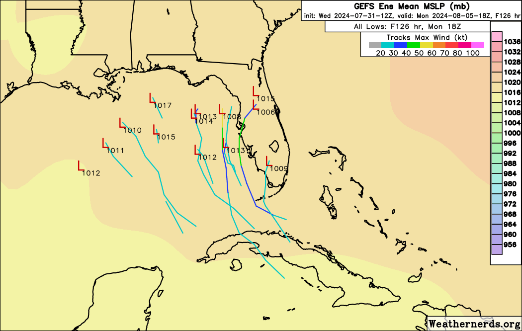
12z GEFS ensembles support a stall, with some looping over the NE gulf and then going up the east coast , and then some stalling, going back south and then turning west towards lousiana and even texas lol
Last edited by Stratton23 on Wed Jul 31, 2024 12:07 pm, edited 1 time in total.
0 likes

Re: Possible development in the Western Atlantic (0/60)
SFLcane wrote:https://i.postimg.cc/T2kHr28m/bnbnb.gif
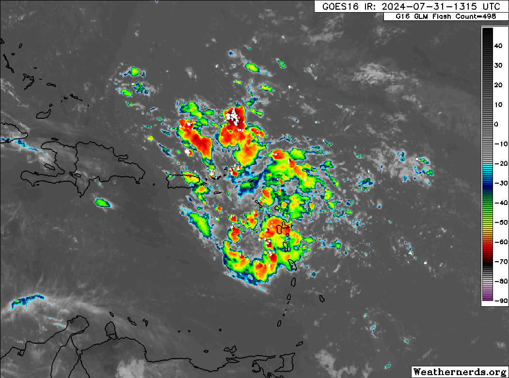
One thing that the Euro has been correct with days ago, this TW start blooming with convection as soon as it started approaching the Lesser Antilles while the GFS took some time to adjust.
2 likes
Re: Possible development in the Western Atlantic (0/60)
wxman57 wrote:GFS remains the only model that predicts a closed low center in the Gulf. It's 12z run looks quite odd. Let's hope something like that doesn't materialize. I'm still thinking east of Florida is more likely.
Not odd at all if indeed tracks further west and the shortwave trough leaves it behind then getting influenced by the building ridge coming across the central US.
0 likes

Re: Possible development in the Western Atlantic (0/60)
Here's an Irony. Typically, the Greater Antilles are what often disrupt existing or developing storms and influence their tracks often protecting Florida. Presently, these same islands might just be the hinderance to earlier development possibly resulting in a significant impact to Florida or the N. GOM coastline.
4 likes
Andy D
(For official information, please refer to the NHC and NWS products.)
(For official information, please refer to the NHC and NWS products.)

-
cycloneye

- Admin

- Posts: 149703
- Age: 69
- Joined: Thu Oct 10, 2002 10:54 am
- Location: San Juan, Puerto Rico
Re: Possible development in the Western Atlantic (0/60)
0 likes
Visit the Caribbean-Central America Weather Thread where you can find at first post web cams,radars
and observations from Caribbean basin members Click Here
and observations from Caribbean basin members Click Here
Re: Possible development in the Western Atlantic (0/60)
Stratton23 wrote:12z GEFS ensembles support a stall, with some looping over the NE gulf and then going up the east coast , and then some stalling, going back south and then turning west towards lousiana and even texas lol
Wow, that would be really wild, I know it has happened before, at least the loop around and back through again behavior, but I haven't
seen it before since I've been following this stuff!!
0 likes
-
TomballEd
- Category 5
- Posts: 1318
- Age: 62
- Joined: Wed Aug 16, 2023 4:52 pm
- Location: Spring/Klein area, not Tomball
Re: Possible development in the Western Atlantic (0/60)
Emmett_Brown wrote:A lot of social media posts mentioning land interaction hindering development, or "breaking up the disturbance". Usually however, it is the land interaction that can act as a focusing mechanism to disturb the structure of the large envelop and focus it. Someone mentioned similarities to Elena; I am getting similar vibes. Elena formed from an African wave hindered by SAL. The wave crossed the big Greater Antilles islands, and a depression formed near the western tip of Cuba, and actually strengthened into a TS while over Cuba. Where the low level center actually forms is really a toss up, so the next couple of days are going to be interesting to watch.
TS Dorian moving through the L. Antilles had an MLC well N of the LLC. One of the islands disrupted the LLC enough that a new LLC could develop below the MLC, and Dorian strengthen rapidly. If the MLC and LLC had been competing to be the primary center, intensification would have been delayed.
0 likes
-
toad strangler

- S2K Supporter

- Posts: 4546
- Joined: Sun Jul 28, 2013 3:09 pm
- Location: Earth
- Contact:
Re: Possible development in the Western Atlantic (0/60)
12z Euro seems to being a 12z GFS'ish stall in nearly the same area as the GFS. Very weak though. Then floats S across the central FL peninsula and out into the Atlantic where it strengthens moving NE
0 likes
My Weather Station
https://www.wunderground.com/dashboard/pws/KFLPORTS603
https://www.wunderground.com/dashboard/pws/KFLPORTS603
-
weeniepatrol

- Category 5
- Posts: 1345
- Joined: Sat Aug 22, 2020 5:30 pm
- Location: WA State
-
MEANINGLESS_NUMBERS
- Category 2

- Posts: 503
- Joined: Mon Nov 02, 2020 1:43 pm
Re: Possible development in the Western Atlantic (0/60)
There continues to be some model support for my preferred wishcast: the wave splutters on without significant development and nothing much comes from this at all.
0 likes
Emily '87, Felix '95, Gert '99, Fabian '03, Humberto '19, Paulette '20, Teddy '20, Fiona '22, Lee '23, Ernesto '24, Humberto/Imelda '25
-
toad strangler
- S2K Supporter
- Posts: 4546
- Joined: Sun Jul 28, 2013 3:09 pm
- Location: Earth
- Contact:
Re: Possible development in the Western Atlantic (0/60)
That's 4 plus days of tropical rains for much of the Florida peninsula on the 12z GFS and the 12z Euro
1 likes
My Weather Station
https://www.wunderground.com/dashboard/pws/KFLPORTS603
https://www.wunderground.com/dashboard/pws/KFLPORTS603

Re: Possible development in the Western Atlantic (0/60)
MEANINGLESS_NUMBERS wrote:There continues to be some model support for my preferred wishcast: the wave splutters on without significant development and nothing much comes from this at all.
If the wave energy tracks directly up the spine of Florida and stalls over land rather than near the coast or offshore, that is still a distinct possibility.
0 likes
Kendall -> SLO -> PBC
Memorable Storms: Katrina (for its Florida landfall...) Wilma Matthew Irma
Memorable Storms: Katrina (for its Florida landfall...) Wilma Matthew Irma
-
Stratton23
- Category 5
- Posts: 3574
- Joined: Fri Jul 21, 2023 10:59 pm
- Location: Katy, Tx
Re: Possible development in the Western Atlantic (0/60)
And to no ones surprise, the euro caves to the GFS, showing a stall in the NE gulf now
1 likes
-
SouthFLTropics

- Category 5
- Posts: 4258
- Age: 50
- Joined: Thu Aug 14, 2003 8:04 am
- Location: Port St. Lucie, Florida
Re: Possible development in the Western Atlantic (0/60)
With all of the scenarios that the models keep throwing out, I sure do hope this gets tagged soon. It will be nice to start seeing the hurricane model output to see what they are thinking.
5 likes
Fourth Generation Florida Native
Personal Storm History: David 79, Andrew 92, Erin 95, Floyd 99, Irene 99, Frances 04, Jeanne 04, Wilma 05, Matthew 16, Irma 17, Ian 22, Nicole 22, Milton 24
Personal Storm History: David 79, Andrew 92, Erin 95, Floyd 99, Irene 99, Frances 04, Jeanne 04, Wilma 05, Matthew 16, Irma 17, Ian 22, Nicole 22, Milton 24
-
cycloneye
- Admin
- Posts: 149703
- Age: 69
- Joined: Thu Oct 10, 2002 10:54 am
- Location: San Juan, Puerto Rico
Re: Possible development in the Western Atlantic (0/60)
SFLcane wrote:Copy and paste NHC 2PM TWO.
Tropical Weather Outlook
NWS National Hurricane Center Miami FL
200 PM EDT Wed Jul 31 2024
For the North Atlantic...Caribbean Sea and the Gulf of Mexico:
Near the Greater Antilles and the Bahamas:
A large tropical wave located over the Lesser Antilles continues to
produce a broad area of disorganized showers and thunderstorms.
While development in the short-term is not anticipated as the system
moves over portions of the Greater Antilles, environmental
conditions are forecast to gradually become more conducive for
development as the system moves generally west-northwestward towards
the Bahamas and Cuba. A tropical depression could form this weekend
or early next week when the system is in the vicinity of the Greater
Antilles, Bahamas, or near Florida. Interests in the Greater
Antilles, the Bahamas, and the southeastern U.S. should monitor the
progress of this system.
* Formation chance through 48 hours...low...near 0 percent.
* Formation chance through 7 days...medium...60 percent.
$$
Forecaster Papin/Landsea
0 likes
Visit the Caribbean-Central America Weather Thread where you can find at first post web cams,radars
and observations from Caribbean basin members Click Here
and observations from Caribbean basin members Click Here
Re: Possible development in the Western Atlantic (0/60)
Latest Euro caving to GFS big time with a weak 1011 low in the southern/SE GOM off the NW end of Cuba. Interesting.
0 likes
-
wzrgirl1

- S2K Supporter
- Posts: 1360
- Joined: Sat Sep 04, 2004 6:44 am
- Location: Pembroke Pines, Florida
Re: Possible development in the Western Atlantic (0/60)
cycloneye wrote:SFLcane wrote:Copy and paste NHC 2PM TWO.Tropical Weather Outlook
NWS National Hurricane Center Miami FL
200 PM EDT Wed Jul 31 2024
For the North Atlantic...Caribbean Sea and the Gulf of Mexico:
Near the Greater Antilles and the Bahamas:
A large tropical wave located over the Lesser Antilles continues to
produce a broad area of disorganized showers and thunderstorms.
While development in the short-term is not anticipated as the system
moves over portions of the Greater Antilles, environmental
conditions are forecast to gradually become more conducive for
development as the system moves generally west-northwestward towards
the Bahamas and Cuba. A tropical depression could form this weekend
or early next week when the system is in the vicinity of the Greater
Antilles, Bahamas, or near Florida. Interests in the Greater
Antilles, the Bahamas, and the southeastern U.S. should monitor the
progress of this system.
* Formation chance through 48 hours...low...near 0 percent.
* Formation chance through 7 days...medium...60 percent.
$$
Forecaster Papin/Landsea
Has the "development cone" changed since this morning?
0 likes
Re: Possible development in the Western Atlantic (0/60)
Is there any model that doesn’t at least get into the Gulf now? Euro, GFS, ICON, UKMET, CMC, and JMA all do with at least GFS, UKMET, and latest available JMA never going back into the Atlantic. Today’s 12Z JMA past 72 hours still not out yet.
1 likes
Personal Forecast Disclaimer:
The posts in this forum are NOT official forecasts and should not be used as such. They are just the opinion of the poster and may or may not be backed by sound meteorological data. They are NOT endorsed by any professional institution or storm2k.org. For official information, please refer to the NHC and NWS products.
The posts in this forum are NOT official forecasts and should not be used as such. They are just the opinion of the poster and may or may not be backed by sound meteorological data. They are NOT endorsed by any professional institution or storm2k.org. For official information, please refer to the NHC and NWS products.
Who is online
Users browsing this forum: Iceresistance, Ulf, WaveBreaking and 218 guests