2021 Indicators: SST's / SAL / MSLP / Shear / Steering / Instability / Sat Images

This is the general tropical discussion area. Anyone can take their shot at predicting a storms path.

Moderator: S2k Moderators

Forum rules

The posts in this forum are NOT official forecasts and should not be used as such. They are just the opinion of the poster and may or may not be backed by sound meteorological data. They are NOT endorsed by any professional institution or STORM2K. For official information, please refer to products from the National Hurricane Center and National Weather Service.

Help Support Storm2K
Message
Author
User avatar
cycloneye
Admin
Admin
Posts: 145294
Age: 68
Joined: Thu Oct 10, 2002 10:54 am
Location: San Juan, Puerto Rico

Re: 2021 Indicators: SST's / SAL / MSLP / Shear / Steering / Instability / Sat Images

#461 Postby cycloneye » Sat May 15, 2021 8:26 pm

DorkyMcDorkface wrote:Appears we're getting another period of weak trades in the Atlantic MDR in a few days. The last period was ineffective in boosting SSTs, so we'll need to see if this upcoming spell will help warm things up before the official start of the hurricane season.
https://i.ibb.co/QHMXVm2/gfs-15-N-hov-u ... 1518-1.png


How much it warms is the question because right now is well below the positive line and it has to go up bigtime to achieve that.

Image

Image
0 likes   
Visit the Caribbean-Central America Weather Thread where you can find at first post web cams,radars
and observations from Caribbean basin members Click Here

Shell Mound
Category 5
Category 5
Posts: 2434
Age: 32
Joined: Thu Sep 07, 2017 3:39 pm
Location: St. Petersburg, FL → Scandinavia

Re: 2021 Indicators: SST's / SAL / MSLP / Shear / Steering / Instability / Sat Images

#462 Postby Shell Mound » Sun May 16, 2021 8:32 am

0 likes   
CVW / MiamiensisWx / Shell Mound
The posts in this forum are NOT official forecasts and should not be used as such. They are just the opinion of the poster and may or may not be backed by sound meteorological data. They are NOT endorsed by any professional institution or STORM2K. For official information, please refer to products from the NHC and NWS.

User avatar
Iceresistance
Category 5
Category 5
Posts: 9288
Age: 21
Joined: Sat Oct 10, 2020 9:45 am
Location: Tecumseh, OK/Norman, OK

Re: 2021 Indicators: SST's / SAL / MSLP / Shear / Steering / Instability / Sat Images

#463 Postby Iceresistance » Sun May 16, 2021 10:37 am

Mid-May Global SST Anomalies in the Atlantic Basin . . .

Image

The MDR is below normal, But I've seen it below normal here before & then it rapidly gets hotter in JJA . . .
0 likes   
Bill 2015 & Beta 2020

Winter 2020-2021 :cold:

All observations are in Tecumseh, OK unless otherwise noted.

Winter posts are focused mainly for Oklahoma & Texas.

Take any of my forecasts with a grain of salt, refer to the NWS, SPC, and NHC for official information

Never say Never with weather! Because ANYTHING is possible!

User avatar
Kazmit
Category 5
Category 5
Posts: 2124
Age: 22
Joined: Mon Jul 25, 2016 8:49 am
Location: Williamsburg, VA / Bermuda

Re: 2021 Indicators: SST's / SAL / MSLP / Shear / Steering / Instability / Sat Images

#464 Postby Kazmit » Sun May 16, 2021 10:55 am

Iceresistance wrote:Mid-May Global SST Anomalies in the Atlantic Basin . . .

https://s3.gifyu.com/images/crw_ssta_natl5c508c45b1f5fb64.png

The MDR is below normal, But I've seen it below normal here before & then it rapidly gets hotter in JJA . . .

That is such an interesting signature with that dark red in a completely straight line pointing from the Bahamas to Spain.
0 likes   
Igor 2010, Sandy 2012, Fay 2014, Gonzalo 2014, Joaquin 2015, Nicole 2016, Humberto 2019

I am only a tropical weather enthusiast. My predictions are not official and may or may not be backed by sound meteorological data. For official information, please refer to the NHC and NWS products.

User avatar
Category5Kaiju
Category 5
Category 5
Posts: 4095
Joined: Thu Dec 24, 2020 12:45 pm
Location: Seattle

Re: 2021 Indicators: SST's / SAL / MSLP / Shear / Steering / Instability / Sat Images

#465 Postby Category5Kaiju » Sun May 16, 2021 11:00 am

To be honest, I cannot recall a recent year in mind when that kind of signature was evident in May. Still imho I find it very hard to believe that the MDR will not warm up in the summer months, but if I had to place a bet I would think this profile would still call for a fairly active year
0 likes   
Unless explicitly stated, all info in my posts is based on my own opinions and observations. Tropical storms and hurricanes can be extremely dangerous. Do not think you can beat Mother Nature. Refer to an accredited weather research agency or meteorologist if you need to make serious decisions regarding an approaching storm.

User avatar
cycloneye
Admin
Admin
Posts: 145294
Age: 68
Joined: Thu Oct 10, 2002 10:54 am
Location: San Juan, Puerto Rico

Re: 2021 Indicators: SST's / SAL / MSLP / Shear / Steering / Instability / Sat Images

#466 Postby cycloneye » Sun May 16, 2021 3:03 pm

0 likes   
Visit the Caribbean-Central America Weather Thread where you can find at first post web cams,radars
and observations from Caribbean basin members Click Here

User avatar
aspen
Category 5
Category 5
Posts: 8818
Joined: Sat Oct 12, 2019 7:10 pm
Location: Connecticut, USA

Re: 2021 Indicators: SST's / SAL / MSLP / Shear / Steering / Instability / Sat Images

#467 Postby aspen » Sun May 16, 2021 4:07 pm

Iceresistance wrote:Mid-May Global SST Anomalies in the Atlantic Basin . . .

https://s3.gifyu.com/images/crw_ssta_natl5c508c45b1f5fb64.png

The MDR is below normal, But I've seen it below normal here before & then it rapidly gets hotter in JJA . . .

This is just so odd. Phil and others have been saying the MDR should warm up, but the warmer subtropic band and the cooler MDR have only been further amplified. If this doesn’t change quick enough, increased stability will become an issue for TCG, and SSTs won’t be quite high enough to support some long-tracking majors. They won’t be cold by ASO, but they won’t be capable of supporting something like Irma, followed by Jose, followed by Maria in 2017.

2021 is starting to look a little less like a MDR year than previously anticipated, which would be good for the islands if that turns out to be the case.
0 likes   
Irene '11 Sandy '12 Hermine '16 5/15/2018 Derecho Fay '20 Isaias '20 Elsa '21 Henri '21 Ida '21

I am only a meteorology enthusiast who knows a decent amount about tropical cyclones. Look to the professional mets, the NHC, or your local weather office for the best information.

User avatar
Category5Kaiju
Category 5
Category 5
Posts: 4095
Joined: Thu Dec 24, 2020 12:45 pm
Location: Seattle

Re: 2021 Indicators: SST's / SAL / MSLP / Shear / Steering / Instability / Sat Images

#468 Postby Category5Kaiju » Sun May 16, 2021 5:02 pm

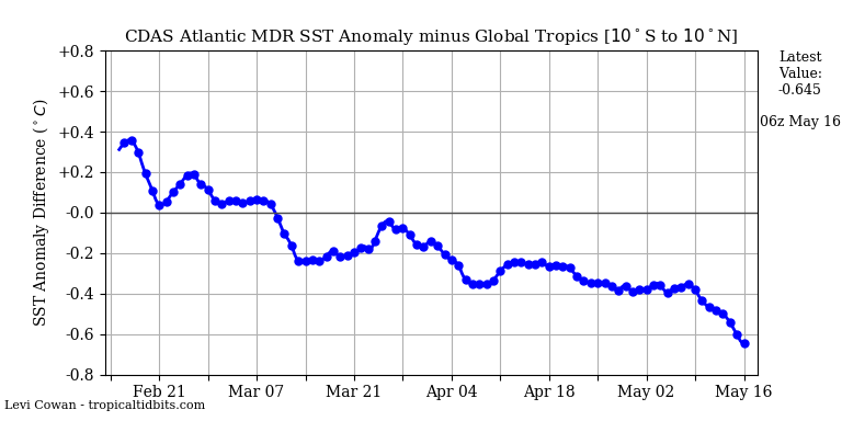
To put this "sst anomalies being cool" buzz into some perspective, the most recent year when cool MDR anomalies actually stuck around in ASO was 2014. That year was a warm neutral/weak El Nino year as well, and even years like dead 2013 and 2009 to an extent did experience warming in the MDR by ASO. I have mentioned this before, but I would be quite surprised and confused to see this cool MDR actually persist in ASO; that would certainly cause me to deeply question the dynamics of tropical activity in the Atlantic.

It is also very interesting to note that the subtropics are way above average but the Atlantic Nino 3 (the equatorial and below like near the Gulf of Guinea) region is also above average. It's only the MDR with cool anomalies that is wedged in between the much warmer subtropics to the north and the equator/Gulf of Guinea to the south. I still am not quite sure why the MDR is cool though, dust? Stronger than normal trades?
2 likes   
Unless explicitly stated, all info in my posts is based on my own opinions and observations. Tropical storms and hurricanes can be extremely dangerous. Do not think you can beat Mother Nature. Refer to an accredited weather research agency or meteorologist if you need to make serious decisions regarding an approaching storm.

User avatar
toad strangler
S2K Supporter
S2K Supporter
Posts: 4543
Joined: Sun Jul 28, 2013 3:09 pm
Location: Earth
Contact:

Re: 2021 Indicators: SST's / SAL / MSLP / Shear / Steering / Instability / Sat Images

#469 Postby toad strangler » Sun May 16, 2021 5:24 pm

aspen wrote:
Iceresistance wrote:Mid-May Global SST Anomalies in the Atlantic Basin . . .

https://s3.gifyu.com/images/crw_ssta_natl5c508c45b1f5fb64.png

The MDR is below normal, But I've seen it below normal here before & then it rapidly gets hotter in JJA . . .

This is just so odd. Phil and others have been saying the MDR should warm up, but the warmer subtropic band and the cooler MDR have only been further amplified. If this doesn’t change quick enough, increased stability will become an issue for TCG, and SSTs won’t be quite high enough to support some long-tracking majors. They won’t be cold by ASO, but they won’t be capable of supporting something like Irma, followed by Jose, followed by Maria in 2017.

2021 is starting to look a little less like a MDR year than previously anticipated, which would be good for the islands if that turns out to be the case.


meh, last year had long track signature written all over it. Didn't happen. Too many eggs are laid in the MDR SST basket.
0 likes   

User avatar
Category5Kaiju
Category 5
Category 5
Posts: 4095
Joined: Thu Dec 24, 2020 12:45 pm
Location: Seattle

Re: 2021 Indicators: SST's / SAL / MSLP / Shear / Steering / Instability / Sat Images

#470 Postby Category5Kaiju » Sun May 16, 2021 5:38 pm

toad strangler wrote:
aspen wrote:
Iceresistance wrote:Mid-May Global SST Anomalies in the Atlantic Basin . . .

https://s3.gifyu.com/images/crw_ssta_natl5c508c45b1f5fb64.png

The MDR is below normal, But I've seen it below normal here before & then it rapidly gets hotter in JJA . . .

This is just so odd. Phil and others have been saying the MDR should warm up, but the warmer subtropic band and the cooler MDR have only been further amplified. If this doesn’t change quick enough, increased stability will become an issue for TCG, and SSTs won’t be quite high enough to support some long-tracking majors. They won’t be cold by ASO, but they won’t be capable of supporting something like Irma, followed by Jose, followed by Maria in 2017.

2021 is starting to look a little less like a MDR year than previously anticipated, which would be good for the islands if that turns out to be the case.


meh, last year had long track signature written all over it. Didn't happen. Too many eggs are laid in the MDR SST basket.


Last year had an interesting issue where the ITCZ was traffic jammed and waves literally clumped together, making MDR development tough. I think the very strong WAM had something to do with this (as well as creating very dry environments here in the first place from that Godzilla dust cloud in June). However, I would like to caution that if a year were to feature development closer to land and not in the MDR, that could be bad in the sense that it gives less time to prepare for a storm like Gustav, Katrina, or Michael
0 likes   
Unless explicitly stated, all info in my posts is based on my own opinions and observations. Tropical storms and hurricanes can be extremely dangerous. Do not think you can beat Mother Nature. Refer to an accredited weather research agency or meteorologist if you need to make serious decisions regarding an approaching storm.

User avatar
SFLcane
S2K Supporter
S2K Supporter
Posts: 10163
Age: 47
Joined: Sat Jun 05, 2010 1:44 pm
Location: Lake Worth Florida

Re: 2021 Indicators: SST's / SAL / MSLP / Shear / Steering / Instability / Sat Images

#471 Postby SFLcane » Sun May 16, 2021 6:44 pm

Last edited by SFLcane on Sun May 16, 2021 6:53 pm, edited 1 time in total.
3 likes   

User avatar
cycloneye
Admin
Admin
Posts: 145294
Age: 68
Joined: Thu Oct 10, 2002 10:54 am
Location: San Juan, Puerto Rico

Re: 2021 Indicators: SST's / SAL / MSLP / Shear / Steering / Instability / Sat Images

#472 Postby cycloneye » Sun May 16, 2021 6:48 pm

1 likes   
Visit the Caribbean-Central America Weather Thread where you can find at first post web cams,radars
and observations from Caribbean basin members Click Here

User avatar
DestinHurricane
Category 4
Category 4
Posts: 935
Joined: Tue May 01, 2018 8:05 am
Location: New York, NY

Re: 2021 Indicators: SST's / SAL / MSLP / Shear / Steering / Instability / Sat Images

#473 Postby DestinHurricane » Sun May 16, 2021 6:52 pm


Doubt that small dot is gonna mean anything. A signal like that is way too small and random to be taken serious. For a storm to hit South Florida, there are far better indicators and most have more to do with the MDR considering most of our storms come from there.
1 likes   
Michael 2018

User avatar
Hammy
Category 5
Category 5
Posts: 5849
Age: 41
Joined: Fri May 25, 2012 5:25 pm
Contact:

Re: 2021 Indicators: SST's / SAL / MSLP / Shear / Steering / Instability / Sat Images

#474 Postby Hammy » Sun May 16, 2021 6:53 pm


Isn't this type of setup what led to the generally reduced intensities and lack of lower-latitude strengthening during most of 2011-12?
1 likes   
The above post is not official and should not be used as such. It is the opinion of the poster and may or may not be backed by sound meteorological data. It is not endorsed by any professional institution or storm2k.org. For official information, please refer to the NHC and NWS products.

User avatar
SFLcane
S2K Supporter
S2K Supporter
Posts: 10163
Age: 47
Joined: Sat Jun 05, 2010 1:44 pm
Location: Lake Worth Florida

Re: 2021 Indicators: SST's / SAL / MSLP / Shear / Steering / Instability / Sat Images

#475 Postby SFLcane » Sun May 16, 2021 6:56 pm

DestinHurricane wrote:


Doubt that small dot is gonna mean anything. A signal like that is way too small and random to be taken serious. For a storm to hit South Florida, there are far better indicators and most have more to do with the MDR considering most of our storms come from there.


Oh sure is it’s based on 51 euro ensembles. He has been doing this for a while and has a pretty good track record. That small dot covers all of south Florida and might imply tracks similar to Irma but we shall see. Overall the 500mb from euro for aso is no bueno I posted a few days ago.
0 likes   

User avatar
SFLcane
S2K Supporter
S2K Supporter
Posts: 10163
Age: 47
Joined: Sat Jun 05, 2010 1:44 pm
Location: Lake Worth Florida

Re: 2021 Indicators: SST's / SAL / MSLP / Shear / Steering / Instability / Sat Images

#476 Postby SFLcane » Sun May 16, 2021 7:02 pm

Look at forecast for GOM last season. No much else to be said. Drop mic

 https://twitter.com/catinsight/status/1251581242262401024


1 likes   

User avatar
Category5Kaiju
Category 5
Category 5
Posts: 4095
Joined: Thu Dec 24, 2020 12:45 pm
Location: Seattle

Re: 2021 Indicators: SST's / SAL / MSLP / Shear / Steering / Instability / Sat Images

#477 Postby Category5Kaiju » Sun May 16, 2021 8:05 pm

Are there really any notable analog years to the sst profile we are seeing now at this point in May? To be honest I have never seen anything like this from what I can remember ever since I started tracking hurricanes in 2016 and from my knowledge of hurricane stuff in general. A cool MDR sandwiched in between a very warm subtropics and warmer than average equator/South Atlantic?
Last edited by Category5Kaiju on Sun May 16, 2021 8:23 pm, edited 1 time in total.
0 likes   
Unless explicitly stated, all info in my posts is based on my own opinions and observations. Tropical storms and hurricanes can be extremely dangerous. Do not think you can beat Mother Nature. Refer to an accredited weather research agency or meteorologist if you need to make serious decisions regarding an approaching storm.

User avatar
toad strangler
S2K Supporter
S2K Supporter
Posts: 4543
Joined: Sun Jul 28, 2013 3:09 pm
Location: Earth
Contact:

Re: 2021 Indicators: SST's / SAL / MSLP / Shear / Steering / Instability / Sat Images

#478 Postby toad strangler » Sun May 16, 2021 8:17 pm

SFLcane wrote:Um holy cow South Florida! :eek:

https://twitter.com/catinsight/status/1394048135610224645


That's a classic FL peninsula track signature verbatim. Obviously it's impossible to predict general tracks this far out but this signal is just another in a long line that says watch out Greater Antilles ...... Bahamas .... SE USA / E Seaboard as CSU discussed in their outlook. NOAA #ONDECK
1 likes   

User avatar
crownweather
S2K Supporter
S2K Supporter
Posts: 595
Age: 50
Joined: Sat Aug 12, 2006 9:21 am
Location: Sturbridge, Massachusetts
Contact:

Re: 2021 Indicators: SST's / SAL / MSLP / Shear / Steering / Instability / Sat Images

#479 Postby crownweather » Sun May 16, 2021 8:48 pm

toad strangler wrote:
SFLcane wrote:Um holy cow South Florida! :eek:

https://twitter.com/catinsight/status/1394048135610224645


That's a classic FL peninsula track signature verbatim. Obviously it's impossible to predict general tracks this far out but this signal is just another in a long line that says watch out Greater Antilles ...... Bahamas .... SE USA / E Seaboard as CSU discussed in their outlook. NOAA #ONDECK


Another thing I noticed about that map is the signal over northern Mexico & South Texas. Track density looks ***somewhat*** similar to 1999 whereas we had Bret moving up the NE Mexico coast into the lower Texas coast & then Floyd which came VERY close to impacting the entirety of the SE & E coast of Florida. FYI - 1999 is one of the analog years I'm using for this season.
2 likes   
Rob Lightbown
Crown Weather Services
https://crownweather.com

User avatar
Category5Kaiju
Category 5
Category 5
Posts: 4095
Joined: Thu Dec 24, 2020 12:45 pm
Location: Seattle

Re: 2021 Indicators: SST's / SAL / MSLP / Shear / Steering / Instability / Sat Images

#480 Postby Category5Kaiju » Sun May 16, 2021 9:04 pm

crownweather wrote:
toad strangler wrote:
SFLcane wrote:Um holy cow South Florida! :eek:

https://twitter.com/catinsight/status/1394048135610224645


That's a classic FL peninsula track signature verbatim. Obviously it's impossible to predict general tracks this far out but this signal is just another in a long line that says watch out Greater Antilles ...... Bahamas .... SE USA / E Seaboard as CSU discussed in their outlook. NOAA #ONDECK


Another thing I noticed about that map is the signal over northern Mexico & South Texas. Track density looks ***somewhat*** similar to 1999 whereas we had Bret moving up the NE Mexico coast into the lower Texas coast & then Floyd which came VERY close to impacting the entirety of the SE & E coast of Florida. FYI - 1999 is one of the analog years I'm using for this season.


I've actually heard some other people in the wx community argue that 1999 is actually a good analog for this year, in fact 1999 actually had a cool MDR at this point in time but then later produced 5 major hurricanes (all Cat 4s with Floyd even getting very close to a 5 and the notorious Wrong Way Lenny).
3 likes   
Unless explicitly stated, all info in my posts is based on my own opinions and observations. Tropical storms and hurricanes can be extremely dangerous. Do not think you can beat Mother Nature. Refer to an accredited weather research agency or meteorologist if you need to make serious decisions regarding an approaching storm.


Return to “Talkin' Tropics”

Who is online

Users browsing this forum: Google Adsense [Bot] and 42 guests