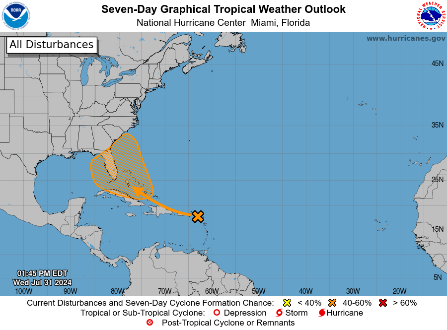
Possible development in the Western Atlantic / GOM (Is Invest 97L)

This is the general tropical discussion area. Anyone can take their shot at predicting a storms path.

Moderator: S2k Moderators

Forum rules

The posts in this forum are NOT official forecasts and should not be used as such. They are just the opinion of the poster and may or may not be backed by sound meteorological data. They are NOT endorsed by any professional institution or STORM2K. For official information, please refer to products from the National Hurricane Center and National Weather Service.

Help Support Storm2K
Message
Author
User avatar
SFLcane
S2K Supporter
S2K Supporter
Posts: 10162
Age: 47
Joined: Sat Jun 05, 2010 1:44 pm
Location: Lake Worth Florida

Re: Possible development in the Western Atlantic (0/60)

#461 Postby SFLcane » Wed Jul 31, 2024 12:59 pm

wzrgirl1 wrote:
cycloneye wrote:
SFLcane wrote:Copy and paste NHC 2PM TWO.


Tropical Weather Outlook
NWS National Hurricane Center Miami FL
200 PM EDT Wed Jul 31 2024

For the North Atlantic...Caribbean Sea and the Gulf of Mexico:

Near the Greater Antilles and the Bahamas:
A large tropical wave located over the Lesser Antilles continues to
produce a broad area of disorganized showers and thunderstorms.
While development in the short-term is not anticipated as the system
moves over portions of the Greater Antilles, environmental
conditions are forecast to gradually become more conducive for
development as the system moves generally west-northwestward towards
the Bahamas and Cuba. A tropical depression could form this weekend
or early next week when the system is in the vicinity of the Greater
Antilles, Bahamas, or near Florida. Interests in the Greater
Antilles, the Bahamas, and the southeastern U.S. should monitor the
progress of this system.
* Formation chance through 48 hours...low...near 0 percent.
* Formation chance through 7 days...medium...60 percent.

$$
Forecaster Papin/Landsea


Has the "development cone" changed since this morning?


Image
0 likes   

Frank P
S2K Supporter
S2K Supporter
Posts: 2772
Joined: Fri Aug 29, 2003 10:52 am
Location: Biloxi Beach, Ms
Contact:

Re: Possible development in the Western Atlantic (0/60)

#462 Postby Frank P » Wed Jul 31, 2024 1:02 pm

Euro 12z makes landfall near Mexico Beach, but quite weak... hard to believe this system will be that weak with east GOM temps absolutely boiling...
0 likes   

User avatar
wzrgirl1
S2K Supporter
S2K Supporter
Posts: 1323
Joined: Sat Sep 04, 2004 6:44 am
Location: Pembroke Pines, Florida

Re: Possible development in the Western Atlantic (0/60)

#463 Postby wzrgirl1 » Wed Jul 31, 2024 1:02 pm

Yes the development cone shifted noticeably west.
0 likes   

BobHarlem
Category 5
Category 5
Posts: 2034
Joined: Thu Oct 20, 2005 6:11 pm

Re: Possible development in the Western Atlantic (0/60)

#464 Postby BobHarlem » Wed Jul 31, 2024 1:09 pm

Well some sort of agreement now between the two major models, just a LOT of rain. Euro does hang out more inland and crosses over Central Florida unlike GFS which eventually wanders over toward Alabama, but still tons of rain for the peninsula in either case. (GFS is stronger though)

Image
0 likes   

User avatar
wxman57
Moderator-Pro Met
Moderator-Pro Met
Posts: 22951
Age: 67
Joined: Sat Jun 21, 2003 8:06 pm
Location: Houston, TX (southwest)

Re: Possible development in the Western Atlantic (0/60)

#465 Postby wxman57 » Wed Jul 31, 2024 1:11 pm

Euro doesn't develop a TD until it's east of Florida next Wed-Thu. Just general low pressure in the eastern Gulf but lots of rain for Florida. It's suggesting a possible hurricane heading north toward Long Island in 11-12 days.
0 likes   

3090
Category 2
Category 2
Posts: 548
Age: 65
Joined: Fri Aug 19, 2011 4:01 pm

Re: Possible development in the Western Atlantic (0/60)

#466 Postby 3090 » Wed Jul 31, 2024 1:15 pm

wxman57 wrote:Euro doesn't develop a TD until it's east of Florida next Wed-Thu. Just general low pressure in the eastern Gulf but lots of rain for Florida.

By Sunday, 8/4, the ECMF has the 1011 low in the southern/SE GOM, off the northwest end of Cuba. Not much of a system at that time. Broad. BIG time POTENTIAL flooding rains for Florida.

A tropical system, does not need to be a named system, to cause major damage.

All eyes need to be focused on this system going forward.
Last edited by 3090 on Wed Jul 31, 2024 1:20 pm, edited 1 time in total.
1 likes   

User avatar
sunnyday
Category 5
Category 5
Posts: 1590
Joined: Thu Sep 04, 2003 8:16 pm

Re: Possible development in the Western Atlantic (0/60)

#467 Postby sunnyday » Wed Jul 31, 2024 1:16 pm

When does the so-called force field come into play that often protects Florida’s east coast and particularly the SE coast of the state?
0 likes   

jlauderdal
S2K Supporter
S2K Supporter
Posts: 7177
Joined: Wed May 19, 2004 5:46 am
Location: NE Fort Lauderdale
Contact:

Re: Possible development in the Western Atlantic (0/60)

#468 Postby jlauderdal » Wed Jul 31, 2024 1:22 pm

sunnyday wrote:When does the so-called force field come into play that often protects Florida’s east coast and particularly the SE coast of the state?

When I fire up my generator, which will be soon if this continues, some of you know what I am talking about. :D

I still dont buy the Euro AI with the loop off the East Coast going into the gulf. The loop or stall scenario seems more likely today. Be very careful with intensity, dont read too much into weak or strong at this point as it nears the lower 48.
0 likes   

User avatar
toad strangler
S2K Supporter
S2K Supporter
Posts: 4543
Joined: Sun Jul 28, 2013 3:09 pm
Location: Earth
Contact:

Re: Possible development in the Western Atlantic (0/60)

#469 Postby toad strangler » Wed Jul 31, 2024 1:23 pm

sunnyday wrote:When does the so-called force field come into play that often protects Florida’s east coast and particularly the SE coast of the state?


There is no such thing lol. Just circumstance. It's often used in jest when a tropical system veers away in the 4th quarter or anytime really. Just a joke.
1 likes   

User avatar
sunnyday
Category 5
Category 5
Posts: 1590
Joined: Thu Sep 04, 2003 8:16 pm

Re: Possible development in the Western Atlantic (0/60)

#470 Postby sunnyday » Wed Jul 31, 2024 1:30 pm

I was speaking in jest about the force field b c people joke about it here. I definitely know there is no such thing.
3 likes   

Stratton23
Category 5
Category 5
Posts: 2370
Joined: Fri Jul 21, 2023 10:59 pm
Location: Katy, Tx

Re: Possible development in the Western Atlantic (0/60)

#471 Postby Stratton23 » Wed Jul 31, 2024 1:34 pm

EPS has more members stalling in the gulf, some go up the east coast, and some get shoved more westward by the building upper level ridge
0 likes   

User avatar
Steve
S2K Supporter
S2K Supporter
Posts: 9591
Joined: Sat Apr 05, 2003 11:41 pm
Location: Not a state-caster

Re: Possible development in the Western Atlantic (0/60)

#472 Postby Steve » Wed Jul 31, 2024 1:39 pm

Stratton23 wrote:And to no ones surprise, the euro caves to the GFS, showing a stall in the NE gulf now


It's not necessarily a surprise, but I wouldn't have laid money on it. When in doubt the EC has been more right over the years. It still can go a lot of ways including split energy though if the southern "lobe" is the dominant one, the move toward FL or west of FL makes sense. Plus the GFS is aligned with the MJO and also climatology for this one being so early in August where you have to think more left and stronger ridging as a general rule.
3 likes   

User avatar
SFLcane
S2K Supporter
S2K Supporter
Posts: 10162
Age: 47
Joined: Sat Jun 05, 2010 1:44 pm
Location: Lake Worth Florida

Re: Possible development in the Western Atlantic (0/60)

#473 Postby SFLcane » Wed Jul 31, 2024 1:44 pm

0 likes   

User avatar
Steve
S2K Supporter
S2K Supporter
Posts: 9591
Joined: Sat Apr 05, 2003 11:41 pm
Location: Not a state-caster

Re: Possible development in the Western Atlantic (0/60)

#474 Postby Steve » Wed Jul 31, 2024 1:48 pm

1 likes   

User avatar
SFLcane
S2K Supporter
S2K Supporter
Posts: 10162
Age: 47
Joined: Sat Jun 05, 2010 1:44 pm
Location: Lake Worth Florida

Re: Possible development in the Western Atlantic (0/60)

#475 Postby SFLcane » Wed Jul 31, 2024 1:50 pm

Last edited by SFLcane on Wed Jul 31, 2024 1:53 pm, edited 1 time in total.
0 likes   

User avatar
AtlanticWind
S2K Supporter
S2K Supporter
Posts: 1885
Age: 66
Joined: Sun Aug 08, 2004 9:57 pm
Location: Plantation,Fla

Re: Possible development in the Western Atlantic (0/60)

#476 Postby AtlanticWind » Wed Jul 31, 2024 1:51 pm

The Euro run is concerning for rainfall in Florida moving system slowly across state from the gulf
0 likes   

BobHarlem
Category 5
Category 5
Posts: 2034
Joined: Thu Oct 20, 2005 6:11 pm

Re: Possible development in the Western Atlantic (0/60)

#477 Postby BobHarlem » Wed Jul 31, 2024 2:02 pm

AtlanticWind wrote:The Euro run is concerning for rainfall in Florida moving system slowly across state from the gulf


The general setup for a stall is concerning, crazy rainfall either way, but a stall over water vs land could change the whole dynamic, or center relocations, etc. (See GFS getting to cat 2)

Tidbits flavor of the GFS Total precip (24" scale top)
Image
2 likes   

LarryWx
Category 5
Category 5
Posts: 6246
Joined: Sun Sep 07, 2003 2:04 pm
Location: GA

Re: Possible development in the Western Atlantic (0/60)

#478 Postby LarryWx » Wed Jul 31, 2024 2:21 pm

12Z JMA unlike the prior 12Z JMA does come back ENE to E of N FL
1 likes   
Personal Forecast Disclaimer:
The posts in this forum are NOT official forecasts and should not be used as such. They are just the opinion of the poster and may or may not be backed by sound meteorological data. They are NOT endorsed by any professional institution or storm2k.org. For official information, please refer to the NHC and NWS products.

User avatar
weeniepatrol
Category 5
Category 5
Posts: 1252
Joined: Sat Aug 22, 2020 5:30 pm
Location: WA State

Re: Possible development in the Western Atlantic (0/60)

#479 Postby weeniepatrol » Wed Jul 31, 2024 2:28 pm

really really REALLY not a fan of some of these model solutions...

Image
1 likes   

User avatar
Emmett_Brown
Category 5
Category 5
Posts: 1432
Joined: Wed Aug 24, 2005 9:10 pm
Location: Sarasota FL

Re: Possible development in the Western Atlantic (0/60)

#480 Postby Emmett_Brown » Wed Jul 31, 2024 2:33 pm

SSTs are VERY warm in the E GOM... widespread area of 30 C and higher. Models depict low shear in the E GOM this weekend as well. It would be nice to get some hurricane models running on this
0 likes   


Return to “Talkin' Tropics”

Who is online

Users browsing this forum: No registered users and 184 guests