

Gulf Coast Disturbance (early August)
Moderator: S2k Moderators
Forum rules

The posts in this forum are NOT official forecasts and should not be used as such. They are just the opinion of the poster and may or may not be backed by sound meteorological data. They are NOT endorsed by any professional institution or STORM2K. For official information, please refer to products from the National Hurricane Center and National Weather Service.
-
Stormcenter
- S2K Supporter

- Posts: 6689
- Joined: Wed Sep 03, 2003 11:27 am
- Location: Houston, TX
-
tolakram
- Admin

- Posts: 20179
- Age: 62
- Joined: Sun Aug 27, 2006 8:23 pm
- Location: Florence, KY (name is Mark)
Re: Central Gulf Coast Disturbance
Saved Radar Loop

Total Storm precip loop

Total Storm precip loop
1 likes
M a r k
- - - - -
Join us in chat: Storm2K Chatroom Invite. Android and IOS apps also available.
The posts in this forum are NOT official forecasts and should not be used as such. Posts are NOT endorsed by any professional institution or STORM2K.org. For official information and forecasts, please refer to NHC and NWS products.
-
USTropics
- Professional-Met

- Posts: 2737
- Joined: Sun Aug 12, 2007 3:45 am
- Location: Florida State University
Re: Central Gulf Coast Disturbance
The latest 12z GFS total accumulated precipitation over the next 48 hours looks pretty ominous for portions of LA. Projecting 20+ inches:

0 likes
-
USTropics
- Professional-Met
- Posts: 2737
- Joined: Sun Aug 12, 2007 3:45 am
- Location: Florida State University
Re: Central Gulf Coast Disturbance
The 12z CMC and NAM have the majority of the precipitation more north compared to the GFS, extending into portions of Mississippi:

The GFS has handled this situation pretty well over the past 7 days compared to the CMC. Current circulation hasn't moved much inland per recent radar images. The majority of the deep convection is on the southern side as well.
The WRF also has a similar setup to the GFS:

The GFS has handled this situation pretty well over the past 7 days compared to the CMC. Current circulation hasn't moved much inland per recent radar images. The majority of the deep convection is on the southern side as well.
The WRF also has a similar setup to the GFS:
1 likes
-
BigB0882
- S2K Supporter
- Posts: 2291
- Joined: Thu Jul 03, 2003 12:08 am
- Location: Baton Rouge, LA
- Contact:
Re: Central Gulf Coast Disturbance
I live in Baton Rouge and it has been a steady rain that just wont stop. Not the heavy downpours you get with afternoon thunderstorms but the persistent tropical rain you would expect with this kind of system. If that GFS is right then we are in very big trouble as flooding is a major issue already around here. I can't imagine another 20 inches or even another 10! I am hoping it is over-doing it and the next run will show something different but the GFS is hard to ignore when you are talking about only 24 hours out. This also isn't about banding and wondering where it will set up because it is a steady rainfall over a very large area.
2 likes
-
USTropics
- Professional-Met
- Posts: 2737
- Joined: Sun Aug 12, 2007 3:45 am
- Location: Florida State University
Re: Central Gulf Coast Disturbance
Total observed rainfall (in inches) from August 4th through 10:00AM ET today:
Code: Select all
LOUISIANA
DENHAM SPRINGS 4.1 NE                15.17
CENTRAL 2.2 SE                       13.68
BROWNFIELDS 4.0 E                    13.13
TICKFAW 2.0 SSW                      12.75
MONTICELLO 3.0 ENE                   12.72
BATON ROUGE 2.5 E                    10.29
MADISONVILLE 3.2 NNW                 10.23
FRANKLINTON                           9.25
KENTWOOD                              8.84
Code: Select all
MISSISSIPPI
WAVELAND 1.0 NW                      11.00
PASS CHRISTIAN 3.5 NE                10.56
OCEAN SPRINGS 3.6 ESE                10.48
GLOSTER 1.9 SSW                      10.20
DIAMONDHEAD 0.4 E                     9.84
GULFPORT-BILOXI                       7.87
JACKSON WFO                           5.63
PASCAGOULA                            3.87
Code: Select all
FLORIDA
PANAMA CITY BEACH 5.9 WNW            14.43
BRONSON 3.0 SE                       12.80
HATCH BEND 9 WNW                     12.40
VERO BEACH 2.4 W                     12.16
CROSS CITY ARPT                      10.98
TYNDALL AFB                          10.88
MIRAMAR BEACH 9.5 ESE                10.17
SPRING HILL 2.4 NW                   10.06
MIDWAY                               10.00
WEEKI WACHEE 7.1 NNE                  9.96
PENSACOLA NAS                         9.72
HORSESHOW BEACH                       8.90
VERO BEACH MUNI ARPT                  8.52
GULFPORT 0.9 NNW                      8.10
TALLAHASSEE 9.6 N                     6.88
Code: Select all
ALABAMA
FOLEY 0.5 ESE                         7.58
FAIRHOPE 1.5 WSW                      7.45
SUMMERDALE 4.3 WSW                    7.03
EVERGREEN                             5.55
CAIRNS AAF/OZARK                      4.22
MOBILE DOWNTOWN AIRPORT               3.21
2 likes

-
USTropics
- Professional-Met
- Posts: 2737
- Joined: Sun Aug 12, 2007 3:45 am
- Location: Florida State University
Re: Central Gulf Coast Disturbance
BigB0882 wrote:I live in Baton Rouge and it has been a steady rain that just wont stop. Not the heavy downpours you get with afternoon thunderstorms but the persistent tropical rain you would expect with this kind of system. If that GFS is right then we are in very big trouble as flooding is a major issue already around here. I can't imagine another 20 inches or even another 10! I am hoping it is over-doing it and the next run will show something different but the GFS is hard to ignore when you are talking about only 24 hours out. This also isn't about banding and wondering where it will set up because it is a steady rainfall over a very large area.
The GFS is most likely overdoing the total accumulated rainfall (the last 5-6 runs have consistently shown this scenario however). Blending the models together, I'd expect ~10 inches in central LA with isolated areas seeing 15 inches. The low pressure is starting to slowly move westward, but it's still going to pull in copious amounts of moisture from the GOM over the weekend.
A cold front currently situated over the Central Plains should merge with this low pressure system later in the forecast period. The CMC/NAM model indicate a northward shift as a result of this, which is a plausible scenario (and one LA residents are hoping for).
0 likes

Re: Central Gulf Coast Disturbance
bamajammer4eva wrote:An area South of Greensburg, La is showing over 40 inches radar estimate. I had a color table that went higher but don't remember where to find it but dragging the curser through the area showed this.

40 inches is really high! I have not seen that amount measured.
0 likes

Re: Central Gulf Coast Disturbance
Following this low all over the place feels just a little bit as if someone had taken what was to be Hurricane Elena from 1985 but accidentally shifter her about 100 miles too far to the north rather than over water.
3 likes
Andy D
(For official information, please refer to the NHC and NWS products.)
(For official information, please refer to the NHC and NWS products.)
-
SEASON_CANCELED

- Category 3

- Posts: 887
- Joined: Mon Jul 06, 2009 5:17 am
- Location: 8 Bit Charlie Sheen
Re: Central Gulf Coast Disturbance
I know we all are asking this but ,This wont develop overland will it?? (can it?)
0 likes
i am a big stupid ugly moron with an ugly face and a big butt and my butt stinks and i like to kiss my own butt
-
USTropics
- Professional-Met
- Posts: 2737
- Joined: Sun Aug 12, 2007 3:45 am
- Location: Florida State University
Re: Central Gulf Coast Disturbance
Record Flooding in Southeast Louisiana May Get Worse
By: Bob Henson , 8:20 PM GMT on August 12, 2016
A devastating flood event was unfolding over southeast Louisiana on Friday, and conditions may get worse yet, as an extremely slow-moving center of low pressure is dumping colossal amounts of rain on the region. This sprawling, “stacked” low is carrying more water vapor than many tropical cyclones, and its slow motion is leading to persistent rains that could add up to all-time record totals in some places.
Multi-sensor analyses indicate that several areas in southeast Louisiana and southermost Mississippi racked up more than 6” of rain from 7:00 am CDT Thursday, August 11, to 7:00 am Friday (see Figure 1). More than 10” of rain was analyzed just northeast of Baton Rouge, the hardest-hit area thus far. In the 24 hours from 2:00 pm CDT Thursday to 2:00 pm Friday, Baton Rouge Metropolitan Airport recorded a preliminary total of 8.49” of rain. Since records began in 1892, the city’s largest calendar day total is 11.99” (set on April 14, 1967), and the largest two-day calendar total is 14.03” (June 6-7, 2001). Given the very slow motion of the stacked low, these all-time records are conceivably within reach. A cooperative observer in Livingston, LA, reported 17.09” of rain from midnight to 3:00 pm CDT Friday. The state’s official 24-hour record is 22 inches, reported near Hackberry on August 28-29, 1962.

Figure 1. Multi-sensor rainfall analysis for the period from 7:00 am CDT Thursday, August 11, to 7:00 am Friday shows a gyre-like pattern of torrential rains spinning around a low in southern Mississippi. Image credit: NOAA/NWS Advanced Hydrologic Prediction Service.
As the low edges westward over the next 24-48 hours, the zone of heaviest rain potential will shift toward west Louisiana and east Texas, but southeast Louisiana will remain under the gun for more downpours at least into early Saturday. The short-range HRRR model produces another 2”-6” of widespread rain over southeast Louisiana through Saturday morning, with localized totals of 8-12” not out of the question.

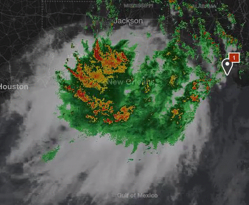
Figure 2. Enhanced infrared satellite image for the central Gulf Coast reveals the vast scope of the area of low pressure generating torrential rains in southeast Louisiana. Image credit: NOAA/NESDIS
Severe flood threat for Baton Rouge area
Both flash flooding and river flooding threats are looming large for southeast Louisiana, where flash flood warnings were in place on Friday afternoon. Major flooding has already occurred throughout the day Friday, and a flash flood emergency (the most urgent type of flash flood warning) was in effect Friday afternoon for parts of Feliciana, West Feliciana, St. Helena, and East Baton Rouge parishes, which extend roughly from Baton Rouge northward. Water rescues and evacuations were under way in this region, according to the NWS. Even if the rains ease during the weekend, the area faces a major flood threat. The Tickfaw River at Montpelier, LA, hit a record crest of 22.75 feet at 1:30 pm CDT Friday, with several more feet expected this weekend. A number of other rivers across southeast Louisiana are projected to reach all-time crests, including the Amite River, where record levels of flooding can be expected to inundate many homes and roadways on the eastern side of the Baton Rouge metro area for an extended period.

Figure 3. Forecasts issued on Friday morning, August 12, 2016, were calling for an all-time record flood crest of 42.5 feet late Sunday on the Amite River at Denham Springs, just east of Baton Rouge, LA. The forecast keeps waters above the previous record of 41.5 feet (April 8, 1983) for a full 24 hours. These projections could be boosted further in light of the heavy rains persisting in the area on Friday. The last major crest in this region was 36.09 feet on March 13, 2016. Image credit: NOAA/NWS Advanced Hydrologic Prediction Service.
Tropical cyclone or not? Does it matter?
Although this system does not qualify as a tropical cyclone--its center has remained just inland--the point is moot in terms of impact, as the torrential rains and flooding from this low could end up ranking among some of the more damaging tropical depressions and tropical storms on record. The low’s rainmaking power is a combination of its extremely slow motion and the astoundingly moist air mass feeding into it. The upper air sounding launched from Slidell, LA, at 12Z Friday (7:00 am CDT) showed that the atmosphere was carrying 2.85” of precipitable water (the amount of water in a column of air over a given point). This is the second-highest amount of water measured in any sounding since records began in the New Orleans area in 1948, and just 0.03” below the record of 2.88”. In Jackson, MS, only two other dates have seen more precipitable water than the 2.74” measured on Friday morning, with the record being just 0.02” higher (2.76”). These values may seem puzzlingly low compared to the amounts of rain occurring. This is because showers and thunderstorms can concentrate the amount of moisture present in the atmosphere throughout a region, so they can produce much higher local totals than the precipitable water values would suggest.
The New Orleans Times-Picayune is providing live updates on the situation in southeast Louisiana. Governor John Bel Edwards has declared a state of emergency for the entire state through at least Saturday.

Figure 4. An inundated boat launch ramp in New Iberia, LA, on Friday, August 12, 2016. Image credit: wunderphotographer kaiju76.
By: Bob Henson , 8:20 PM GMT on August 12, 2016
A devastating flood event was unfolding over southeast Louisiana on Friday, and conditions may get worse yet, as an extremely slow-moving center of low pressure is dumping colossal amounts of rain on the region. This sprawling, “stacked” low is carrying more water vapor than many tropical cyclones, and its slow motion is leading to persistent rains that could add up to all-time record totals in some places.
Multi-sensor analyses indicate that several areas in southeast Louisiana and southermost Mississippi racked up more than 6” of rain from 7:00 am CDT Thursday, August 11, to 7:00 am Friday (see Figure 1). More than 10” of rain was analyzed just northeast of Baton Rouge, the hardest-hit area thus far. In the 24 hours from 2:00 pm CDT Thursday to 2:00 pm Friday, Baton Rouge Metropolitan Airport recorded a preliminary total of 8.49” of rain. Since records began in 1892, the city’s largest calendar day total is 11.99” (set on April 14, 1967), and the largest two-day calendar total is 14.03” (June 6-7, 2001). Given the very slow motion of the stacked low, these all-time records are conceivably within reach. A cooperative observer in Livingston, LA, reported 17.09” of rain from midnight to 3:00 pm CDT Friday. The state’s official 24-hour record is 22 inches, reported near Hackberry on August 28-29, 1962.
Figure 1. Multi-sensor rainfall analysis for the period from 7:00 am CDT Thursday, August 11, to 7:00 am Friday shows a gyre-like pattern of torrential rains spinning around a low in southern Mississippi. Image credit: NOAA/NWS Advanced Hydrologic Prediction Service.
As the low edges westward over the next 24-48 hours, the zone of heaviest rain potential will shift toward west Louisiana and east Texas, but southeast Louisiana will remain under the gun for more downpours at least into early Saturday. The short-range HRRR model produces another 2”-6” of widespread rain over southeast Louisiana through Saturday morning, with localized totals of 8-12” not out of the question.
Figure 2. Enhanced infrared satellite image for the central Gulf Coast reveals the vast scope of the area of low pressure generating torrential rains in southeast Louisiana. Image credit: NOAA/NESDIS
Severe flood threat for Baton Rouge area
Both flash flooding and river flooding threats are looming large for southeast Louisiana, where flash flood warnings were in place on Friday afternoon. Major flooding has already occurred throughout the day Friday, and a flash flood emergency (the most urgent type of flash flood warning) was in effect Friday afternoon for parts of Feliciana, West Feliciana, St. Helena, and East Baton Rouge parishes, which extend roughly from Baton Rouge northward. Water rescues and evacuations were under way in this region, according to the NWS. Even if the rains ease during the weekend, the area faces a major flood threat. The Tickfaw River at Montpelier, LA, hit a record crest of 22.75 feet at 1:30 pm CDT Friday, with several more feet expected this weekend. A number of other rivers across southeast Louisiana are projected to reach all-time crests, including the Amite River, where record levels of flooding can be expected to inundate many homes and roadways on the eastern side of the Baton Rouge metro area for an extended period.
Figure 3. Forecasts issued on Friday morning, August 12, 2016, were calling for an all-time record flood crest of 42.5 feet late Sunday on the Amite River at Denham Springs, just east of Baton Rouge, LA. The forecast keeps waters above the previous record of 41.5 feet (April 8, 1983) for a full 24 hours. These projections could be boosted further in light of the heavy rains persisting in the area on Friday. The last major crest in this region was 36.09 feet on March 13, 2016. Image credit: NOAA/NWS Advanced Hydrologic Prediction Service.
Tropical cyclone or not? Does it matter?
Although this system does not qualify as a tropical cyclone--its center has remained just inland--the point is moot in terms of impact, as the torrential rains and flooding from this low could end up ranking among some of the more damaging tropical depressions and tropical storms on record. The low’s rainmaking power is a combination of its extremely slow motion and the astoundingly moist air mass feeding into it. The upper air sounding launched from Slidell, LA, at 12Z Friday (7:00 am CDT) showed that the atmosphere was carrying 2.85” of precipitable water (the amount of water in a column of air over a given point). This is the second-highest amount of water measured in any sounding since records began in the New Orleans area in 1948, and just 0.03” below the record of 2.88”. In Jackson, MS, only two other dates have seen more precipitable water than the 2.74” measured on Friday morning, with the record being just 0.02” higher (2.76”). These values may seem puzzlingly low compared to the amounts of rain occurring. This is because showers and thunderstorms can concentrate the amount of moisture present in the atmosphere throughout a region, so they can produce much higher local totals than the precipitable water values would suggest.
The New Orleans Times-Picayune is providing live updates on the situation in southeast Louisiana. Governor John Bel Edwards has declared a state of emergency for the entire state through at least Saturday.
Figure 4. An inundated boat launch ramp in New Iberia, LA, on Friday, August 12, 2016. Image credit: wunderphotographer kaiju76.
1 likes

Re: Central Gulf Coast Disturbance
Wind in Biloxi has been stiff since around 11 this morning. Presently at 22 out of the SW with gusts to 30.
1 likes
-
wxman57

- Moderator-Pro Met

- Posts: 23172
- Age: 68
- Joined: Sat Jun 21, 2003 8:06 pm
- Location: Houston, TX (southwest)
Re: Central Gulf Coast Disturbance
SEASON_CANCELED wrote:I know we all are asking this but ,This wont develop overland will it?? (can it?)
Well, I suppose that if enough rain falls such that the Louisiana coast retreats north of Alexandria, then there may be development potential, as the low center would then be over water. Otherwise, no chance.
1 likes


Re: Central Gulf Coast Disturbance
The rain let up today in Biloxi somewhat. The winds have kicked in instead. Not real strong, but continual and tropical. Around 25 mph.
1 likes
-
Frank P
- S2K Supporter
- Posts: 2779
- Joined: Fri Aug 29, 2003 10:52 am
- Location: Biloxi Beach, Ms
- Contact:
Re: Central Gulf Coast Disturbance
We've had wind gusts on the beach today up to 37 mph today, pressure at 3:51pm is at 1011.2 and falling with steady state winds above 20 mph all afternoon.. at least the rainfall on the Biloxi beach has not been that bad since this morning..
0 likes
-
USTropics
- Professional-Met
- Posts: 2737
- Joined: Sun Aug 12, 2007 3:45 am
- Location: Florida State University
Re: Central Gulf Coast Disturbance
Latest WPC 7-day OPF. Rain will make its way towards eastern/central Texas after immersing LA/Central Plains:

1 likes

Re: Central Gulf Coast Disturbance
This is one of Baton Rouge's news channels that is covering this event.
http://www.wafb.com/
I live in the area about 20 miles south of some of those 15+ inches, only 6 inches on my rain gauge. But we'll be dealing with flooding( river)for probably close to a week. I'll try to post some pics later.
http://www.wafb.com/
I live in the area about 20 miles south of some of those 15+ inches, only 6 inches on my rain gauge. But we'll be dealing with flooding( river)for probably close to a week. I'll try to post some pics later.
1 likes
The following post is NOT an official forecast and should not be used as such. It is just the opinion of the poster and may or may not be backed by sound meteorological data. It is NOT endorsed by any professional institution including storm2k.org For Official Information please refer to the NHC and NWS products.
Who is online
Users browsing this forum: No registered users and 189 guests