Hmmm... I wonder if the swath of above normal precipitation is a hint as to what the mean tracks might be like for this seasons Cape Verde storms. Looks as if it is suggesting the Bermuda High to possibly setup shop just off the east coast again.
2017 indicators: SST's / MSLP / SAL / Steering / Instability
Moderator: S2k Moderators
Forum rules

The posts in this forum are NOT official forecasts and should not be used as such. They are just the opinion of the poster and may or may not be backed by sound meteorological data. They are NOT endorsed by any professional institution or STORM2K. For official information, please refer to products from the National Hurricane Center and National Weather Service.
-
TheStormExpert
Re: 2017 indicators: SST's / MSLP / SAL / Steering / Instability
Hmmm... I wonder if the swath of above normal precipitation is a hint as to what the mean tracks might be like for this seasons Cape Verde storms. Looks as if it is suggesting the Bermuda High to possibly setup shop just off the east coast again.
0 likes
-
gatorcane

- S2K Supporter

- Posts: 23708
- Age: 48
- Joined: Sun Mar 13, 2005 3:54 pm
- Location: Boca Raton, FL
Re: 2017 indicators: SST's / MSLP / SAL / Steering / Instability
Seems like a pretty active ITCZ for this time of year from Panama out into the Eastern Atlantic. We will see this ITCZ move north over the next few of months. A sign of an active MDR come Aug through Oct?

1 likes
-
Hurricaneman

- Category 5

- Posts: 7404
- Age: 45
- Joined: Tue Aug 31, 2004 3:24 pm
- Location: central florida
Re: 2017 indicators: SST's / MSLP / SAL / Steering / Instability
Looking at things It looks like 2004 may not be a bad analog as the Atlantic and EPAC don't look to dissimilar to that year this year and just like 2004 the ITCZ is quite active
0 likes
-
TheStormExpert
Re: 2017 indicators: SST's / MSLP / SAL / Steering / Instability
Hurricaneman wrote:Looking at things It looks like 2004 may not be a bad analog as the Atlantic and EPAC don't look to dissimilar to that year this year and just like 2004 the ITCZ is quite active
Do you have visual proof? You've been saying that 2004 is an analog for quite awhile.
0 likes
-
Hurricaneman
- Category 5
- Posts: 7404
- Age: 45
- Joined: Tue Aug 31, 2004 3:24 pm
- Location: central florida
Re: 2017 indicators: SST's / MSLP / SAL / Steering / Instability
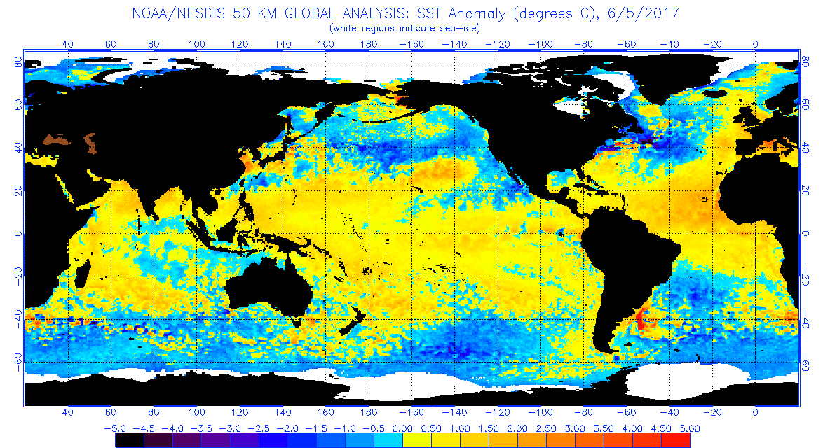
As far as ocean anomalies 2004 is the closest match especially on the pacific side but it seem I was wrong with the ITCZ as it more matches 2003 and 2005 which is very interesting and 1980 had similar activity in the ITCZ
https://www.ncdc.noaa.gov/gibbs/html/GO ... 3-06-10-21
https://www.ncdc.noaa.gov/gibbs/html/GO ... 5-06-08-03
https://www.ncdc.noaa.gov/gibbs/html/SM ... 0-06-08-12
http://www.ospo.noaa.gov/data/sst/anoma ... 5.2017.gif
http://www.ospo.noaa.gov/data/sst/anoma ... 8.2004.gif
https://www.ncdc.noaa.gov/gibbs/html/GO ... 3-06-10-21
https://www.ncdc.noaa.gov/gibbs/html/GO ... 5-06-08-03
https://www.ncdc.noaa.gov/gibbs/html/SM ... 0-06-08-12
http://www.ospo.noaa.gov/data/sst/anoma ... 5.2017.gif
http://www.ospo.noaa.gov/data/sst/anoma ... 8.2004.gif
1 likes
-
tarheelprogrammer

- S2K Supporter
- Posts: 1793
- Joined: Mon Mar 28, 2016 9:25 pm
- Location: Raleigh, NC area (Garner, NC)
Re: 2017 indicators: SST's / MSLP / SAL / Steering / Instability
So, the new run lowered the numbers from the previous run?
0 likes
My posts are not official forecasts. They are just my opinion and may or may not be backed by sound meteorological data. They are NOT endorsed by any professional institution or storm2k.org. For official information, please refer to the NHC and NWS products.


Re: 2017 indicators: SST's / MSLP / SAL / Steering / Instability
Overall at the moment, the Globe's activity is running much below normal this year. IF and if there is some surprise lesser season, we would likely have to see links. That is a big if currently.
0 likes
The above post and any post by Ntxw is NOT an official forecast and should not be used as such. It is just the opinion of the poster and may or may not be backed by sound meteorological data. It is NOT endorsed by any professional institution including Storm2k. For official information, please refer to NWS products.
Help support Storm2K!
-
wxman57

- Moderator-Pro Met

- Posts: 23172
- Age: 68
- Joined: Sat Jun 21, 2003 8:06 pm
- Location: Houston, TX (southwest)
Re: 2017 indicators: SST's / MSLP / SAL / Steering / Instability
June ECMWF seasonal charts came out this morning. Its Nino 3.4 forecast is for significantly cooler peak-season temps than in its April and May forecasts. Not much above normal there, temperature-wise in Aug-Oct. It's still only forecasting 12 named storms. However, it went from 7.2 to 8.1 hurricanes between the May and June forecasts. ACE 90% of normal.
1 likes
-
Bocadude85
- Category 5
- Posts: 2991
- Age: 39
- Joined: Mon Apr 18, 2005 2:20 pm
- Location: Honolulu,Hi
Re: 2017 indicators: SST's / MSLP / SAL / Steering / Instability
tarheelprogrammer wrote:TheStormExpert wrote:https://twitter.com/ryanmaue/status/872842101037436929
https://twitter.com/ryanmaue/status/872842733035163648
So, the new run lowered the numbers from the previous run?
The new run shows the same amount of NS and hurricanes as the May update.
1 likes
-
tarheelprogrammer
- S2K Supporter
- Posts: 1793
- Joined: Mon Mar 28, 2016 9:25 pm
- Location: Raleigh, NC area (Garner, NC)
Re: 2017 indicators: SST's / MSLP / SAL / Steering / Instability
Bocadude85 wrote:tarheelprogrammer wrote:TheStormExpert wrote:https://twitter.com/ryanmaue/status/872842101037436929
https://twitter.com/ryanmaue/status/872842733035163648
So, the new run lowered the numbers from the previous run?
The new run shows the same amount of NS and hurricanes as the May update.
I just seen the ECMWF SSTs, and it is odd that it keeps the same numbers as before. That set up seems to favor the Atlantic a lot. It has a warm MDR, and a cooler Pacific. Hmmm
0 likes
My posts are not official forecasts. They are just my opinion and may or may not be backed by sound meteorological data. They are NOT endorsed by any professional institution or storm2k.org. For official information, please refer to the NHC and NWS products.
-
tarheelprogrammer
- S2K Supporter
- Posts: 1793
- Joined: Mon Mar 28, 2016 9:25 pm
- Location: Raleigh, NC area (Garner, NC)
Re: 2017 indicators: SST's / MSLP / SAL / Steering / Instability
Here is the SST gif showing the changes from Feb to June below:
https://twitter.com/MJVentrice/status/872853627685228545
https://twitter.com/MJVentrice/status/872853627685228545
0 likes
My posts are not official forecasts. They are just my opinion and may or may not be backed by sound meteorological data. They are NOT endorsed by any professional institution or storm2k.org. For official information, please refer to the NHC and NWS products.
-
SFLcane

- S2K Supporter
- Posts: 10281
- Age: 48
- Joined: Sat Jun 05, 2010 1:44 pm
- Location: Lake Worth Florida
Re: 2017 indicators: SST's / MSLP / SAL / Steering / Instability
Signs keep pointing towards a busy season.
2 likes
-
SFLcane
- S2K Supporter
- Posts: 10281
- Age: 48
- Joined: Sat Jun 05, 2010 1:44 pm
- Location: Lake Worth Florida
Re: 2017 indicators: SST's / MSLP / SAL / Steering / Instability
wxman57 wrote:June ECMWF seasonal charts came out this morning. Its Nino 3.4 forecast is for significantly cooler peak-season temps than in its April and May forecasts. Not much above normal there, temperature-wise in Aug-Oct. It's still only forecasting 12 named storms. However, it went from 7.2 to 8.1 hurricanes between the May and June forecasts. ACE 90% of normal.
57 odd not much of an increase in named storms. Seems like a favorable pattern for the Atlantic.
2 likes

Re: 2017 indicators: SST's / MSLP / SAL / Steering / Instability
below average activity off of the coast of Mexico as predicted by the EC
1 likes
-
TheStormExpert
Re: 2017 indicators: SST's / MSLP / SAL / Steering / Instability
Has the ECMWF's June MSLP map come out yet?
0 likes
-
cycloneye

- Admin

- Posts: 149275
- Age: 69
- Joined: Thu Oct 10, 2002 10:54 am
- Location: San Juan, Puerto Rico
Re: 2017 indicators: SST's / MSLP / SAL / Steering / Instability
TheStormExpert wrote:Has the ECMWF's June MSLP map come out yet?
To the public on the 15th.
0 likes
Visit the Caribbean-Central America Weather Thread where you can find at first post web cams,radars
and observations from Caribbean basin members Click Here
and observations from Caribbean basin members Click Here
-
Hurricaneman
- Category 5
- Posts: 7404
- Age: 45
- Joined: Tue Aug 31, 2004 3:24 pm
- Location: central florida
Re: 2017 indicators: SST's / MSLP / SAL / Steering / Instability
SFLcane wrote:Signs keep pointing towards a busy season.
Even if you look at the next 10 days it shows what could be around the corner for the peak of hurricane season and I don't like it(as in it's going to be big time active)
1 likes
-
TheStormExpert
Re: 2017 indicators: SST's / MSLP / SAL / Steering / Instability
Hurricaneman wrote:SFLcane wrote:Signs keep pointing towards a busy season.
Even if you look at the next 10 days it shows what could be around the corner for the peak of hurricane season and I don't like it(as in it's going to be big time active)
How do we know it won't reverse like it did as we progressed through the 2013 season?
0 likes

Re: 2017 indicators: SST's / MSLP / SAL / Steering / Instability
TheStormExpert wrote:Hurricaneman wrote:SFLcane wrote:Signs keep pointing towards a busy season.
Even if you look at the next 10 days it shows what could be around the corner for the peak of hurricane season and I don't like it(as in it's going to be big time active)
How do we know it won't reverse like it did as we progressed through the 2013 season?
In 2013 the pressures in the MDR were higher and the atmosphere was significantly drier at the moment, so there were already some signs there that we simply didn't pick up on.
1 likes
The above post is not official and should not be used as such. It is the opinion of the poster and may or may not be backed by sound meteorological data. It is not endorsed by any professional institution or storm2k.org. For official information, please refer to the NHC and NWS products.
Who is online
Users browsing this forum: dexterlabio and 111 guests