2018 Indicators: SST's / MSLP / Sal / Steering / Shear / Instability (Graphic updates at first post)

This is the general tropical discussion area. Anyone can take their shot at predicting a storms path.

Moderator: S2k Moderators

Forum rules

The posts in this forum are NOT official forecasts and should not be used as such. They are just the opinion of the poster and may or may not be backed by sound meteorological data. They are NOT endorsed by any professional institution or STORM2K. For official information, please refer to products from the National Hurricane Center and National Weather Service.

Help Support Storm2K
Message
Author
psyclone
S2K Supporter
S2K Supporter
Posts: 4510
Joined: Wed Aug 24, 2005 9:04 pm
Location: palm harbor fl

Re: 2018 Indicators: SST's / MSLP / Sal / Steering / Shear / Instability (Graphic updates at first post)

#481 Postby psyclone » Mon Jul 02, 2018 11:08 am

LarryWx wrote:
psyclone wrote:The standard barrage of premature season cancel posts have a good chance of verifying this year. I'll take it.


I prefer calling the prospect “season slow” rather than “season cancel”.


Naturally you're correct but you're also not one of the usual suspects throwing in the towel in mid to late July. The weather is a game of odds as we know. Low risk is better than moderate or high risk but low risk does not = no risk.
4 likes   

KAlexPR
Tropical Low
Tropical Low
Posts: 32
Joined: Tue May 23, 2017 11:47 am

Re: 2018 Indicators: SST's / MSLP / Sal / Steering / Shear / Instability (Graphic updates at first post)

#482 Postby KAlexPR » Mon Jul 02, 2018 11:48 am

psyclone wrote:The standard barrage of premature season cancel posts have a good chance of verifying this year. I'll take it.


A broken clock is right twice a day.
1 likes   

User avatar
KWT
Category 5
Category 5
Posts: 31391
Joined: Tue Aug 17, 2004 11:02 am
Location: UK!!!

Re: 2018 Indicators: SST's / MSLP / Sal / Steering / Shear / Instability (Graphic updates at first post)

#483 Postby KWT » Mon Jul 02, 2018 11:59 am

Across west Europe this summer has thus far been very similar to 2006, given the ENSO state, at least in our neck of the woods, its a good fit.
0 likes   
Personal Forecast Disclaimer:
The posts in this forum are NOT official forecast and should not be used as such. They are just the opinion of the poster and may or may not be backed by sound meteorological data. They are NOT endorsed by any professional institution or storm2k.org. For official information, please refer to the NHC and NWS products

User avatar
TheStormExpert
Category 5
Category 5
Posts: 8487
Age: 30
Joined: Wed Feb 16, 2011 5:38 pm
Location: Palm Beach Gardens, FL

Re: 2018 Indicators: SST's / MSLP / Sal / Steering / Shear / Instability (Graphic updates at first post)

#484 Postby TheStormExpert » Mon Jul 02, 2018 1:09 pm

2006, 2009, and 2014 all look like good analogs at the moment. 1985 is becoming seemingly less likely.
0 likes   
The following post is NOT an official forecast and should not be used as such. It is just the opinion of the poster and may or may not be backed by sound meteorological data. It is NOT endorsed by storm2k.org.

Eric Webb
Tropical Storm
Tropical Storm
Posts: 154
Joined: Fri Mar 13, 2015 10:42 pm
Contact:

Re: 2018 Indicators: SST's / MSLP / Sal / Steering / Shear / Instability (Graphic updates at first post)

#485 Postby Eric Webb » Mon Jul 02, 2018 7:33 pm

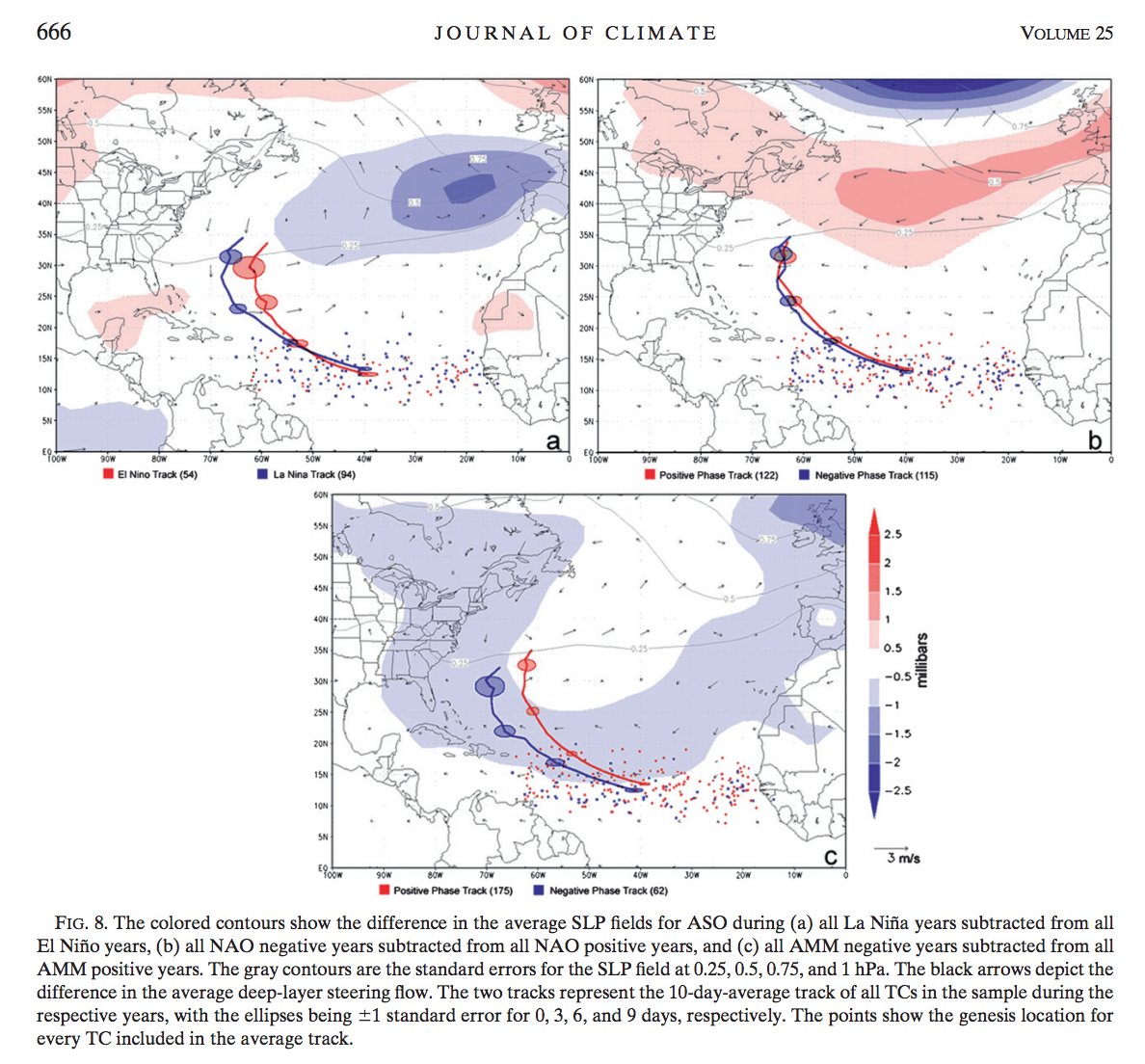
The AMM is usually a pretty good indicator of MDR activity and is the 2nd leading mode of variability in the Atlantic behind the AMO, to see it in record low territory is just another sign of a quiet season in terms of overall activity but it says little about the steering pattern. I'd also like to mention however that -AMO/-AMMs are actually more conducive to less recurving TCs out of the MDR because in order to get a -AMO/-AMM you need strong trades which also means you need a bigger AB high which would tend to steer TCs further west. Oth, the El Nino-ish atmosphere that's becomes well entrenched globally signals at least to me that there will be more troughs than normal attempting to emerge off the eastern seaboard to at least temporarily breakdown the AB high.

It's certainly an interesting lesser known observation amongst the met community and blogosphere that while you get significantly less storms in the MDR during -AMM/-AMOs, ones that do form are more likely to impact land. The ENSO steering pattern relationship is more widely recognized but is apparently just as important as the AMO/AMM.

 https://twitter.com/DanVimont/status/1013878561353207809


Image
2 likes   

User avatar
SFLcane
S2K Supporter
S2K Supporter
Posts: 9626
Age: 46
Joined: Sat Jun 05, 2010 1:44 pm
Location: Lake Worth Florida

Re: 2018 Indicators: SST's / MSLP / Sal / Steering / Shear / Instability (Graphic updates at first post)

#486 Postby SFLcane » Tue Jul 03, 2018 7:20 am

0 likes   

User avatar
TheStormExpert
Category 5
Category 5
Posts: 8487
Age: 30
Joined: Wed Feb 16, 2011 5:38 pm
Location: Palm Beach Gardens, FL

Re: 2018 Indicators: SST's / MSLP / Sal / Steering / Shear / Instability (Graphic updates at first post)

#487 Postby TheStormExpert » Tue Jul 03, 2018 7:41 am

:uarrow: With a warmer than average Subtropical Atlantic will it mean anything? Still could yeild somewhat more ideal conditions in the Tropical Atlantic but what I’ve noticed over the past several moths is you get these small warming blips only to cool back down for a long period.
0 likes   
The following post is NOT an official forecast and should not be used as such. It is just the opinion of the poster and may or may not be backed by sound meteorological data. It is NOT endorsed by storm2k.org.

User avatar
KWT
Category 5
Category 5
Posts: 31391
Joined: Tue Aug 17, 2004 11:02 am
Location: UK!!!

Re: 2018 Indicators: SST's / MSLP / Sal / Steering / Shear / Instability (Graphic updates at first post)

#488 Postby KWT » Tue Jul 03, 2018 11:02 am

I'm not buying that sst map, any map that has the water around Ireland/England cooling down as they have had record breaking warm temps is more than a little suspect..
1 likes   
Personal Forecast Disclaimer:
The posts in this forum are NOT official forecast and should not be used as such. They are just the opinion of the poster and may or may not be backed by sound meteorological data. They are NOT endorsed by any professional institution or storm2k.org. For official information, please refer to the NHC and NWS products

User avatar
Kingarabian
S2K Supporter
S2K Supporter
Posts: 15461
Joined: Sat Aug 08, 2009 3:06 am
Location: Honolulu, Hawaii

Re: 2018 Indicators: SST's / MSLP / Sal / Steering / Shear / Instability (Graphic updates at first post)

#489 Postby Kingarabian » Tue Jul 03, 2018 2:28 pm

KWT wrote:I'm not buying that sst map, any map that has the water around Ireland/England cooling down as they have had record breaking warm temps is more than a little suspect..


Agree. All the weather organizations in the world should get together, sit down, and agree on what SST climo to use. There's so much variance, that it's hard to know what's going on. That shouldn't be the case.
2 likes   
RIP Kobe Bryant

Ntxw
Storm2k Moderator
Storm2k Moderator
Posts: 21565
Joined: Wed Oct 21, 2009 6:34 pm
Location: DFW, Texas

Re: 2018 Indicators: SST's / MSLP / Sal / Steering / Shear / Instability (Graphic updates at first post)

#490 Postby Ntxw » Tue Jul 03, 2018 3:29 pm

That map is not actual sst map, but rather 7 day anomaly change.
4 likes   
The above post and any post by Ntxw is NOT an official forecast and should not be used as such. It is just the opinion of the poster and may or may not be backed by sound meteorological data. It is NOT endorsed by any professional institution including Storm2k. For official information, please refer to NWS products.

  Help support Storm2K!
Help Support Storm2K

User avatar
KWT
Category 5
Category 5
Posts: 31391
Joined: Tue Aug 17, 2004 11:02 am
Location: UK!!!

Re: 2018 Indicators: SST's / MSLP / Sal / Steering / Shear / Instability (Graphic updates at first post)

#491 Postby KWT » Tue Jul 03, 2018 4:31 pm

Ntxw wrote:That map is not actual sst map, but rather 7 day anomaly change.


Very true, still inaccurate for my neck of the woods though in a big way and obviously you can extralopate that to an extent. Record heat does not normally lead to ssts cooling..
Doesn't exactly give confidence to what it shows on abigger picture.
0 likes   
Personal Forecast Disclaimer:
The posts in this forum are NOT official forecast and should not be used as such. They are just the opinion of the poster and may or may not be backed by sound meteorological data. They are NOT endorsed by any professional institution or storm2k.org. For official information, please refer to the NHC and NWS products

Ntxw
Storm2k Moderator
Storm2k Moderator
Posts: 21565
Joined: Wed Oct 21, 2009 6:34 pm
Location: DFW, Texas

Re: 2018 Indicators: SST's / MSLP / Sal / Steering / Shear / Instability (Graphic updates at first post)

#492 Postby Ntxw » Tue Jul 03, 2018 4:42 pm

KWT wrote:
Ntxw wrote:That map is not actual sst map, but rather 7 day anomaly change.


Very true, still inaccurate for my neck of the woods though in a big way and obviously you can extralopate that to an extent. Record heat does not normally lead to ssts cooling..
Doesn't exactly give confidence to what it shows on abigger picture.


Cooling is misleading on that map. If it was record warmth and the past 7 days it cooled to really really warm, net cooling but still much warmer than average.
1 likes   
The above post and any post by Ntxw is NOT an official forecast and should not be used as such. It is just the opinion of the poster and may or may not be backed by sound meteorological data. It is NOT endorsed by any professional institution including Storm2k. For official information, please refer to NWS products.


  Help support Storm2K!

Help Support Storm2K


User avatar
StruThiO
Category 3
Category 3
Posts: 821
Age: 24
Joined: Fri Sep 15, 2017 5:51 am
Location: Currently Portland, OR. Raised in Jax, FL.

Re: 2018 Indicators: SST's / MSLP / Sal / Steering / Shear / Instability (Graphic updates at first post)

#493 Postby StruThiO » Thu Jul 05, 2018 11:39 am

0 likes   

User avatar
tarheelprogrammer
S2K Supporter
S2K Supporter
Posts: 1793
Joined: Mon Mar 28, 2016 9:25 pm
Location: Raleigh, NC area (Garner, NC)

Re: 2018 Indicators: SST's / MSLP / Sal / Steering / Shear / Instability (Graphic updates at first post)

#494 Postby tarheelprogrammer » Fri Jul 06, 2018 4:11 pm

African waves only seem to be getting stronger, not weaker. In inactive years, is it the opposite? Is there any documented cases of waves being this strong, but the season staying quiet? Just curious.

Image
2 likes   
My posts are not official forecasts. They are just my opinion and may or may not be backed by sound meteorological data. They are NOT endorsed by any professional institution or storm2k.org. For official information, please refer to the NHC and NWS products.

User avatar
Hammy
Category 5
Category 5
Posts: 5594
Age: 40
Joined: Fri May 25, 2012 5:25 pm
Contact:

Re: 2018 Indicators: SST's / MSLP / Sal / Steering / Shear / Instability (Graphic updates at first post)

#495 Postby Hammy » Fri Jul 06, 2018 4:28 pm

tarheelprogrammer wrote:African waves only seem to be getting stronger, not weaker. In inactive years, is it the opposite? Is there any documented cases of waves being this strong, but the season staying quiet? Just curious.


1997 is the only year that I can think of, where we had a lot of strong tropical waves coming off (including several almost-depressions) yet had a quiet season--but that year was being blasted with wind shear thanks to a record (at the time) Nino.
1 likes   
The above post is not official and should not be used as such. It is the opinion of the poster and may or may not be backed by sound meteorological data. It is not endorsed by any professional institution or storm2k.org. For official information, please refer to the NHC and NWS products.

User avatar
Siker
Category 4
Category 4
Posts: 904
Age: 27
Joined: Thu Oct 25, 2012 7:36 pm
Location: Miami, FL

Re: 2018 Indicators: SST's / MSLP / Sal / Steering / Shear / Instability (Graphic updates at first post)

#496 Postby Siker » Fri Jul 06, 2018 4:46 pm

Saw an interesting post over on Weather Underground yesterday that linked to this CPC page monitoring the "African InterTropical Front". Apparently the eastern portion of this has been at a record northern latitude recently. Here's the link and the most recent summary below:

http://www.cpc.ncep.noaa.gov/products/i ... itcz.shtml

Image

"From June 21-30, the ITF exhibited a large northward advancement in western Africa, and a significant advancement in eastern Africa during the end of June. The mean western (10W-10E) portion of the ITF was approximated at 18.2N, rising well above the climatological normal position by 1.6 degrees. The mean eastern (20E - 35E) portion of the ITF was approximated at 16.6N, very much above the climatological mean position (14.4N) by a remarkable 2.2 degrees. This latest eastern ITF portion anomaly is another significant jump northward from what was already a record postion for mid-June going back to the start of the ITF record in 1989. Figure 1 shows the current position of the ITF relative to the mean climatological (black) position during the 3rd dekad of June and its previous (yellow) position during the 2nd dekad of June. Figures 2 and 3 are time series, illustrating the mean latitudinal values of the western and eastern portion of the ITF, respectively, and their seasonal evolution compared to climatology since April, 2018."
3 likes   

User avatar
NotSparta
Professional-Met
Professional-Met
Posts: 1660
Age: 22
Joined: Fri Aug 18, 2017 8:24 am
Location: Naples, FL
Contact:

Re: 2018 Indicators: SST's / MSLP / Sal / Steering / Shear / Instability (Graphic updates at first post)

#497 Postby NotSparta » Fri Jul 06, 2018 4:52 pm

Siker wrote:Saw an interesting post over on Weather Underground yesterday that linked to this CPC page monitoring the "African InterTropical Front". Apparently the eastern portion of this has been at a record northern latitude recently. Here's the link and the most recent summary below:

http://www.cpc.ncep.noaa.gov/products/i ... itcz.shtml

[img]https://i.imgur.com/uWElcXW.jpg[img]

"From June 21-30, the ITF exhibited a large northward advancement in western Africa, and a significant advancement in eastern Africa during the end of June. The mean western (10W-10E) portion of the ITF was approximated at 18.2N, rising well above the climatological normal position by 1.6 degrees. The mean eastern (20E - 35E) portion of the ITF was approximated at 16.6N, very much above the climatological mean position (14.4N) by a remarkable 2.2 degrees. This latest eastern ITF portion anomaly is another significant jump northward from what was already a record postion for mid-June going back to the start of the ITF record in 1989. Figure 1 shows the current position of the ITF relative to the mean climatological (black) position during the 3rd dekad of June and its previous (yellow) position during the 2nd dekad of June. Figures 2 and 3 are time series, illustrating the mean latitudinal values of the western and eastern portion of the ITF, respectively, and their seasonal evolution compared to climatology since April, 2018."


But does it mean stronger waves?
0 likes   
This post was probably an opinion of mine, and in no way is official. Please refer to http://www.hurricanes.gov for official tropical analysis and advisories.

My website, with lots of tropical wx graphics, including satellite and recon: http://cyclonicwx.com

User avatar
TheStormExpert
Category 5
Category 5
Posts: 8487
Age: 30
Joined: Wed Feb 16, 2011 5:38 pm
Location: Palm Beach Gardens, FL

Re: 2018 Indicators: SST's / MSLP / Sal / Steering / Shear / Instability (Graphic updates at first post)

#498 Postby TheStormExpert » Fri Jul 06, 2018 5:30 pm

tarheelprogrammer wrote:African waves only seem to be getting stronger, not weaker. In inactive years, is it the opposite? Is there any documented cases of waves being this strong, but the season staying quiet? Just curious.

Image

Likely due to the Kelvin Wave passing by.
2 likes   
The following post is NOT an official forecast and should not be used as such. It is just the opinion of the poster and may or may not be backed by sound meteorological data. It is NOT endorsed by storm2k.org.

User avatar
cycloneye
Admin
Admin
Posts: 139593
Age: 67
Joined: Thu Oct 10, 2002 10:54 am
Location: San Juan, Puerto Rico

Re: 2018 Indicators: SST's / MSLP / Sal / Steering / Shear / Instability (Graphic updates at first post)

#499 Postby cycloneye » Sat Jul 07, 2018 8:57 am

Interesting thread on Twitter by Eric Webb.

@webberweather
Atlantic MDR may be cold now, but if the EPS monthly verifies w/ a quasi-stationary relaxed trade regime, the Atlantic MDR would warm up a lot going into Aug/Sep, putting some seasonal forecasts in trouble. This also has ENSO implications: a warmer Atlantic resists oncoming Ninos


 https://twitter.com/webberweather/status/1015592309109370882


 https://twitter.com/webberweather/status/1015592511996215297


@webberweather
We're clearly starting to move away from the pattern that made the Atlantic cold in the first place, just goes to show how difficult seasonal forecasting is. Even if the MDR warms a lot it doesn't automatically favor a very active season however given the subtropics are also warm


 https://twitter.com/webberweather/status/1015593879821692928


3 likes   
Visit the Caribbean-Central America Weather Thread where you can find at first post web cams,radars
and observations from Caribbean basin members Click Here

Eric Webb
Tropical Storm
Tropical Storm
Posts: 154
Joined: Fri Mar 13, 2015 10:42 pm
Contact:

Re: 2018 Indicators: SST's / MSLP / Sal / Steering / Shear / Instability (Graphic updates at first post)

#500 Postby Eric Webb » Sat Jul 07, 2018 9:26 am

cycloneye wrote:Interesting thread on Twitter by Eric Webb.

@webberweather
Atlantic MDR may be cold now, but if the EPS monthly verifies w/ a quasi-stationary relaxed trade regime, the Atlantic MDR would warm up a lot going into Aug/Sep, putting some seasonal forecasts in trouble. This also has ENSO implications: a warmer Atlantic resists oncoming Ninos


 https://twitter.com/webberweather/status/1015592309109370882


 https://twitter.com/webberweather/status/1015592511996215297


@webberweather
We're clearly starting to move away from the pattern that made the Atlantic cold in the first place, just goes to show how difficult seasonal forecasting is. Even if the MDR warms a lot it doesn't automatically favor a very active season however given the subtropics are also warm


 https://twitter.com/webberweather/status/1015593879821692928


Now keep in mind this is only showing the Equatorial Atlantic, I'm not entirely sure what the trades look like specifically in the 10-20N belt over the tropical Atlantic but this reduction in trades near the Equator has also coincided w/ the Atlantic warming over the past few weeks or so, it seems like we're going to keep this up going forward. It's a much different pattern than the one that led to the -AMO SST configuration over the Atlantic MDR.
3 likes   


Return to “Talkin' Tropics”

Who is online

Users browsing this forum: 7cardinal, Cpv17, Google Adsense [Bot], Ivanhater, kevin, Kingarabian, RomP, saila, SteveM, Tx_Summer and 90 guests