Tropical Wave in Bay of Campeche (Is Invest 91L)

This is the general tropical discussion area. Anyone can take their shot at predicting a storms path.

Moderator: S2k Moderators

Forum rules

The posts in this forum are NOT official forecasts and should not be used as such. They are just the opinion of the poster and may or may not be backed by sound meteorological data. They are NOT endorsed by any professional institution or STORM2K. For official information, please refer to products from the National Hurricane Center and National Weather Service.

Help Support Storm2K
Message
Author
IcyTundra
Category 5
Category 5
Posts: 1205
Joined: Mon Jun 07, 2021 9:32 pm
Location: Dickinson, Texas

Re: Tropical Wave in Central Atlantic (0/40)

#481 Postby IcyTundra » Fri Aug 30, 2024 6:37 pm

Stormlover70 wrote:
IcyTundra wrote:
hurricane2025 wrote:Bastardi said with mojo in phase 4 and 5 setup is like beryl


 https://x.com/BigJoeBastardi/status/1829606130043273346

A bold statement and with all due respect a bit of hype considering a storm hasn't even formed.


I was just showing the tweet that the poster was refering to.
1 likes   

User avatar
Hurricane2022
Category 5
Category 5
Posts: 1541
Joined: Tue Aug 23, 2022 11:38 pm
Location: Araçatuba, Brazil

Re: Tropical Wave in Central Atlantic (0/40)

#482 Postby Hurricane2022 » Fri Aug 30, 2024 6:44 pm

IcyTundra wrote:
hurricane2025 wrote:Bastardi said with mojo in phase 4 and 5 setup is like beryl


 https://x.com/BigJoeBastardi/status/1829606130043273346


Sorry but I can't see the post because X is banned from my country (temporarily i guess) because of political conflicts between Elon and the Supreme Court of Brazil :roll: :lol:
2 likes   
Sorry for the bad English sometimes...!
For reliable and detailed information for any meteorological phenomenon, please consult the National Hurricane Center, Joint Typhoon Warning Center , or your local Meteo Center.

--------

Una cvm Christo, pro Christo, et in Christo. Sit nomen Domini benedictvm.

User avatar
cycloneye
Admin
Admin
Posts: 145276
Age: 68
Joined: Thu Oct 10, 2002 10:54 am
Location: San Juan, Puerto Rico

Re: Tropical Wave in Central Atlantic (0/40)

#483 Postby cycloneye » Fri Aug 30, 2024 6:44 pm

Near the Lesser Antilles and Caribbean Sea:
Showers and thunderstorms associated with a tropical wave about a
thousand miles east of the Lesser Antilles remain disorganized.
Gradual development of this system is possible during the next few
days, and a tropical depression could form some time next week
while it moves westward, reaching the Lesser Antilles on Monday and
continuing across the Caribbean Sea through the middle to latter
part of the week.
* Formation chance through 48 hours...low...near 0 percent.
* Formation chance through 7 days...medium...40 percent.
0 likes   
Visit the Caribbean-Central America Weather Thread where you can find at first post web cams,radars
and observations from Caribbean basin members Click Here

IcyTundra
Category 5
Category 5
Posts: 1205
Joined: Mon Jun 07, 2021 9:32 pm
Location: Dickinson, Texas

Re: Tropical Wave in Central Atlantic (0/40)

#484 Postby IcyTundra » Fri Aug 30, 2024 6:47 pm

Hurricane2022 wrote:
IcyTundra wrote:
hurricane2025 wrote:Bastardi said with mojo in phase 4 and 5 setup is like beryl


 https://x.com/BigJoeBastardi/status/1829606130043273346


Sorry but I can't see the post because X is banned from my country (temporarily i guess) because of political conflicts between Elon and the Supreme Court of Brazil :roll: :lol:


Here is what thee tweet says.

With the MJO in phases 4/5 the next 10 days, despite models over the central and eastern gulf, like Beryl this could wind up in the correlation area which is the upper Texas gulf coast day 10-15

Image

Image
1 likes   

User avatar
SFLcane
S2K Supporter
S2K Supporter
Posts: 10163
Age: 47
Joined: Sat Jun 05, 2010 1:44 pm
Location: Lake Worth Florida

Re: Tropical Wave in Central Atlantic (0/40)

#485 Postby SFLcane » Fri Aug 30, 2024 6:59 pm

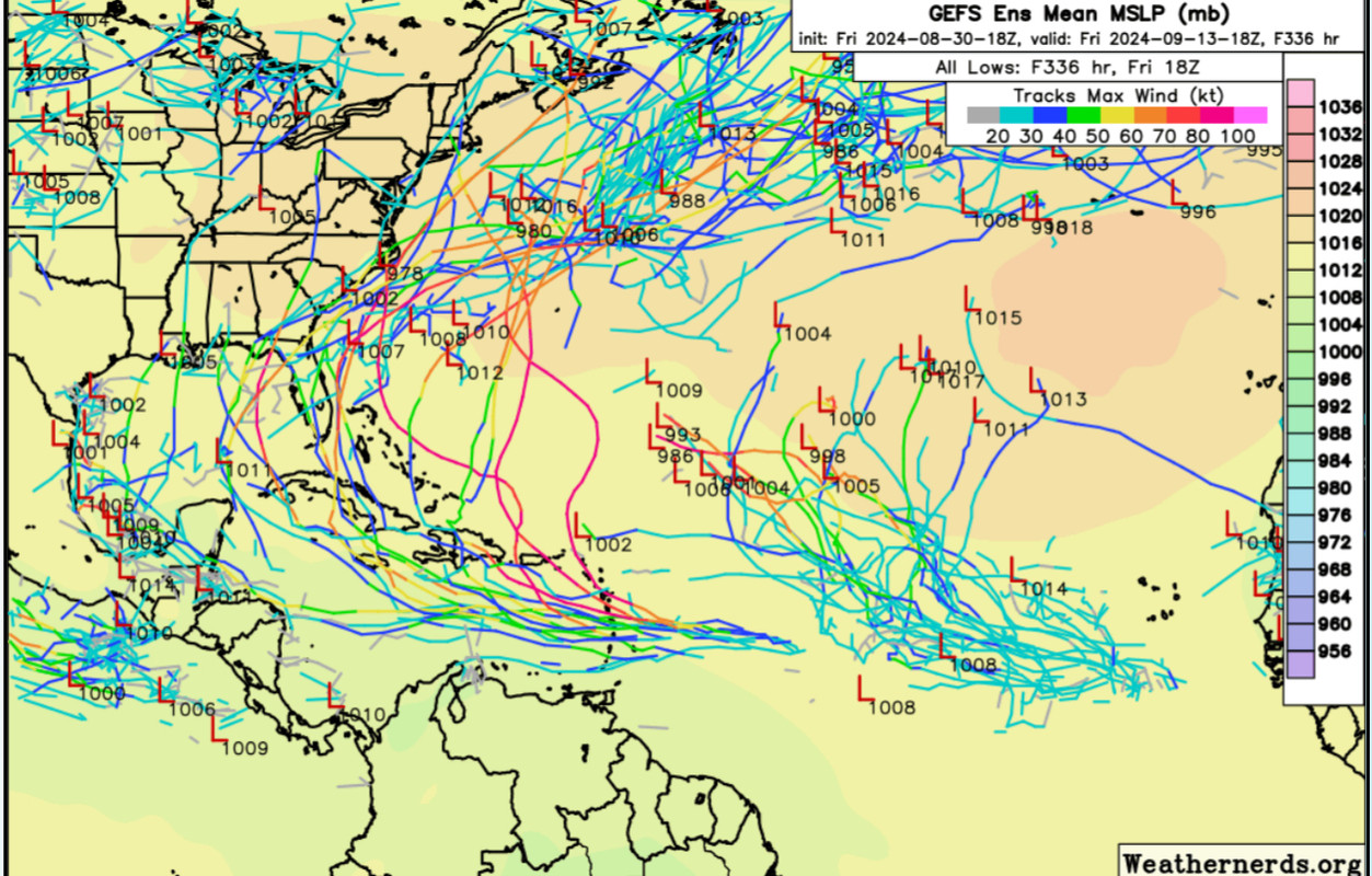
Gefs continues to be north of the operational with some quick recurves east of the Bahamas with most near FL.
1 likes   

Stormlover70
Tropical Storm
Tropical Storm
Posts: 175
Age: 55
Joined: Fri Jun 21, 2024 5:31 am
Location: New port richey

Re: Tropical Wave in Central Atlantic (0/40)

#486 Postby Stormlover70 » Fri Aug 30, 2024 7:05 pm

IcyTundra wrote:
Stormlover70 wrote:
A bold statement and with all due respect a bit of hype considering a storm hasn't even formed.


I was just showing the tweet that the poster was refering to.
oh. I know I was referring to him not you.
0 likes   

User avatar
CourierPR
Category 5
Category 5
Posts: 1335
Age: 71
Joined: Tue Aug 31, 2004 7:53 pm
Location: Pompano Beach, Florida

Re: Tropical Wave in Central Atlantic (0/40)

#487 Postby CourierPR » Fri Aug 30, 2024 7:10 pm

SFLcane wrote:Gefs continues to be north of the operational with some quick recurves east of the Bahamas with most near FL.


WPLG Miami Hurricane Specialist Michael Lowry alluded to this scenario this evening.
0 likes   

User avatar
cycloneye
Admin
Admin
Posts: 145276
Age: 68
Joined: Thu Oct 10, 2002 10:54 am
Location: San Juan, Puerto Rico

Re: Tropical Wave in Central Atlantic (0/40)

#488 Postby cycloneye » Fri Aug 30, 2024 7:14 pm

1 likes   
Visit the Caribbean-Central America Weather Thread where you can find at first post web cams,radars
and observations from Caribbean basin members Click Here

User avatar
Iceresistance
Category 5
Category 5
Posts: 9288
Age: 21
Joined: Sat Oct 10, 2020 9:45 am
Location: Tecumseh, OK/Norman, OK

Re: Tropical Wave in Central Atlantic (0/40)

#489 Postby Iceresistance » Fri Aug 30, 2024 7:32 pm

Frank P wrote:[url]https://i.ibb.co/99wxnvy/gfs-mslp-wind-eus-53.png [/url]
Probably made landfall below 940mb.

Well, here is your answer to that question, good lord.
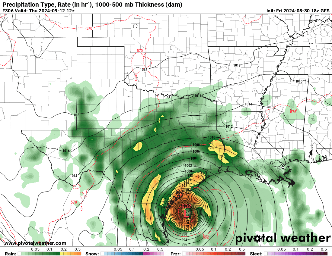
Image
https://s11.gifyu.com/images/Soofg.png
2 likes   
Bill 2015 & Beta 2020

Winter 2020-2021 :cold:

All observations are in Tecumseh, OK unless otherwise noted.

Winter posts are focused mainly for Oklahoma & Texas.

Take any of my forecasts with a grain of salt, refer to the NWS, SPC, and NHC for official information

Never say Never with weather! Because ANYTHING is possible!

MEANINGLESS_NUMBERS
Category 1
Category 1
Posts: 329
Joined: Mon Nov 02, 2020 1:43 pm

Re: Tropical Wave in Central Atlantic (0/40)

#490 Postby MEANINGLESS_NUMBERS » Fri Aug 30, 2024 7:56 pm

Models this time are year are always binary. Either they develop and the OHC bombs them into monsters or they don’t develop at all.
1 likes   
Emily '87, Felix '95, Gert '99, Fabian '03, Humberto '19, Paulette '20, Teddy '20, Fiona '22, Lee '23, Ernesto '24

User avatar
Blown Away
S2K Supporter
S2K Supporter
Posts: 10145
Joined: Wed May 26, 2004 6:17 am

Re: Tropical Wave in Central Atlantic (0/40)

#491 Postby Blown Away » Fri Aug 30, 2024 8:12 pm

Image

18z GEFS… This is what I call not in line with the operational run…
1 likes   
Hurricane Eye Experience: David 79, Irene 99, Frances 04, Jeanne 04, Wilma 05... EYE COMING MY WAY IN 2024…
Hurricane Brush Experience: Andrew 92, Erin 95, Floyd 99, Matthew 16, Irma 17, Ian 22, Nicole 22…

Stratton23
Category 5
Category 5
Posts: 2513
Joined: Fri Jul 21, 2023 10:59 pm
Location: Katy, Tx

Re: Tropical Wave in Central Atlantic (0/40)

#492 Postby Stratton23 » Fri Aug 30, 2024 8:27 pm

I will say, a recurve east of florida is starting to look more unlikely now, probably will be a CA or Gulf threat, the rudge over the atlantic is trending stronger
1 likes   

User avatar
Woofde
Category 1
Category 1
Posts: 479
Joined: Tue Jul 06, 2021 11:33 am

Re: Tropical Wave in Central Atlantic (0/40)

#493 Postby Woofde » Fri Aug 30, 2024 8:33 pm

Blown Away wrote:Image

18z GEFS… This is what I call not in line with the operational run…
After the Lesser Antilles the spread is from Central America all the way to Bermuda. That is about as much variance as you can get lol.
0 likes   

User avatar
SFLcane
S2K Supporter
S2K Supporter
Posts: 10163
Age: 47
Joined: Sat Jun 05, 2010 1:44 pm
Location: Lake Worth Florida

Re: Tropical Wave in Central Atlantic (0/40)

#494 Postby SFLcane » Fri Aug 30, 2024 8:36 pm

It’s best to stick to ensembles when you don’t have genesis yet. My take at least
2 likes   

User avatar
cycloneye
Admin
Admin
Posts: 145276
Age: 68
Joined: Thu Oct 10, 2002 10:54 am
Location: San Juan, Puerto Rico

Re: Tropical Wave in Central Atlantic (0/40)

#495 Postby cycloneye » Fri Aug 30, 2024 8:38 pm

SFLcane wrote:It’s best to stick to ensembles when you don’t have genesis yet. My take at least


I think Adrian, NHC folks do that and from them is how they go to the percents.
0 likes   
Visit the Caribbean-Central America Weather Thread where you can find at first post web cams,radars
and observations from Caribbean basin members Click Here

User avatar
SFLcane
S2K Supporter
S2K Supporter
Posts: 10163
Age: 47
Joined: Sat Jun 05, 2010 1:44 pm
Location: Lake Worth Florida

Re: Tropical Wave in Central Atlantic (0/40)

#496 Postby SFLcane » Fri Aug 30, 2024 8:51 pm

:eek:

Image
3 likes   

User avatar
Spacecoast
Category 2
Category 2
Posts: 758
Joined: Thu Aug 31, 2017 2:03 pm

Re: Tropical Wave in Central Atlantic (0/40)

#497 Postby Spacecoast » Fri Aug 30, 2024 8:52 pm

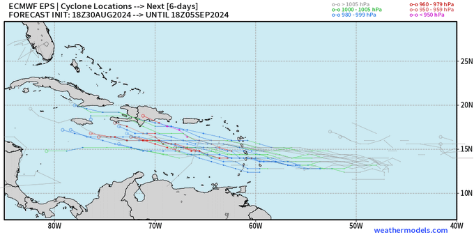
18z ECAI is back with Yucatan track. A bit further south of where it was previously favoring.
Continues through to S. BOC.
Image
0 likes   

User avatar
ROCK
Category 5
Category 5
Posts: 9484
Age: 54
Joined: Tue Aug 17, 2004 7:30 am
Location: Kemah, Texas

Re: Tropical Wave in Central Atlantic (0/40)

#498 Postby ROCK » Fri Aug 30, 2024 9:46 pm

18Z GFS is nasty :eek:
0 likes   

User avatar
wzrgirl1
S2K Supporter
S2K Supporter
Posts: 1325
Joined: Sat Sep 04, 2004 6:44 am
Location: Pembroke Pines, Florida

Re: Tropical Wave in Central Atlantic (0/40)

#499 Postby wzrgirl1 » Fri Aug 30, 2024 10:39 pm

ROCK wrote:18Z GFS is nasty :eek:


Gulp! Thank God it is still several days out.
0 likes   

TomballEd
Category 2
Category 2
Posts: 690
Age: 61
Joined: Wed Aug 16, 2023 4:52 pm
Location: Spring/Klein area, not Tomball

Re: Tropical Wave in Central Atlantic (0/40)

#500 Postby TomballEd » Fri Aug 30, 2024 10:47 pm

After 240 hours, the op GFS just becomes the best initialized ensemble It drops to ensemble resolution then. The next Cat 4 to hit Texas is an interesting map, but steering to me suggests (if it doesn't change), the E Gulf has a higher risk. Lets see if the 0Z GFS past the resolution truncation shows a different landfall. Those of you with PPV weather should be posting them already.

S2K glitchy, too many people locked in on a distant off hour GFS solution.
0 likes   


Return to “Talkin' Tropics”

Who is online

Users browsing this forum: LarryWx and 27 guests