ENSO Updates (2007 thru 2023)
Moderator: S2k Moderators
Forum rules

The posts in this forum are NOT official forecasts and should not be used as such. They are just the opinion of the poster and may or may not be backed by sound meteorological data. They are NOT endorsed by any professional institution or STORM2K. For official information, please refer to products from the National Hurricane Center and National Weather Service.
-
tolakram
- Admin

- Posts: 20185
- Age: 62
- Joined: Sun Aug 27, 2006 8:23 pm
- Location: Florence, KY (name is Mark)
Re: ENSO Updates
I don't think Waetherbells oiginal forecast of Modiki was motivated by anything other than best forecast available, but so far no el nino forecast, regardless of who made it, shows any skill over climatology. So we really don't know at this point.
0 likes
M a r k
- - - - -
Join us in chat: Storm2K Chatroom Invite. Android and IOS apps also available.
The posts in this forum are NOT official forecasts and should not be used as such. Posts are NOT endorsed by any professional institution or STORM2K.org. For official information and forecasts, please refer to NHC and NWS products.
-
gigabite

- S2K Supporter

- Posts: 916
- Age: 72
- Joined: Wed May 05, 2004 4:09 pm
- Location: Naples, Florida
Re: ENSO Updates
gigabite wrote:cycloneye wrote::uarrow: In simple words what that means for El Nino prospects?
There is a small correlation between the latitude of the New Moon and El Nino. At the July New Moon phase I would expect that the tidal budge would have a easterly movement. The duration of the event will not be long enough to describe an El Nino event, but it could help build warm pools. Accelerated evaporation should enhance cloud formations that would also move East which is contrary to my understanding of El Niño, because it should be a net positive SOI for the month.


As I updated the graph of "The New Moon's Latitude vs Negative SOI" I thought I would slap a trend-line on a cluster plot of the negative SOI and I came up with this. It seems to show a decreasing probability of future El Niño or at a detachment of the two metrics.
The updated "The New Moon's Latitude vs Negative SOI" has gone from some correlation to no correlation. Again proving that a correlation does not substantiate a relationship.
The data comes from http://www.bom.gov.au/climate/current/soihtm1.shtml
Last edited by gigabite on Mon Jul 21, 2014 3:25 pm, edited 1 time in total.
0 likes


Per the indices centered last week, Nino 3.4 cooled a little more to 0.2C while 1+2 warmed up to 1.5C. 3 had no change and 4 went up a little to 0.4
0 likes
The above post and any post by Ntxw is NOT an official forecast and should not be used as such. It is just the opinion of the poster and may or may not be backed by sound meteorological data. It is NOT endorsed by any professional institution including Storm2k. For official information, please refer to NWS products.
Help support Storm2K!
-
cycloneye

- Admin
- Posts: 149446
- Age: 69
- Joined: Thu Oct 10, 2002 10:54 am
- Location: San Juan, Puerto Rico
Re: ENSO Updates
Here is the text of the CPC Weekly update of 7/21/14 where Nino 3.4 is down to +0.2C.
http://www.cpc.ncep.noaa.gov/products/a ... ts-web.pdf
http://www.cpc.ncep.noaa.gov/products/a ... ts-web.pdf
0 likes
Visit the Caribbean-Central America Weather Thread where you can find at first post web cams,radars
and observations from Caribbean basin members Click Here
and observations from Caribbean basin members Click Here

-
xtyphooncyclonex

- Category 5

- Posts: 3891
- Age: 24
- Joined: Sat Dec 08, 2012 9:07 am
- Location: Cebu City
- Contact:
Strong El Niño Cancel? Well, an El Niño bust is unlikely IMO. I wonder if this would be a repeat of the 1986-87 event. The CFSv2 model is showing a moderate El Niño extending through March or April, and a less rapid weakening and sustained event.
0 likes
REMINDER: My opinions that I, or any other NON Pro-Met in this forum, are unofficial. Please do not take my opinions as an official forecast and warning. I am NOT a meteorologist. Following my forecasts blindly may lead to false alarm, danger and risk if official forecasts from agencies are ignored.
-
'CaneFreak

- Category 5
- Posts: 1487
- Joined: Mon Jun 05, 2006 10:50 am
- Location: New Bern, NC
Re:
That is what I am thinking as well. This is not your typical classical El Nino by any means. There are a lot of folks that have been fooled by this cooling trend in Nino 3.4 but I think that the warming trend will be back soon as evidenced by the current subsurface warming in the Western Pacific. I guess we should be clear though and say that an El Nino is not a complete deal breaker for Atlantic Basin TC fans but an early end to the Atlantic hurricane season is possible this year depending on how quickly the atmosphere responds to the changes in the ocean.
xtyphooncyclonex wrote:Strong El Niño Cancel? Well, an El Niño bust is unlikely IMO. I wonder if this would be a repeat of the 1986-87 event. The CFSv2 model is showing a moderate El Niño extending through March or April, and a less rapid weakening and sustained event.
0 likes
Re: Re:
'CaneFreak wrote:That is what I am thinking as well. This is not your typical classical El Nino by any means. There are a lot of folks that have been fooled by this cooling trend in Nino 3.4 but I think that the warming trend will be back soon as evidenced by the current subsurface warming in the Western Pacific. I guess we should be clear though and say that an El Nino is not a complete deal breaker for Atlantic Basin TC fans but an early end to the Atlantic hurricane season is possible this year depending on how quickly the atmosphere responds to the changes in the ocean.
Whatever happens also has repercussion for next year as well. If there is no El Nino, there won't likely be a La Nina. Especially if you are looking for something to change the Atlantic background state. If it is a weak Nino the odds become greater we stick to neutral again next year. Something needs to counter the balance. We haven't had a La Nina or El Nino since 2011. Neutrals don't go to La Nina, only another neutral or El Nino. La Nina's follow El Nino's or other Nina's. The bigger the Nino tends to produce later on bigger Nina's.
Source:
http://www.cpc.ncep.noaa.gov/products/a ... ears.shtml
0 likes
The above post and any post by Ntxw is NOT an official forecast and should not be used as such. It is just the opinion of the poster and may or may not be backed by sound meteorological data. It is NOT endorsed by any professional institution including Storm2k. For official information, please refer to NWS products.
Help support Storm2K!
Help support Storm2K!
-
WeatherEmperor
- S2K Supporter
- Posts: 4806
- Age: 42
- Joined: Thu Sep 04, 2003 2:54 pm
- Location: South Florida
Re: ENSO Updates
'CaneFreak wrote:That is what I am thinking as well. This is not your typical classical El Nino by any means. There are a lot of folks that have been fooled by this cooling trend in Nino 3.4 but I think that the warming trend will be back soon as evidenced by the current subsurface warming in the Western Pacific. I guess we should be clear though and say that an El Nino is not a complete deal breaker for Atlantic Basin TC fans but an early end to the Atlantic hurricane season is possible this year depending on how quickly the atmosphere responds to the changes in the ocean.xtyphooncyclonex wrote:Strong El Niño Cancel? Well, an El Niño bust is unlikely IMO. I wonder if this would be a repeat of the 1986-87 event. The CFSv2 model is showing a moderate El Niño extending through March or April, and a less rapid weakening and sustained event.
This is a good point because if el nino does form this year it might not be fully established during the peak of the atlantic season. It may establish toward the end near end sept or early oct which could mean an early end to the season. I just have a hard time seeing it fully established during late aug and early sept
Sent from my HTC EVO 4G LTE
0 likes
-
Yellow Evan

- Professional-Met

- Posts: 16240
- Age: 27
- Joined: Fri Jul 15, 2011 12:48 pm
- Location: Henderson, Nevada/Honolulu, HI
- Contact:
Re: ENSO Updates
WeatherEmperor wrote:'CaneFreak wrote:That is what I am thinking as well. This is not your typical classical El Nino by any means. There are a lot of folks that have been fooled by this cooling trend in Nino 3.4 but I think that the warming trend will be back soon as evidenced by the current subsurface warming in the Western Pacific. I guess we should be clear though and say that an El Nino is not a complete deal breaker for Atlantic Basin TC fans but an early end to the Atlantic hurricane season is possible this year depending on how quickly the atmosphere responds to the changes in the ocean.xtyphooncyclonex wrote:Strong El Niño Cancel? Well, an El Niño bust is unlikely IMO. I wonder if this would be a repeat of the 1986-87 event. The CFSv2 model is showing a moderate El Niño extending through March or April, and a less rapid weakening and sustained event.
This is a good point because if el nino does form this year it might not be fully established during the peak of the atlantic season. It may establish toward the end near end sept or early oct which could mean an early end to the season. I just have a hard time seeing it fully established during late aug and early sept
Sent from my HTC EVO 4G LTE
El Ninos are usually never peak until NHEM winter.
0 likes
-
xtyphooncyclonex
- Category 5
- Posts: 3891
- Age: 24
- Joined: Sat Dec 08, 2012 9:07 am
- Location: Cebu City
- Contact:
I think we will get a moderate strength, most models show it. I think it might be a long-lasting event which starts and ends late. Like, for example the 1986-88 event; but I am not saying that it would happen. You are open to disagree or comment.
0 likes
REMINDER: My opinions that I, or any other NON Pro-Met in this forum, are unofficial. Please do not take my opinions as an official forecast and warning. I am NOT a meteorologist. Following my forecasts blindly may lead to false alarm, danger and risk if official forecasts from agencies are ignored.
-
'CaneFreak
- Category 5
- Posts: 1487
- Joined: Mon Jun 05, 2006 10:50 am
- Location: New Bern, NC
Re: ENSO Updates
That pocket of 1 degree Celsius above normal water in the West Pacific at approximately 150-200 meters in depth is looking more and more like the begins of yet another downwelling phase of the Kelvin Wave. We shall see.

0 likes
-
euro6208
Re: ENSO Updates

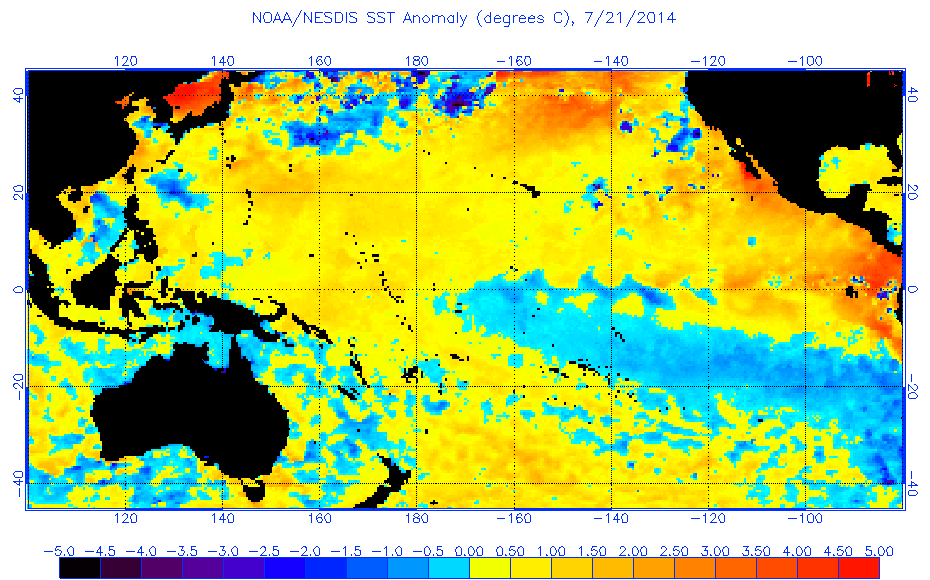
I do think a moderate el nino is still likely. The cooling right now is very normal for a developing el nino with an upwelling phrase (Cooler waters) but don't worry, a new downwelling phrase (Warmer waters) is likely starting right now with warming happening in the WPAC that should move east as shown in the graphics above. Thermocline is deepening...
0 likes
The volatility showing up on the Levi Cowan satellite based Nino 3.4 SST anomaly graph continues as it has dropped all of the way down to -0.217 as of 6Z today:
http://www.tropicaltidbits.com/analysis/nino34.png
http://www.tropicaltidbits.com/analysis/nino34.png
0 likes
Personal Forecast Disclaimer:
The posts in this forum are NOT official forecasts and should not be used as such. They are just the opinion of the poster and may or may not be backed by sound meteorological data. They are NOT endorsed by any professional institution or storm2k.org. For official information, please refer to the NHC and NWS products.
The posts in this forum are NOT official forecasts and should not be used as such. They are just the opinion of the poster and may or may not be backed by sound meteorological data. They are NOT endorsed by any professional institution or storm2k.org. For official information, please refer to the NHC and NWS products.
-
South Texas Storms

- Professional-Met
- Posts: 4258
- Joined: Thu Jun 24, 2010 12:28 am
- Location: Houston, TX
Re:
LarryWx wrote:The volatility showing up on the Levi Cowan satellite based Nino 3.4 SST anomaly graph continues as it has dropped all of the way down to -0.217 as of 6Z today:
http://www.tropicaltidbits.com/analysis/nino34.png
What are your thoughts on the SOI forecast through early August? I really enjoy your analysis on it based on the Euro forecast as it's usually pretty accurate.
0 likes

Something interesting I noticed with the upwelling chart, it seems to go in five month cycles, with each phase being stronger than the last, and if the trend continues it would be ~October when we're in a full El Nino (which I think a few others have pointed out as being the most likely scenario over the last few months with other data.)
0 likes
The above post is not official and should not be used as such. It is the opinion of the poster and may or may not be backed by sound meteorological data. It is not endorsed by any professional institution or storm2k.org. For official information, please refer to the NHC and NWS products.
-
gigabite
- S2K Supporter
- Posts: 916
- Age: 72
- Joined: Wed May 05, 2004 4:09 pm
- Location: Naples, Florida
Re: ENSO Updates
'CaneFreak wrote:That pocket of 1 degree Celsius above normal water in the West Pacific at approximately 150-200 meters in depth is looking more and more like the begins of yet another downwelling phase of the Kelvin Wave. We shall see.
I thought that Kelvin Waves were akin to Outbound Long Wave Radiation. Please enlighten me!!!
0 likes
-
gigabite
- S2K Supporter
- Posts: 916
- Age: 72
- Joined: Wed May 05, 2004 4:09 pm
- Location: Naples, Florida
Evidently El Niño amplitude varies. I think that maybe the ESNO phenomena is recycling. It might be 4 years or more of neutral.
https://www.vsp.ucar.edu/cgc/20thCelebr ... tavas-.pdf
https://www.vsp.ucar.edu/cgc/20thCelebr ... tavas-.pdf
0 likes
Re:
gigabite wrote:Evidently El Niño amplitude varies. I think that maybe the ESNO phenomena is recycling. It might be 4 years or more of neutral.
https://www.vsp.ucar.edu/cgc/20thCelebr ... tavas-.pdf
I think 4 years more is a little too much. It would be an unprecedented gap that's never seen before between ENSO events nonetheless El Nino. The earth has to release the heat energy eventually from the ocean, it's a constant push for balance an example would be in my earlier post about some of the strongest, longest Nina's are immediately after the big Nino's. If it does not happen this year (though I still believe we will get the Nino) it will within the next 2.
0 likes
The above post and any post by Ntxw is NOT an official forecast and should not be used as such. It is just the opinion of the poster and may or may not be backed by sound meteorological data. It is NOT endorsed by any professional institution including Storm2k. For official information, please refer to NWS products.
Help support Storm2K!
Help support Storm2K!
Who is online
Users browsing this forum: mixedDanilo.E, Stormybajan and 675 guests