Models Develop a Disturbance Near Florida (Is invest 90L)
Moderator: S2k Moderators
Forum rules

The posts in this forum are NOT official forecasts and should not be used as such. They are just the opinion of the poster and may or may not be backed by sound meteorological data. They are NOT endorsed by any professional institution or STORM2K. For official information, please refer to products from the National Hurricane Center and National Weather Service.
-
gatorcane

- S2K Supporter

- Posts: 23708
- Age: 48
- Joined: Sun Mar 13, 2005 3:54 pm
- Location: Boca Raton, FL
Re: Models Develop a Disturbance Near Florida This Week
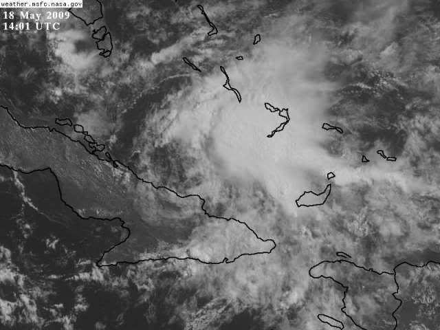
Evil Jeremy wrote:cycloneye wrote:You can see in loop a circulation at mid-levels on the northern Cuban coast.
http://www.ssd.noaa.gov/goes/flt/t1/flash-vis.html
I am surprised that there is a visible circulation after it just crossed Cuba lol.
since its mid-level, its above the mountains so no problem for it to pass through.
0 likes
-
HURAKAN

- Professional-Met

- Posts: 46084
- Age: 39
- Joined: Thu May 20, 2004 4:34 pm
- Location: Key West, FL
- Contact:
Re: Models Develop a Disturbance Near Florida This Week
Evil Jeremy wrote:cycloneye wrote:You can see in loop a circulation at mid-levels on the northern Cuban coast.
http://www.ssd.noaa.gov/goes/flt/t1/flash-vis.html
I am surprised that there is a visible circulation after it just crossed Cuba lol.
There was no LLC circulation, therefore, nothing was disrupted.
0 likes
-
Ed Mahmoud
Re: Models Develop a Disturbance Near Florida This Week
If I hadn't seen any models, my first guess for any kind of low development, be it not tropical at all at first, is somewhat West of Florida where Southern end of old front is convectively active. Might be a hint of low level circulation, mostly obscure by convection.
Although mostly I see Southerly flow on one side of the front and Northerly flow on the other.
Florida and vicinity loop.
The models, and the Cuba blob, of course, seem to suggest East of Florida.
Of course, cold air stratus forming as soon as the air hits the Gulf by Alabama would seem to confirm this has a long way to go as far as having tropical characteristics.
0 likes
-
Ed Mahmoud
Re: Models Develop a Disturbance Near Florida This Week
OK, visible loop does imply something trying to get going low level between Cuba and the Bahamas.
Unofficially, I am not at all sure what will develop, if anything.
Unofficially, I am not at all sure what will develop, if anything.
0 likes
-
Pearl River

- S2K Supporter
- Posts: 825
- Age: 67
- Joined: Fri Dec 09, 2005 6:07 pm
- Location: SELa
Re: Models Develop a Disturbance Near Florida This Week
54 F earlier at 7am cdt here in Pearl River and a N wind at 15mph. Just absolutely gorgeous this morning. I wish it could stay that way, but we do need some rain here too.
0 likes

Re: Models Develop a Disturbance Near Florida This Week
Ed Mahmoud wrote:If I hadn't seen any models, my first guess for any kind of low development, be it not tropical at all at first, is somewhat West of Florida where Southern end of old front is convectively active. Might be a hint of low level circulation, mostly obscure by convection.
Although mostly I see Southerly flow on one side of the front and Northerly flow on the other.
Florida and vicinity loop.
The models, and the Cuba blob, of course, seem to suggest East of Florida.
Of course, cold air stratus forming as soon as the air hits the Gulf by Alabama would seem to confirm this has a long way to go as far as having tropical characteristics.
I noticed what appears to be a bit of a spin offshore West Central Florida, too. The apparent rotation seems to be roughly centered south of a line from Panama City and west of a line from Sarasota, well offshore the Tampa Bay area. It's faintly visible on long range radar out of KTBW, too. I suspect this feature, if it's real, is some sort of a mid-level circulation that's possibly a convective remnant. The few surface buoy observations in the area don't seem to suggest much is there. I'd keep watching south in the Florida Straits area. This is where there seems to be a faint surface circulation (elongated a bit E-W near Key West from what I see), and is also roughly where the RUC/2 kicks-up circulation at H85 throughout the day.
- Jay
0 likes
-
gatorcane
- S2K Supporter
- Posts: 23708
- Age: 48
- Joined: Sun Mar 13, 2005 3:54 pm
- Location: Boca Raton, FL
Re: Models Develop a Disturbance Near Florida This Week
The 12Z NAM takes the low right over my area in Palm Beach County, FL in just 48 hours from now -- it would bring alot of much needed rain so I hope it verifies.
Below you can see the low has just passed West Palm Beach/Boca Raton corridor of Southern FL.
BTW - Has anybody noticed how consistent the NAM is in bringing this low into Southern FL?

Below you can see the low has just passed West Palm Beach/Boca Raton corridor of Southern FL.
BTW - Has anybody noticed how consistent the NAM is in bringing this low into Southern FL?
0 likes
Re: Models Develop a Disturbance Near Florida This Week
- Jay
0 likes
-
cycloneye

- Admin

- Posts: 149505
- Age: 69
- Joined: Thu Oct 10, 2002 10:54 am
- Location: San Juan, Puerto Rico
Re: Models Develop a Disturbance Near Florida This Week
In this loop you can see two rotations,one in the GOM and the one on the northern Cuban coast.
http://rammb.cira.colostate.edu/ramsdis ... _floater_1
http://rammb.cira.colostate.edu/ramsdis ... _floater_1
0 likes
-
hurricanefloyd5

- Category 5

- Posts: 1659
- Age: 45
- Joined: Sun May 02, 2004 10:53 am
- Location: Spartanburg
- Contact:
Re: Models Develop a Disturbance Near Florida This Week
Is there any reports from ships/bouys in the two areas reporting a surface low on either or just one of them??????
0 likes
-
srainhoutx

- S2K Supporter
- Posts: 6919
- Age: 68
- Joined: Sun Jan 14, 2007 11:34 am
- Location: Haywood County, NC
- Contact:
Re: Models Develop a Disturbance Near Florida This Week
Good disco from Key West this morning...snipet...
AREA FORECAST DISCUSSION FOR THE FLORIDA KEYS
NATIONAL WEATHER SERVICE KEY WEST FL
1054 AM EDT MON MAY 18 2009
.DISCUSSION...
LATEST GOES-12 MOISTURE CHANNEL ANIMATIONS SHOW A VIGOROUS SHORT-WAVE
TROUGH DIGGING OVER THE CENTRAL GULF OF MEXICO...INDUCING HEIGHT
FALLS AND SYNOPTIC-SCALE ASCENT OVER MUCH OF THE EASTERN GULF OF
MEXICO AND FLORIDA PENINSULA. IMAGES FROM THE VISIBLE CHANNEL SHOW
CONVECTION INITIATING READILY IN THESE AREAS. A SURFACE ANALYSIS
SHOWS A COLD FRONT HAVING PUSHED SOUTHWARD WELL INTO THE NORTHERN
GULF OF MEXICO...WITH 20-25KT NORTHERLIES DETECTED BY QUIKSCAT ALMOST
INTO THE CENTRAL GULF BASIN. MEANWHILE...MSL PRESSURES ARE SLOWLY
DROPPING IN THE VICINITY OF THE SOUTHEASTERN GULF AND FLORIDA KEYS. A
3MB DROP HAS OCCURRED AT KEY WEST DURING THE LAST 24 HOURS...AND A
BROAD AREA OF LOW PRESSURE APPEARS TO BE FORMING BETWEEN THE YUCATAN
CHANNEL AND THE EXTREME SOUTHEASTERN GULF OF MEXICO. AN UPPER-LEVEL
CYCLONE IS EVIDENT IN SATELLITE IMAGE LOOPS MOVING NORTHWARD FROM THE
WINDWARD PASSAGE/EASTERN CUBA TOWARD THE CENTRAL BAHAMAS. THIS SYSTEM
IS ASSOCIATED WITH A LOCAL INCREASE IN DEEP CUMULUS CONVECTION...WITH
OUTFLOW ARC CLOUDS PROPAGATING INTO THE DRIER AIR IN PLACE ACROSS
PORTIONS OF THE BAHAMAS...AS EVIDENCED BY THE 12Z NASSAU SOUNDING.
http://www.srh.noaa.gov/productview.php ... KEY&max=51
0 likes

Very interesting to see what happens in the end, its not totally unreasonable that two lows do eventually develop, one heading towards Florida and another west of Florida as well, we've seen it before where two systems can develop in such a set-up, though this time I'd be very surprised if that did happen.
0 likes

-
Aric Dunn
- Category 5
- Posts: 21238
- Age: 43
- Joined: Sun Sep 19, 2004 9:58 pm
- Location: Ready for the Chase.
- Contact:
Re: Models Develop a Disturbance Near Florida This Week
sorry, i have been looking for a better streamline image for the gulf but even in the image you can see the inverted V present in the SE gulf>
This is where the dynamics are for a low to form .. the area will still be sliding SE and should make it to the florida straits later today and maybe south east of FL. but it will likely close off a low most likely non tropical to hybrid and then maybe transition. as for the area near cuba STILL NOTING AT THE SURFACE just a mid level circ, although it could still work to the surface, in that case that may be more tropical and merge with the other low into a big mess of crap ..lol
anyway pay more attention to the florida straights off Key West later today. convection will begin to fire alot there very soon as forcing in the area is increasing fast as the sharp trough( inverted V) cloes off into a low and watch pressure in keywest and the buoys in the SE gulf for pressure falls
also my ealier image a couple pages back may be better than this image, if someone could find me a better streamline link as well .. I have lost a lot of my links this past year
0 likes
-
Aric Dunn
- Category 5
- Posts: 21238
- Age: 43
- Joined: Sun Sep 19, 2004 9:58 pm
- Location: Ready for the Chase.
- Contact:
Re: Models Develop a Disturbance Near Florida This Week
srainhoutx wrote:Good disco from Key West this morning...snipet...
AREA FORECAST DISCUSSION FOR THE FLORIDA KEYS
NATIONAL WEATHER SERVICE KEY WEST FL
1054 AM EDT MON MAY 18 2009
.DISCUSSION...
LATEST GOES-12 MOISTURE CHANNEL ANIMATIONS SHOW A VIGOROUS SHORT-WAVE
TROUGH DIGGING OVER THE CENTRAL GULF OF MEXICO...INDUCING HEIGHT
FALLS AND SYNOPTIC-SCALE ASCENT OVER MUCH OF THE EASTERN GULF OF
MEXICO AND FLORIDA PENINSULA. IMAGES FROM THE VISIBLE CHANNEL SHOW
CONVECTION INITIATING READILY IN THESE AREAS. A SURFACE ANALYSIS
SHOWS A COLD FRONT HAVING PUSHED SOUTHWARD WELL INTO THE NORTHERN
GULF OF MEXICO...WITH 20-25KT NORTHERLIES DETECTED BY QUIKSCAT ALMOST
INTO THE CENTRAL GULF BASIN. MEANWHILE...MSL PRESSURES ARE SLOWLY
DROPPING IN THE VICINITY OF THE SOUTHEASTERN GULF AND FLORIDA KEYS. A
3MB DROP HAS OCCURRED AT KEY WEST DURING THE LAST 24 HOURS...AND A
BROAD AREA OF LOW PRESSURE APPEARS TO BE FORMING BETWEEN THE YUCATAN
CHANNEL AND THE EXTREME SOUTHEASTERN GULF OF MEXICO. AN UPPER-LEVEL
CYCLONE IS EVIDENT IN SATELLITE IMAGE LOOPS MOVING NORTHWARD FROM THE
WINDWARD PASSAGE/EASTERN CUBA TOWARD THE CENTRAL BAHAMAS. THIS SYSTEM
IS ASSOCIATED WITH A LOCAL INCREASE IN DEEP CUMULUS CONVECTION...WITH
OUTFLOW ARC CLOUDS PROPAGATING INTO THE DRIER AIR IN PLACE ACROSS
PORTIONS OF THE BAHAMAS...AS EVIDENCED BY THE 12Z NASSAU SOUNDING.
http://www.srh.noaa.gov/productview.php ... KEY&max=51
hehe.. while i was typing my last post lol, thanks for posting that ..
0 likes
-
jlauderdal
- S2K Supporter
- Posts: 7240
- Joined: Wed May 19, 2004 5:46 am
- Location: NE Fort Lauderdale
- Contact:
Re: Models Develop a Disturbance Near Florida This Week
after two days of down the middle and waiting it appears they are prepared to take a position this afternoon
AREA FORECAST DISCUSSION
NATIONAL WEATHER SERVICE MIAMI FL
1032 AM EDT MON MAY 18 2009
UPDATE
ONLY MINOR CHANGES MADE TO THE FORECAST THIS MORNING. CURRENT
WATER VAPOR IMAGERY AND RUC ANALYSIS SHOWS STRONG MID LEVEL TROUGH
DIGGING THROUGH NERN GULF OF MEXICO. ASSOCIATED REMNANT WEAK
FRONTAL BOUNDARY IS STILL NORTH OF THE AREA...FROM JUST SOUTH OF
DAYTONA BEACH TO NEAR TAMPA. OTHER MID LEVEL CIRCULATION CONTINUES
NORTH OFF THE NORTH CENTRAL CUBA COAST THIS MORNING.
AHEAD OF THE GULF TROUGH AND FRONTAL BOUNDARY...A WARM/HUMID AND
UNCAPPED/UNSTABLE AIRMASS IS IN PLACE ACROSS THE REGION. SCATTERED
SHOWERS HAVE ALREADY DEVELOPED IN THIS AIRMASS THIS MORNING...AND
FEEL COVERAGE WILL INCREASE THIS AFTERNOON AS EXCELLENT UPPER
DIVERGENCE MOVES ACROSS THE AREA...AND WIDESPREAD GULF CONVECTION
APPROACHES WESTERN AREAS LATE. ONE QUESTION REMAINS HOW MUCH RAIN
WILL FALL ACROSS EAST COAST METRO AREAS DURING THE DAY TODAY...AS
2000FT DEEP SERLY LOW LEVEL FLOW WOULD ARGUE THAT MOST ACTIVITY
WOULD PUSH INLAND ON A DEVELOPING SEA BREEZE...BUT SUCH A PATTERN
IS FAVORABLE FOR SHOWERS TO MOVE ONSHORE FROM THE ATLANTIC AT JUST
ABOUT ANY TIME.
MORE DETAILS FOR TONIGHT/TUESDAY WILL BE PROVIDED THIS AFTERNOON
AFTER EXAMINING LATEST MODEL SUITE...BUT THREAT FOR HEAVY RAINFALL
AND WIDESPREAD CONVECTION APPEARS ON TRACK...HOWEVER MODEL
GUIDANCE DIFFERS STILL ON SUBTLE DETAILS WHICH COULD DETERMINE
JUST HOW MUCH RAIN FALLS AND WHERE.
FOR MARINE INTERESTS...WINDS SHOULD INCREASE SOME TONIGHT...BUT
OVER THE ATLANTIC WATERS THIS ALL DEPENDS ON HOW STRONG ANY SFC
LOW DEVELOPING SOUTH OF THE REGION CAN GET AND HOW MUCH THE
PRESSURE GRADIENT CAN INCREASE. HOWEVER...MOST GUIDANCE DOES AGREE
THAT SOME SORT OF LOWER LEVEL WIND SURGE WILL MOVE SOUTH ACROSS
THE NORTHERN GULF/LAKE OKEECHOBEE WATERS LATER TONIGHT...SO FOR
NOW HAVE INDICATED SMALL CRAFT ADVISORY MAY BE NEEDED FOR ALL ZONES
UNTIL DETAILS CAN BE FINE TUNED.
/STRASSBERG
0 likes
-
Evil Jeremy

- S2K Supporter
- Posts: 5463
- Age: 32
- Joined: Mon Apr 10, 2006 2:10 pm
- Location: Los Angeles, CA
-
gatorcane
- S2K Supporter
- Posts: 23708
- Age: 48
- Joined: Sun Mar 13, 2005 3:54 pm
- Location: Boca Raton, FL
Re:
Evil Jeremy wrote:The latest GFS moves this system much slower than before and seems to loose it around 72 hours. Very weak on this run.
Note it actually develops a surface low from the mid-level low North of Cuba, moves it NE, then weakens.
At the same time it develops a weak low near the FL Keys and then it goes poof and/or meets up with the surface low in the Bahamas..
Most of FL misses all of the good rain somehow with the mid-level system yanking it all into the Bahamas. This scenario is exactly what we would not want -- and what I was thinking could easily happen.
The cold front not this low, may actually be the best shot for rain across Southern FL with West-Central and North FL getting pounded at the moment. Link to radar image:
http://radar.weather.gov/ridge/radar.ph ... 11&loop=no
Let's see what happens after 84 hours...

Last edited by gatorcane on Mon May 18, 2009 11:12 am, edited 4 times in total.
0 likes
Who is online
Users browsing this forum: WaveBreaking and 271 guests