Wave WSW of CV Islands

This is the general tropical discussion area. Anyone can take their shot at predicting a storms path.

Moderator: S2k Moderators

Forum rules

The posts in this forum are NOT official forecasts and should not be used as such. They are just the opinion of the poster and may or may not be backed by sound meteorological data. They are NOT endorsed by any professional institution or STORM2K. For official information, please refer to products from the National Hurricane Center and National Weather Service.

Help Support Storm2K
Message
Author
User avatar
cycloneye
Admin
Admin
Posts: 145318
Age: 68
Joined: Thu Oct 10, 2002 10:54 am
Location: San Juan, Puerto Rico

Re: Wave WSW of CV Islands - Code Orange

#521 Postby cycloneye » Sat Jul 31, 2010 9:36 pm

knotimpaired wrote:We were just informed that my husbands ex-wife was diagnosed with stage four pancreatic cancer.

Please keep those fingers crossed.

:(


Sorry to hear that. My prayers go to her. Lets continue to discuss about the topic.
0 likes   
Visit the Caribbean-Central America Weather Thread where you can find at first post web cams,radars
and observations from Caribbean basin members Click Here

User avatar
TwisterFanatic
Category 5
Category 5
Posts: 1041
Joined: Mon Jun 28, 2010 12:43 pm
Location: Sallisaw, Oklahoma

Re: Wave WSW of CV Islands - Code Orange

#522 Postby TwisterFanatic » Sat Jul 31, 2010 9:44 pm

Image
0 likes   
Personal Forecast Disclaimer:
The posts in this forum are NOT official forecast and should not be used as such. They are just the opinion of the poster and may or may not be backed by sound meteorological data. They are NOT endorsed by any professional institution or storm2k.org. For official information, please refer to the NHC and NWS products.

User avatar
blp
Category 5
Category 5
Posts: 2840
Age: 46
Joined: Thu Sep 09, 2004 7:51 pm
Location: Miami, FL
Contact:

Re: Wave WSW of CV Islands - Code Orange

#523 Postby blp » Sat Jul 31, 2010 9:45 pm

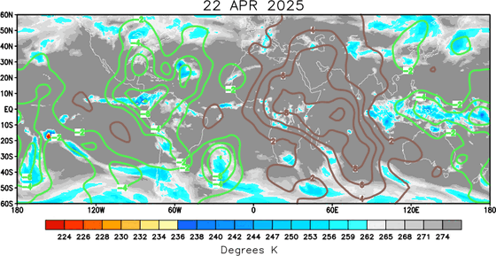
Greatest Vorticity is more north at 10. It looks like that flareup is mostly ITCZ induced. As others have stated this area is going to take its sweet time getting going.

Image
0 likes   

User avatar
caribepr
Category 5
Category 5
Posts: 1794
Joined: Fri Sep 05, 2003 10:43 pm
Location: Culebra, PR 18.33 65.33

Re: Re:

#524 Postby caribepr » Sat Jul 31, 2010 9:47 pm

cycloneye wrote:
caribepr wrote:Watching from Maine...


Wow, very far from your Culebra paradise Mj. Lets see what happens with this.


Yes, Luis, about 3000 miles or so ;) Once again grateful for S2K, so I can know what's going on
0 likes   

User avatar
MandiAltman
Tropical Low
Tropical Low
Posts: 12
Age: 48
Joined: Sun Jun 27, 2010 1:10 pm
Location: Myrtle Beach, SC

Re: Wave WSW of CV Islands - Code Orange

#525 Postby MandiAltman » Sat Jul 31, 2010 9:52 pm

About to sign off! Do y'all think this will be an invest when I get up in the morning?

G'night y'all!!
0 likes   
MANDI
Hugo, Bertha, Fran, Bonnie (1998), Floyd, Isabel, Charley

User avatar
lester
S2K Supporter
S2K Supporter
Posts: 1305
Age: 36
Joined: Sat Aug 27, 2005 5:21 pm
Location: Washington, DC
Contact:

#526 Postby lester » Sat Jul 31, 2010 9:53 pm

How this is not invested yet i'll never understand..
0 likes   

User avatar
funster
Category 3
Category 3
Posts: 816
Joined: Sat Dec 29, 2007 4:27 pm
Location: North Dallas

#527 Postby funster » Sat Jul 31, 2010 9:56 pm

Lots of convection there. I guess that's why the blob is so big. Maybe we will get an invest on Monday, after the weekend.
0 likes   

User avatar
cycloneye
Admin
Admin
Posts: 145318
Age: 68
Joined: Thu Oct 10, 2002 10:54 am
Location: San Juan, Puerto Rico

Re: Wave WSW of CV Islands - Code Orange

#528 Postby cycloneye » Sat Jul 31, 2010 10:02 pm

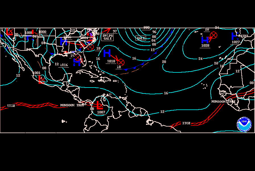
00z surface analysis.

Image
0 likes   
Visit the Caribbean-Central America Weather Thread where you can find at first post web cams,radars
and observations from Caribbean basin members Click Here

User avatar
blp
Category 5
Category 5
Posts: 2840
Age: 46
Joined: Thu Sep 09, 2004 7:51 pm
Location: Miami, FL
Contact:

Re: Wave WSW of CV Islands - Code Orange

#529 Postby blp » Sat Jul 31, 2010 10:10 pm

This should help our system. I guess its not so bad after all.

Image
0 likes   

User avatar
Recurve
Category 5
Category 5
Posts: 1640
Joined: Tue Aug 16, 2005 8:59 pm
Location: St. Petersburg, FL

#530 Postby Recurve » Sat Jul 31, 2010 10:25 pm

GFS is showing caribbean wave hitting Central America as a hurricane and the central Atlantic wave becoming a strong hurricane, clipping the northern antilles and making it to east of the Bahamas as a strong hurricane.

Image
Last edited by Recurve on Sat Jul 31, 2010 10:30 pm, edited 1 time in total.
0 likes   

User avatar
MGC
S2K Supporter
S2K Supporter
Posts: 5899
Joined: Sun Mar 23, 2003 9:05 pm
Location: Pass Christian MS, or what is left.

Re: Wave WSW of CV Islands - Code Orange

#531 Postby MGC » Sat Jul 31, 2010 10:28 pm

I don't see any cyclonic banding yet.....just looks like a bunch of thunderstorms in the ITCZ....I think 40% is rather generous......MGC
0 likes   

hurricaneCW
Category 5
Category 5
Posts: 1794
Joined: Wed Mar 03, 2010 6:20 am
Location: Toms River, NJ

Re: Wave WSW of CV Islands - Code Orange

#532 Postby hurricaneCW » Sat Jul 31, 2010 10:30 pm

MGC wrote:I don't see any cyclonic banding yet.....just looks like a bunch of thunderstorms in the ITCZ....I think 40% is rather generous......MGC


That may be true, but the coverage and the very cold cloud tops -80C, indicate something more than just a bunch of thunderstorms in the ITCZ. I think 40% is just fine.
0 likes   

User avatar
boca
Category 5
Category 5
Posts: 6367
Age: 60
Joined: Mon Dec 15, 2003 8:49 am
Location: Boca Raton,FL

Re: Wave WSW of CV Islands - Code Orange

#533 Postby boca » Sat Jul 31, 2010 10:32 pm

MGC wrote:I don't see any cyclonic banding yet.....just looks like a bunch of thunderstorms in the ITCZ....I think 40% is rather generous......MGC


I agree with you MGC its still part of the ITCZ and until it can separate itelf from the ITCZ it won't develop. It has to gain latitude.
0 likes   

User avatar
Recurve
Category 5
Category 5
Posts: 1640
Joined: Tue Aug 16, 2005 8:59 pm
Location: St. Petersburg, FL

Re: Wave WSW of CV Islands - Code Orange

#534 Postby Recurve » Sat Jul 31, 2010 10:34 pm

I could go either way. See your point MGC. ITCZ is active but this isn't anything yet.

Some of the models are bullish if they can be believed for development, showing a strong storm riding up past the Lesser Antilles to east of the Bahamas. I'm concerned about a strong ridge bridging at that point. It would be nice to track a monster that misses the islands, misses the Bahamas and finds a weakness to recurve into.
0 likes   

User avatar
gatorcane
S2K Supporter
S2K Supporter
Posts: 23691
Age: 47
Joined: Sun Mar 13, 2005 3:54 pm
Location: Boca Raton, FL

#535 Postby gatorcane » Sat Jul 31, 2010 10:36 pm

00Z GFS running....operational GFS initializes a 1009MB low at around 10N on the northern side of the huge blob...
Last edited by gatorcane on Sat Jul 31, 2010 10:37 pm, edited 1 time in total.
0 likes   

User avatar
boca
Category 5
Category 5
Posts: 6367
Age: 60
Joined: Mon Dec 15, 2003 8:49 am
Location: Boca Raton,FL

Re: Wave WSW of CV Islands - Code Orange

#536 Postby boca » Sat Jul 31, 2010 10:37 pm

Recurve wrote:I could go either way. See your point MGC. ITCZ is active but this isn't anything yet.

Some of the models are bullish if they can be believed for development, showing a strong storm riding up past the Lesser Antilles to east of the Bahamas. I'm concerned about a strong ridge bridging at that point. It would be nice to track a monster that misses the islands, misses the Bahamas and finds a weakness to recurve into.


Do the models show strong ridging at that point or is their a break between 2 high pressure areas by the bahamas?
0 likes   

User avatar
Riptide
Category 2
Category 2
Posts: 753
Age: 34
Joined: Fri Jul 23, 2010 3:33 pm
Location: Cape May, New Jersey
Contact:

Re: Wave WSW of CV Islands - Code Orange

#537 Postby Riptide » Sat Jul 31, 2010 10:37 pm

MGC wrote:I don't see any cyclonic banding yet.....just looks like a bunch of thunderstorms in the ITCZ....I think 40% is rather generous......MGC

There is still a surface trough and low pressure to the NW of the main convection, you can see it spinning and organizing in the black/white IR loop. It is now almost completely immersed under the convection and probably rapidly organizing. There wouldn't a be a low on the surface map without a reason. It is still trying to break away from the ITCZ though.
Last edited by Riptide on Sat Jul 31, 2010 10:38 pm, edited 1 time in total.
0 likes   

User avatar
gatorcane
S2K Supporter
S2K Supporter
Posts: 23691
Age: 47
Joined: Sun Mar 13, 2005 3:54 pm
Location: Boca Raton, FL

Re: Wave WSW of CV Islands - Code Orange

#538 Postby gatorcane » Sat Jul 31, 2010 10:38 pm

boca wrote:
Recurve wrote:I could go either way. See your point MGC. ITCZ is active but this isn't anything yet.

Some of the models are bullish if they can be believed for development, showing a strong storm riding up past the Lesser Antilles to east of the Bahamas. I'm concerned about a strong ridge bridging at that point. It would be nice to track a monster that misses the islands, misses the Bahamas and finds a weakness to recurve into.


Do the models show strong ridging at that point or is their a break between 2 high pressure areas by the bahamas?


ECMWF and GFS show strong ridging -- granted its over 7 days from now though...
0 likes   

User avatar
boca
Category 5
Category 5
Posts: 6367
Age: 60
Joined: Mon Dec 15, 2003 8:49 am
Location: Boca Raton,FL

Re: Wave WSW of CV Islands - Code Orange

#539 Postby boca » Sat Jul 31, 2010 10:39 pm

The 00GFS models runs are just coming out about now. At 12 hrs so far.
0 likes   

User avatar
gatorcane
S2K Supporter
S2K Supporter
Posts: 23691
Age: 47
Joined: Sun Mar 13, 2005 3:54 pm
Location: Boca Raton, FL

Re: Wave WSW of CV Islands - Code Orange

#540 Postby gatorcane » Sat Jul 31, 2010 10:40 pm

boca wrote:The 00GFS models runs are just coming out about now. At 12 hrs so far.


The 18Z was quite a scary run Boca for those in the Leewards, Bahamas, and Southern FL, let's see if it is similar or alot different. The 00Z has more data than the 18Z.
0 likes   


Return to “Talkin' Tropics”

Who is online

Users browsing this forum: Google Adsense [Bot], HurakaYoshi and 46 guests