
2021 Indicators: SST's / SAL / MSLP / Shear / Steering / Instability / Sat Images
Moderator: S2k Moderators
Forum rules

The posts in this forum are NOT official forecasts and should not be used as such. They are just the opinion of the poster and may or may not be backed by sound meteorological data. They are NOT endorsed by any professional institution or STORM2K. For official information, please refer to products from the National Hurricane Center and National Weather Service.
-
AutoPenalti
- Category 5

- Posts: 4091
- Age: 29
- Joined: Mon Aug 17, 2015 4:16 pm
- Location: Ft. Lauderdale, Florida
Re: 2021 Indicators: SST's / SAL / MSLP / Shear / Steering / Instability / Sat Images
9 likes
The posts in this forum are NOT official forecasts and should not be used as such. They are just the opinion of the poster and may or may not be backed by sound meteorological data. They are NOT endorsed by any professional institution or STORM2K. For official information, please refer to products from the NHC and NWS.
Model Runs Cheat Sheet:
GFS (5:30 AM/PM, 11:30 AM/PM)
HWRF, GFDL, UKMET, NAVGEM (6:30-8:00 AM/PM, 12:30-2:00 AM/PM)
ECMWF (1:45 AM/PM)
TCVN is a weighted averaged
-
SFLcane

- S2K Supporter

- Posts: 10281
- Age: 48
- Joined: Sat Jun 05, 2010 1:44 pm
- Location: Lake Worth Florida
Re: 2021 Indicators: SST's / SAL / MSLP / Shear / Steering / Instability / Sat Images
AutoPenalti wrote:https://i.imgur.com/S7x7Qqv.gif
Interesting... Little ITCZ disturbance aided by the CCKW. It'll be dead in a day
0 likes
-
Category5Kaiju

- Category 5
- Posts: 4334
- Joined: Thu Dec 24, 2020 12:45 pm
- Location: Seattle and Phoenix
Re: 2021 Indicators: SST's / SAL / MSLP / Shear / Steering / Instability / Sat Images
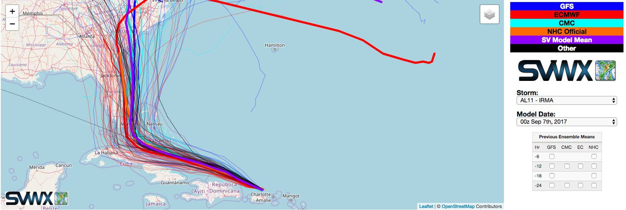
Nuno wrote:Shell Mound wrote:SFLcane wrote:Great informative video of potential steering this season. Florida
https://youtu.be/fiskrbHUuxc
https://i.postimg.cc/brXmwt4m/20177-Sept-Irma-79.png
https://i.postimg.cc/43S8jMPk/20177-Sept-Irma-82.jpg
As far as steering is concerned, based on the possible location and track of soon-to-be STS Ana, perhaps this season will be a blend of 1999 and 2017. The mean of Floyd (1999) and Irma (2017) would place storms curving into Southeast Florida, similarly to the early model runs that took Irma into Miami. The somewhat reliable EC suggests a reduced frequency of ≥ 45-kt wind gusts from North Carolina to New England during the peak trimonthly period of ASO, so perhaps it is hinting at a blocking ridge over the Mid-Atlantic that acts to keep storms confined farther south, suggesting more of a threat to peninsular Florida vs. points east (Outer Banks) and west (Gulf).
Blending 1999 and 2017 wouldn't be too far off from the ECMWF C3S forecast posted earlier for ASO. I worry for the Bahamas this season especially. Tracks over the Bahamas or so close to SE FL could result in OBX brushes too, though there weren't any in 2017.
I really hope Grand Abaco and Freeport don't get hit by a strong hurricane this year, Dorian was horrible enough.
0 likes
Unless explicitly stated, all info in my posts is based on my own opinions and observations. Tropical storms and hurricanes can be extremely dangerous. Refer to an accredited weather research agency or meteorologist if you need to make serious decisions regarding an approaching storm.
-
Shell Mound
- Category 5
- Posts: 2432
- Age: 33
- Joined: Thu Sep 07, 2017 3:39 pm
- Location: St. Petersburg, FL → Scandinavia
Re: 2021 Indicators: SST's / SAL / MSLP / Shear / Steering / Instability / Sat Images
Nuno wrote:Shell Mound wrote:SFLcane wrote:Great informative video of potential steering this season. Florida
https://youtu.be/fiskrbHUuxc
https://i.postimg.cc/brXmwt4m/20177-Sept-Irma-79.png
https://i.postimg.cc/43S8jMPk/20177-Sept-Irma-82.jpg
As far as steering is concerned, based on the possible location and track of soon-to-be STS Ana, perhaps this season will be a blend of 1999 and 2017. The mean of Floyd (1999) and Irma (2017) would place storms curving into Southeast Florida, similarly to the early model runs that took Irma into Miami. The somewhat reliable EC suggests a reduced frequency of ≥ 45-kt wind gusts from North Carolina to New England during the peak trimonthly period of ASO, so perhaps it is hinting at a blocking ridge over the Mid-Atlantic that acts to keep storms confined farther south, suggesting more of a threat to peninsular Florida vs. points east (Outer Banks) and west (Gulf).
Blending 1999 and 2017 wouldn't be too far off from the ECMWF C3S forecast posted earlier for ASO. I worry for the Bahamas this season especially. Tracks over the Bahamas or so close to SE FL could result in OBX brushes too, though there weren't any in 2017.
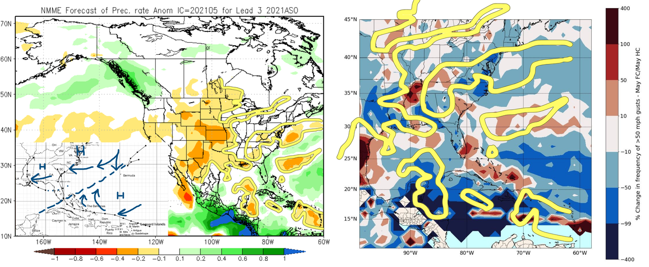
Wind and precipitation patterns relative to expected conditions suggest that the EC and the NMME are in rather decent agreement on ASO.
Last edited by Shell Mound on Tue May 25, 2021 9:53 am, edited 1 time in total.
1 likes
CVW / MiamiensisWx / Shell Mound
The posts in this forum are NOT official forecasts and should not be used as such. They are just the opinion of the poster and may or may not be backed by sound meteorological data. They are NOT endorsed by any professional institution or STORM2K. For official information, please refer to products from the NHC and NWS.
-
cycloneye

- Admin

- Posts: 149508
- Age: 69
- Joined: Thu Oct 10, 2002 10:54 am
- Location: San Juan, Puerto Rico
Re: 2021 Indicators: SST's / SAL / MSLP / Shear / Steering / Instability / Sat Images
At this rate 2021 may reach 30. 
1 likes
Visit the Caribbean-Central America Weather Thread where you can find at first post web cams,radars
and observations from Caribbean basin members Click Here
and observations from Caribbean basin members Click Here

Re: 2021 Indicators: SST's / SAL / MSLP / Shear / Steering / Instability / Sat Images
cycloneye wrote:At this rate 2021 may reach 30.
If we have Ana and Bill active at the same time tomorrow or Saturday...yeah that’s a possibility lol.
I’m interested to see if the potentially favorable CAG setup for mid to late June could produce something moderately significant, like at least a moderate TS, maybe even a hurricane. June hurricanes certainly aren’t impossible, and this part of the Caribbean has the highest SSTs in the basin this early in the season.
0 likes
Irene '11 Sandy '12 Hermine '16 5/15/2018 Derecho Fay '20 Isaias '20 Elsa '21 Henri '21 Ida '21
I am only a meteorology enthusiast who knows a decent amount about tropical cyclones. Look to the professional mets, the NHC, or your local weather office for the best information.
I am only a meteorology enthusiast who knows a decent amount about tropical cyclones. Look to the professional mets, the NHC, or your local weather office for the best information.
-
DorkyMcDorkface

- Category 5
- Posts: 1018
- Age: 28
- Joined: Mon Sep 30, 2019 1:32 pm
- Location: Mid-Atlantic
Re: 2021 Indicators: SST's / SAL / MSLP / Shear / Steering / Instability / Sat Images
Ah, yes, May...

7 likes
Please note the thoughts expressed by this account are solely those of the user and are from a hobbyist perspective. For more comprehensive analysis, consult an actual professional meteorologist or meteorological agency.
Floyd 1999 | Isabel 2003 | Hanna 2008 | Irene 2011 | Sandy 2012 | Isaias 2020
-
SconnieCane
- Category 5
- Posts: 1013
- Joined: Thu Aug 02, 2018 5:29 pm
- Location: Madison, WI
Re: 2021 Indicators: SST's / SAL / MSLP / Shear / Steering / Instability / Sat Images
I'm just hoping whatever's in the Gulf landfalls/dissipates quickly so it doesn't muck up moisture return for any potential land-based severe weather setups next week. May (in theory) is to tornadoes what September is to Atlantic hurricanes, and so far this one has been awfully quiet.
0 likes
-
JetFuel_SE

- Category 1

- Posts: 287
- Age: 26
- Joined: Thu Apr 30, 2020 3:57 pm
Re: 2021 Indicators: SST's / SAL / MSLP / Shear / Steering / Instability / Sat Images
SconnieCane wrote:I'm just hoping whatever's in the Gulf landfalls/dissipates quickly so it doesn't muck up moisture return for any potential land-based severe weather setups next week. May (in theory) is to tornadoes what September is to Atlantic hurricanes, and so far this one has been awfully quiet.
I'd much rather have a TD or weak TS hit Texas instead. A severe weather outbreak will likely do much more damage than a weak TS.
0 likes
Re: 2021 Indicators: SST's / SAL / MSLP / Shear / Steering / Instability / Sat Images
The fact that we’re watching two simultaneous invests with LLCs on the verge of becoming S/TCs in late May during an unfavorable MJO phase is really saying something. Looks like the Atlantic base state is favorable like last year. I’m still not expecting over 20 storms this season, but if this is a sign of things to come, we’re gonna be in for a looooong ride...
6 likes
Irene '11 Sandy '12 Hermine '16 5/15/2018 Derecho Fay '20 Isaias '20 Elsa '21 Henri '21 Ida '21
I am only a meteorology enthusiast who knows a decent amount about tropical cyclones. Look to the professional mets, the NHC, or your local weather office for the best information.
I am only a meteorology enthusiast who knows a decent amount about tropical cyclones. Look to the professional mets, the NHC, or your local weather office for the best information.
-
cycloneye
- Admin
- Posts: 149508
- Age: 69
- Joined: Thu Oct 10, 2002 10:54 am
- Location: San Juan, Puerto Rico
Re: 2021 Indicators: SST's / SAL / MSLP / Shear / Steering / Instability / Sat Images
This is very interesting about how a strong West African Monsoon affects ENSO.
https://twitter.com/webberweather/status/1395908201489473539
https://twitter.com/webberweather/status/1395908201489473539
0 likes
Visit the Caribbean-Central America Weather Thread where you can find at first post web cams,radars
and observations from Caribbean basin members Click Here
and observations from Caribbean basin members Click Here
-
Shell Mound
- Category 5
- Posts: 2432
- Age: 33
- Joined: Thu Sep 07, 2017 3:39 pm
- Location: St. Petersburg, FL → Scandinavia
Re: 2021 Indicators: SST's / SAL / MSLP / Shear / Steering / Instability / Sat Images
SFLcane wrote:Say goodbye to your cool MDR per the CFS the switch is about to Flip. I do not have a weatherbell account to view the CFS daily but i was able to grab a screen shot of June26 via youtube. Check out those anomalies off the african coast! There is a hole there its do to the way its display but if it weren't there i'd bet you would have yourself an above average basin.
This is June 26th... we shall see in a few weeks if it verifies.
https://i.imgur.com/X4V4jzk.png
So far SST in the MDR have remained steady over the past week and a half, despite prolonged laxity of trades, so this forecast is likely to bust significantly.
As an aside, Ana’s track has been/is very similar to Arlene’s (1999). If so, I’m expecting more of a threat to the Carolinas than South Florida during ASO.
0 likes
CVW / MiamiensisWx / Shell Mound
The posts in this forum are NOT official forecasts and should not be used as such. They are just the opinion of the poster and may or may not be backed by sound meteorological data. They are NOT endorsed by any professional institution or STORM2K. For official information, please refer to products from the NHC and NWS.
-
toad strangler

- S2K Supporter
- Posts: 4546
- Joined: Sun Jul 28, 2013 3:09 pm
- Location: Earth
- Contact:
Re: 2021 Indicators: SST's / SAL / MSLP / Shear / Steering / Instability / Sat Images
Shell Mound wrote:SFLcane wrote:Say goodbye to your cool MDR per the CFS the switch is about to Flip. I do not have a weatherbell account to view the CFS daily but i was able to grab a screen shot of June26 via youtube. Check out those anomalies off the african coast! There is a hole there its do to the way its display but if it weren't there i'd bet you would have yourself an above average basin.
This is June 26th... we shall see in a few weeks if it verifies.
https://i.imgur.com/X4V4jzk.png
So far SST in the MDR have remained steady over the past week and a half, despite prolonged laxity of trades, so this forecast is likely to bust significantly.
As an aside, Ana’s track has been/is very similar to Arlene’s (1999). If so, I’m expecting more of a threat to the Carolinas than South Florida during ASO.
Remember last year when you had Laura re-curving E of FL a few days out? She landfalled in LA narrowly missing a E TX landfall. Future tracks post 72 hours and many times less than that are the great unknown along with intensity forecasts. I for one wouldn't ever hang my ASO hat on what a current season early storm does in comparison to a individual storm from a analog year. Analogs are for comparing background states and individual basin indicators. Not tracks IMO. Now, the SST watch is a viable one if you are searching that hard but it's not even June 1 yet. Too early to bang that drum loud as the SAL hand wringers learned last year.
9 likes
My Weather Station
https://www.wunderground.com/dashboard/pws/KFLPORTS603
https://www.wunderground.com/dashboard/pws/KFLPORTS603
-
Category5Kaiju
- Category 5
- Posts: 4334
- Joined: Thu Dec 24, 2020 12:45 pm
- Location: Seattle and Phoenix
Re: 2021 Indicators: SST's / SAL / MSLP / Shear / Steering / Instability / Sat Images
cycloneye wrote:This is very interesting about how a strong West African Monsoon affects ENSO.
https://twitter.com/webberweather/status/1395908201489473539
Oh my gosh, I have been theorizing something similar to this for a while. I would be very curious to see if a strong WAM occurs next year as aside from that there are potential signs that an El Niño could occur next year
2 likes
Unless explicitly stated, all info in my posts is based on my own opinions and observations. Tropical storms and hurricanes can be extremely dangerous. Refer to an accredited weather research agency or meteorologist if you need to make serious decisions regarding an approaching storm.
-
SFLcane
- S2K Supporter
- Posts: 10281
- Age: 48
- Joined: Sat Jun 05, 2010 1:44 pm
- Location: Lake Worth Florida
Re: 2021 Indicators: SST's / SAL / MSLP / Shear / Steering / Instability / Sat Images
subtropical warmth heading southward into the main development region. Give it a few weeks
https://twitter.com/cyclonicwx/status/1396203684497854469
https://twitter.com/cyclonicwx/status/1396203684497854469
1 likes
-
cycloneye
- Admin
- Posts: 149508
- Age: 69
- Joined: Thu Oct 10, 2002 10:54 am
- Location: San Juan, Puerto Rico
Re: 2021 Indicators: SST's / SAL / MSLP / Shear / Steering / Instability / Sat Images
SFLcane wrote:subtropical warmth heading southward into the main development region. Give it a few weeks
https://twitter.com/cyclonicwx/status/1 ... 4497854469
Interesting that shift but time will tell the real story.
1 likes
Visit the Caribbean-Central America Weather Thread where you can find at first post web cams,radars
and observations from Caribbean basin members Click Here
and observations from Caribbean basin members Click Here
Re: 2021 Indicators: SST's / SAL / MSLP / Shear / Steering / Instability / Sat Images
I seen on the news there was a big solar flare this week that could cause communication problems. In 2017 before Irma there was heavy solar activity. Is there a correlation between solar storms and hurricanes?
0 likes
-
Category5Kaiju
- Category 5
- Posts: 4334
- Joined: Thu Dec 24, 2020 12:45 pm
- Location: Seattle and Phoenix
Re: 2021 Indicators: SST's / SAL / MSLP / Shear / Steering / Instability / Sat Images
St0rmTh0r wrote:I seen on the news there was a big solar flare this week that could cause communication problems. In 2017 before Irma there was heavy solar activity. Is there a correlation between solar storms and hurricanes?
I highly doubt it. If stronger solar flares are somewhat correlated with stronger hurricanes, then was there heavy solar flare activity before storms like Gilbert, Katrina, Dorian, Ivan, Andrew, or Mitch? I would love to know
0 likes
Unless explicitly stated, all info in my posts is based on my own opinions and observations. Tropical storms and hurricanes can be extremely dangerous. Refer to an accredited weather research agency or meteorologist if you need to make serious decisions regarding an approaching storm.


Re: 2021 Indicators: SST's / SAL / MSLP / Shear / Steering / Instability / Sat Images
St0rmTh0r wrote:I seen on the news there was a big solar flare this week that could cause communication problems. In 2017 before Irma there was heavy solar activity. Is there a correlation between solar storms and hurricanes?
Was wondering the same thing. I remember maybe it was Joe Bastardi taking about low solar flare activity and lack of activity in the tropics several years ago in a video. Could be some correlation. We shall see if this active solar trend continues this year.
0 likes
Who is online
Users browsing this forum: No registered users and 245 guests