2018 EPAC Season

This is the general tropical discussion area. Anyone can take their shot at predicting a storms path.

Moderator: S2k Moderators

Forum rules

The posts in this forum are NOT official forecasts and should not be used as such. They are just the opinion of the poster and may or may not be backed by sound meteorological data. They are NOT endorsed by any professional institution or STORM2K. For official information, please refer to products from the National Hurricane Center and National Weather Service.

Help Support Storm2K
Message
Author
User avatar
cycloneye
Admin
Admin
Posts: 139593
Age: 67
Joined: Thu Oct 10, 2002 10:54 am
Location: San Juan, Puerto Rico

Re: 2018 EPAC Season

#541 Postby cycloneye » Tue Jun 26, 2018 5:56 pm

Kingarabian wrote:18z GFS through 240 hours back to showing Emilia stronger, Fabio a potent cat.4 hurricane, and eventually Gilma a potent cat.4 hurricane.

GFS and the Euro have been all over the place in regards to steering. Being that these next 3 named systems will be forming this week and next week, SST's to the north still need some more time to be ideal to harbor major hurricanes.

We're also at the stage where steering is shifting from recurving closer to Mexico to pushing systems west closer to the CPAC.


Again GFS has at the end Hector.
0 likes   
Visit the Caribbean-Central America Weather Thread where you can find at first post web cams,radars
and observations from Caribbean basin members Click Here

User avatar
Kingarabian
S2K Supporter
S2K Supporter
Posts: 15461
Joined: Sat Aug 08, 2009 3:06 am
Location: Honolulu, Hawaii

Re: 2018 EPAC Season

#542 Postby Kingarabian » Tue Jun 26, 2018 6:04 pm

cycloneye wrote:
Kingarabian wrote:18z GFS through 240 hours back to showing Emilia stronger, Fabio a potent cat.4 hurricane, and eventually Gilma a potent cat.4 hurricane.

GFS and the Euro have been all over the place in regards to steering. Being that these next 3 named systems will be forming this week and next week, SST's to the north still need some more time to be ideal to harbor major hurricanes.

We're also at the stage where steering is shifting from recurving closer to Mexico to pushing systems west closer to the CPAC.


Again GFS has at the end Hector.


18z GFS also looks like it has Ileana somewhere in between.
2 likes   
RIP Kobe Bryant

User avatar
cycloneye
Admin
Admin
Posts: 139593
Age: 67
Joined: Thu Oct 10, 2002 10:54 am
Location: San Juan, Puerto Rico

Re: 2018 EPAC Season

#543 Postby cycloneye » Tue Jun 26, 2018 6:06 pm

cycloneye wrote:
Kingarabian wrote:18z GFS through 240 hours back to showing Emilia stronger, Fabio a potent cat.4 hurricane, and eventually Gilma a potent cat.4 hurricane.

GFS and the Euro have been all over the place in regards to steering. Being that these next 3 named systems will be forming this week and next week, SST's to the north still need some more time to be ideal to harbor major hurricanes.

We're also at the stage where steering is shifting from recurving closer to Mexico to pushing systems west closer to the CPAC.


Again GFS has at the end Hector.


Correction: Hector and Ileana.

Image
0 likes   
Visit the Caribbean-Central America Weather Thread where you can find at first post web cams,radars
and observations from Caribbean basin members Click Here

Weather150
Tropical Storm
Tropical Storm
Posts: 190
Joined: Fri Jul 07, 2017 7:46 pm

Re: 2018 EPAC Season

#544 Postby Weather150 » Tue Jun 26, 2018 6:27 pm

GFS holding onto the idea of forming Hector in the longer range.
0 likes   

User avatar
cycloneye
Admin
Admin
Posts: 139593
Age: 67
Joined: Thu Oct 10, 2002 10:54 am
Location: San Juan, Puerto Rico

Re: 2018 EPAC Season

#545 Postby cycloneye » Tue Jun 26, 2018 6:29 pm

What a great run for EPAC if it gets to Ileana before July 15.
4 likes   
Visit the Caribbean-Central America Weather Thread where you can find at first post web cams,radars
and observations from Caribbean basin members Click Here

User avatar
Yellow Evan
Professional-Met
Professional-Met
Posts: 15960
Age: 25
Joined: Fri Jul 15, 2011 12:48 pm
Location: Henderson, Nevada/Honolulu, HI
Contact:

Re: 2018 EPAC Season

#546 Postby Yellow Evan » Tue Jun 26, 2018 6:36 pm

Weather150 wrote:GFS holding onto the idea of forming Hector in the longer range.


I'm seeing strong hints of this in the 12z EPS around day 13-15. So it's an idea with legs.
2 likes   

Weather150
Tropical Storm
Tropical Storm
Posts: 190
Joined: Fri Jul 07, 2017 7:46 pm

Re: 2018 EPAC Season

#547 Postby Weather150 » Tue Jun 26, 2018 6:39 pm

cycloneye wrote:What a great run for EPAC if it gets to Ileana before July 15.

I don't see what would really be stopping it from doing that. Things are in its favor tremendously.
0 likes   

User avatar
cycloneye
Admin
Admin
Posts: 139593
Age: 67
Joined: Thu Oct 10, 2002 10:54 am
Location: San Juan, Puerto Rico

Re: 2018 EPAC Season

#548 Postby cycloneye » Tue Jun 26, 2018 6:47 pm

A westward-moving tropical wave is located over the far eastern
Pacific Ocean. Environmental conditions are expected to be
conducive for gradual development of this system over the next
several days, and a tropical depression is likely to form well
south of the coast of Mexico by the end of the week.
* Formation chance through 48 hours...low...20 percent.
* Formation chance through 5 days...high...90 percent


Image

Image
0 likes   
Visit the Caribbean-Central America Weather Thread where you can find at first post web cams,radars
and observations from Caribbean basin members Click Here

User avatar
cycloneye
Admin
Admin
Posts: 139593
Age: 67
Joined: Thu Oct 10, 2002 10:54 am
Location: San Juan, Puerto Rico

Re: 2018 EPAC Season

#549 Postby cycloneye » Tue Jun 26, 2018 8:23 pm

@RyanMaue
The Eastern Pacific tropics will be very busy over the next 10-days.
GFS has 3 hurricanes in a row. #TropicalUpdate
1 likes   
Visit the Caribbean-Central America Weather Thread where you can find at first post web cams,radars
and observations from Caribbean basin members Click Here

Chris90
Category 2
Category 2
Posts: 640
Age: 34
Joined: Thu Jun 01, 2017 9:36 pm

Re: 2018 EPAC Season

#550 Postby Chris90 » Tue Jun 26, 2018 9:54 pm

Considering all the model runs we've been watching and analyzing, combined with the fact the next storm is to be named Emilia, I can't help but think of the impressive run of Emilia-John back in 1994. Still one of my favorite historical seasons for the EPAC/CPAC combo. Can't help but wonder if the next couple weeks will put on a show to rival the one from 24 year ago, just in a more easterly location with different tracks.
1 likes   
Solar Aquarian
Lunar Cancerian
:uarrow: Sagittarian

HurricaneRyan
Category 2
Category 2
Posts: 713
Age: 30
Joined: Sun Dec 05, 2010 3:05 pm

Re: 2018 EPAC Season

#551 Postby HurricaneRyan » Tue Jun 26, 2018 10:02 pm

I feel like this season might have a storm that could make a run for retirement like Odile and Patricia from the last two active seasons.
1 likes   
Kay '22 Hilary '23

User avatar
cycloneye
Admin
Admin
Posts: 139593
Age: 67
Joined: Thu Oct 10, 2002 10:54 am
Location: San Juan, Puerto Rico

Re: 2018 EPAC Season

#552 Postby cycloneye » Tue Jun 26, 2018 11:12 pm

00z GFS is slightly stronger on future Fabio. (925 mbs the lowest at this run)

Image
2 likes   
Visit the Caribbean-Central America Weather Thread where you can find at first post web cams,radars
and observations from Caribbean basin members Click Here

User avatar
cycloneye
Admin
Admin
Posts: 139593
Age: 67
Joined: Thu Oct 10, 2002 10:54 am
Location: San Juan, Puerto Rico

Re: 2018 EPAC Season

#553 Postby cycloneye » Wed Jun 27, 2018 12:53 am

A westward-moving tropical wave is located over the far eastern
Pacific Ocean, extending southward from El Salvador for several
hundred miles. Environmental conditions are expected to be
conducive for gradual development of this system over the next
several days, and a tropical depression is likely to form well
south of the coast of Mexico by the end of the week.
* Formation chance through 48 hours...low...20 percent.
* Formation chance through 5 days...high...90 percent.
1 likes   
Visit the Caribbean-Central America Weather Thread where you can find at first post web cams,radars
and observations from Caribbean basin members Click Here

User avatar
Kingarabian
S2K Supporter
S2K Supporter
Posts: 15461
Joined: Sat Aug 08, 2009 3:06 am
Location: Honolulu, Hawaii

Re: 2018 EPAC Season

#554 Postby Kingarabian » Wed Jun 27, 2018 2:34 am

00z UKMET stronger than all of its previous runs; backs the GFS and ends the run showing Fabio becoming a major hurricane, following it is an intensifying Gilma:

Image

Probably throw the Euro solutions out until proven otherwise.

PC - Ryan Maue -http://www.weathermodels.com
1 likes   
RIP Kobe Bryant

User avatar
cycloneye
Admin
Admin
Posts: 139593
Age: 67
Joined: Thu Oct 10, 2002 10:54 am
Location: San Juan, Puerto Rico

Re: 2018 EPAC Season

#555 Postby cycloneye » Wed Jun 27, 2018 5:25 am

GFS has been very consistent in all the runs showing the first three systems with the middle one and the one behind becoming major canes but Euro has not been that way.

Here is 06z GFS with the three and see the lowest pressure in the middle one is down to 914 mbs.

Image
0 likes   
Visit the Caribbean-Central America Weather Thread where you can find at first post web cams,radars
and observations from Caribbean basin members Click Here

User avatar
cycloneye
Admin
Admin
Posts: 139593
Age: 67
Joined: Thu Oct 10, 2002 10:54 am
Location: San Juan, Puerto Rico

Re: 2018 EPAC Season

#556 Postby cycloneye » Wed Jun 27, 2018 5:44 am

I think is the first time that GFS has the third system with this lowest pressure. (934 mbs)

Image
0 likes   
Visit the Caribbean-Central America Weather Thread where you can find at first post web cams,radars
and observations from Caribbean basin members Click Here

User avatar
cycloneye
Admin
Admin
Posts: 139593
Age: 67
Joined: Thu Oct 10, 2002 10:54 am
Location: San Juan, Puerto Rico

Re: 2018 EPAC Season

#557 Postby cycloneye » Wed Jun 27, 2018 6:44 am

Disorganized showers and thunderstorms over the far eastern
Pacific Ocean are associated with a westward-moving tropical wave.
Environmental conditions are forecast to be conducive for gradual
development of this system over the next several days, and a
tropical depression is expected to form well south of the coast of
Mexico over the weekend.
* Formation chance through 48 hours...low...30 percent.
* Formation chance through 5 days...high...90 percent.


Image
0 likes   
Visit the Caribbean-Central America Weather Thread where you can find at first post web cams,radars
and observations from Caribbean basin members Click Here

User avatar
cycloneye
Admin
Admin
Posts: 139593
Age: 67
Joined: Thu Oct 10, 2002 10:54 am
Location: San Juan, Puerto Rico

Re: 2018 EPAC Season

#558 Postby cycloneye » Wed Jun 27, 2018 9:51 am

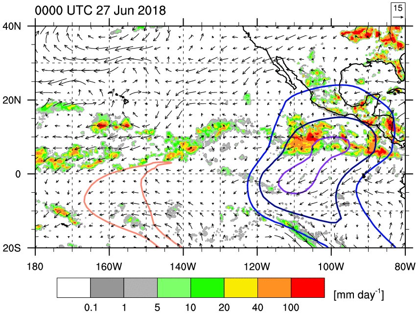
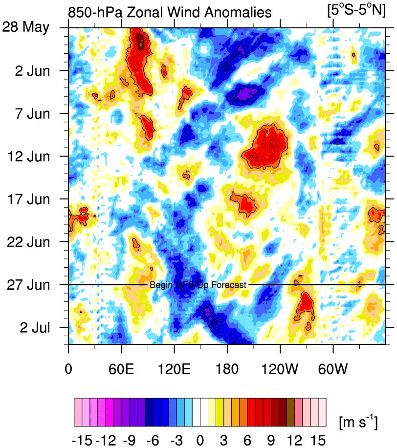
It will be very interesting next 2 weeks ahead to see how the atmosphere works to get a basin to be so favorable to spawn a string of strong Tropical Cyclones.

@webberweather
A CCKW passing thru the NE Pacific will spur a burst of TC activity to kick off July. In addition to preconditioning the atmosphere for TCG, the anomalous westerly wind envelope assoc w/ this CCKW makes it easier for easterly waves in the ITCZ to acquire earth relative westerlies


Image

Image

 https://twitter.com/webberweather/status/1011983975806619648


1 likes   
Visit the Caribbean-Central America Weather Thread where you can find at first post web cams,radars
and observations from Caribbean basin members Click Here

User avatar
cycloneye
Admin
Admin
Posts: 139593
Age: 67
Joined: Thu Oct 10, 2002 10:54 am
Location: San Juan, Puerto Rico

Re: 2018 EPAC Season

#559 Postby cycloneye » Wed Jun 27, 2018 10:52 am

12z ICON has the strongest run yet for future 97E/Fabio.

Image
1 likes   
Visit the Caribbean-Central America Weather Thread where you can find at first post web cams,radars
and observations from Caribbean basin members Click Here

User avatar
cycloneye
Admin
Admin
Posts: 139593
Age: 67
Joined: Thu Oct 10, 2002 10:54 am
Location: San Juan, Puerto Rico

Re: 2018 EPAC Season

#560 Postby cycloneye » Wed Jun 27, 2018 11:37 am

12z GFS loop of future Fabio and Gilma that the model continues to show both very strong while Emila has weakened.

Image
0 likes   
Visit the Caribbean-Central America Weather Thread where you can find at first post web cams,radars
and observations from Caribbean basin members Click Here


Return to “Talkin' Tropics”

Who is online

Users browsing this forum: chaser1, Chris90, Google Adsense [Bot], lilbump3000, MetroMike, storminabox, TheAustinMan and 81 guests