
Either way I guess this thread in-fact won’t be beating the pre-Zeta thread
Area of disturbed weather entering the Caribbean (Is Invest 96L)
Moderator: S2k Moderators
Forum rules

The posts in this forum are NOT official forecasts and should not be used as such. They are just the opinion of the poster and may or may not be backed by sound meteorological data. They are NOT endorsed by any professional institution or STORM2K. For official information, please refer to products from the National Hurricane Center and National Weather Service.
Re: Area of disturbed weather entering the Caribbean
Does the NHC usually designate invests after TWO’s, or around the usual advisory cycles, or just whenever they want?
Either way I guess this thread in-fact won’t be beating the pre-Zeta thread
Either way I guess this thread in-fact won’t be beating the pre-Zeta thread
0 likes
-
Blown Away

- S2K Supporter

- Posts: 10253
- Joined: Wed May 26, 2004 6:17 am
Re: Area of disturbed weather entering the Caribbean
SFLcane wrote:jlauderdal wrote:i survivedSFLcane wrote:This is exactly what the eps has been harping on for a few runs now.3 hour zeta this morning, this one looks far more dangerous..can you imagine we avoid all the systems(we had some weak sauce pass through) this season in sofla until the rare big November cane gets us, that would be so 2020
Far more dangerous yes sir. Again I have had this feeling we are not getting out of this season untouched. Invest coming
Yeah, I’m throwing out my “Climatology” tool this season. Crazy high pressure still in place in the modeling long range, still hard to accept a NW Caribbean November storm moving NNE and then turn W at the latitude of Florida.
1 likes
Hurricane Eye Experience: David 79, Irene 99, Frances 04, Jeanne 04, Wilma 05… Hurricane Brush Experience: Andrew 92, Erin 95, Floyd 99, Matthew 16, Irma 17, Ian 22, Nicole 22…
-
northjaxpro

- S2K Supporter
- Posts: 8900
- Joined: Mon Sep 27, 2010 11:21 am
- Location: Jacksonville, FL
Re: Area of disturbed weather entering the Caribbean
tiger_deF wrote:This is just my 2 cents based on what I have seen so far with the past 3 Greek cat2+!!! in a row. While this is early November and water temperatures are lower as a result than peak season, and even for a good chunk of Delta and Zeta's gulf life the water temperatures were lower than what would be expected, abnormally intense troughs have been moving through the CONUS for the past several weeks, bringing freezing conditions all the way to central Texas and resulting in fairly large temperature swings across a good portion of the United States. These troughs have been providing such intense baroclinic enhancement and positive ventilation that we have seen strong hurricanes with Epsilon, Delta, and Zeta over water temperatures of 27-26 degrees, if not lower. I think that clearly the upper level environment has proved very conductive to development recently, and I imagine that if this system gets it's act together it might benefit from a similar interaction. The 18z GFS run shows future Eta clearly merging with a strong angled trough coming through the south, resulting in it's increasing size and outflow as it moves to the East right above Tampa. I honestly think there is an outside shot at another major, especially if atmospheric conditions verify and the ULL/PVS pattern continues to aid intensification rather than hamper it.
Baroclinic forcing/interaction. Yeah I can definitely see another potential scenario with this potential upcoming cyclone Eta. We saw what just happened with Zeta in how it basically nearly became a major hurricane on its approach to SE Louisiana through this type of interaction with an incoming trough.
1 likes
NEVER, EVER SAY NEVER in the tropics and weather in general, and most importantly, with life itself!!
________________________________________________________________________________________
Fay 2008 Beryl 2012 Debby 2012 Colin 2016 Hermine 2016 Julia 2016 Matthew 2016 Irma 2017 Dorian 2019
________________________________________________________________________________________
Fay 2008 Beryl 2012 Debby 2012 Colin 2016 Hermine 2016 Julia 2016 Matthew 2016 Irma 2017 Dorian 2019
-
Blown Away
- S2K Supporter
- Posts: 10253
- Joined: Wed May 26, 2004 6:17 am
Re: Area of disturbed weather entering the Caribbean
Looking at the 8pm “Red Alert” area, it appears NHC following most of the models taking this area into CA.
1 likes
Hurricane Eye Experience: David 79, Irene 99, Frances 04, Jeanne 04, Wilma 05… Hurricane Brush Experience: Andrew 92, Erin 95, Floyd 99, Matthew 16, Irma 17, Ian 22, Nicole 22…
-
ElectricStorm

- Category 5

- Posts: 5155
- Age: 25
- Joined: Tue Aug 13, 2019 11:23 pm
- Location: Norman, OK
Re: Area of disturbed weather entering the Caribbean
Code red! Should be an invest soon
0 likes
B.S Meteorology, University of Oklahoma '25
Please refer to the NHC, NWS, or SPC for official information.
Please refer to the NHC, NWS, or SPC for official information.
-
AutoPenalti
- Category 5
- Posts: 4091
- Age: 29
- Joined: Mon Aug 17, 2015 4:16 pm
- Location: Ft. Lauderdale, Florida
Re: Area of disturbed weather entering the Caribbean
Blown Away wrote:Looking at the 8pm “Red Alert” area, it appears NHC following most of the models taking this area into CA.
Bear in mind, the red shaded area explains where NHC believes development chances will occur, it is not a track.
6 likes
The posts in this forum are NOT official forecasts and should not be used as such. They are just the opinion of the poster and may or may not be backed by sound meteorological data. They are NOT endorsed by any professional institution or STORM2K. For official information, please refer to products from the NHC and NWS.
Model Runs Cheat Sheet:
GFS (5:30 AM/PM, 11:30 AM/PM)
HWRF, GFDL, UKMET, NAVGEM (6:30-8:00 AM/PM, 12:30-2:00 AM/PM)
ECMWF (1:45 AM/PM)
TCVN is a weighted averaged
Re: Area of disturbed weather entering the Caribbean
While I agree it will impact CA, remember that it will very likely not be a fast or even medium pace shot into CA. I predict this will meander and be very slowww, which is sad for the folks there due to their Geography and history with storms there.
I doubt this thing will stay there and fissle or crossover though. I’d imagine something will bring this back NE into the Caribeean if it wasn’t at that point and swing either into Cuba or *gulp* yes South Florida.
I see no reason right now to support this affecting only CA.
2020 has had it’s own climatology this year, and everything this fall has been getting pulled in some direction North and plenty of models are already showing that.
4 likes
-
gatorcane

- S2K Supporter
- Posts: 23708
- Age: 48
- Joined: Sun Mar 13, 2005 3:54 pm
- Location: Boca Raton, FL
Re: Area of disturbed weather entering the Caribbean
Hmmm on that 18Z GFS run. The 500mb pattern actually is not much different than the 12Z, if anything there is more ridging over the Gulf. But since it is not as deep of a system in the 18Z, looks like it doesn’t get shoved into CA (Central America) with the 500MB flow. In other words, a stronger system may mean more west and into CA in this case. Trend GIF between 12Z and 18Z below.
0 likes

Re: Area of disturbed weather entering the Caribbean
@Gatorcane  this was posted earlier by SFLcane. Looks like the opposite.
0 likes
The following post is NOT an official forecast and should not be used as such. It is just the opinion of the poster and may or may not be backed by sound meteorological data. It is NOT endorsed by any professional institution including storm2k.org For Official Information please refer to the NHC and NWS products.
-
gatorcane
- S2K Supporter
- Posts: 23708
- Age: 48
- Joined: Sun Mar 13, 2005 3:54 pm
- Location: Boca Raton, FL
Re: Area of disturbed weather entering the Caribbean
blp wrote:@Gatorcane
I am talking about when the cyclone is near the CA coast with the high over the Gulf. Obviously if it develops faster it would potentially end up a bit more north in the Western Caribbean as it feels the trough over the SW Atlantic. That is what I think Eric is talking about.
0 likes
-
AutoPenalti
- Category 5
- Posts: 4091
- Age: 29
- Joined: Mon Aug 17, 2015 4:16 pm
- Location: Ft. Lauderdale, Florida
Re: Area of disturbed weather entering the Caribbean
blp wrote:@Gatorcane
Run from gatorcane isn’t the full run.
0 likes
The posts in this forum are NOT official forecasts and should not be used as such. They are just the opinion of the poster and may or may not be backed by sound meteorological data. They are NOT endorsed by any professional institution or STORM2K. For official information, please refer to products from the NHC and NWS.
Model Runs Cheat Sheet:
GFS (5:30 AM/PM, 11:30 AM/PM)
HWRF, GFDL, UKMET, NAVGEM (6:30-8:00 AM/PM, 12:30-2:00 AM/PM)
ECMWF (1:45 AM/PM)
TCVN is a weighted averaged
Area of disturbed weather entering the Caribbean
Not often you see a wave cruise in to the Caribbean from the Atlantic and form at this time of year...But I guess that’s why the season doesn’t end until December...
4 likes


Re: Area of disturbed weather entering the Caribbean
Sanibel wrote:Not often you see a wave cruise in to the Caribbean from the Atlantic and form at this time of year...But I guess that’s why the season doesn’t end until December...
I swear, watch this season end in January like 2005...
1 likes

Re: Area of disturbed weather entering the Caribbean
18Z GFS is going with the spin-up under the anticyclone on Saturday.
Lining up with CMC now.
This could be a quick ramp up.
Guess that's why NHC went code red.

Lining up with CMC now.
This could be a quick ramp up.
Guess that's why NHC went code red.
2 likes
-
Blown Away
- S2K Supporter
- Posts: 10253
- Joined: Wed May 26, 2004 6:17 am
Re: Area of disturbed weather entering the Caribbean
AutoPenalti wrote:Blown Away wrote:Looking at the 8pm “Red Alert” area, it appears NHC following most of the models taking this area into CA.
Bear in mind, the red shaded area explains where NHC believes development chances will occur, it is not a track.
I agree, but many times you can get an idea where the NHC thinks the area will move based on the orientation and shape.
0 likes
Hurricane Eye Experience: David 79, Irene 99, Frances 04, Jeanne 04, Wilma 05… Hurricane Brush Experience: Andrew 92, Erin 95, Floyd 99, Matthew 16, Irma 17, Ian 22, Nicole 22…
-
SFLcane

- S2K Supporter
- Posts: 10281
- Age: 48
- Joined: Sat Jun 05, 2010 1:44 pm
- Location: Lake Worth Florida
Re: Area of disturbed weather entering the Caribbean
Blown Away wrote:AutoPenalti wrote:Blown Away wrote:Looking at the 8pm “Red Alert” area, it appears NHC following most of the models taking this area into CA.
Bear in mind, the red shaded area explains where NHC believes development chances will occur, it is not a track.
I agree, but many times you can get an idea where the NHC thinks the area will move based on the orientation and shape.
Meh that development cone was a copy and paste from Jack.
0 likes
Re: Area of disturbed weather entering the Caribbean
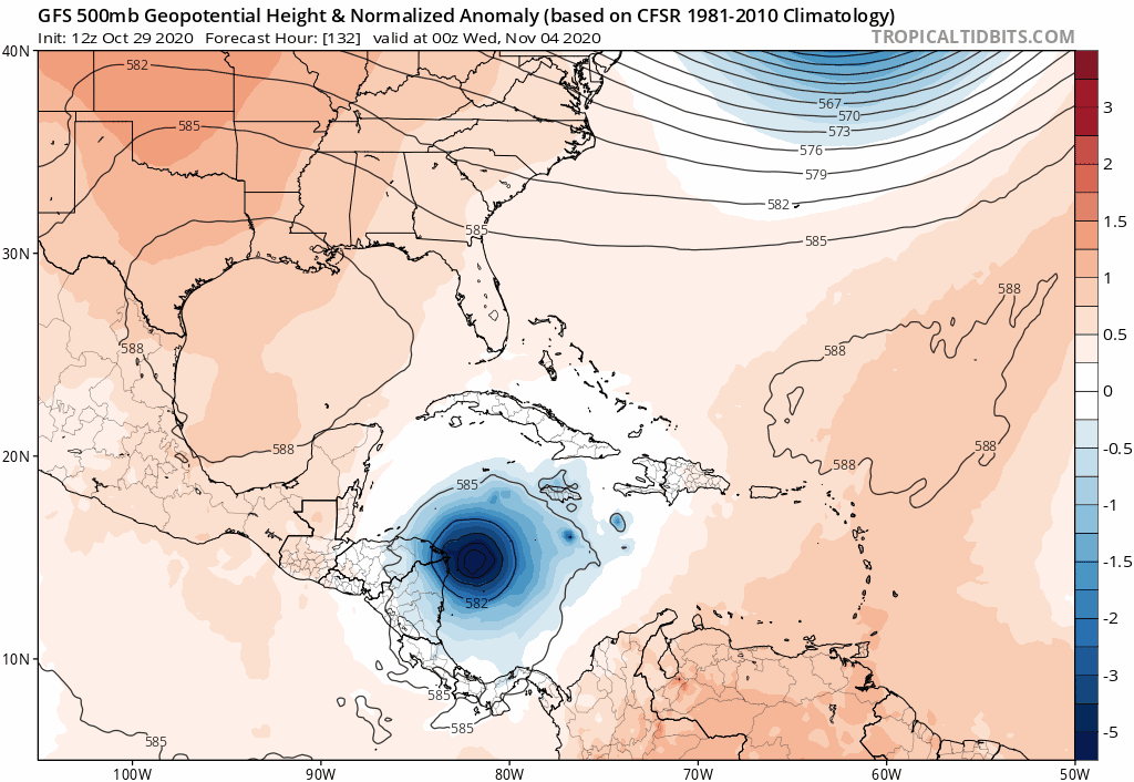
LarryWx wrote:Happy Hour GEFS: this run and others as well as EPS runs have been suggesting that there will be unseasonably intense upper ridging semi-anchored centered over the NE US with a strong surface high of perhaps as strong as 1040 mb also semi-anchored for a few days around Nov 8-10. At the same time, many members have a strong TC moving N or NNE over or near FL that runs into the huge blocking ridge and either stalls it or even turns it W or WSW back into the SE US if offshore. What a crazy setup if this occurs, but it is a strong La Nina with a +AMO and a very warm W Pacific, which combined tends to enhance E US ridging. And of course, it is 2020!
https://i.imgur.com/EBGNLoP.png
Also Larry, haven't scrolled back thru pages so I'm not sure if it's been mentioned, but todays EPS seemed to have an uptick in activity (some of it strong!) in the Cuba/FL/Bahamas area
0 likes
-
cycloneye

- Admin

- Posts: 149715
- Age: 69
- Joined: Thu Oct 10, 2002 10:54 am
- Location: San Juan, Puerto Rico
Re: Area of disturbed weather entering the Caribbean (Is Invest 96L)
1 likes
Visit the Caribbean-Central America Weather Thread where you can find at first post web cams,radars
and observations from Caribbean basin members Click Here
and observations from Caribbean basin members Click Here
Who is online
Users browsing this forum: Ed_2001 and 212 guests