
ENSO Updates (2007 thru 2023)
Moderator: S2k Moderators
Forum rules

The posts in this forum are NOT official forecasts and should not be used as such. They are just the opinion of the poster and may or may not be backed by sound meteorological data. They are NOT endorsed by any professional institution or STORM2K. For official information, please refer to products from the National Hurricane Center and National Weather Service.

Re: ENSO Updates
Jeff Masters is saying that we could see La Niña again.
http://www.wunderground.com/blog/JeffMa ... rynum=1182
Right now, we are in a Neutral phase of El Niño Southern Oscillation (ENSO). Neutral is a mix bag for hurricane season, Neutral phase can be either be below average, average, or above average. Some of the most active hurricane seasons have occurred in Neutral phase of ENSO, like 1886, 1887, 1933, and 2005. La Niña is also very active, but the season tends to start later and there tends to be more hurricanes and major hurricanes forming.
0 likes
-
cycloneye

- Admin

- Posts: 149405
- Age: 69
- Joined: Thu Oct 10, 2002 10:54 am
- Location: San Juan, Puerto Rico
Re: ENSO Updates
Here is an animation of how La Nina of 1998-1999 became established.
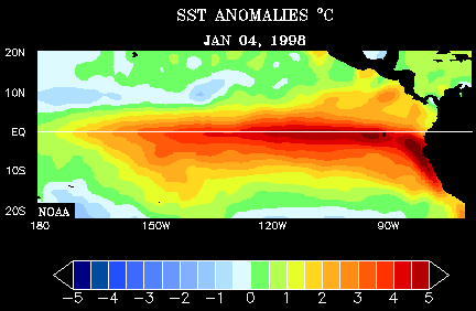
Graphic of latest anomalies in Pacific.El Nino 1-2 region is warmer that the rest.As long el Nino 3-4 continues with cool waters,no El Nino will be in the horizon.


Graphic of latest anomalies in Pacific.El Nino 1-2 region is warmer that the rest.As long el Nino 3-4 continues with cool waters,no El Nino will be in the horizon.
0 likes
-
cycloneye
- Admin
- Posts: 149405
- Age: 69
- Joined: Thu Oct 10, 2002 10:54 am
- Location: San Juan, Puerto Rico
Re: ENSO Updates
The latest BoM (Aussies) update of ENSO:
During December cold SST anomalies developed across the central and eastern equatorial Pacific. By the end of December cooler than normal water had spread along the equator from approximately 180³E to 110³W. The tropical Pacific has warmed slightly through January, however, cool anomalies are still present across the central and eastern equatorial Pacific. The monthly NINO indices for December were –0.4°C, –0.6°C and –0.7°C for NINO3, NINO4 and NINO3.4 respectively.
In terms of weekly data, NINO indices this week were –0.1°C, –0.6°C and –0.7°C for NINO3, NINO4 and NINO3.4 respectively. Over the past two weeks warming has occurred in each NINO region. NINO3 warmed by approximately 0.4°C, NINO3.4 by approximately 0.3°C and NINO4 by approximately 0.1°C. When compared with three weeks ago, the 7-day SST anomaly map shows a weakening of negative anomalies across the central and eastern equatorial Pacific. Weak warm anomalies are also now evident on a weekly scale along the equator, between approximately 110°W and the South American coast. An animation of recent SST changes is available.
A large volume of sub-surface water extending from the central to eastern equatorial Pacific has been anomalously cool since September. During December, anomalously warm sub-surface water developed in the western equatorial Pacific, propagating eastwards into the central equatorial Pacific during January. A recent map for the 5 days ending 26 January shows a large area of sub-surface warm anomalies above +1.0°C extending across the central and western tropical Pacific. East of 150°W sub-surface water is generally below average, with a large volume of water below –1.0°C. A small area of sub-surface anomaly below –3.0°C is evident between 140°W and 110°W on a weekly scale. An animation of recent sub-surface changes is available.

An archive of past SST and sub-surface temperature charts is available.
Trade winds have weakened across the Pacific and are now close to normal across most of the central and eastern equatorial Pacific. The latest weekly wind anomalies are shown in the TAO/TRITON map (small image above) for the five days ending 26 January.
The Southern Oscillation Index (SOI) has been strongly positive since late August. Recently the SOI has fallen slightly with +9 the latest 30 day value for the 26 January. The monthly value for December was +13 (SOI graph, SOI table).

Cloudiness near the date-line over the central to western Pacific is another important indicator of warm/cool ENSO conditions, as it normally increases/decreases (negative OLR/positive OLR anomalies) during these episodes. Cloudiness near the equatorial date-line was slightly below average through the austral winter and spring. Cloudiness near the date-line decreased further in December, coinciding with cooling of the sea surface in the region. Recently cloudiness has increased slightly, although is still below average.
The majority of international dynamic computer models surveyed by the Bureau of Meteorology predict a continuation of neutral conditions for the tropical Pacific. Four of the six models are predicting neutral conditions for coming months, while two models predict La Niña conditions. Recent warming and the eastward propagation of warm sub-surface water from the western equatorial Pacific suggests that the cooler conditions in the Pacific may not persist much beyond summer 2009. The most likely scenario is for the central and eastern Pacific to warm further over the coming months and to remain neutral. Recent forecasts from the POAMA model, run daily at the Bureau of Meteorology, predict ENSO-neutral conditions to persist through the coming months.
http://www.bom.gov.au/climate/enso/
During December cold SST anomalies developed across the central and eastern equatorial Pacific. By the end of December cooler than normal water had spread along the equator from approximately 180³E to 110³W. The tropical Pacific has warmed slightly through January, however, cool anomalies are still present across the central and eastern equatorial Pacific. The monthly NINO indices for December were –0.4°C, –0.6°C and –0.7°C for NINO3, NINO4 and NINO3.4 respectively.
In terms of weekly data, NINO indices this week were –0.1°C, –0.6°C and –0.7°C for NINO3, NINO4 and NINO3.4 respectively. Over the past two weeks warming has occurred in each NINO region. NINO3 warmed by approximately 0.4°C, NINO3.4 by approximately 0.3°C and NINO4 by approximately 0.1°C. When compared with three weeks ago, the 7-day SST anomaly map shows a weakening of negative anomalies across the central and eastern equatorial Pacific. Weak warm anomalies are also now evident on a weekly scale along the equator, between approximately 110°W and the South American coast. An animation of recent SST changes is available.
A large volume of sub-surface water extending from the central to eastern equatorial Pacific has been anomalously cool since September. During December, anomalously warm sub-surface water developed in the western equatorial Pacific, propagating eastwards into the central equatorial Pacific during January. A recent map for the 5 days ending 26 January shows a large area of sub-surface warm anomalies above +1.0°C extending across the central and western tropical Pacific. East of 150°W sub-surface water is generally below average, with a large volume of water below –1.0°C. A small area of sub-surface anomaly below –3.0°C is evident between 140°W and 110°W on a weekly scale. An animation of recent sub-surface changes is available.
An archive of past SST and sub-surface temperature charts is available.
Trade winds have weakened across the Pacific and are now close to normal across most of the central and eastern equatorial Pacific. The latest weekly wind anomalies are shown in the TAO/TRITON map (small image above) for the five days ending 26 January.
The Southern Oscillation Index (SOI) has been strongly positive since late August. Recently the SOI has fallen slightly with +9 the latest 30 day value for the 26 January. The monthly value for December was +13 (SOI graph, SOI table).
Cloudiness near the date-line over the central to western Pacific is another important indicator of warm/cool ENSO conditions, as it normally increases/decreases (negative OLR/positive OLR anomalies) during these episodes. Cloudiness near the equatorial date-line was slightly below average through the austral winter and spring. Cloudiness near the date-line decreased further in December, coinciding with cooling of the sea surface in the region. Recently cloudiness has increased slightly, although is still below average.
The majority of international dynamic computer models surveyed by the Bureau of Meteorology predict a continuation of neutral conditions for the tropical Pacific. Four of the six models are predicting neutral conditions for coming months, while two models predict La Niña conditions. Recent warming and the eastward propagation of warm sub-surface water from the western equatorial Pacific suggests that the cooler conditions in the Pacific may not persist much beyond summer 2009. The most likely scenario is for the central and eastern Pacific to warm further over the coming months and to remain neutral. Recent forecasts from the POAMA model, run daily at the Bureau of Meteorology, predict ENSO-neutral conditions to persist through the coming months.
http://www.bom.gov.au/climate/enso/
0 likes
-
hurricanetrack

- HurricaneTrack.com

- Posts: 1781
- Joined: Tue Dec 02, 2003 10:46 pm
- Location: Wilmington, NC
- Contact:
That sub-surface warm area is certainly expanding east. Have you also noticed on the weekly Reynolds SST anomalies map that the area west of Africa is now quite cool compared to normal? Perhaps there are some stronger winds pushing off Africa now creating upwelling conditions.
http://www.nhc.noaa.gov/tafb/atl_anom.gif
http://www.nhc.noaa.gov/tafb/atl_anom.gif
0 likes
-
cycloneye
- Admin
- Posts: 149405
- Age: 69
- Joined: Thu Oct 10, 2002 10:54 am
- Location: San Juan, Puerto Rico
Re:
hurricanetrack wrote:That sub-surface warm area is certainly expanding east. Have you also noticed on the weekly Reynolds SST anomalies map that the area west of Africa is now quite cool compared to normal? Perhaps there are some stronger winds pushing off Africa now creating upwelling conditions.
http://www.nhc.noaa.gov/tafb/atl_anom.gif
Yes,I mentioned that in the Atlantic sst,s and Anomallies thread.Lets see how that changes in the next few weeks.
viewtopic.php?f=31&t=104455&p=1861342#p1861342
0 likes
-
cycloneye
- Admin
- Posts: 149405
- Age: 69
- Joined: Thu Oct 10, 2002 10:54 am
- Location: San Juan, Puerto Rico
Re: ENSO Updates
Below is the latest update of ENSO by Climate Prediction Center.
La Nina conditions to continue thru Spring
Synopsis: La Niña is expected to continue into Northern Hemisphere Spring 2009.
La Niña continued during January 2009, as evidenced by below-average equatorial sea surface temperatures (SST) across the central and east-central Pacific Ocean (Fig. 1). The Niño-4 and Niño-3.4 SST indices remained cooler than -0.5°C throughout January, although positive index values developed in the easternmost Niño-1+2 region late in the month (Fig. 2). Negative subsurface oceanic heat content anomalies (average temperatures in the upper 300m of the ocean, Fig. 3) also persisted east of the International Date Line, but weakened as positive subsurface temperature anomalies from the western Pacific expanded eastward into the central Pacific (Fig. 4). Convection remained suppressed near the Date Line, and enhanced across Indonesia. Low-level easterly winds and upper-level westerly winds also continued across the equatorial Pacific Ocean. Collectively, these oceanic and atmospheric anomalies reflect La Niña.
A majority of the model forecasts for the Niño-3.4 region indicate a gradual weakening of La Niña through February-April 2009, with an eventual transition to ENSO-neutral conditions (Fig. 5). Therefore, based on current observations, recent trends, and model forecasts, La Niña is expected to continue into the Northern Hemisphere Spring 2009.
Expected La Niña impacts during February-April 2009 include above-average precipitation over Indonesia, and below-average precipitation over the central equatorial Pacific. For the contiguous United States, potential impacts include above-average precipitation in the Ohio and Tennessee Valleys and below-average precipitation in the southwestern and southeastern states. Other potential impacts include below-average temperatures in the Pacific Northwest and above-average temperatures across much of the southern United States.
http://www.cpc.noaa.gov/products/analys ... odisc.html
0 likes
-
Ed Mahmoud
Re: ENSO Updates
Bastardi believes a weak El Niño will develop this Summer.
He talks about it relative to when it starts to weaken next Winter, and implications for a rough Winter 2009-2010.
A weak El N surpressing MDR hurricanes a tad and giving the US and especially Haiti and Cuba a quiet or relatively quiet year, he didn't mention, but as long as we get some serious rain in Texas the next few months from non-tropical sources to reduce the drought, a quiet season won't hurt my feelings at all.
0 likes
-
Tampa Bay Hurricane

- Category 5
- Posts: 5597
- Age: 38
- Joined: Fri Jul 22, 2005 7:54 pm
- Location: St. Petersburg, FL


Re: ENSO Updates
cycloneye wrote:Below is the latest update of ENSO by Climate Prediction Center.
La Niña is expected to continue into the Northern Hemisphere Spring 2009.
Expected La Niña impacts during February-April 2009 include.... below-average precipitation in the southwestern and southeastern states.
We're seeing some evidence of this already. CPC also had an article on predicted drought and showed our region with increasing drought through spring. IIRC, La Niña brings drought conditions to this area.
0 likes
-
wxman57

- Moderator-Pro Met

- Posts: 23173
- Age: 68
- Joined: Sat Jun 21, 2003 8:06 pm
- Location: Houston, TX (southwest)
Re: ENSO Updates
Bastardi appears to be monitoring NCEP's web site and its Nino 3.4 projections.
Current projections:

Though it's possible that a weak El Nino may emerge by late summer, the NCEP models were wrong in predicting it last year, as evident by the map below. These long-range El Nino/La Nina forecasts are notoriously bad. Can't rule out an El Nino, of course, but odds are that neutral conditions will prevail.
Forecast from last May:
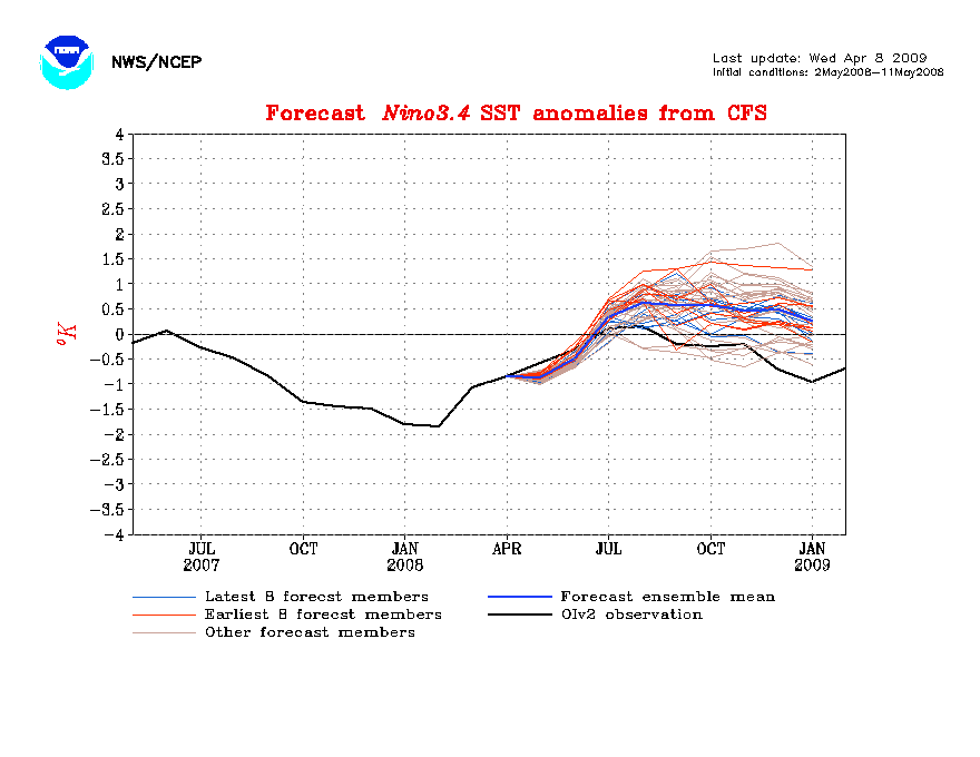
Current projections:
Though it's possible that a weak El Nino may emerge by late summer, the NCEP models were wrong in predicting it last year, as evident by the map below. These long-range El Nino/La Nina forecasts are notoriously bad. Can't rule out an El Nino, of course, but odds are that neutral conditions will prevail.
Forecast from last May:
0 likes
-
cycloneye
- Admin
- Posts: 149405
- Age: 69
- Joined: Thu Oct 10, 2002 10:54 am
- Location: San Juan, Puerto Rico
Re: ENSO Updates
You can see below how La nina has dominated in the past few months and continues to do so now.
Loop of La Nina
Loop of La Nina
0 likes
-
Ed Mahmoud
Re: ENSO Updates
wxman57 wrote:Bastardi appears to be monitoring NCEP's web site and its Nino 3.4 projections.
Current projections:
Though it's possible that a weak El Nino may emerge by late summer, the NCEP models were wrong in predicting it last year, as evident by the map below. These long-range El Nino/La Nina forecasts are notoriously bad. Can't rule out an El Nino, of course, but odds are that neutral conditions will prevail.
Forecast from last May:
JB says his late Winter analogs to 1969 seem to be working for him, and he thinks it may continue into the Summer.
No suggestion that a Category 5 Hurricane Claudette will hit Mississippi in mid August. No suggestion whatsoever.
0 likes
-
cycloneye
- Admin
- Posts: 149405
- Age: 69
- Joined: Thu Oct 10, 2002 10:54 am
- Location: San Juan, Puerto Rico
Re: ENSO Updates
For those who dont remember or dont know how active was the 1969 season,below are all the systems that were named that year.
http://weather.unisys.com/hurricane/atl ... index.html
http://weather.unisys.com/hurricane/atl ... index.html
0 likes
-
wxman57
- Moderator-Pro Met
- Posts: 23173
- Age: 68
- Joined: Sat Jun 21, 2003 8:06 pm
- Location: Houston, TX (southwest)
Re: ENSO Updates
NCEP ensembles are now going for a full-blown El Nino by the start of the season. See the map above now valid Feb. 17th (today). If that would actually verify, then it could mean fewer-than-average number of storms in 2009.
0 likes

Of course thats the issue, if it verifies, it certainly didn't last year. Despite that I suspect we will go weakly El Nino by the summer, probably enough to shut the season down but I think the meat of the season will still be very much on the busy side, I wouldn't expect anything like the 1992/97 type shut down we saw.
0 likes
-
cycloneye
- Admin
- Posts: 149405
- Age: 69
- Joined: Thu Oct 10, 2002 10:54 am
- Location: San Juan, Puerto Rico
Re: ENSO Updates
POAMA model latest forecast for September a weak el nino:


http://www.bom.gov.au/climate/coupled_model/poama.shtml
http://www.bom.gov.au/climate/coupled_model/poama.shtml
0 likes
-
cycloneye
- Admin
- Posts: 149405
- Age: 69
- Joined: Thu Oct 10, 2002 10:54 am
- Location: San Juan, Puerto Rico
Re: ENSO Updates
The latest BoM (Aussies) Update of ENSO:
Details
During December cold SST anomalies developed across the central and eastern equatorial Pacific. These cool anomalies persisted through January and early February. The monthly NINO indices for January were –0.3°C, –0.7°C and –0.8°C for NINO3, NINO4 and NINO3.4 respectively, and were similar in magnitude to December values.
In terms of weekly data, NINO indices this week were –0.4°C, –0.7°C and –0.6°C for NINO3, NINO4 and NINO3.4 respectively. Over the past two weeks NINO3 has cooled by 0.3°C, while NINO4 and NINO3.4 have remained similar in magnitude. When compared with three weeks ago the 7-day SST anomaly map is similar across the central equatorial Pacific, with weak cool anomalies extending along the equater. However, the area of cool anomalies below –1°C has decreased. The weak warm anomalies that were evident on a weekly scale near the South American coast three weeks ago have weakened, with areas of weak cold anomalies now evident. An animation of recent SST changes is available.
A large volume of sub-surface water extending from the central to eastern equatorial Pacific has been anomalously cool since September. During December, anomalously warm sub-surface water developed in the western equatorial Pacific, propagating eastwards into the central equatorial Pacific during January. Both the western and eastern sub-surface ocean in the tropical Pacific has warmed over the past three weeks, whilst temperatures in the central Pacific have cooled slightly over the same period. A recent map for the 5 days ending 16 February shows a large area of sub-surface warm anomalies above +1.0°C extending across the western equatorial Pacific. East of 170°W sub-surface water temperature is generally below average, with a large volume of water below –1.0°C. An animation of recent sub-surface changes is available.
An archive of past SST and sub-surface temperature charts is available.
Trade winds remain close to normal across most of the central and eastern equatorial Pacific, while stronger than usual trade winds are still observed across the western equatorial Pacific. The latest weekly wind anomalies are shown in the TAO/TRITON map (small image above) for the five days ending 26 February.
The Southern Oscillation Index (SOI) has been strongly positive since late August. The latest 30 day value for the 16 February is 14. The monthly value for January was +9 (SOI graph, SOI table).
Cloudiness near the date-line over the central to western Pacific is another important indicator of warm/cool ENSO conditions, as it normally increases/decreases (negative OLR/positive OLR anomalies) during these episodes. Cloudiness near the date-line decreased in December, coinciding with cooling of the sea surface in the region. Cloudiness increased a little during January but remained below average and has recently decreased again further early February.
The majority of international dynamic computer models surveyed by the Bureau of Meteorology predict a continuation of neutral conditions for the tropical Pacific. Four of the five models surveyed this month are predicting neutral conditions for coming months, while one model predicts La Niña conditions. Recent warming of the sub-surface in the western Pacific and weakening of cold sub-surface anomalies in the eastern Pacific suggest that the cooler conditions in the Pacific may not persist long into autumn. The most likely scenario is for the central and eastern Pacific to warm further over the coming months and to remain neutral. Recent forecasts from the POAMA model, run daily at the Bureau of Meteorology, predict ENSO-neutral conditions to persist through the coming months.
http://www.bom.gov.au/climate/enso/
30 day SOI Index:
Cycloneye take=It may be neutral during the meat of the season (August,September) ,but El Nino may appear by the last leg (October,November) shutting the rest of the season down.However,its too early to know for sure that far what ENSO will be by that time.
0 likes
-
cycloneye
- Admin
- Posts: 149405
- Age: 69
- Joined: Thu Oct 10, 2002 10:54 am
- Location: San Juan, Puerto Rico
Re: ENSO Updates
El Nino 3 projections are a little less bullish about El Nino than el nino 3-4 ones.Based on it,a weak el nino may appear by late September rather than in July,when El Nino 3-4 projections are.Also is interesting that the SOI is still creeping up,now positive 15. (See graphic at above post)
Repost from the 2009 Atlantic Hurricane Season Guessing Game thread:
57,2004 was an El Nino year,(Although not a strong one) http://www.cpc.ncep.noaa.gov/products/a ... c_sep2004/ and look what happened with those many Florida landfalls caused by the position of the subtropical ridge that favored the tracks towards the Florida Penninsula.I think we have to wait until late April or early May to be sure about having El Nino or not in 2009.It only takes one system to do all the damage in an area,even if the strongest El Nino ever appears this year.
0 likes
Who is online
Users browsing this forum: Iceresistance and 305 guests