2011 Steering Pattern/Early indicators
Moderator: S2k Moderators
Forum rules

The posts in this forum are NOT official forecasts and should not be used as such. They are just the opinion of the poster and may or may not be backed by sound meteorological data. They are NOT endorsed by any professional institution or STORM2K. For official information, please refer to products from the National Hurricane Center and National Weather Service.
-
wxman57

- Moderator-Pro Met

- Posts: 23175
- Age: 68
- Joined: Sat Jun 21, 2003 8:06 pm
- Location: Houston, TX (southwest)
Re: 2011 Steering Pattern/Early indicators
Right. Analog years aren't "the law" as far as paths for 2011. They just suggest patterns that might be observed as far as development and movement. There are so many variables involved in determining where a hurricane eventually makes landfall. A small pocket of shear that develops in the mid Atlantic east of the Caribbean may delay development of a disturbance for a day. That delay in development might mean the difference in a Florida or East U.S. Coast hit or a Bermuda hit. Timing is everything. No one is safe from a possible impact because of any pattern indicated by analog years.
0 likes
-
Blown Away

- S2K Supporter

- Posts: 10253
- Joined: Wed May 26, 2004 6:17 am
Re: 2011 Steering Pattern/Early indicators
Great info Wxman57!!! Is the prediction of the east coast tracks due to a more positive NAO prediction (Stronger BH) vs the negative NAO we saw last season??
Edit: Change 1995 in your text to 1955.
Edit: Change 1995 in your text to 1955.
0 likes
Hurricane Eye Experience: David 79, Irene 99, Frances 04, Jeanne 04, Wilma 05… Hurricane Brush Experience: Andrew 92, Erin 95, Floyd 99, Matthew 16, Irma 17, Ian 22, Nicole 22…
Re: 2011 Steering Pattern/Early indicators
Helpful layout there WX57 but like you mentioned slight variations are destined to occur and from that all along the US coastline need to have an eye on the tropics this year!I am not fond of cold winters w/lows in the GOM and a possibility of a neutral season.
0 likes
-
wxman57
- Moderator-Pro Met
- Posts: 23175
- Age: 68
- Joined: Sat Jun 21, 2003 8:06 pm
- Location: Houston, TX (southwest)
Re: 2011 Steering Pattern/Early indicators
Javlin wrote:Helpful layout there WX57 but like you mentioned slight variations are destined to occur and from that all along the US coastline need to have an eye on the tropics this year!I am not fond of cold winters w/lows in the GOM and a possibility of a neutral season.
If you're asking if I think you're protected there on the MS coast this year, then I'd say no. Analog seasons would suggest a threat farther west (MX/TX/LA), but it's all about the timing of any storm moving into the Gulf. Prepare for this season as you would for any season. Doesn't matter what analogs indicate.
0 likes
-
Ivanhater

- Storm2k Moderator

- Posts: 11221
- Age: 39
- Joined: Fri Jul 01, 2005 8:25 am
- Location: Pensacola
Re: 2011 Steering Pattern/Early indicators
Blown Away wrote:Great info Wxman57!!! Is the prediction of the east coast tracks due to a more positive NAO prediction (Stronger BH) vs the negative NAO we saw last season??
Edit: Change 1995 in your text to 1955.
Here is a good graphic showing the state of the NAO and what favors an east coast or Gulf coast threat...
[img]

Uploaded with ImageShack.us[/img]
0 likes
Michael
-
Blown Away
- S2K Supporter
- Posts: 10253
- Joined: Wed May 26, 2004 6:17 am
Re: 2011 Steering Pattern/Early indicators
Great illustration, but generally doesn't the +/- NAO pattern changes many times over the year? So when Klotzbach says there will be a +NAO for the 2011 hurricane season, is he generally saying the positive pattern will dominate overall?? Am I understanding correctly? 
0 likes
Hurricane Eye Experience: David 79, Irene 99, Frances 04, Jeanne 04, Wilma 05… Hurricane Brush Experience: Andrew 92, Erin 95, Floyd 99, Matthew 16, Irma 17, Ian 22, Nicole 22…
-
PTrackerLA

- Category 5

- Posts: 5281
- Age: 42
- Joined: Thu Oct 10, 2002 8:40 pm
- Location: Lafayette, LA
Re: 2011 Steering Pattern/Early indicators
Great stuff wxman, thanks for sharing! Have a feeling the relative quietness of the past 3 years (US landfall wise) will be coming to an end this summer.
0 likes
-
wxman57
- Moderator-Pro Met
- Posts: 23175
- Age: 68
- Joined: Sat Jun 21, 2003 8:06 pm
- Location: Houston, TX (southwest)
Re: 2011 Steering Pattern/Early indicators
Blown Away wrote:Great illustration, but generally doesn't the +/- NAO pattern changes many times over the year? So when Klotzbach says there will be a +NAO for the 2011 hurricane season, is he generally saying the positive pattern will dominate overall?? Am I understanding correctly?
Yes, that's correct. But a +NAO for the season doesn't mean it's always positive. The NAO is constantly changing through the season, that's why timing of any tropical development is so important - and that's why no one is guaranteed to be safe.
0 likes
-
OuterBanker
- S2K Supporter
- Posts: 1761
- Joined: Wed Feb 26, 2003 10:53 am
- Location: Nags Head, NC
- Contact:
Although it's with a nervous laugh, I still have to laugh a little.
It's as if you deliberately picked the worst comparable years you could find for your particular area.
1955 had three landfalling hurricanes in North Carolina. 1996 had two landfalling hurricanes and 1999 had two landfalling hurricanes with Floyd being the worst catastrophe this state ever had.
If you open up all the tracks for all the hurricanes of all the comparable years you would probably say to yourself "I'm outta here".
It's like using 2004 and 2005 as comparables living in Florida.
But my biggest fear is that the insurance companies will get a hold of this and use it as either an excuse to raise our rates or avoid writing altogether.
As we all know hype and perception can cause far more damage that any storm ever has.
0 likes
-
Blown Away
- S2K Supporter
- Posts: 10253
- Joined: Wed May 26, 2004 6:17 am
Re: 2011 Steering Pattern/Early indicators
I agree those are legendary Carolinas analog years! Hope they are wrong on their predictions...
0 likes
Hurricane Eye Experience: David 79, Irene 99, Frances 04, Jeanne 04, Wilma 05… Hurricane Brush Experience: Andrew 92, Erin 95, Floyd 99, Matthew 16, Irma 17, Ian 22, Nicole 22…
Re: 2011 Steering Pattern/Early indicators
wxman57 wrote:Javlin wrote:Helpful layout there WX57 but like you mentioned slight variations are destined to occur and from that all along the US coastline need to have an eye on the tropics this year!I am not fond of cold winters w/lows in the GOM and a possibility of a neutral season.
If you're asking if I think you're protected there on the MS coast this year, then I'd say no. Analog seasons would suggest a threat farther west (MX/TX/LA), but it's all about the timing of any storm moving into the Gulf. Prepare for this season as you would for any season. Doesn't matter what analogs indicate.
Naw,wasn't impling that at all just some things I have noticed on patterns and I am thinking 05 pattern for the GOM so heads up!We will have to see what comes about Sir.Cheers
0 likes
-
Rgv20

- S2K Supporter
- Posts: 2466
- Age: 39
- Joined: Wed Jan 05, 2011 5:42 pm
- Location: Edinburg/McAllen Tx
This is the Forecast from Crownweather Services
http://www.crownweather.com/?page_id=4557
http://www.crownweather.com/?page_id=4557
Our 2011 Hurricane Season Forecast
Rob Lightbown on April 9, 2011, 9:13 am
This is an updated and now official seasonal forecast on the upcoming 2011 Hurricane Season from us here at Crown Weather Services.
ENSO Conditions: The current La Nina conditions are currently diminishing and I fully expect we will be in neutral conditions during the 2011 Hurricane Season. This thinking is fully supporting by both the CFS and European climate models. There has been some talk about El Nino conditions appearing during the Hurricane Season; I do not think that this will happen and we should stay in neutral conditions right through the summer and fall months.
Analog Years: I have changed some of the analog years that I am using for this hurricane season based on analysis over the last four to six weeks. The analog years that are a close match to what this hurricane season may be like are 1899, 1950, 1955, 1996, 1999 and 2008.
1899:
1950:
1955:
1996:
1999:
2008:
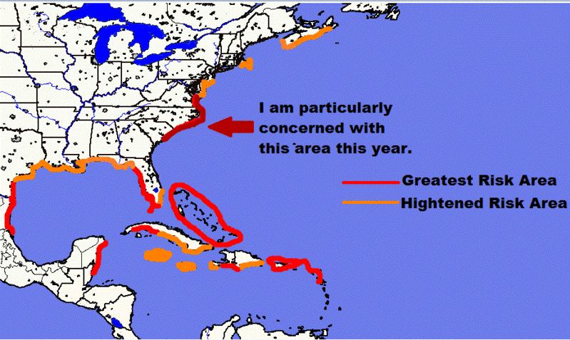
Risk Areas: I have drawn out a risk area map based on the analog years and expected weather patterns this summer and fall which includes a stronger Bermuda high pressure system in the Atlantic. I am very concerned with the coasts of North Carolina and northeastern South Carolina. In addition, I have outlined the Leeward Islands, Virgin Islands, Puerto Rico, the Bahamas, the west coast of Florida, western Cuba, the south coast of Haiti, Belize and the east coast of the Yucatan Peninsula, northern Mexico and south Texas in the greatest risk areas for being impacted by a hurricane this year.
Risk Map For The 2011 Hurricane Season:
I still anticipate a total of 15 named storms, 9 of those storms becoming hurricanes and 4 of those hurricanes becoming major hurricanes (Category 3 or higher on the Saffir-Simpson Scale).
So, to sum it up, I do think that we are looking at a pretty active hurricane season with it potentially being much more dangerous than last year in terms of potential landfalls. All indications point to neutral ENSO conditions and climate model guidance point to the potential for below average wind shear values. In addition, a negative NAO may setup this hurricane season and negative NAO weather patterns tends to favor East Coast tropical storm and hurricane tracks; this is one of the reasons why I am particularly concern with the North and South Carolina coastlines this year.
This would be a good time to put restock supplies for your hurricane survival kit. A really good website to help you create a plan for the hurricane season is http://www.onestorm.com . In addition, please take a close look at your homeowners or renters insurance and ensure that you are properly covered for damages or total loss. Also, if you don’t have flood insurance and live in a hurricane zone, I strongly urge you to consider taking on flood insurance. Your homeowners/renters insurance does not cover for floods caused by storm surge or river flooding and it takes 30 days for the flood insurance to take effect.
2011 Atlantic Tropical Cyclone Names:
Arlene
Bret
Cindy
Don
Emily
Franklin
Gert
Harvey
Irene
Jose
Katia
Lee
Maria
Nate
Ophelia
Philippe
Rina
Sean
Tammy
Vince
Whitney
0 likes
The following post is NOT an official forecast and should not be used as such. It is just the opinion of the poster and may or may not be backed by sound meteorological data. It is NOT endorsed by any professional institution including storm2k.org For Official Information please refer to the NHC and NWS products.
-
Ivanhater
- Storm2k Moderator
- Posts: 11221
- Age: 39
- Joined: Fri Jul 01, 2005 8:25 am
- Location: Pensacola
Re: 2011 Steering Pattern/Early indicators
New Euro forecast is out including peak season..interesting

0 likes
Michael
-
weatherwindow

- Category 4

- Posts: 904
- Joined: Mon Sep 20, 2004 9:48 am
- Location: key west/ft lauderdale
Re: 2011 Steering Pattern/Early indicators
a rough interpretation....broad trofiness west thru central us...broad diffuse high pressure western atlantic...would favour ne gulf thru southeast coast landfall...am i reading this correctly, ivan?
0 likes
-
OuterBanker
- S2K Supporter
- Posts: 1761
- Joined: Wed Feb 26, 2003 10:53 am
- Location: Nags Head, NC
- Contact:
Re: 2011 Steering Pattern/Early indicators
Interesting, I noticed in Ivans earlier post that the analog years were 1956, 1961, 1989, 1999, and 2008 for the December 2010 forecast.. The April 2011 forecast kept 99 and 08 but dropped the rest. They replaced 56, 61 and 89 and replaced with 55, 96 and 06. Needless to say it went from bad to worse for some of us. But, it also shows how they change. With any luck they will drop all of them in June. Ivan post the charts for the April 2011 forecast if you can.
0 likes
-
OuterBanker
- S2K Supporter
- Posts: 1761
- Joined: Wed Feb 26, 2003 10:53 am
- Location: Nags Head, NC
- Contact:
-
vbhoutex

- Storm2k Executive

- Posts: 29149
- Age: 74
- Joined: Wed Oct 09, 2002 11:31 pm
- Location: Cypress, TX
- Contact:
Re:
OuterBanker wrote:Side note. VBHOUTEX, you and I celebrate another milestone birthday this year eh? I was 9 when Donna struck. Mine's on Sept 9th, the peak of the hurricane season. I guess I was born under the sign of the hurricane
LOL!! Yep I/we hit another milestone this year. Mine is August 26. I do remember Donna as I was also 9 and had just moved to Tallahassee from Gulf Breeze, FL. My dad, another weather geek who made me one, was very concerned that Donna was going to come our way. The reason we moved to Tallahassee? My dad decided to try for his Met degree, which unfortunately didn't happen.
I still am not liking the early indicators this year, but after the really strange year of weather we have been having, I start to wonder if we even know how to read the indicators sometimes. As much as I am concerned for my area of the Gulf Coast, I am becoming more concerned for the East coast.
Looking for something to watch on the tube tonight, I come across, "It Could Happen Tomorrow-Houston Hurricane", filmed in 2007, I year before Ike slammed us.
0 likes
Skywarn, C.E.R.T.
Please click below to donate to STORM2K to help with the expenses of keeping the site going:

Please click below to donate to STORM2K to help with the expenses of keeping the site going:
-
Ivanhater
- Storm2k Moderator
- Posts: 11221
- Age: 39
- Joined: Fri Jul 01, 2005 8:25 am
- Location: Pensacola
Re: 2011 Steering Pattern/Early indicators
Tropical waves coming off Africa have been active lately. Could help spark development in the western ATL in a few weeks.

0 likes
Michael

Re: 2011 Steering Pattern/Early indicators
Ivanhater wrote:Tropical waves coming off Africa have been active lately. Could help spark development in the western ATL in a few weeks.
does seem active over there but ITCZ is pretty low right now to spin anything up....I would not be surprised though if we dont see something by mid-may....IMO...
0 likes
-
chrisjslucia
- S2K Supporter
- Posts: 236
- Joined: Thu Oct 09, 2008 8:27 pm
- Location: St Lucia
Re: 2011 Steering Pattern/Early indicators
Ivanhater wrote:New Euro forecast is out including peak season..interesting
HI Michael, can you post the link to this graphic please. My eyes are toooooo bad to make it out at this size!!!
Thanks
Chris
0 likes
Who is online
Users browsing this forum: Google [Bot], Yellow Evan and 292 guests