Tropical Wave (Pouch 12L) E Atlantic - (Is Invest 98L)
Moderator: S2k Moderators
Forum rules
The posts in this forum are NOT official forecasts and should not be used as such. They are just the opinion of the poster and may or may not be backed by sound meteorological data. They are NOT endorsed by any professional institution or STORM2K. For official information, please refer to products from the National Hurricane Center and National Weather Service.
- 'CaneFreak
- Category 5

- Posts: 1487
- Joined: Mon Jun 05, 2006 10:50 am
- Location: New Bern, NC
Re:
I agree. The GFS sure did develop this thing pretty quickly after emerging off the African coast. I think something doesn't quite seem right about that but I defer to the folks that know a whole lot more about numerical models than myself. We'll see.
Alyono wrote:I'd say Masters needs to look at the GFS skill as of late before calling it a reliable model.
It has been developing several CV systems this month. Of course, none formed. The one that formed was NOT forecast to develop by the GFS
0 likes
- cycloneye
- Admin

- Posts: 149469
- Age: 69
- Joined: Thu Oct 10, 2002 10:54 am
- Location: San Juan, Puerto Rico
Re: African "bear watch": E Atlantic development? (Models here)
Pouch P12L introduced
We have now a new pouch that is what GFS develops.
http://www.met.nps.edu/~mtmontgo/storms2013/P12L.html
We have now a new pouch that is what GFS develops.
http://www.met.nps.edu/~mtmontgo/storms2013/P12L.html
0 likes
Visit the Caribbean-Central America Weather Thread where you can find at first post web cams,radars
and observations from Caribbean basin members Click Here
and observations from Caribbean basin members Click Here
- cycloneye
- Admin

- Posts: 149469
- Age: 69
- Joined: Thu Oct 10, 2002 10:54 am
- Location: San Juan, Puerto Rico
Re: African "bear watch": E Atlantic development? (Models here)
12z GFS Ensembles are in line with operational although the track is not the same as operational is towards Hispanola and ensembles are north of Greater Antilles.


0 likes
Visit the Caribbean-Central America Weather Thread where you can find at first post web cams,radars
and observations from Caribbean basin members Click Here
and observations from Caribbean basin members Click Here
- AtlanticWind
- S2K Supporter

- Posts: 1898
- Age: 67
- Joined: Sun Aug 08, 2004 9:57 pm
- Location: Plantation,Fla
Re: African "bear watch": E Atlantic development? (Models here)
Dr Jeff Masters forgot to mention that it was not just the 06z GFS Run that showed development near the CV Islands by early next week, before the 06z run it was also the 00z run, the 18z rub, and yesterday's 12z run.
0 likes
-
TheStormExpert
Re: African "bear watch": E Atlantic development? (Models here)
NDG wrote:Dr Jeff Masters forgot to mention that it was not just the 06z GFS Run that showed development near the CV Islands by early next week, before the 06z run it was also the 00z run, the 18z rub, and yesterday's 12z run.
So 5 runs in a row now the GFS has been showing this development?
0 likes
- cycloneye
- Admin

- Posts: 149469
- Age: 69
- Joined: Thu Oct 10, 2002 10:54 am
- Location: San Juan, Puerto Rico
Re: African "bear watch": E Atlantic development? (Models here)
Zero development on 12z ECMWF.
0 likes
Visit the Caribbean-Central America Weather Thread where you can find at first post web cams,radars
and observations from Caribbean basin members Click Here
and observations from Caribbean basin members Click Here
Re: African "bear watch": E Atlantic development? (Models here)
TheStormExpert wrote:NDG wrote:Dr Jeff Masters forgot to mention that it was not just the 06z GFS Run that showed development near the CV Islands by early next week, before the 06z run it was also the 00z run, the 18z rub, and yesterday's 12z run.
So 5 runs in a row now the GFS has been showing this development?
Yes, at least 5 runs in a row.
0 likes
- cycloneye
- Admin

- Posts: 149469
- Age: 69
- Joined: Thu Oct 10, 2002 10:54 am
- Location: San Juan, Puerto Rico
Re: African "bear watch": E Atlantic development? (Models here)
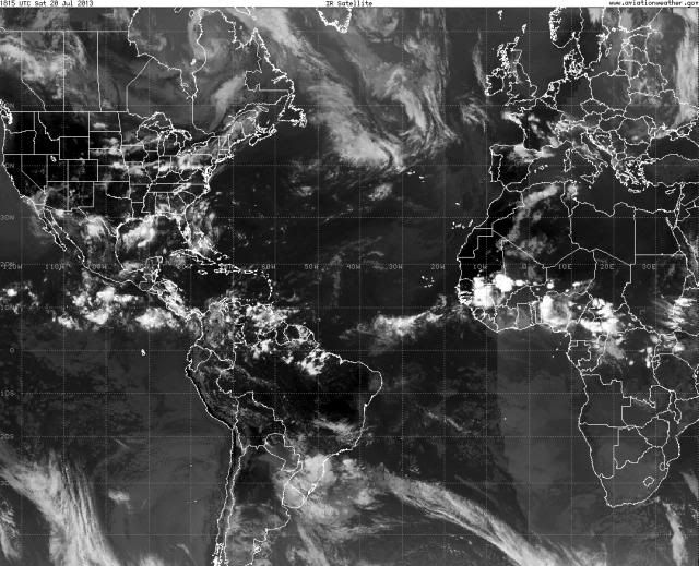
Here is the view of Africa.


0 likes
Visit the Caribbean-Central America Weather Thread where you can find at first post web cams,radars
and observations from Caribbean basin members Click Here
and observations from Caribbean basin members Click Here
-
ninel conde
- SFLcane
- S2K Supporter

- Posts: 10281
- Age: 48
- Joined: Sat Jun 05, 2010 1:44 pm
- Location: Lake Worth Florida
Re: African "bear watch": E Atlantic development? (Models here)
A bit to north in latitude for my liking.
Also take a look at this

Also take a look at this

0 likes
-
floridasun78
- Category 5

- Posts: 3755
- Joined: Sun May 17, 2009 10:16 pm
- Location: miami fl
Global Model Runs Discussion
we need see wave look by next wed we have sal and shear look at too see sal drop and shear too that now all over tropical speicaly by carribbean
0 likes
- cycloneye
- Admin

- Posts: 149469
- Age: 69
- Joined: Thu Oct 10, 2002 10:54 am
- Location: San Juan, Puerto Rico
Re: African "bear watch": E Atlantic development? (Models here)
SFLcane wrote:A bit to north in latitude for my liking.
Also take a look at this
http://tropic.ssec.wisc.edu/real-time/sal/splitEW.jpg
Is not that convection that you are looking at but the one more south behind. The pouch people just updated P12L.
P12L
10N, 1W
700 hPa
ECMWF: The hovmoller signal is quite distinct. However, tracking a pouch is more difficult. For the first couple days, I track a tiny OW max (one of many over west Africa). Upon reaching the Atlantic, P12L becomes difficult to track, with little to no OW max or trough in the immediate vicinity. About a day later, a circulation is definitely spinning off the African coast, in roughly the area where P12L should be, but it never has a clear center, and the fact that P12L weakens so much during the middle portion of the forecast would make for a few too many "guess" points to get to this circulation. I stop tracking at the coast, but keep in mind that ECMWF does attempt to spin up something off the coast not long thereafter.
GFS: Easily tracked pouch the entire 120 hours. P11L, which is west of P12L, weakens as P12L approaches it. OW increases as P12L moves off of Africa.
UKMET: While ECMWF is only hinting at starting to agree with the bullish GFS, UKMET has jumped on the bandwagon. (Interesting since UKMET had no positions at all for P12 in yesterday's 00Z forecast.) UKMET does weaken P12L a little as it leaves Africa, as well as on Day 5 over the central Atlantic, but otherwise, UKMET depicts a distinct pouch all 120 hours.
NAVGEM:
HWRF-GEN:
ECMWF -9.0 v700 48h
GFS -9.1 v700 120h
UKMET -9.8 v700 120h
NAVGEM ---- ---- ---h
HWGEN ---- ---- ---h
http://www.met.nps.edu/~mtmontgo/storms2013/P12L.html

0 likes
Visit the Caribbean-Central America Weather Thread where you can find at first post web cams,radars
and observations from Caribbean basin members Click Here
and observations from Caribbean basin members Click Here
-
HurricaneTracker2031
- Tropical Storm

- Posts: 248
- Age: 26
- Joined: Fri Jul 19, 2013 7:20 pm
- Location: Pembroke Pines, FL, USA
- Contact:
Re: African "bear watch": E Atlantic development?
Last edited by HurricaneTracker2031 on Sat Jul 20, 2013 4:35 pm, edited 2 times in total.
0 likes
SHORT VERSION OF DISCLAIMER: THIS SITE LINK BELOW IS NOT AN OFFICIAL FORECASTING OFFICE AND SHOULD NOT BE USED TO MAKE ANY EMERGENCY DECISIONS....
http://www.macstropicalweather.weebly.com
http://www.macstropicalweather.weebly.com
Who is online
Users browsing this forum: No registered users and 233 guests


