Disturbed weather in Yucatan,moves to SW GOM (Is Invest 95L)

This is the general tropical discussion area. Anyone can take their shot at predicting a storms path.

Moderator: S2k Moderators

Forum rules

The posts in this forum are NOT official forecasts and should not be used as such. They are just the opinion of the poster and may or may not be backed by sound meteorological data. They are NOT endorsed by any professional institution or STORM2K. For official information, please refer to products from the National Hurricane Center and National Weather Service.

Help Support Storm2K
Message
Author
User avatar
gatorcane
S2K Supporter
S2K Supporter
Posts: 23689
Age: 47
Joined: Sun Mar 13, 2005 3:54 pm
Location: Boca Raton, FL

#61 Postby gatorcane » Mon Sep 16, 2013 7:56 am

There is certainly alot of juicy tropical moisture all across the Western Caribbean, Yucatan, and SW Gulf, and over Florida. My hunch is that something does try to spin up possibly starting this weekend or early next week. The GFS and ECMWF still show some broad low developing out of this and moving NE. I wonder if these models are downplaying things some and we get a more bonafied tropical system to develop out of this?

Image

The posts in this forum are NOT official forecast and should not be used as such. They are just the opinion of the poster and may or may not be backed by sound meteorological data. They are NOT endorsed by any professional institution or storm2k.org. For official information, please refer to the NHC and NWS products.
0 likes   

User avatar
Blown Away
S2K Supporter
S2K Supporter
Posts: 10140
Joined: Wed May 26, 2004 6:17 am

Re: Disturbed weather in NW Caribbean,moves to SW GOM - 0% - 20%

#62 Postby Blown Away » Mon Sep 16, 2013 8:16 am

:uarrow: The table seems set, but it's hard to go against the GFS/Euro and they both show a big braod wet mess moving generally NE and don't show a well developed system...
0 likes   
Hurricane Eye Experience: David 79, Irene 99, Frances 04, Jeanne 04, Wilma 05... EYE COMING MY WAY IN 2024…
Hurricane Brush Experience: Andrew 92, Erin 95, Floyd 99, Matthew 16, Irma 17, Ian 22, Nicole 22…

User avatar
wxman57
Moderator-Pro Met
Moderator-Pro Met
Posts: 22951
Age: 67
Joined: Sat Jun 21, 2003 8:06 pm
Location: Houston, TX (southwest)

Re: Disturbed weather in NW Caribbean,moves to SW GOM - 0% - 20%

#63 Postby wxman57 » Mon Sep 16, 2013 8:41 am

I don't think this weak disturbance in the NW Caribbean will develop. It will likely move into Mexico in a few days. Way too much shear there now. But look toward the area from the NW Caribbean to east of the Bahamas by this weekend. Euro does develop a TS east of the Bahamas by Saturday, takes it NE and toward eastern Newfoundland by next Tuesday as an extratropical storm. However, the Euro continues to indicate moisture and lower pressure in the Gulf and NW Caribbean in its wake.
0 likes   

underthwx
Category 5
Category 5
Posts: 2351
Joined: Sat Jul 30, 2011 2:14 pm
Location: Brazoria County Texas

Re: Disturbed weather in NW Caribbean,moves to SW GOM - 0% - 20%

#64 Postby underthwx » Mon Sep 16, 2013 8:53 am

wxman57 wrote:I don't think this weak disturbance in the NW Caribbean will develop. It will likely move into Mexico in a few days. Way too much shear there now. But look toward the area from the NW Caribbean to east of the Bahamas by this weekend. Euro does develop a TS east of the Bahamas by Saturday, takes it NE and toward eastern Newfoundland by next Tuesday as an extratropical storm. However, the Euro continues to indicate moisture and lower pressure in the Gulf and NW Caribbean in its wake.


Meaning development possible in the Gulf next week?
0 likes   

stormlover2013

Re: Disturbed weather in NW Caribbean,moves to SW GOM - 0% - 20%

#65 Postby stormlover2013 » Mon Sep 16, 2013 9:33 am

you can't trust a model 240 hrs out on where something might go but what you can trust is it showing something that could develop out in GOM
0 likes   

jlauderdal
S2K Supporter
S2K Supporter
Posts: 7177
Joined: Wed May 19, 2004 5:46 am
Location: NE Fort Lauderdale
Contact:

Re: Disturbed weather in NW Caribbean,moves to SW GOM - 0% - 20%

#66 Postby jlauderdal » Mon Sep 16, 2013 9:53 am

Blown Away wrote::uarrow: The table seems set, but it's hard to go against the GFS/Euro and they both show a big braod wet mess moving generally NE and don't show a well developed system...


the broad wet mess scenario seems more likely then the text book tropical system...sunny and dry south of Palm Beach Co for the weekend, big wet mess north of Palm Beach and points north.. :wink:
0 likes   

User avatar
ronjon
Category 5
Category 5
Posts: 4811
Joined: Fri Aug 19, 2005 5:17 pm
Location: Hernando Beach, FL

Re: Disturbed weather in NW Caribbean,moves to SW GOM - 0% - 20%

#67 Postby ronjon » Mon Sep 16, 2013 11:42 am

Latest 12z GFS model run looks like a sheared frontal mess in the NE GOM with two low pressure systems in 7 days.
0 likes   

User avatar
gatorcane
S2K Supporter
S2K Supporter
Posts: 23689
Age: 47
Joined: Sun Mar 13, 2005 3:54 pm
Location: Boca Raton, FL

Re: Disturbed weather in NW Caribbean,moves to SW GOM - 0% - 20%

#68 Postby gatorcane » Mon Sep 16, 2013 12:30 pm

ronjon wrote:Latest 12z GFS model run looks like a sheared frontal mess in the NE GOM with two low pressure systems in 7 days.


Yeah I saw that. That is quite a front! Looks more like something you would see in the late October or early November timeframe than September...

Season ending cold front I wonder (will this front usher in the westerlies for good across the GOM and Florida)?
0 likes   

User avatar
cycloneye
Admin
Admin
Posts: 143867
Age: 68
Joined: Thu Oct 10, 2002 10:54 am
Location: San Juan, Puerto Rico

Re: Disturbed weather in NW Caribbean,moves to SW GOM - 0% - 20%

#69 Postby cycloneye » Mon Sep 16, 2013 12:38 pm

2 PM TWO:

AN AREA OF DISTURBED WEATHER LOCATED OVER THE NORTHWESTERN
CARIBBEAN SEA IS FORECAST TO MOVE WESTWARD OR WEST-NORTHWESTWARD
ACROSS THE YUCATAN PENINSULA AND INTO THE SOUTHWESTERN GULF OF
MEXICO DURING THE NEXT COUPLE OF DAYS. THIS SYSTEM HAS A LOW
CHANCE...NEAR 0 PERCENT...OF BECOMING A TROPICAL CYCLONE DURING THE
NEXT 48 HOURS. AFTER THAT...ENVIRONMENTAL CONDITIONS ARE FORECAST
TO BE MARGINALLY CONDUCIVE FOR SLOW DEVELOPMENT...AND THIS SYSTEM
HAS A LOW CHANCE...20 PERCENT...OF BECOMING A TROPICAL CYCLONE
DURING THE NEXT 5 DAYS.
0 likes   
Visit the Caribbean-Central America Weather Thread where you can find at first post web cams,radars
and observations from Caribbean basin members Click Here

User avatar
HurricaneBelle
S2K Supporter
S2K Supporter
Posts: 1169
Joined: Sun Aug 27, 2006 6:12 pm
Location: Clearwater, FL

Re: Disturbed weather in NW Caribbean,moves to SW GOM - 0% - 20%

#70 Postby HurricaneBelle » Mon Sep 16, 2013 12:52 pm

gatorcane wrote:
ronjon wrote:Latest 12z GFS model run looks like a sheared frontal mess in the NE GOM with two low pressure systems in 7 days.


Yeah I saw that. That is quite a front! Looks more like something you would see in the late October or early November timeframe than September...

Season ending cold front I wonder (will this front usher in the westerlies for good across the GOM and Florida)?


I can't remember a season-ending cold front in Florida in September in my 37 years living here.
0 likes   

User avatar
WPBWeather
S2K Supporter
S2K Supporter
Posts: 535
Age: 66
Joined: Thu Jul 18, 2013 12:33 pm

Re: Disturbed weather in NW Caribbean,moves to SW GOM - 0% - 20%

#71 Postby WPBWeather » Mon Sep 16, 2013 1:15 pm

HurricaneBelle wrote:
gatorcane wrote:
ronjon wrote:Latest 12z GFS model run looks like a sheared frontal mess in the NE GOM with two low pressure systems in 7 days.


Yeah I saw that. That is quite a front! Looks more like something you would see in the late October or early November timeframe than September...

Season ending cold front I wonder (will this front usher in the westerlies for good across the GOM and Florida)?


I can't remember a season-ending cold front in Florida in September in my 37 years living here.


You are quite correct. I have lived in FL longer than you and there is not a season ending front in sight for Sept.
0 likes   

Dean4Storms
S2K Supporter
S2K Supporter
Posts: 6358
Age: 62
Joined: Sun Aug 31, 2003 1:01 pm
Location: Miramar Bch. FL

#72 Postby Dean4Storms » Mon Sep 16, 2013 1:37 pm

Well that circulation in the NW Carib. Sea near the northern coast of Belize has as much organization at this point as 93L did when it was near that location. Need to watch this once it reaches the BOC.
0 likes   

User avatar
Blown Away
S2K Supporter
S2K Supporter
Posts: 10140
Joined: Wed May 26, 2004 6:17 am

Re: Disturbed weather in NW Caribbean,moves to SW GOM - 0% - 20%

#73 Postby Blown Away » Mon Sep 16, 2013 1:46 pm
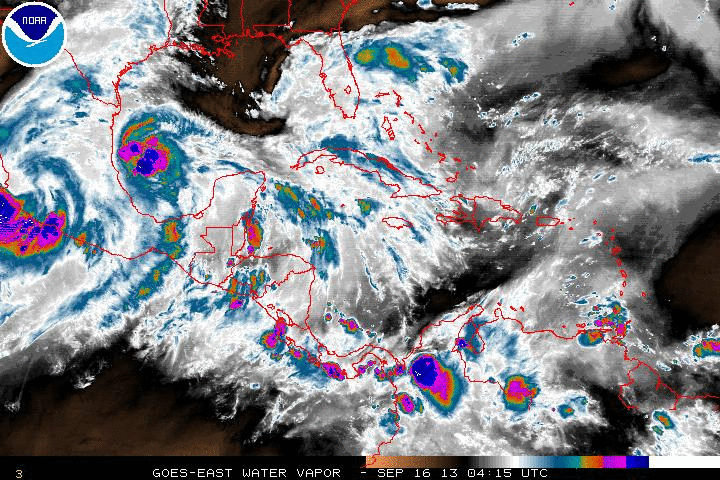
jlauderdal wrote:
Blown Away wrote::uarrow: The table seems set, but it's hard to go against the GFS/Euro and they both show a big braod wet mess moving generally NE and don't show a well developed system...


the broad wet mess scenario seems more likely then the text book tropical system...sunny and dry south of Palm Beach Co for the weekend, big wet mess north of Palm Beach and points north.. :wink:


It's from all that clean living for the points south of PB... :lol:
0 likes   
Hurricane Eye Experience: David 79, Irene 99, Frances 04, Jeanne 04, Wilma 05... EYE COMING MY WAY IN 2024…
Hurricane Brush Experience: Andrew 92, Erin 95, Floyd 99, Matthew 16, Irma 17, Ian 22, Nicole 22…

jlauderdal
S2K Supporter
S2K Supporter
Posts: 7177
Joined: Wed May 19, 2004 5:46 am
Location: NE Fort Lauderdale
Contact:

Re: Disturbed weather in NW Caribbean,moves to SW GOM - 0% - 20%

#74 Postby jlauderdal » Mon Sep 16, 2013 1:56 pm

Blown Away wrote:
jlauderdal wrote:
Blown Away wrote::uarrow: The table seems set, but it's hard to go against the GFS/Euro and they both show a big braod wet mess moving generally NE and don't show a well developed system...


the broad wet mess scenario seems more likely then the text book tropical system...sunny and dry south of Palm Beach Co for the weekend, big wet mess north of Palm Beach and points north.. :wink:


It's from all that clean living for the points south of PB... :lol:


haha..dade and broward county, the bastion of clean living, there is a good reason why the golfers choose your neck of the woods in which to reside....back to the weather, seems like everyone in central and sofla in for wet weather the next 7-10 days
0 likes   

User avatar
wxman57
Moderator-Pro Met
Moderator-Pro Met
Posts: 22951
Age: 67
Joined: Sat Jun 21, 2003 8:06 pm
Location: Houston, TX (southwest)

Re:

#75 Postby wxman57 » Mon Sep 16, 2013 1:58 pm

Dean4Storms wrote:Well that circulation in the NW Carib. Sea near the northern coast of Belize has as much organization at this point as 93L did when it was near that location. Need to watch this once it reaches the BOC.


That's true, but conditions in its path are not nearly as favorable as they were for Ingrid. Lots of shear the next 2-3 days.
0 likes   

User avatar
PTrackerLA
Category 5
Category 5
Posts: 5276
Age: 41
Joined: Thu Oct 10, 2002 8:40 pm
Location: Lafayette, LA

Re: Disturbed weather in NW Caribbean,moves to SW GOM - 0% - 20%

#76 Postby PTrackerLA » Mon Sep 16, 2013 2:21 pm

12z Euro takes vorticity into the BOC where a possible depression eventually forms and lingers around through day 10 while gradually getting stronger. It also develops a system off the east coast of Florida around the 26th. Man what is it with the BOC this year? :lol:
0 likes   

Dean4Storms
S2K Supporter
S2K Supporter
Posts: 6358
Age: 62
Joined: Sun Aug 31, 2003 1:01 pm
Location: Miramar Bch. FL

Re: Re:

#77 Postby Dean4Storms » Mon Sep 16, 2013 3:03 pm

wxman57 wrote:
Dean4Storms wrote:Well that circulation in the NW Carib. Sea near the northern coast of Belize has as much organization at this point as 93L did when it was near that location. Need to watch this once it reaches the BOC.


That's true, but conditions in its path are not nearly as favorable as they were for Ingrid. Lots of shear the next 2-3 days.


True, but you know the reputation of the BOC if it is sitting there for a few days, one little window of favorable conditions and boom. Might need to take into account upwelling at this point in the BOC, might have some effect.
0 likes   

Stormcenter
S2K Supporter
S2K Supporter
Posts: 6677
Joined: Wed Sep 03, 2003 11:27 am
Location: Houston, TX

Re: Disturbed weather in NW Caribbean,moves to SW GOM - 0% - 20%

#78 Postby Stormcenter » Mon Sep 16, 2013 4:03 pm

This afternoon's outlook from NWS New Orleans.

LONG TERM...
UPPER LEVEL PATTERN OVER THE NEXT WEEK IS REALLY VERY SIMILAR TO
LAST WEEK. WEAK UPPER LEVEL RIDGE IS CURRENTLY TRYING TO BUILD
ACROSS THE SOUTHEASTERN UNITED STATES. ABUNDANT MOISTURE REMAINS IN
PLACE JUST SOUTH OF THE GULF COAST ACROSS THE ENTIRE GULF OF MEXICO.
THE SOUTHERN EDGE OF THE HIGH SHOULD BE FAIRLY WEAK AND LIKELY BEGIN
ALLOWING MORE OF THIS MOISTURE TO MOVE INTO THE CWA. EXPECTING POPS
TO PROGRESSIVELY INCREASE EACH DAY THIS WEEK WITH CHANCE POPS
THROUGH MID WEEK AND HIGHER AFTER THAT. A TROPICAL WAVE IN THE
WESTERN CARIBBEAN WILL BE SLOWLY TRACKING WESTWARD ACROSS THE
YUCATAN INTO THE BAY OF CAMPECHE AFTER MID WEEK. AT THE SAME
TIME...AN UPPER TROUGH WILL BE SWINGING ACROSS NORTHERN SECTIONS OF
THE COUNTRY. MOISTURE FROM THE TROPICAL FEATURE WILL GET DRAWN
NORTHWARD TOWARDS THE APPROACHING FRONTAL BOUNDARY.
IT APPEARS THAT
THIS WILL BRING RAIN CHANCES UP EVEN MORE BY THE BEGINNING OF THE
WEEKEND WITH AT LEAST 50 PCT CHANCE ON SATURDAY. MAY NEED HIGHER
RAIN CHANCES. LOCALLY HEAVY RAIN WILL BE POSSIBLE AS MODEL SOUNDINGS
INDICATE PRECIP WATER VALUES OF NEAR 2.5 INCHES. BOTH GFS AND ECMWF
AGREE THAT THE TROUGH WILL BE STRONG ENOUGH TO PUSH THE ASSOCIATED
COLD FRONT TO THE COAST. WAITING FOR MORE RUN TO RUN MODEL
CONSISTENCY BEFORE PULLING RAIN CHANCES DOWN TO LOW ON SUNDAY. MAY
BE MORE OF A TIMING ISSUE.
0 likes   

User avatar
sfwx
Category 1
Category 1
Posts: 371
Age: 59
Joined: Thu Sep 04, 2003 1:53 pm
Location: Rural St. Lucie County, Fl

Re: Disturbed weather in NW Caribbean,moves to SW GOM - 0% - 20%

#79 Postby sfwx » Mon Sep 16, 2013 5:46 pm

000
FXUS62 KMLB 161916
AFDMLB

AREA FORECAST DISCUSSION
NATIONAL WEATHER SERVICE MELBOURNE FL
315 PM EDT MON SEP 16 2013

.DISCUSSION...


BOTH MODELS CONTINUE TO SHOW THE DEVELOPMENT OF A BROAD...PERHAPS
DOUBLE BARRELED (BAROCLINIC NORTH/TROPICAL SOUTH) AREA OF LOW
PRESSURE OVER THE GOMEX LATE SAT/EARLY SUN...THEN LIFT THE FEATURE
OUT IN THE GENERAL VICINITY OF THE ERN OR SERN GOMEX...AND OUT THRU
FL AND THE BAHAMAS AHEAD OF A MID TO UPPER LEVEL TROUGH. SCENARIO
LOOKS PRETTY COMPLEX ATTM AND BEING BEYOND DAY 5...UNCERTAINTY W/R/T
TIMING...INTENSITY AND STRUCTURE OF ANY LOW THAT WOULD POTENTIALLY
IMPACT THE AREA IS QUITE LARGE. BUT REGARDLESS OF HOW THIS FEATURE
DEVELOPS...IT APPEARS WE ARE HEADED TOWARD WETTER PERIOD SUN-TUE.


FORECAST/AVIATION...CRISTALDI
IMPACT WX/RADAR....SPRATT/SEDLOCK
0 likes   

Sanibel
Category 5
Category 5
Posts: 10375
Joined: Mon Aug 30, 2004 11:06 pm
Location: Offshore SW Florida

Re: Disturbed weather in NW Caribbean,moves to SW GOM - 0% - 20%

#80 Postby Sanibel » Mon Sep 16, 2013 6:13 pm

Must be a 2013 hot spot trying to pump out another one.
0 likes   


Return to “Talkin' Tropics”

Who is online

Users browsing this forum: RomP and 218 guests