


Eastern Atlantic Tropical Wave near 27W (Invest 97L is up)
Moderator: S2k Moderators
Forum rules

The posts in this forum are NOT official forecasts and should not be used as such. They are just the opinion of the poster and may or may not be backed by sound meteorological data. They are NOT endorsed by any professional institution or STORM2K. For official information, please refer to products from the National Hurricane Center and National Weather Service.
Re: Eastern Atlantic Tropical Wave near 27W (06Z)
12z Euro has the track of this tropical wave a little further south & a little slower, across the northern Leeward Islands into P.R.
0 likes
Re: Eastern Atlantic Tropical Wave near 27W (06Z)
12z Euro has the ridge to the north of the tropical wave by this weekend stronger on this run, thus a little more southerly track. Notice the higher than average heights across eastern Canada.

0 likes
-
TheStormExpert
Re: Eastern Atlantic Tropical Wave near 27W (06Z)
2 likes

Re: Eastern Atlantic Tropical Wave near 27W (06Z)
12z Euro tracks this wave over Puerto Rico and into South Florida. Certainly one to watch, especially if it tracks north of PR.
1 likes
-
Gustywind

- Category 5

- Posts: 12334
- Joined: Mon Sep 03, 2007 7:29 am
- Location: Baie-Mahault, GUADELOUPE
Re: Eastern Atlantic Tropical Wave near 27W (06Z)
000
AXNT20 KNHC 271741 CCA
TWDAT
Tropical wave in the east Tropical Atlantic west of the Cape
Verde Islands extends along 28W/29W from 10N-19N moving west 10
to 15 kt over the past 24 hours. Wave coincides with a 700 mb
low/trough as depicted in the global models and is embedded
within a high amplitude surge of moisture as seen on the SSMI
Total Precipitable Water imagery. Clusters of scattered moderate
convection are from 8N-13N between 24W-34W.
0 likes


-
TheStormExpert
Re: Eastern Atlantic Tropical Wave near 27W (06Z)
Here is the latest 12z JMA run.

By the way, what does the latest 12z UKMET show?
By the way, what does the latest 12z UKMET show?
0 likes
Re: Eastern Atlantic Tropical Wave near 27W (06Z)
12z Euro shows a very good UL wind pattern on top of the TW as it approaches the Leeward Islands.

Last edited by NDG on Wed Jul 27, 2016 2:07 pm, edited 1 time in total.
0 likes
-
TheStormExpert
Re: Eastern Atlantic Tropical Wave near 27W (06Z)
NDG wrote:12z Euro shows a very good UL wind pattern on top of the TW as it approaches the Leeward Islands.
So it seems at the moment that dry stable air and land interaction are the only two inhibitors.
0 likes
-
Gustywind
- Category 5
- Posts: 12334
- Joined: Mon Sep 03, 2007 7:29 am
- Location: Baie-Mahault, GUADELOUPE
Re: Eastern Atlantic Tropical Wave near 27W (06Z)
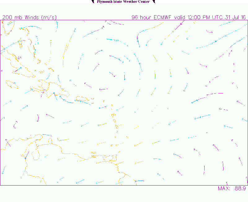
NDG wrote:12z Euro shows a very good UL wind pattern on top of the TW as it approaches the Leeward Islands.
http://vortex.plymouth.edu/gifs/160727185641.gif
Ok thanks and what does it mean in your opinion?
0 likes
Re: Eastern Atlantic Tropical Wave near 27W (06Z)
TheStormExpert wrote:NDG wrote:12z Euro shows a very good UL wind pattern on top of the TW as it approaches the Leeward Islands.
So it seems at the moment that dry stable air and land interaction are the only two inhibitors.
Yes, but, as we know that if wind shear is not going to be a big problem then the dry air around it may not get to it. The biggest problem for it that I see is going to be its fast track before the Leeward Islands and possible land interaction with P.R. & Hispaniola after that.
0 likes
Re: Eastern Atlantic Tropical Wave near 27W (06Z)
Gustywind wrote:NDG wrote:12z Euro shows a very good UL wind pattern on top of the TW as it approaches the Leeward Islands.
http://vortex.plymouth.edu/gifs/160727185641.gif
Ok thanks and what does it mean in your opinion?
Windshear will be minimal.
0 likes
-
TheStormExpert
Re: Eastern Atlantic Tropical Wave near 27W (06Z)
NDG wrote:TheStormExpert wrote:NDG wrote:12z Euro shows a very good UL wind pattern on top of the TW as it approaches the Leeward Islands.
So it seems at the moment that dry stable air and land interaction are the only two inhibitors.
Yes, but, as we know that if wind shear is not going to be a big problem then the dry air around it may not get to it. The biggest problem for it that I see is going to be its fast track before the Leeward Islands and possible land interaction with P.R. & Hispaniola after that.
I'm guessing fast trade winds are still a problem?
0 likes
-
Gustywind
- Category 5
- Posts: 12334
- Joined: Mon Sep 03, 2007 7:29 am
- Location: Baie-Mahault, GUADELOUPE
Re: Eastern Atlantic Tropical Wave near 27W (06Z)
NDG wrote:Gustywind wrote:NDG wrote:12z Euro shows a very good UL wind pattern on top of the TW as it approaches the Leeward Islands.
http://vortex.plymouth.edu/gifs/160727185641.gif
Ok thanks and what does it mean in your opinion?
Windshear will be minimal.
Ok thanks to you. I was guessing that too
0 likes
-
Hurricaneman

- Category 5
- Posts: 7404
- Age: 45
- Joined: Tue Aug 31, 2004 3:24 pm
- Location: central florida
Re: Eastern Atlantic Tropical Wave near 27W (06Z)
will need to watch this one due to some model support although weak and has a good pattern for some development and may need to be watched in Florida and the Southeastern US
The posts in this forum are NOT official forecast and should not be used as such. They are just the opinion of the poster and may or may not be backed by sound meteorological data. They are NOT endorsed by any professional institution or STORM2K. For official information, please refer to products from the National Hurricane Center and National Weather Service
The posts in this forum are NOT official forecast and should not be used as such. They are just the opinion of the poster and may or may not be backed by sound meteorological data. They are NOT endorsed by any professional institution or STORM2K. For official information, please refer to products from the National Hurricane Center and National Weather Service
1 likes
-
Gustywind
- Category 5
- Posts: 12334
- Joined: Mon Sep 03, 2007 7:29 am
- Location: Baie-Mahault, GUADELOUPE
Re: Eastern Atlantic Tropical Wave near 27W (06Z)
000
AXNT20 KNHC 271741 CCA
TWDAT
Tropical Weather Discussion...correction for satellite time
NWS National Hurricane Center Miami FL
205 PM EDT WED JUL 27 2016
Tropical wave in the east Tropical Atlantic west of the Cape
Verde Islands extends along 28W/29W from 10N-19N moving west 10
to 15 kt over the past 24 hours. Wave coincides with a 700 mb
low/trough as depicted in the global models and is embedded
within a high amplitude surge of moisture as seen on the SSMI
Total Precipitable Water imagery. Clusters of scattered moderate
convection are from 8N-13N between 24W-34W.
0 likes


Re: Eastern Atlantic Tropical Wave near 27W (Pouch 06L)
Ends up in the Gulf eventually on the 00z GFS, no development.
Meanwhile, the Canadian:

Meanwhile, the Canadian:
0 likes

Re: Eastern Atlantic Tropical Wave near 27W (Pouch 06L)
Euro still showing nothing, which in all likelihood will continue to be the case for the next few weeks. GFS on the other hand has gone completely nuts with a system with hurricane winds at 850MB developing over Africa in the long range.
1 likes
The above post is not official and should not be used as such. It is the opinion of the poster and may or may not be backed by sound meteorological data. It is not endorsed by any professional institution or storm2k.org. For official information, please refer to the NHC and NWS products.


Re: Eastern Atlantic Tropical Wave near 27W (Pouch 06L)
Here's that mad solution:

It develops the wave into a tropical storm while still over Africa, what the heck?
It develops the wave into a tropical storm while still over Africa, what the heck?
0 likes

Who is online
Users browsing this forum: No registered users and 188 guests