Strong Tropical Wave SSE of Cabo Verde Islands (Is Invest 92L)

This is the general tropical discussion area. Anyone can take their shot at predicting a storms path.

Moderator: S2k Moderators

Forum rules

The posts in this forum are NOT official forecasts and should not be used as such. They are just the opinion of the poster and may or may not be backed by sound meteorological data. They are NOT endorsed by any professional institution or STORM2K. For official information, please refer to products from the National Hurricane Center and National Weather Service.

Help Support Storm2K
Message
Author
User avatar
FireRat
Category 5
Category 5
Posts: 1239
Age: 37
Joined: Sun Sep 26, 2010 11:38 pm
Location: North Carolina

Re: Strong Tropical Wave emerging West Africa

#61 Postby FireRat » Thu Jul 23, 2020 11:30 pm

Hurricaneman wrote:All models are on board for development except the GFS, I’d bet against the GFS on this alone but also moves this wave much faster than every other model. I would think the GFS will come around to the other models the next day or 2 or it will either be right and all other models wrong or the GFS will bust badly again


True indeed, and given the GFS's track record thus far, I'd say it's questionable and we should take it with a grain of salt this season. Perhaps the corrections they made to it got rid of the phantoms but in the process also tilted the balance the other way, possibly being too "corrected" or "rigid" and leading to sniffing out fewer storms than reality. Time will tell, but yeah, I'd say the other models are probably right about this one.
1 likes   
Georges '98, Irene '99, Frances '04, Jeanne '04, Katrina '05, Wilma '05, Gustav '08, Isaac '12, Matthew '16, Florence '18, Michael '18, Ian '22

User avatar
Hammy
Category 5
Category 5
Posts: 5849
Age: 41
Joined: Fri May 25, 2012 5:25 pm
Contact:

Re: Strong Tropical Wave emerging West Africa

#62 Postby Hammy » Thu Jul 23, 2020 11:50 pm

Hurricaneman wrote:All models are on board for development except the GFS, I’d bet against the GFS on this alone but also moves this wave much faster than every other model. I would think the GFS will come around to the other models the next day or 2 or it will either be right and all other models wrong or the GFS will bust badly again


CMC has backed off and has it flattening out in a few days.
0 likes   
The above post is not official and should not be used as such. It is the opinion of the poster and may or may not be backed by sound meteorological data. It is not endorsed by any professional institution or storm2k.org. For official information, please refer to the NHC and NWS products.

AutoPenalti
Category 5
Category 5
Posts: 4029
Age: 28
Joined: Mon Aug 17, 2015 4:16 pm
Location: Ft. Lauderdale, Florida

Re: Strong Tropical Wave emerging West Africa

#63 Postby AutoPenalti » Thu Jul 23, 2020 11:53 pm

FWIW, Canadian backs off development. ICON may follow suit.
0 likes   
The posts in this forum are NOT official forecasts and should not be used as such. They are just the opinion of the poster and may or may not be backed by sound meteorological data. They are NOT endorsed by any professional institution or STORM2K. For official information, please refer to products from the NHC and NWS.


Model Runs Cheat Sheet:
GFS (5:30 AM/PM, 11:30 AM/PM)
HWRF, GFDL, UKMET, NAVGEM (6:30-8:00 AM/PM, 12:30-2:00 AM/PM)
ECMWF (1:45 AM/PM)

TCVN
is a weighted averaged

User avatar
ColdMiser123
Professional-Met
Professional-Met
Posts: 897
Age: 28
Joined: Mon Sep 26, 2016 3:26 pm
Location: Northeast US

Re: Strong Tropical Wave emerging West Africa

#64 Postby ColdMiser123 » Fri Jul 24, 2020 12:07 am

NEW TROPICAL CYCLONE FORECAST TO DEVELOP AFTER 102 HOURS
FORECAST POSITION AT T+102 : 13.3N 51.4W

LEAD CENTRAL MAXIMUM WIND
VERIFYING TIME TIME POSITION PRESSURE (MB) SPEED (KNOTS)
-------------- ---- -------- ------------- -------------
1200UTC 28.07.2020 108 13.2N 53.7W 1008 33
0000UTC 29.07.2020 120 14.1N 57.5W 1006 36
1200UTC 29.07.2020 132 14.7N 61.6W 1003 39
0000UTC 30.07.2020 144 15.6N 65.2W 999 44
1 likes   
B.S., M.S., Meteorology & Atmospheric Science

sma10
Category 5
Category 5
Posts: 1710
Joined: Tue Aug 02, 2005 1:13 pm

Re: Strong Tropical Wave emerging West Africa

#65 Postby sma10 » Fri Jul 24, 2020 12:24 am

It's the North American models (GFS, CMC) versus European models (Icon, UK, Euro)
0 likes   

caneseddy
Category 5
Category 5
Posts: 1172
Joined: Fri Sep 03, 2004 9:31 pm
Location: Plantation, FL

Re: Strong Tropical Wave emerging West Africa

#66 Postby caneseddy » Fri Jul 24, 2020 12:26 am

ColdMiser123 wrote:NEW TROPICAL CYCLONE FORECAST TO DEVELOP AFTER 102 HOURS
FORECAST POSITION AT T+102 : 13.3N 51.4W

LEAD CENTRAL MAXIMUM WIND
VERIFYING TIME TIME POSITION PRESSURE (MB) SPEED (KNOTS)
-------------- ---- -------- ------------- -------------
1200UTC 28.07.2020 108 13.2N 53.7W 1008 33
0000UTC 29.07.2020 120 14.1N 57.5W 1006 36
1200UTC 29.07.2020 132 14.7N 61.6W 1003 39
0000UTC 30.07.2020 144 15.6N 65.2W 999 44


Has it entering the Caribbean heading WNW towards PR and Hispaniola. Seen that track many times

Let’s see if the Euro continues showing it
0 likes   

User avatar
Hurricaneman
Category 5
Category 5
Posts: 7349
Age: 44
Joined: Tue Aug 31, 2004 3:24 pm
Location: central florida

Re: Strong Tropical Wave emerging West Africa

#67 Postby Hurricaneman » Fri Jul 24, 2020 2:35 am

Euro has it by the Yucatán channel as a intense hurricane, basically North America models vs the world
0 likes   

Shell Mound
Category 5
Category 5
Posts: 2434
Age: 32
Joined: Thu Sep 07, 2017 3:39 pm
Location: St. Petersburg, FL → Scandinavia

Re: Strong Tropical Wave emerging West Africa

#68 Postby Shell Mound » Fri Jul 24, 2020 2:59 am

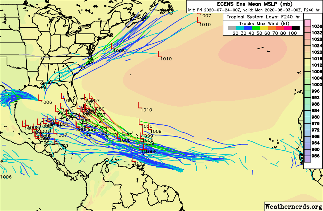
The past several runs of the EPS, including the latest, have been gradually trending toward a +NAO by day six, along with a westward extension or retrogression of the mid-level ridging over the Sargasso Sea, as mentioned previously. There are already hints of a cutoff low beginning to form over the lower Mississippi River valley over time. The overall evolution of the pattern would also tend to favour ridging over the Gulf of Alaska forming an Omega block with lows riding beneath and gradually being cut off. Overall, if a system were approaching the islands in this kind of pattern, it would likely pass over or very near Puerto Rico and then track toward the lower Bahamas and South Florida, given the retrogressive, blocky +NAO pattern. Most MH hits on Southeast FL during August/September tend to occur during +NAO periods. This trend needs to be watched closely. I think that future EPS runs may show westward shifts toward PR/S Bahamas/S FL, while the operational ECMWF drops its “Caribbean cruiser” in favour of a 1928- or Irma-type solution. Another possibility is a stair-stepping track into N FL or GA, similar to that of the 1898 hurricane. As of now, both the Yucatán and Carolinas-to-New-England solutions may be eclipsed.

 https://twitter.com/MJVentrice/status/1286446369465602053


 https://twitter.com/webberweather/status/1286503894462410752


 https://twitter.com/webberweather/status/1286506470708838400


1 likes   
CVW / MiamiensisWx / Shell Mound
The posts in this forum are NOT official forecasts and should not be used as such. They are just the opinion of the poster and may or may not be backed by sound meteorological data. They are NOT endorsed by any professional institution or STORM2K. For official information, please refer to products from the NHC and NWS.

User avatar
StruThiO
Category 3
Category 3
Posts: 821
Age: 25
Joined: Fri Sep 15, 2017 5:51 am
Location: Currently Portland, OR. Raised in Jax, FL.

Re: Strong Tropical Wave emerging West Africa

#69 Postby StruThiO » Fri Jul 24, 2020 3:59 am

00z EC...

Image
0 likes   

User avatar
StruThiO
Category 3
Category 3
Posts: 821
Age: 25
Joined: Fri Sep 15, 2017 5:51 am
Location: Currently Portland, OR. Raised in Jax, FL.

Re: Strong Tropical Wave emerging West Africa

#70 Postby StruThiO » Fri Jul 24, 2020 5:18 am

1 likes   

TheStormExpert

Re: Strong Tropical Wave emerging West Africa

#71 Postby TheStormExpert » Fri Jul 24, 2020 5:39 am

1 likes   

User avatar
SFLcane
S2K Supporter
S2K Supporter
Posts: 10162
Age: 47
Joined: Sat Jun 05, 2010 1:44 pm
Location: Lake Worth Florida

Re: Strong Tropical Wave emerging West Africa

#72 Postby SFLcane » Fri Jul 24, 2020 6:34 am

Yikes! :eek:

Image
4 likes   

User avatar
abajan
S2K Supporter
S2K Supporter
Posts: 4229
Joined: Sun Sep 07, 2003 5:10 am
Location: Barbados

Re: Strong Tropical Wave emerging West Africa

#73 Postby abajan » Fri Jul 24, 2020 7:01 am

Tropical Weather Outlook
NWS National Hurricane Center Miami FL
800 AM EDT Fri Jul 24 2020

For the North Atlantic...Caribbean Sea and the Gulf of Mexico:

The National Hurricane Center is issuing advisories on Tropical
Storm Gonzalo, located less than 600 miles east of the southern
Windward Islands.

The National Hurricane Center is also issuing advisories on
Tropical Storm Hanna, located over the west-central Gulf of Mexico
less than 300 miles east of Corpus Christi, Texas.

1. A tropical wave located about 300 miles southeast of the Cabo Verde
Islands is producing an area of cloudiness and disorganized
thunderstorms. The disturbance is expected move westward across the
tropical Atlantic during the next several days, and some gradual
development of this system is possible by early next week when it
reaches the western tropical Atlantic.
* Formation chance through 48 hours...low...near 0 percent.
* Formation chance through 5 days...low...30 percent.

Forecaster Stewart
0 likes   

User avatar
jfk08c
S2K Supporter
S2K Supporter
Posts: 203
Joined: Mon Jun 11, 2018 4:36 pm
Location: Lakeland, FL

Re: Strong Tropical Wave emerging West Africa

#74 Postby jfk08c » Fri Jul 24, 2020 7:12 am

SFLcane wrote:Yikes! :eek:

https://iili.io/dIKoG9.png


So if I remember correctly, a stronger storm is more influenced by atmospheric steering patterns. Which would explain why most of the runs heading towards Florida tend to be more intense. Would this be a correct assessment?
2 likes   

User avatar
aspen
Category 5
Category 5
Posts: 8812
Joined: Sat Oct 12, 2019 7:10 pm
Location: Connecticut, USA

Re: Strong Tropical Wave emerging West Africa

#75 Postby aspen » Fri Jul 24, 2020 7:50 am

StruThiO wrote:00z EC...

https://i.imgur.com/J3TgC9S.gif

The main Euro run has been keeping this system further south for a while now, so even if it doesn’t develop in 3-5 days, that wave might have the chance to become something in the western Caribbean.
0 likes   
Irene '11 Sandy '12 Hermine '16 5/15/2018 Derecho Fay '20 Isaias '20 Elsa '21 Henri '21 Ida '21

I am only a meteorology enthusiast who knows a decent amount about tropical cyclones. Look to the professional mets, the NHC, or your local weather office for the best information.

jlauderdal
S2K Supporter
S2K Supporter
Posts: 7177
Joined: Wed May 19, 2004 5:46 am
Location: NE Fort Lauderdale
Contact:

Re: Strong Tropical Wave emerging West Africa

#76 Postby jlauderdal » Fri Jul 24, 2020 8:14 am

SFLcane wrote:Yikes! :eek:

https://iili.io/dIKoG9.png

ridge appears to be firm, good bet to make it at least 75W

Gonzalo energy also has to be watched carefully for gulf development

we are in primetime at least a month early

ppe , hurricane supplies should be fortified
0 likes   

User avatar
DorkyMcDorkface
Category 3
Category 3
Posts: 819
Age: 27
Joined: Mon Sep 30, 2019 1:32 pm
Location: Mid-Atlantic

Re: Strong Tropical Wave emerging West Africa

#77 Postby DorkyMcDorkface » Fri Jul 24, 2020 8:24 am

This one definitely looks like trouble down the road. Because of its sprawling size it will likely take a little longer to consolidate wouldn't expect any significant development until it is past 40W or so (which is what the NHC appears to be anticipating). That being said, this will have a much more favorable environment to work with compared to Gonzalo (and its larger size will likely make it less vulnerable to any impediments).

Image
1 likes   
Please note the thougths expressed by this account are solely those of the user and are from a hobbyist perspective. For more comprehensive analysis, consult an actual professional meteorologist or meteorology agency.


Floyd 1999 | Isabel 2003 | Hanna 2008 | Irene 2011 | Sandy 2012 | Isaias 2020

User avatar
gatorcane
S2K Supporter
S2K Supporter
Posts: 23689
Age: 47
Joined: Sun Mar 13, 2005 3:54 pm
Location: Boca Raton, FL

Re: Strong Tropical Wave emerging West Africa

#78 Postby gatorcane » Fri Jul 24, 2020 8:27 am

Looks like the Euro, UKMET, and ICON show development while the GFS, CMC, and NAVGEM do not. There are a few GFS ensembles that show some weak development now but most continue to show nothing.
0 likes   

User avatar
JaxGator
Category 2
Category 2
Posts: 780
Joined: Sun Jun 12, 2016 3:33 pm
Location: Jacksonville Florida

Re: Strong Tropical Wave emerging West Africa

#79 Postby JaxGator » Fri Jul 24, 2020 8:44 am

gatorcane wrote:Looks like the Euro, UKMET, and ICON show development while the GFS, CMC, and NAVGEM do not. There are a few GFS ensembles that show some weak development now but most continue to show nothing.


Everyone on this forum doesn’t want a major hurricane season with potential landfalls, myself included and I’m sure that has gotten everyone a little anxious on might be to come. However, it’s not a good thing to completely ignore something that could develop regardless or a lot or no model support. Back on topic, this wave has more favorable conditions going for it than the over preforming daredevil Gonzalo (even that was impressive is to see). The lid has come off, I think it’s safe to say.
1 likes   
The posts or stuff said are NOT an official forecast. Please look to the NHC and NWS for official forecasts and products.

Floyd-1999, Frances-2004, Jeanne-2004, Fay-2008, Beryl-2012, Debby-2012, Colin-2016, Hermine-2016, Julia-2016, Matthew-2016, Irma-2017, Elsa-2021, Idalia-2023, Debby-2024, Helene-2024.


Go Gators! Go Jags!

User avatar
SouthFLTropics
Category 5
Category 5
Posts: 4236
Age: 49
Joined: Thu Aug 14, 2003 8:04 am
Location: Port St. Lucie, Florida

Re: Strong Tropical Wave emerging West Africa

#80 Postby SouthFLTropics » Fri Jul 24, 2020 8:45 am

gatorcane wrote:Looks like the Euro, UKMET, and ICON show development while the GFS, CMC, and NAVGEM do not. There are a few GFS ensembles that show some weak development now but most continue to show nothing.


The way the models are acting seems completely backwards from normal. Typically the GFS and CMC would be developing everything and the Euro and UKMET would be more conservative. Not sure what the GFS and CMC aren't seeing. Every indication is that this wave is going to be a problem. Meanwhile, the NAVGEM keeps wanting to develop Gonzalo further and send it into South Florida.

I guess that's what we get with it being 2020. Nothing is normal.
0 likes   
Fourth Generation Florida Native

Personal Storm History: David 79, Andrew 92, Erin 95, Floyd 99, Irene 99, Frances 04, Jeanne 04, Wilma 05, Matthew 16, Irma 17, Ian 22, Nicole 22, Milton 24


Return to “Talkin' Tropics”

Who is online

Users browsing this forum: No registered users and 94 guests