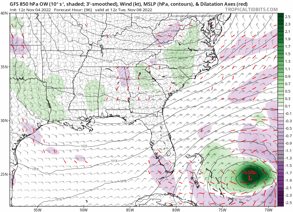
Wxman 57 disagrees big time, after spending about 30 seconds looking at the setup, im with 57 on this one.Blown Away wrote:
12z GFS very bullish… Cat 2 into SFL in 5-6 days…
Possible Development Near the GA/Bahamas (Is Invest 98L)
Moderator: S2k Moderators
Forum rules

The posts in this forum are NOT official forecasts and should not be used as such. They are just the opinion of the poster and may or may not be backed by sound meteorological data. They are NOT endorsed by any professional institution or STORM2K. For official information, please refer to products from the National Hurricane Center and National Weather Service.
-
jlauderdal
- S2K Supporter

- Posts: 7240
- Joined: Wed May 19, 2004 5:46 am
- Location: NE Fort Lauderdale
- Contact:
Re: RE: Re: Possible Development Near the GA/Bahamas Early Next Week (0/40)
1 likes
-
Blown Away

- S2K Supporter
- Posts: 10253
- Joined: Wed May 26, 2004 6:17 am
Re: RE: Re: Possible Development Near the GA/Bahamas Early Next Week (0/40)
jlauderdal wrote:Wxman 57 disagrees big time, after spending about 30 seconds looking at the setup, im with 57 on this one.Blown Away wrote:[url]https://i.postimg.cc/dtmN2Ssz/gfs-ow850-seus-fh96-198.gif [/url]
12z GFS very bullish… Cat 2 into SFL in 5-6 days…
I agree 100%, but it’s November and my reliable climatology methods don’t apply. When Kate was rolling in to South Florida many years ago I’m sure nobody said that will happen.
2 likes
Hurricane Eye Experience: David 79, Irene 99, Frances 04, Jeanne 04, Wilma 05… Hurricane Brush Experience: Andrew 92, Erin 95, Floyd 99, Matthew 16, Irma 17, Ian 22, Nicole 22…
Re: Possible Development Near the GA/Bahamas Early Next Week (0/40)
The 12Z CMC and UKMET both have a NW moving TS centered near Cape Canaveral at hour 144 (Thursday morning). Here is the 12Z UKMET:
NEW TROPICAL CYCLONE FORECAST TO DEVELOP AFTER 90 HOURS
FORECAST POSITION AT T+ 90 : 26.1N 71.5W
LEAD CENTRAL MAXIMUM WIND
VERIFYING TIME TIME POSITION PRESSURE (MB) SPEED (KNOTS)
-------------- ---- -------- ------------- -------------
1200UTC 08.11.2022 96 26.0N 72.6W 1007 32
0000UTC 09.11.2022 108 25.3N 74.0W 1007 35
1200UTC 09.11.2022 120 26.2N 75.1W 1006 39
0000UTC 10.11.2022 132 27.0N 78.1W 1004 40
1200UTC 10.11.2022 144 28.5N 80.8W 1003 42
2 likes
Personal Forecast Disclaimer:
The posts in this forum are NOT official forecasts and should not be used as such. They are just the opinion of the poster and may or may not be backed by sound meteorological data. They are NOT endorsed by any professional institution or storm2k.org. For official information, please refer to the NHC and NWS products.
The posts in this forum are NOT official forecasts and should not be used as such. They are just the opinion of the poster and may or may not be backed by sound meteorological data. They are NOT endorsed by any professional institution or storm2k.org. For official information, please refer to the NHC and NWS products.
-
tolakram
- Admin

- Posts: 20186
- Age: 62
- Joined: Sun Aug 27, 2006 8:23 pm
- Location: Florence, KY (name is Mark)
Re: Possible Development Near the GA/Bahamas Early Next Week (0/40)
ICON and GFS very similar, except for the strength. I like the NAVGEM, hurricane into Georgia. lol The poor NAVGEM.
1 likes
M a r k
- - - - -
Join us in chat: Storm2K Chatroom Invite. Android and IOS apps also available.
The posts in this forum are NOT official forecasts and should not be used as such. Posts are NOT endorsed by any professional institution or STORM2K.org. For official information and forecasts, please refer to NHC and NWS products.
-
Blown Away
- S2K Supporter
- Posts: 10253
- Joined: Wed May 26, 2004 6:17 am
Re: Possible Development Near the GA/Bahamas Early Next Week (0/40)
tolakram wrote:ICON and GFS very similar, except for the strength. I like the NAVGEM, hurricane into Georgia. lol The poor NAVGEM.
12z models really closing off the LLC compared to the big broad gyre in past runs.
0 likes
Hurricane Eye Experience: David 79, Irene 99, Frances 04, Jeanne 04, Wilma 05… Hurricane Brush Experience: Andrew 92, Erin 95, Floyd 99, Matthew 16, Irma 17, Ian 22, Nicole 22…

Re: Possible Development Near the GA/Bahamas Early Next Week (0/40)
Seeing some of the globals transitioning to a more well-developed tropical cyclone over the Bahamas. I'd say given early November and climatology, we probably shouldn't be worried. At the same time, its been a rather warm October and we haven't transitioned into a robust fall pattern with long wave troughs over the eastern US. Have to watch this one as waters around the Bahamas can crank these subtropical systems into full warm core.
3 likes

Re: Possible Development Near the GA/Bahamas Early Next Week (0/40)
The only model I want to know about the german model UCON the only model that had it going to upper Fort Myers from day 1.
0 likes
-
Category5Kaiju

- Category 5

- Posts: 4338
- Joined: Thu Dec 24, 2020 12:45 pm
- Location: Seattle during the summer, Phoenix during the winter
Re: Possible Development Near the GA/Bahamas Early Next Week (0/40)
ronjon wrote:Seeing some of the globals transitioning to a more well-developed tropical cyclone over the Bahamas. I'd say given early November and climatology, we probably shouldn't be worried. At the same time, its been a rather warm October and we haven't transitioned into a robust fall pattern with long wave troughs over the eastern US. Have to watch this one as waters around the Bahamas can crank these subtropical systems into full warm core.
Wow, so I'm not alone in thinking that as well. Here in Eastern Virginia, we're supposed to have several straight days of high 70s quite soon, and it honestly does not feel like November yet. I can assure you that the hurricane-snuffing pattern that typically ends a season may not have arrived yet.
1 likes
Unless explicitly stated, all information in my posts is based on my own opinions and observations. Tropical storms and hurricanes can be extremely dangerous. Refer to an accredited weather research agency or meteorologist if you need to make serious decisions regarding an approaching storm.
-
cycloneye

- Admin
- Posts: 149563
- Age: 69
- Joined: Thu Oct 10, 2002 10:54 am
- Location: San Juan, Puerto Rico
Re: Possible Development Near the GA/Bahamas Early Next Week (0/40)
Recon for Sunday afternoon. Invest comming soon.
POSSIBLE LOW LEVEL INVEST NEAR
23.0N 70.0W FOR 06/1800Z.
23.0N 70.0W FOR 06/1800Z.
0 likes
Visit the Caribbean-Central America Weather Thread where you can find at first post web cams,radars
and observations from Caribbean basin members Click Here
and observations from Caribbean basin members Click Here
-
Blown Away
- S2K Supporter
- Posts: 10253
- Joined: Wed May 26, 2004 6:17 am
Re: Possible Development Near the GA/Bahamas Early Next Week (0/40)
cycloneye wrote:Recon for Sunday afternoon. Invest comming soon.POSSIBLE LOW LEVEL INVEST NEAR
23.0N 70.0W FOR 06/1800Z.

12z UKMET
0 likes
Hurricane Eye Experience: David 79, Irene 99, Frances 04, Jeanne 04, Wilma 05… Hurricane Brush Experience: Andrew 92, Erin 95, Floyd 99, Matthew 16, Irma 17, Ian 22, Nicole 22…
-
Blown Away
- S2K Supporter
- Posts: 10253
- Joined: Wed May 26, 2004 6:17 am
Re: Possible Development Near the GA/Bahamas Early Next Week (0/40)
cycloneye wrote:Recon for Sunday afternoon. Invest comming soon.POSSIBLE LOW LEVEL INVEST NEAR
23.0N 70.0W FOR 06/1800Z.

I know this is all just estimates now w/o any circulation, but their initial thoughts are farther SW than 12z GFS at 72 hours...
0 likes
Hurricane Eye Experience: David 79, Irene 99, Frances 04, Jeanne 04, Wilma 05… Hurricane Brush Experience: Andrew 92, Erin 95, Floyd 99, Matthew 16, Irma 17, Ian 22, Nicole 22…
-
gatorcane

- S2K Supporter
- Posts: 23708
- Age: 48
- Joined: Sun Mar 13, 2005 3:54 pm
- Location: Boca Raton, FL
Re: RE: Re: Possible Development Near the GA/Bahamas Early Next Week (0/40)
jlauderdal wrote:Wxman 57 disagrees big time, after spending about 30 seconds looking at the setup, im with 57 on this one.Blown Away wrote:[url]https://i.postimg.cc/dtmN2Ssz/gfs-ow850-seus-fh96-198.gif [/url]
12z GFS very bullish… Cat 2 into SFL in 5-6 days…
Wow that is certainly unexpected.
Besides the the 3-4 day of below normal temps in mid-October we have generally been above normal and lately it is more like a quasi-summer pattern.
1 likes
-
Blown Away
- S2K Supporter
- Posts: 10253
- Joined: Wed May 26, 2004 6:17 am
Re: RE: Re: Possible Development Near the GA/Bahamas Early Next Week (0/40)
gatorcane wrote:jlauderdal wrote:Wxman 57 disagrees big time, after spending about 30 seconds looking at the setup, im with 57 on this one.Blown Away wrote:[url]https://i.postimg.cc/dtmN2Ssz/gfs-ow850-seus-fh96-198.gif [/url]
12z GFS very bullish… Cat 2 into SFL in 5-6 days…
Wow that is certainly unexpected.

12z GEFS... Some Cat 1's in there now...
0 likes
Hurricane Eye Experience: David 79, Irene 99, Frances 04, Jeanne 04, Wilma 05… Hurricane Brush Experience: Andrew 92, Erin 95, Floyd 99, Matthew 16, Irma 17, Ian 22, Nicole 22…
-
jlauderdal
- S2K Supporter
- Posts: 7240
- Joined: Wed May 19, 2004 5:46 am
- Location: NE Fort Lauderdale
- Contact:
Re: RE: Re: Possible Development Near the GA/Bahamas Early Next Week (0/40)
Ukmet was solid for IAN at the end of its life.Blown Away wrote:cycloneye wrote:Recon for Sunday afternoon. Invest comming soon.POSSIBLE LOW LEVEL INVEST NEAR
23.0N 70.0W FOR 06/1800Z.
12z UKMET
1 likes
-
cycloneye
- Admin
- Posts: 149563
- Age: 69
- Joined: Thu Oct 10, 2002 10:54 am
- Location: San Juan, Puerto Rico
Re: Possible Development Near the GA/Bahamas Early Next Week (0/40)
2 PM TWO:
Southwestern Atlantic:
A large non-tropical low pressure system is expected to develop
across the northeastern Caribbean Sea and southwestern Atlantic by
the latter part of the weekend. The system is initially expected be
very broad and disorganized, but it could begin to acquire
subtropical or tropical characteristics during the early part next
week. Environmental conditions could support additional gradual
development and a subtropical or tropical depression could form
during the early to middle portion of next week while the system
moves generally northwestward or westward over the southwestern
Atlantic. Regardless of development, there is an increasing risk of
coastal flooding, gale-force winds, heavy rainfall, rough surf, and
beach erosion along much of the southeastern United States coast,
the Florida east coast, and portions of the central and
northwestern Bahamas during the early to middle part of next
week.
* Formation chance through 48 hours...low...near 0 percent.
* Formation chance through 5 days...medium...40 percent.
0 likes
Visit the Caribbean-Central America Weather Thread where you can find at first post web cams,radars
and observations from Caribbean basin members Click Here
and observations from Caribbean basin members Click Here
-
ThunderForce

- Tropical Storm

- Posts: 208
- Age: 26
- Joined: Tue Sep 27, 2022 6:20 pm
- Location: Calhoun County, Florida
Re: Possible Development Near the GA/Bahamas Early Next Week (0/40)
Is it becoming more likely that future Nicole may become a hurricane now? I can't say I'm looking forward to next week if that's the case.
1 likes
Please refer to the NWS, NHC, SPC or a professional meteorologist for information and decision making during storms.
-
cycloneye
- Admin
- Posts: 149563
- Age: 69
- Joined: Thu Oct 10, 2002 10:54 am
- Location: San Juan, Puerto Rico
Re: Possible Development Near the GA/Bahamas Early Next Week (0/40)
Important key messages from NHC.

1 likes
Visit the Caribbean-Central America Weather Thread where you can find at first post web cams,radars
and observations from Caribbean basin members Click Here
and observations from Caribbean basin members Click Here
-
Hypercane_Kyle

- Category 5
- Posts: 3465
- Joined: Sat Mar 07, 2015 7:58 pm
- Location: Cape Canaveral, FL
Re: Possible Development Near the GA/Bahamas Early Next Week (0/40)
12z GFS is a stretch... that looks like an August-type system, not something you'd see in November.
0 likes
My posts are my own personal opinion, defer to the National Hurricane Center (NHC) and other NOAA products for decision making during hurricane season.
-
gatorcane
- S2K Supporter
- Posts: 23708
- Age: 48
- Joined: Sun Mar 13, 2005 3:54 pm
- Location: Boca Raton, FL
Re: Possible Development Near the GA/Bahamas Early Next Week (0/40)
Euro looks to be taking a step in the direction of the GFS with the system gradually transitioning to tropical it looks like and slowly approaching South Florida rather than shooting off to the NW in the Bahamas while staying weak. 0-120 hour animation below:
1 likes
-
jlauderdal
- S2K Supporter
- Posts: 7240
- Joined: Wed May 19, 2004 5:46 am
- Location: NE Fort Lauderdale
- Contact:
Re: Possible Development Near the GA/Bahamas Early Next Week (0/40)
gatorcane wrote:Euro looks to be taking a step in the direction of the GFS with the system gradually transitioning to tropical it looks like and slowly approaching South Florida rather than shooting off to the NW in the Bahamas while staying weak. 0-120 hour animation below:
https://i.postimg.cc/dV0xF8QP/ec-fast-mslpa-Norm-watl-fh0-120.gif
its the gfs vs the euro vs wxman57
2 likes
Who is online
Users browsing this forum: mixedDanilo.E, Ulf and 238 guests