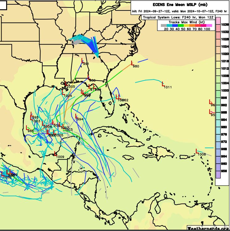
Possible development in the Gulf of Mexico (Is Invest 92L)

This is the general tropical discussion area. Anyone can take their shot at predicting a storms path.

Moderator: S2k Moderators

Forum rules

The posts in this forum are NOT official forecasts and should not be used as such. They are just the opinion of the poster and may or may not be backed by sound meteorological data. They are NOT endorsed by any professional institution or STORM2K. For official information, please refer to products from the National Hurricane Center and National Weather Service.

Help Support Storm2K
Message
Author
User avatar
cycloneye
Admin
Admin
Posts: 145270
Age: 68
Joined: Thu Oct 10, 2002 10:54 am
Location: San Juan, Puerto Rico

Re: Possible development in the Western Caribbean

#61 Postby cycloneye » Fri Sep 27, 2024 12:56 pm

Western Caribbean:
An area of low pressure could form over the western Caribbean Sea by
the middle of next week. Environmental conditions are expected to be
conducive for slow development thereafter while the system moves
generally northwestward, potentially entering the Gulf of Mexico by
the end of next week.
* Formation chance through 48 hours...low...near 0 percent.
* Formation chance through 7 days...low...30 percent.
0 likes   
Visit the Caribbean-Central America Weather Thread where you can find at first post web cams,radars
and observations from Caribbean basin members Click Here

User avatar
HurricaneAndre2008
Category 1
Category 1
Posts: 334
Age: 27
Joined: Wed Jul 31, 2019 9:51 pm
Contact:

Re: Possible development in the Western Caribbean

#62 Postby HurricaneAndre2008 » Fri Sep 27, 2024 1:01 pm

I have a feeling that this will be a big one too.
1 likes   
Cindy(2005), Katrina(2005), Rita(2005), Erin(2007), Isaac(2012)

User avatar
Teban54
Category 5
Category 5
Posts: 3204
Joined: Sat May 19, 2018 1:19 pm

Re: Possible development in the Western Caribbean

#63 Postby Teban54 » Fri Sep 27, 2024 1:03 pm

HurricaneAndre2008 wrote:I have a feeling that this will be a big one too.

So far models haven't been ballistic on intensity for this one (outside of a few GFS runs), but they didn't with Helene at this lead time either. Initially, Helene was expected to be a weak TS/C1 either quickly crossing the Florida peninsula or buried in the BoC, depending on which model you looked at.
4 likes   

Stratton23
Category 5
Category 5
Posts: 2513
Joined: Fri Jul 21, 2023 10:59 pm
Location: Katy, Tx

Re: Possible development in the Western Caribbean

#64 Postby Stratton23 » Fri Sep 27, 2024 1:37 pm

Euro 12z has a weak system approaching the middle texas coast, though not sure if that from the 2nd system or not
0 likes   

Weathertracker96
Tropical Storm
Tropical Storm
Posts: 104
Joined: Mon Oct 16, 2023 3:41 pm

Re: Possible development in the Western Caribbean

#65 Postby Weathertracker96 » Fri Sep 27, 2024 1:48 pm

Teban54 wrote:
HurricaneAndre2008 wrote:I have a feeling that this will be a big one too.

So far models haven't been ballistic on intensity for this one (outside of a few GFS runs), but they didn't with Helene at this lead time either. Initially, Helene was expected to be a weak TS/C1 either quickly crossing the Florida peninsula or buried in the BoC, depending on which model you looked at.


I agree. Climatology suggests more fronts coming and storms tracking more NE so it’ll be interesting to see what this possibly does.
Eric Webb made a tweet about a west pacific system that may affect the pattern which could lift a potential Caribbean system north early to mid October.
2 likes   

User avatar
Kazmit
Category 5
Category 5
Posts: 2124
Age: 22
Joined: Mon Jul 25, 2016 8:49 am
Location: Williamsburg, VA / Bermuda

Re: Possible development in the Western Caribbean

#66 Postby Kazmit » Fri Sep 27, 2024 2:02 pm

Kind of odd that the models are showing this getting so far west. Would think a trough would pick it up sooner at this time of year.
0 likes   
Igor 2010, Sandy 2012, Fay 2014, Gonzalo 2014, Joaquin 2015, Nicole 2016, Humberto 2019

I am only a tropical weather enthusiast. My predictions are not official and may or may not be backed by sound meteorological data. For official information, please refer to the NHC and NWS products.

User avatar
Travorum
Category 1
Category 1
Posts: 406
Joined: Tue Sep 05, 2023 9:36 am
Location: Dunedin, FL

Re: Possible development in the Western Caribbean

#67 Postby Travorum » Fri Sep 27, 2024 2:02 pm

One thing to watch with this system is the tropical wave currently in front of Joyce. It will be passing through the Caribbean at the same time as the CAG is spitting off an area of low pressure and the two may end up merging to form the system. The latitude and timing of the tropical wave seems to be one contributing factor in the run-to-run variability right now, stronger model runs have the wave either pass by early or aid in the consolidation of the CAG low, whereas weaker runs have the wave to the Northeast of the dominant low stretching out the vorticity and preventing development until the Gulf.
6 likes   

jlauderdal
S2K Supporter
S2K Supporter
Posts: 7182
Joined: Wed May 19, 2004 5:46 am
Location: NE Fort Lauderdale
Contact:

Re: Possible development in the Western Caribbean

#68 Postby jlauderdal » Fri Sep 27, 2024 2:37 pm

Travorum wrote:One thing to watch with this system is the tropical wave currently in front of Joyce. It will be passing through the Caribbean at the same time as the CAG is spitting off an area of low pressure and the two may end up merging to form the system. The latitude and timing of the tropical wave seems to be one contributing factor in the run-to-run variability right now, stronger model runs have the wave either pass by early or aid in the consolidation of the CAG low, whereas weaker runs have the wave to the Northeast of the dominant low stretching out the vorticity and preventing development until the Gulf.

MIAMI NWS

LATE NEXT WEEK...
THE LONG RANGE MODELS ARE SHOWING A TROPICAL WAVE MOVING THROUGH
THE CARIBBEAN SEA WITH THE NORTHERN PORTION MOVING THROUGH SOUTH
FLORIDA. THIS WILL ALLOW FOR AN INCREASE IN TROPICAL MOISTURE
OVER THE REGION LEADING TO AND UPTICK AND SHOWER AND THUNDERSTORM
COVERAGE. HOWEVER, THE WIND FLOW WILL REMAIN EASTERLY OVER SOUTH
FLORIDA FOCUSING THE HIGHEST COVERAGE OVER THE INTERIOR AND WEST
COAST METRO AREAS.
0 likes   

User avatar
gatorcane
S2K Supporter
S2K Supporter
Posts: 23691
Age: 47
Joined: Sun Mar 13, 2005 3:54 pm
Location: Boca Raton, FL

Re: Possible development in the Western Caribbean

#69 Postby gatorcane » Fri Sep 27, 2024 2:45 pm

12Z CMC ensembles, classic October track, let’s hope they are wrong:

Image
6 likes   

jlauderdal
S2K Supporter
S2K Supporter
Posts: 7182
Joined: Wed May 19, 2004 5:46 am
Location: NE Fort Lauderdale
Contact:

Re: Possible development in the Western Caribbean

#70 Postby jlauderdal » Fri Sep 27, 2024 3:19 pm

gatorcane wrote:12Z CMC ensembles, classic October track, let’s hope they are wrong:

Image
EPS with a similiar idea, October is Florida's month.
3 likes   

User avatar
Travorum
Category 1
Category 1
Posts: 406
Joined: Tue Sep 05, 2023 9:36 am
Location: Dunedin, FL

Re: Possible development in the Western Caribbean

#71 Postby Travorum » Fri Sep 27, 2024 3:29 pm

gatorcane wrote:12Z CMC ensembles, classic October track, let’s hope they are wrong:

https://i.postimg.cc/PJyYBm9C/gem-ememb-lowlocs-watl-fh96-234.gif


CMC ensembles have another signal around October 10 after this, October is Octobering...
2 likes   

User avatar
Blown Away
S2K Supporter
S2K Supporter
Posts: 10145
Joined: Wed May 26, 2004 6:17 am

Re: RE: Re: Possible development in the Western Caribbean

#72 Postby Blown Away » Fri Sep 27, 2024 4:22 pm

jlauderdal wrote:
gatorcane wrote:12Z CMC ensembles, classic October track, let’s hope they are wrong:

https://i.postimg.cc/PJyYBm9C/gem-ememb-lowlocs-watl-fh96-234.gif
EPS with a similiar idea, October is Florida's month.


Image
12z ECENS
2 likes   
Hurricane Eye Experience: David 79, Irene 99, Frances 04, Jeanne 04, Wilma 05... EYE COMING MY WAY IN 2024…
Hurricane Brush Experience: Andrew 92, Erin 95, Floyd 99, Matthew 16, Irma 17, Ian 22, Nicole 22…

canes92
Tropical Storm
Tropical Storm
Posts: 127
Age: 32
Joined: Tue Mar 06, 2018 1:51 pm

Re: Possible development in the Western Caribbean

#73 Postby canes92 » Fri Sep 27, 2024 5:50 pm

gatorcane wrote:12Z CMC ensembles, classic October track, let’s hope they are wrong:

https://i.postimg.cc/PJyYBm9C/gem-ememb-lowlocs-watl-fh96-234.gif


No!!!!

Yes let's hope that is very wrong. :x
1 likes   

User avatar
SoupBone
Category 5
Category 5
Posts: 3111
Joined: Tue Sep 20, 2005 5:24 pm

Re: Possible development in the Western Caribbean

#74 Postby SoupBone » Fri Sep 27, 2024 6:20 pm

Stratton23 wrote:Euro 12z has a weak system approaching the middle texas coast, though not sure if that from the 2nd system or not


Texas would be incredibly rare, but with this year, I'd believe it.
1 likes   
Personal Forecast Disclaimer:
The posts in this forum are NOT official forecast and should not be used as such. They are just the opinion of the poster and may or may not be backed by sound meteorological data. They are NOT endorsed by any professional institution or storm2k.org. For official information, please refer to the NHC and NWS products.

Frank P
S2K Supporter
S2K Supporter
Posts: 2774
Joined: Fri Aug 29, 2003 10:52 am
Location: Biloxi Beach, Ms
Contact:

Re: Possible development in the Western Caribbean

#75 Postby Frank P » Fri Sep 27, 2024 6:25 pm

The 18z GFS on the AOI in the Caribbean run provides all your necessary entertainment needs for today. It's a two-part series fyi.
Part 1
Image
Part 2
Image
5 likes   

User avatar
cycloneye
Admin
Admin
Posts: 145270
Age: 68
Joined: Thu Oct 10, 2002 10:54 am
Location: San Juan, Puerto Rico

Re: Possible development in the Western Caribbean (0/30)

#76 Postby cycloneye » Fri Sep 27, 2024 6:31 pm

Western Caribbean Sea and Gulf of Mexico:
An area of low pressure could form over the western Caribbean Sea by
the middle of next week. Environmental conditions are expected to
be conducive for slow development thereafter while the system moves
generally northwestward, likely entering the Gulf of Mexico by the
end of next week.
* Formation chance through 48 hours...low...near 0 percent.
* Formation chance through 7 days...low...30 percent.


Image
0 likes   
Visit the Caribbean-Central America Weather Thread where you can find at first post web cams,radars
and observations from Caribbean basin members Click Here


User avatar
Nimbus
Category 5
Category 5
Posts: 5300
Joined: Mon Jul 19, 2004 10:54 am

Re: Possible development in the Western Caribbean (0/30)

#78 Postby Nimbus » Fri Sep 27, 2024 6:50 pm

Hard to even look at these model runs but at least they are forecasting something weak and sheared.
0 likes   

User avatar
NDG
S2K Supporter
S2K Supporter
Posts: 15446
Joined: Sun Jul 09, 2006 10:14 pm
Location: Orlando, FL

Re: Possible development in the Western Caribbean (0/30)

#79 Postby NDG » Fri Sep 27, 2024 7:05 pm

Still no big development from ICON, who many trust the most, so move along :lol:
j/k
1 likes   

jlauderdal
S2K Supporter
S2K Supporter
Posts: 7182
Joined: Wed May 19, 2004 5:46 am
Location: NE Fort Lauderdale
Contact:

Re: Possible development in the Western Caribbean

#80 Postby jlauderdal » Fri Sep 27, 2024 7:15 pm

Frank P wrote:The 18z GFS on the AOI in the Caribbean run provides all your necessary entertainment needs for today. It's a two-part series fyi.
Part 1
https://i.ibb.co/frtSWtZ/1.gif
Part 2
https://i.ibb.co/gz1tTdr/2.gif

wxman57 wont have a day off for awhile with this setup.
0 likes   


Return to “Talkin' Tropics”

Who is online

Users browsing this forum: HurricaneFan, USTropics and 31 guests