Tropical Wave Over the Far Eastern Atlantic: (Is Invest 97L)
Moderator: S2k Moderators
Forum rules

The posts in this forum are NOT official forecasts and should not be used as such. They are just the opinion of the poster and may or may not be backed by sound meteorological data. They are NOT endorsed by any professional institution or STORM2K. For official information, please refer to products from the National Hurricane Center and National Weather Service.
-
tropicwatch

- Category 5

- Posts: 3426
- Age: 62
- Joined: Sat Jun 02, 2007 10:01 am
- Location: The Villages, Florida
- Contact:
Re: Tropical Wave Over West Africa
Pressures are 1008-1011mb in the vicinity of the tropical wave coming off of Africa. Pressures have also come down across the MDR.
0 likes
Tropicwatch
Agnes 72', Eloise 75, Elena 85', Kate 85', Charley 86', Florence 88', Beryl 94', Dean 95', Erin 95', Opal 95', Earl 98', Georges 98', Ivan 2004', Arlene 2005', Dennis 2005', Ida 2009' Debby 2012' Irma 2017' Michael 2018'
Agnes 72', Eloise 75, Elena 85', Kate 85', Charley 86', Florence 88', Beryl 94', Dean 95', Erin 95', Opal 95', Earl 98', Georges 98', Ivan 2004', Arlene 2005', Dennis 2005', Ida 2009' Debby 2012' Irma 2017' Michael 2018'


Re: Tropical Wave Over West Africa
cycloneye wrote:No lemon yet for wave at the 8 AM TWO.
If NHC posts a lemon before it hits the water, then I know we are in trouble.
0 likes
-
cycloneye

- Admin

- Posts: 149461
- Age: 69
- Joined: Thu Oct 10, 2002 10:54 am
- Location: San Juan, Puerto Rico
Re: Tropical Wave Over West Africa
There is a spin with the wave.

1 likes
Visit the Caribbean-Central America Weather Thread where you can find at first post web cams,radars
and observations from Caribbean basin members Click Here
and observations from Caribbean basin members Click Here
-
chris_fit

- Category 5
- Posts: 3261
- Age: 43
- Joined: Wed Sep 10, 2003 11:58 pm
- Location: Tampa Bay Area, FL
Re: Tropical Wave Over West Africa
So much energy and moisture. This will be an interesting one!
1 likes
-
tropicwatch
- Category 5
- Posts: 3426
- Age: 62
- Joined: Sat Jun 02, 2007 10:01 am
- Location: The Villages, Florida
- Contact:
Re: Tropical Wave Over West Africa
Convection is currently waning, probably because of the SAL it is running into.
0 likes
Tropicwatch
Agnes 72', Eloise 75, Elena 85', Kate 85', Charley 86', Florence 88', Beryl 94', Dean 95', Erin 95', Opal 95', Earl 98', Georges 98', Ivan 2004', Arlene 2005', Dennis 2005', Ida 2009' Debby 2012' Irma 2017' Michael 2018'
Agnes 72', Eloise 75, Elena 85', Kate 85', Charley 86', Florence 88', Beryl 94', Dean 95', Erin 95', Opal 95', Earl 98', Georges 98', Ivan 2004', Arlene 2005', Dennis 2005', Ida 2009' Debby 2012' Irma 2017' Michael 2018'
-
AutoPenalti
- Category 5
- Posts: 4091
- Age: 29
- Joined: Mon Aug 17, 2015 4:16 pm
- Location: Ft. Lauderdale, Florida
Re: Tropical Wave Over West Africa
Convection waning is not surprising, it's not expected to develop until late next week. That's when we know if the mid-range models are correct.
1 likes
The posts in this forum are NOT official forecasts and should not be used as such. They are just the opinion of the poster and may or may not be backed by sound meteorological data. They are NOT endorsed by any professional institution or STORM2K. For official information, please refer to products from the NHC and NWS.
Model Runs Cheat Sheet:
GFS (5:30 AM/PM, 11:30 AM/PM)
HWRF, GFDL, UKMET, NAVGEM (6:30-8:00 AM/PM, 12:30-2:00 AM/PM)
ECMWF (1:45 AM/PM)
TCVN is a weighted averaged

Re: Tropical Wave Over West Africa
The longer it takes to develop, the further west it likely gets, just saying!
2 likes
Re: Tropical Wave Over West Africa
Cpv17 wrote:The longer it takes to develop, the further west it likely gets, just saying!
I agree, going to be a long next 7 days of model watching as it’ll take that long to materialize
3 likes
-
cycloneye
- Admin
- Posts: 149461
- Age: 69
- Joined: Thu Oct 10, 2002 10:54 am
- Location: San Juan, Puerto Rico
Re: Tropical Wave Over West Africa
4 likes
Visit the Caribbean-Central America Weather Thread where you can find at first post web cams,radars
and observations from Caribbean basin members Click Here
and observations from Caribbean basin members Click Here
Re: Tropical Wave Over West Africa
Large surge of water vapor across the Sahara into the Med.
Driven in large part by the low NW of the Canary's
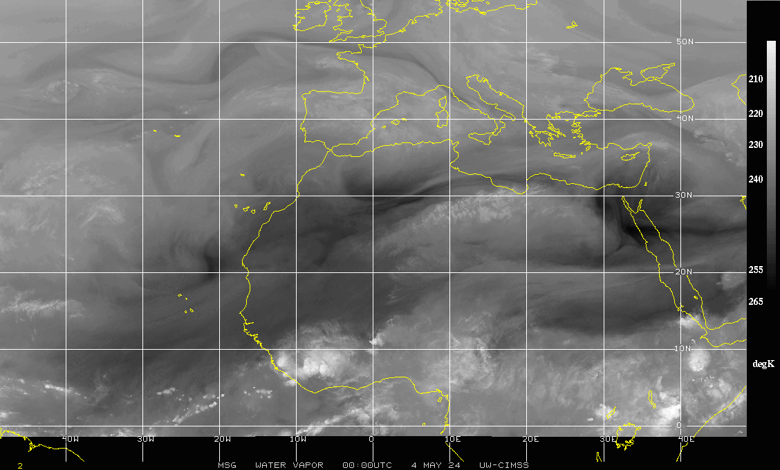
Driven in large part by the low NW of the Canary's
0 likes
-
IsabelaWeather
- Category 1

- Posts: 316
- Age: 36
- Joined: Tue Jul 07, 2020 7:29 am
- Location: Isabela, Puerto Rico
Re: Tropical Wave Over West Africa
tropicwatch wrote:Convection is currently waning, probably because of the SAL it is running into.
Convection almost always pulses down upon splashdown. Im sure youve been here long enough to watch this happen to almost every wave.
2 likes
-
lsuhurricane
- Category 1
- Posts: 270
- Joined: Tue Aug 15, 2017 2:53 pm
Re: Tropical Wave Over West Africa
12z ICON indicates both a further west and weaker solution than its 0z run. East Coast ridge filling in with the coastal low deteriorating. All about timing!
0 likes

Re: Tropical Wave Over West Africa
One thing is certain. It's time to start paying attention ion. I usually stay prepared with food anyway, but need to review everything else.
0 likes
Alicia, Rita, Ike, Harvey and Beryl...moved to Splendora lol
Re: Tropical Wave Over West Africa
12z gfs is trying to develop it this on the (10th) Sunday/Monday a little early and getting over the Cabo Verde. (TS on Tuesday) Not sure it'll get there, but that's a very notable difference from the prior few runs. New lemon at 2 based on this alone probably.
TS on Tuesday:

TS on Tuesday:
Last edited by BobHarlem on Fri Aug 08, 2025 11:07 am, edited 3 times in total.
0 likes
-
TampaWxLurker
- Tropical Storm

- Posts: 196
- Joined: Thu Aug 01, 2024 8:20 am
Re: Tropical Wave Over West Africa
GFS takes it on a beeline WNW over the CV islands through 96 hours.
0 likes
-
lsuhurricane
- Category 1
- Posts: 270
- Joined: Tue Aug 15, 2017 2:53 pm
Re: Tropical Wave Over West Africa
One thing is certain on this GFS run, no lingering low-pressure systems to its north. Ridging is fairly dominant.
0 likes
Re: Tropical Wave Over West Africa
The 12Z UKMET is likely the 1st with a TD from this as it forms in only 114 hours (thus lemon-worthy). After sliding just N of the N Leewards, it ends the run approaching TS strength (33 knts/38 mph winds) 430 miles ENE of PR moving WNW at a pretty brisk 18 mph. Will have to wait for maps to get better idea of whether or not its implying it would likely recurve offshore the Conus
NEW TROPICAL CYCLONE FORECAST TO DEVELOP AFTER 114 HOURS
FORECAST POSITION AT T+114 : 15.8N 46.0W
LEAD CENTRAL MAXIMUM WIND
VERIFYING TIME TIME POSITION PRESSURE (MB) SPEED (KNOTS)
-------------- ---- -------- ------------- -------------
1200UTC 13.08.2025 120 16.1N 48.2W 1009 28
0000UTC 14.08.2025 132 17.8N 51.6W 1009 27
1200UTC 14.08.2025 144 18.9N 54.9W 1009 29
0000UTC 15.08.2025 156 20.3N 57.7W 1009 30
1200UTC 15.08.2025 168 21.4N 60.9W 1007 33
Last edited by LarryWx on Fri Aug 08, 2025 11:22 am, edited 3 times in total.
0 likes
Personal Forecast Disclaimer:
The posts in this forum are NOT official forecasts and should not be used as such. They are just the opinion of the poster and may or may not be backed by sound meteorological data. They are NOT endorsed by any professional institution or storm2k.org. For official information, please refer to the NHC and NWS products.
The posts in this forum are NOT official forecasts and should not be used as such. They are just the opinion of the poster and may or may not be backed by sound meteorological data. They are NOT endorsed by any professional institution or storm2k.org. For official information, please refer to the NHC and NWS products.
-
Ian2401
- Category 1
- Posts: 321
- Joined: Thu Sep 14, 2017 5:55 pm
- Location: Tallahassee, Florida
- Contact:
Re: Tropical Wave Over West Africa
Watching the GFS run come in. Significantly stronger in the near-short term. Anxiously awaiting to see how much it blows once it gets west. One benefit of a stronger storm earlier is that it will naturally get tugged more north via beta drift. Ridging still looks strong, so it's going to get west - question is how far and will there be an escape route? It is already at 20N at the last frame I can see, so generally it will be difficult to get all the way to the CONUS without really anomalously strong ridging. Track almost looks similar to Irma, except Irma famously had insanely strong high pressure build in to its north that actually shoved the storm SW, losing about 2.5deg of latitude in the process.
1 likes
B.S. Meteorology from Florida State '24 // Current M.S. Meteorology student at Florida State
Research Interests: Rapid Intensification, TC Climatology, TC Modeling
Consult the NHC for official information
Research Interests: Rapid Intensification, TC Climatology, TC Modeling
Consult the NHC for official information
Re: Tropical Wave Over West Africa
Ian2401 wrote:Watching the GFS run come in. Significantly stronger in the near-short term. Anxiously awaiting to see how much it blows once it gets west. One benefit of a stronger storm earlier is that it will naturally get tugged more north via beta drift. Ridging still looks strong, so it's going to get west - question is how far and will there be an escape route? It is already at 20N at the last frame I can see, so generally it will be difficult to get all the way to the CONUS without really anomalously strong ridging. Track almost looks similar to Irma, except Irma famously had insanely strong high pressure build in to its north that actually shoved the storm SW, losing about 2.5deg of latitude in the process.
I remember in one of my college classes I think during 2018 or 2019, I mentioned how thankful I was that Irma spent so long hugging the coastline of Cuba, because that prevented Irma from being a strong cat five at landfall in Florida rather than a weakening cat four. That caused one of my classmates to basically say don’t you care about the people in Cuba, and all I could say was I guess but I care about us more.
1 likes
-
StPeteMike

- Category 2

- Posts: 655
- Joined: Thu Jun 07, 2018 11:26 pm
Re: Tropical Wave Over West Africa
Not buying the quick in development that the GFS is indicating. There’s a lot of Saharan Dust out ahead of it that will likely impede such development early on. Development likely won’t come together until it gets to 50W, imo.
1 likes
The above post is not official and should not be used as such. It is the opinion of the poster and may or may not be backed by sound meteorological data. It is not endorsed by any professional institution or storm2k.org. For official information, please refer to the NHC and NWS products.
Who is online
Users browsing this forum: Google [Bot], hurricanes1234, ljmac75 and 59 guests