AccuWeather Hurricane Threat

This is the general tropical discussion area. Anyone can take their shot at predicting a storms path.

Moderator: S2k Moderators

Forum rules

The posts in this forum are NOT official forecasts and should not be used as such. They are just the opinion of the poster and may or may not be backed by sound meteorological data. They are NOT endorsed by any professional institution or STORM2K. For official information, please refer to products from the National Hurricane Center and National Weather Service.

Help Support Storm2K
Message
Author
User avatar
SupertyphoonTip
Tropical Depression
Tropical Depression
Posts: 77
Joined: Sat May 29, 2004 12:50 am
Location: Cape Cod, Massachusetts

#61 Postby SupertyphoonTip » Sun Jul 04, 2004 10:53 am

Stormsfury wrote:The NHC's official track 72 hours from landfall actually was pretty much spot on and verified much, much closer to reality, while Accuweather's forecast placed Gilbert into the Houston-Galveston region. In fact, the "only" major success I can recall Accuweather having was in regards to Floyd in 1999, with the sharp recuravture to the NNE into North Carolina. (Someone there musta followed the ECMWF's track which turned out to be the best bet ... BTW, the ECMWF showed this SEVEN days out).

Otherwise, I've noticed that Accuweather's tracks seem to have a sharper recurvature bias.

SF


Well they forecasted Isidore's turn into the Yucatan in 2002, a storm like Bill of last year was talked about in May, and Bastardi correctly forecasted Claudette's intensity at landfall in Texas (85-95 MPH), while it was a strongly sheared 45-knot tropical storm in the southern GOM.
0 likes   

MWatkins
S2K Supporter
S2K Supporter
Posts: 2574
Joined: Sat Oct 12, 2002 7:51 pm
Location: SE Florida
Contact:

#62 Postby MWatkins » Sun Jul 04, 2004 10:58 am

Just remember this dudes: NOTHING either of you put out this year remotely resembles Joe's landfall intensity forecast. So you can sit back and comment all you want. Despite your prestige and accumen, you're only peanut gallery until you hang yourself out for riddicule or success. Like it or not, that's REALITY baby.


I probably won't do a landfall forecast in my lifetime. I admire JB and Jason Moreland and his team for taking these forecasts on...but overall I don't think the return in time is worth the investment in results. However...I do put out each and every forecast I make through a microcope for all to see (not sure how many actually see it).

http://www.tropicalupdate.com/2003%20Fo ... cation.htm

I did take a slight sideswipe at JB for making his forecasts easy to spin...but I think we have all been guilty of that from time to time.

I have included a post from a couple of months ago at the bottom (in reply to Jason's forecast). I have no better way of explaining my whole stance on the landfall forecast thing.

The concept that certain patterns allow for greater or less overall US landfalls is not new and I'm OK with that. But please follow my logic here:

1. The 120 hour error rate...one way or the other...with a system in the Atlantic...is roughly 300 nautical miles (5 degrees of latitude/longitude). And that's given two huge pieces of important information...system strength and system LOCATION.

2. Tropical cyclones are not large-scale events. They are highly susceptible to small...difficult to resolve features that cannot be predicted months in advance no-way no-how. For example, no one here, at the TPC, CSU or anywhere else can tell me that a hurricane will not, any given time:

a. Pass over a cold wake from another system
b. Not get embedded in a SAL
c. Happen to develop at the base of a receding 500MB trough and sneak past a persistent central Atlantic trough...then move west for several days
d. Not encounter a cutoff ULL
e. Avoid the Dominican Republic
f. Traverse Puerto Rico lengthwise from east to west

Florida, for example, has been EXTREMELY lucky in this regard. Floyd caught an approaching trough at the last possible second. David got tangled with the DR. Georges would have undoubtedly been a Cat 3 at least had it not gone directly over Puerto Rico. Things could have definitely been different with Debbie had it not passed so close to the DR. I don't write this because I live in Florida...it just happens to be true. Florida...in general...has been lucky.

A few small bad breaks, and all of this climatology stuff goes out the window. Or maybe reverses. Who knows, but I don't think anyone here can realistically suggest that a westerly QBO, or La nina, the PDO or NAO or the FBI or the KGB or MTV *caused* Puerto Rico to get in the way of Georges or any of this other stuff...'cause it's not ture.

To extend on that...if anyone said that of the 100 waves that will cross the Atlantic this year...waves 16,22,67,89,90, and 92 will develop where the others won't...would be completely CERTIFIABLE and probably get themselves banned from this board.

Back to my main point. Lets say this season we have a system approaching the Turks and Caicos islands. Even if we knew how strong it was...which direction it was moving...and all of the dynamic model output etc...300 nautical miles...our expected forecast error...could be the difference between a system cutting between the Bahamas and FL...or smashing into Apalachicola.

I just am not buying Gray's numbers. I'm OK with frequency and general trends...but I don't but into determining with our current technology who will get hit and who won't three months from now. We can't even determine how strong a system will be with any reasonable certainty 48 hours from forecast time.

And...considering we know next to nothing about intensity forecasting...saying that location X is more likely to get a weak TS versus location Y, who will get a hurricane...is scientific conjecture AT BEST, with no real application to the real world, and Ms Cleo Astrology at worst. There is no way...even if successful this data could be applied due to the law of large numbers. Had we read something about how 1992 was going to be a Nino year...and this board were around in 1992...folks around Aug 2nd would have proclaimed the season dead.

So..in conclusion...I like the work...I like the risk...and I like the presentation. Do not let my rant discourage you from continuing (not that you will...I'm sure you won't). I don't think your opinions are wrong...they are conclusions and opinions...and we all draw different ones. My opinion is that we don't know enough about small scale events to draw inferences on landfall probablilties in a paticular year. But I have been wrong before.


MW
0 likes   

User avatar
Steve
S2K Supporter
S2K Supporter
Posts: 9628
Joined: Sat Apr 05, 2003 11:41 pm
Location: Gulf of Gavin Newsom

#63 Postby Steve » Sun Jul 04, 2004 12:24 pm

FWIW MW, the part you quoted didn't apply to you. It was more toward Derek O and Dericho (ref. "either of you"). I respect both of those guys but they continually display an anti-Bastardi agenda. In Ortt's case, he doesn't like the way Accuweather runs their business side of things and the way they rip off new graduate mets. Fine and dandy. But the University of Miami or RMSAS isn't putting anything out at the level Joe's doing so they really should reserve comment until they can offer something similar or better. I got into it with Ortt last year over the NHC's seasonal prediction which was useless to me. He said it was important to him. It was a big whatever and the typical safe-bet stuff from the government. So the question remains between the competitors: who's research is yielding what?

As for Dericho, he thinks he's all that and is quick to criticize. Problem is the same as with the U of M peeps. He doesn't put anything out there on his own. It's easy to take potshots from an insulated sniper position if you will. He gets irritated because I can see through his b.s. I think they guy's really smart and knowledgable but because he can't control himself, he just comes off like a tool. Ask anyone.

As for you, I don't have any problems with ya' and never have. I read all your posts. I just disagreed wtih one point you had made which was that even if the landfall intensity forecast verifies 100%, it doesn't say anything. I disagree with that. I don't expect perfection in this arena whatsoever. But if time continues to show a degree of forecasting skill, then it falls outside of the realm of something we'd want to dismiss. That's all. What the detractors fail to realize is that at least he's putting something out there for consumption. No one has to take his spin on it. They can put their own on it. But for someone to, in essence, stake his or her reputation on what they put out, that at least shows a set of balls on his part. Maybe after the season's over, we can re-visit this whole idea. I won't feel like I'm breaking the TOS with Accuweather Pro if I put out the predicted numbers in hindsight, and then we look at what happened during the season. That will bear out a lot more than some insecure moron saying "Bust-Turdi" when said insecure moron can't acquit for himself.

Peace out and happy 4th of July to everyone. GBA

Steve
0 likes   

Anonymous

#64 Postby Anonymous » Sun Jul 04, 2004 12:49 pm

Oh yes the government reminds me of something:

I'd rather listen to JB's long ranger all day rather than resorting to government. NOAA's weather radio is one of the most boring of all time. A complete broken record with some foreign voice very hard to understand half the time. It's basically only useful during a power outage or in your car. Plus with the goverment's warm bias problems in winter, I have absolutely no use for the weather service's winter outlooks at all, or 7 day forecast for that much. It seems to me they need to make a more careful analysis of the rapid changes you can expect from day to day in the extended range, rather than just grapling the same old song of average climatology. Even last winter I remember them saying "highs in the upper 50's, and 4 days later when we got there, it was 35 and raining ! That's totally unacceptable ! I wouldn't even waste my time with them, unless there is a super storm approaching where the 24 to 48 hour discussion and specific forecasts are more important. And even then, I have to shut off the weather radio within 10 minutes ! :D

Ken
0 likes   

ColdFront77

#65 Postby ColdFront77 » Sun Jul 04, 2004 1:14 pm

NOAA Weather Radio, the voice of the National Weather Service is needed for us to heed if not us as weather enthusiast
know where severe weather is occurring.

I like the computerized voice, it's actually even better when they "mispronounce" words. :wink:

What else should they broadcast, other than live coverage (even then) in order to not have a "broken record"?
0 likes   

Anonymous

#66 Postby Anonymous » Sun Jul 04, 2004 1:25 pm

Fine but I can get all that info (including live radar) on line much faster than waiting 8 minutes until they broadcast a special weather statement or warning for that much. Plus Pro AccuWeather, including other models, make a much more detailed (and interesting) forecast scenario over a 7 day period than the weather service's same old song. :wink:
0 likes   

Derek Ortt

#67 Postby Derek Ortt » Sun Jul 04, 2004 2:38 pm

Scientifically, that forecast has NO merit as it is not quantifiable. Reality is, quantifiable statistics are how things are verified, not based upon rambling details or for time periods

UM does not issue forecasts as #1, NOAA already makes the forecast, and #2, the science is not there to be precisely quantifiable at the present time and for that to be accurate
0 likes   

Anonymous

#68 Postby Anonymous » Sun Jul 04, 2004 2:58 pm

Many of the details they mention have verified very well in their two week outlook, already based on GFS,Canadian ensembles and other models. They just modify some of the outlooks with additional input from their own qualified perspective - and many many times have won over the NWS official forecasts. Not saying this is "always" the case but often that has been the case. They make the forecasts much more interesting to look at even though they are not perfect. Last spring they had a special representation concerning NOAA's standard deviation charts, which showed that sometimes they can be agenda driven in their previous statistics when it comes to temperature charts - such as last spring 2003 (not sure what the month was anymore) . Areas which actually had temps from 1 to 4 degrees BELOW average up north were painted in the "above normal" category. That is not accurate and not quantifiable to me. When it gets to hurricane predictions, that is a more complicated problem because meteorology is not an exact science.

Appreciate your input,

Ken
0 likes   

donsutherland1
S2K Analyst
S2K Analyst
Posts: 2718
Joined: Mon Sep 15, 2003 8:49 pm
Location: New York

Re: AccuWeather Hurricane Threat

#69 Postby donsutherland1 » Sun Jul 04, 2004 7:48 pm

Having finished a holiday barbecue and glanced at the hurricane forum, I noticed that there appears to be perhaps some misunderstanding concerning Joe Bastardi’s (JB’s) seasonal hurricane/tropical storm forecast.

The first issue concerns value. Do such forecasts offer value?

I believe they do, especially as they improve with time and experience gleaned from making and verifying such forecasts. In the past, hurricane forecasting merely focused on each storm at hand. Such forecasts are vitally important and skills from the NHC and others have improved markedly. Later, Dr. William Gray began to forecast the amount of hurricane activity one could reasonably expect each season and demonstrated genuine skill in doing so. Now, JB and some others have moved to the proverbial next frontier and are attempting to hone in areas likely to be affected from the upcoming season’s hurricane activity. If accurate, there is probably little question that such forecasts can become an invaluable tool for emergency planners, risk planners, etc. To date, from what I have seen, JB has demonstrated skill with his forecasts.

The second issue concerns verifiability. Are such forecasts verified?

At the end of each season, JB attempts to analyze how well or poorly his forecast fared, what went right or wrong, etc. Moreover, for those who read his hurricane forecasts in their entirety, JB provides a transparent methodology by which he verifies such forecasts. Furthermore, to his credit he attempts to demonstrate how well or poorly he did and is not afraid to give himself low marks when the occasion calls for it e.g., he gave himself an “F” for his June 2004 forecast for Texas. Is JB’s methodology the best one by which to evaluate such forecasts? That’s a different issue. Perhaps, others have additional ideas. However, at this point, there really is no single universal criteria by which such forecasts are evaluated.

The third question that arose—and on the face of things, it’s a good one—concerns whether it is realistic for JB’s top designated landfall area to be adjacent to a below-average landfall area.

Actually, if one examines past climate records, such situations across-the-board (i.e., temperatures, precipitation, snowfall, etc.) are not unprecedented. For example, during Winter 2003-04, New York City received much above normal snowfall (more than 40”). Philadelphia and Boston, on the other hand, received below normal snowfall. The same kind of situation likely can apply to areas impacted by hurricanes/tropical storms based on their track.

A fourth question concerns what is foreseeable.

While some matters are not foreseeable, it should be emphasized that the field has such talent available that just because one or a number of forecasters might not see something, it does not necessarily mean that others won’t or even that such a situation was not foreseeable. Thus, when one makes the statement that something was not foreseeable, one might well be treading on extremely treacherous ground.

Indeed, using the example of 1995 that arose in the thread, the 1995 Atlantic Ocean SSTAs (especially during the July 1-September 30 period) hinted at the kind of Azores High that predominated. Moreover, if one were to compare, let’s say the 1995 SSTAs with the 2003 SSTAs using the CDC’s reanalysis data and also take a look at the hurricane/tropical storm tracks those two seasons (from TPC’s best track reanalysis), one finds that in both cases the SSTAs provided insight into what actually took place.

Is the use of SSTAs foolproof? No. But, given the phenomenon of atmospheric forcing, SSTAs can be a useful tool, among others, in providing guidance for the development of seasonal forecasts.

In the end, this is my understanding of JB's seasonal forecasts and also recollections of certain events (which I verified by looking back at the reanalysis data). Perhaps, it might help clear up some of the questions and concerns. Perhaps it might just create more confusion, especially if one had a fair bit to drink at one of today's many festivities.

Finally, I do believe JB responds to well-reasoned e-mail. So, if one wants to ask for more details into his methodology—e.g., why he chose to verify the forecasts as he does, etc.—then I believe he might well respond.

To all, a happy holiday!
0 likes   

Rainband

#70 Postby Rainband » Sun Jul 04, 2004 8:39 pm

Excellent post donsutherland1 :D
0 likes   

User avatar
vbhoutex
Storm2k Executive
Storm2k Executive
Posts: 29133
Age: 74
Joined: Wed Oct 09, 2002 11:31 pm
Location: Cypress, TX
Contact:

#71 Postby vbhoutex » Sun Jul 04, 2004 10:16 pm

Thank you Don for another well reasoned posting. And I can verify that JB does indeed respond to well reasoned emails.
0 likes   
Skywarn, C.E.R.T.
Please click below to donate to STORM2K to help with the expenses of keeping the site going:
Image

User avatar
Lindaloo
Category 5
Category 5
Posts: 22658
Joined: Sat Mar 29, 2003 10:06 am
Location: Pascagoula, MS

#72 Postby Lindaloo » Sun Jul 04, 2004 10:25 pm

Exellent post Don!! :D
0 likes   

MWatkins
S2K Supporter
S2K Supporter
Posts: 2574
Joined: Sat Oct 12, 2002 7:51 pm
Location: SE Florida
Contact:

#73 Postby MWatkins » Sun Jul 04, 2004 10:38 pm

Ah yes. We have finally stirred up a pretty good back and forth here. I just got back...no drinks...and found a couple of really good posts. I'll do my best to respond with my POV...

First...I'll try to crystalize my thoughs in the context of Mr southerlands well crafted post.

The first issue concerns value. Do such forecasts offer value?


I think that depends on who you ask. Is it fruitless? No...I believe that over time computer modeling and additional climatological data through technologies suck as QuikScat will make the science more accurate.

However...NOAA flipped out when landfall percentages were put up on Gray's experimental site. It will cause confusion and complacency...they say. Riiigght. This is just another attempt to hang on to their one voice approach now that the technology...once available only to them...is readily avaiable to everyone (well...almost all of it).

I believe forging ahead is also worthwhile...there will be good years and bad years...but I think it will be 15-20 years with the current technology to get a good read on the results as they are verified.

Here's a good example. Let's say that this year's forecast calls for a 30% chance of a landfall in SW florida. We need 10 analog years with conditions very close to this year to determine skill. Hindcasting takes care of some of this...but there are not enough reliable years in the dataset. In fact...we really only have a little more than 40 years in our dataset since satellites were used.

The second issue concerns verifiability. Are such forecasts verified?


They are...but my main point is how are they verified? Good results are one thing...but the baseline for this and any forecast like this has to be climatology...otherwise there is no context for evaluation. I believe JB would benefit from coming up with a scheme to verify these foreasts vs. climatology. There has to be a way to determine relative skill. I'm going to think about that and see if there is a way to do it. Climo can be universal...and absolute.

The third question that arose—and on the face of things, it’s a good one—concerns whether it is realistic for JB’s top designated landfall area to be adjacent to a below-average landfall area.


I'm going to have to concede that this does happen all the time. My hometown in Kansas always got about half the snowfall that Wichita got even though the cities were an hour away from each other. But I still don't believe we have the ability to give SW Fl a 1 and SE Fl a 7 on a 10 point scale...another Cleo could come right up the middle and verify and bust the same forecast.

A fourth question concerns what is foreseeable.


My bone of contention is that although some things...such as low pressures in the ITCZ or a stronger than average Azores high can be forseen...small butterflies in the Matrix make nailing down landfalls along the US coast difficult.

Again, great post donsoutherland.

Steve...I feel my previous reply was incomplete:

I read all your posts. I just disagreed wtih one point you had made which was that even if the landfall intensity forecast verifies 100%, it doesn't say anything. I disagree with that.


I agree with your disagreement. I left out a critical piece of that sentance that I though of but had to reread before I noticed I left it out:

(in a single year).

I don't think one year is significant. It is something to build on...and a suggestion that the forecaster is on the right track. But more data needed.

Perhaps hindcasting could help here too...and maybe JB has done that.

I never though you had any problem with me...I just didn't know if you knew that I verify my stuff the best I can...

Thanks to you and everyone else for adding to the discussion...I've enjoyed this one.

MW
0 likes   

User avatar
Stormsfury
Category 5
Category 5
Posts: 10549
Age: 53
Joined: Wed Feb 05, 2003 6:27 pm
Location: Summerville, SC

#74 Postby Stormsfury » Sun Jul 04, 2004 11:45 pm

SupertyphoonTip wrote:
Stormsfury wrote:The NHC's official track 72 hours from landfall actually was pretty much spot on and verified much, much closer to reality, while Accuweather's forecast placed Gilbert into the Houston-Galveston region. In fact, the "only" major success I can recall Accuweather having was in regards to Floyd in 1999, with the sharp recuravture to the NNE into North Carolina. (Someone there musta followed the ECMWF's track which turned out to be the best bet ... BTW, the ECMWF showed this SEVEN days out).

Otherwise, I've noticed that Accuweather's tracks seem to have a sharper recurvature bias.

SF


Well they forecasted Isidore's turn into the Yucatan in 2002, a storm like Bill of last year was talked about in May, and Bastardi correctly forecasted Claudette's intensity at landfall in Texas (85-95 MPH), while it was a strongly sheared 45-knot tropical storm in the southern GOM.


I'm not saying that Accuweather doesn't have its share of successes, but they have had some failures as well ... look at Henri last year ... does anybody remember the sensationalism last year regarding that from Accuweather? How about Larry? My goodness, what a frenzy that Mexican bound storm caused ... particularly on many messageboards.

The biggest problem I have with Accuweather is the sensationalist style that is brought across ... although, I've seen MANY people also take things way out of context as well, only using bits and pieces and doing their own interpretation of things, ESPECIALLY when JB outlines many possible scenarios and someone grabs ONLY the one scenario which brings something MAJOR IMBY.

It would be nice NOT to see the all out ranting and raving about not enough RECON flights in Claudette last year.

It would be nice NOT to tell people that Atlanta was going to see the 0º line into their backyards some 7-10 days out based on a computer model (*cough* - GFS) with a pronounced and known cold bias.

That's what bother me the most ...

Again, I'm NOT saying that Accuweather doesn't have good mets, but the sensationalist styles for ratings, whatever just doesn't suit me. IF something big is on the horizon, outline the potentials (like I try to do in my prognostic MR discussions).

Just my 2 cents.
0 likes   

LarryWx
S2K Supporter
S2K Supporter
Posts: 6853
Joined: Sun Sep 07, 2003 2:04 pm
Location: GA

#75 Postby LarryWx » Mon Jul 05, 2004 9:51 am

wxman57 wrote:
Jekyhe32210 wrote:Apparently, they are going by landfalls... A cane moving across fla from gulf to atlantic would not cause near the damage as a cane hitting the ECoast directly--lil/no storm surge cuz its coming from land--mobile home residents and flood prone persons would need to leave however.


Yes, only the landfall side of the state is considered. Where a storm might exit Florida is not considered a landfall point, even though it may be a Cat 5 all the way across Florida. Landfall can only occur on one coast. Of course, that doesn't mean that NE Florida isn't at risk for some nasty weather when storms move in from the southwest.


You are not correct in how you interpret JB's scoring. Unless JB decides to suddenly score them differently for 2004, he is definitely NOT just considering landfalls. In other words, if there somehow were a cat 5 maintaining itself all of the way across the Florida peninsula, it would count as a cat 5 for the east coast of Florida also. For 2003's Bill, which made landfall in LA, moved NEward up into the Appalachians, and then weakened, he gave points (albeit very small) to portions of the east coast. Had he gone only with the landfall, there's no way he could have given any points for any of the east coast.

I could also cite some other storms, but figured that Bill, alone, is enough proof to illustrate my point.
Last edited by LarryWx on Tue Jul 06, 2004 11:28 am, edited 1 time in total.
0 likes   
Personal Forecast Disclaimer:
The posts in this forum are NOT official forecasts and should not be used as such. They are just the opinion of the poster and may or may not be backed by sound meteorological data. They are NOT endorsed by any professional institution or storm2k.org. For official information, please refer to the NHC and NWS products.

michaelwmoss
Category 2
Category 2
Posts: 558
Joined: Thu Mar 25, 2004 1:56 am
Location: New Whiteland, IN
Contact:

#76 Postby michaelwmoss » Mon Jul 05, 2004 11:07 am

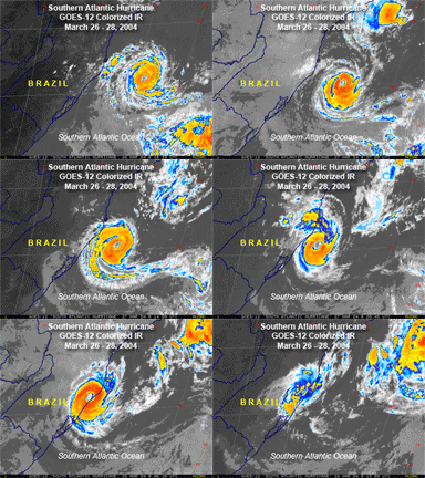
Super Typhoon Tip:

That is an awesome picture of that South America Hurricane. Where did you get it at?

Definately looks like a Southern Hemisphere Tropical System. The CDO looked very well defined right before landfall as well as the eye. Seeing a tropical system spin Clockwise is always a hoot:)
0 likes   

donsutherland1
S2K Analyst
S2K Analyst
Posts: 2718
Joined: Mon Sep 15, 2003 8:49 pm
Location: New York

#77 Postby donsutherland1 » Mon Jul 05, 2004 2:39 pm

MW,

I fully agree that technological innovation and advances in knowledge will make forecasting--tropical systems, winter storms, etc.--all more accurate.

I believe that sometimes new ideas do generate controversy even if it is just because they are novel. Dr. Gray's landfall percentages are another illustration of what can happen.

Personally, I believe many in the public are sufficiently knowledgeable to understand the landfall percentages and that they should not generate the kind of confusion or complacency some might be concerned about.

I also strongly agree about the number of years required to really get a statistically sound assessment of such forecasts.

I understand your point of scoring forecasts against climatology. It will be interesting to see what you come up with. Certainly, there's ample room to develop or improve scoring systems and, if such systems are effective, they can be valuable tools that can help improve forecasts over the medium- and longer-term.
0 likes   

michaelwmoss
Category 2
Category 2
Posts: 558
Joined: Thu Mar 25, 2004 1:56 am
Location: New Whiteland, IN
Contact:

#78 Postby michaelwmoss » Mon Jul 05, 2004 3:41 pm

Don Sutherland:

Interesting response, not one I was expecting :)

I don't think Climatology can fully be trusted in Hurricane Forecasting. It's based on averages of the past and you simply can't outsmart Mother Nature (Or God I should say :)

Take Indiana's Severe Weather: We have been seeing an increase in Tornado Frequency over time. In fact, this year alone we have seen more Torando Watches (Almost As Many Warnings Too) Than Severe Thunderstorm. In two years time we have seen Several Larger Tornadoes hitting the area as well, Particuarly Indianapolis. One could point to climatology and say that our climate is warming up, but at the same time our temps for the most part have been at or Below Normal. I think it has more to do with The Desert and Gulf Of Mexico either expanding their size or area of influence.

If you also look at the Tornado Alley Map, it has expanded East over time as well.


So it may have to do a bit with Climatology, but I do believe you also have to look at other factors
0 likes   

donsutherland1
S2K Analyst
S2K Analyst
Posts: 2718
Joined: Mon Sep 15, 2003 8:49 pm
Location: New York

#79 Postby donsutherland1 » Mon Jul 05, 2004 4:39 pm

Michael,

I didn't intend to suggest that climatology is the only factor behind seasonal forecasting be it hurricanes or winter storms. Rather, I meant to suggest that a comparison of forecasts vs. climatology could be useful. If forecasts do better than what climatology would lead one to expect, then the forecasts are adding value. If not, then a straight look at climatology would be better than such forecasts.

Clearly, there are many variables involved. The narrow issue at hand concerned the measurement of how well or poorly given forecasts fare over time and a comparison against climatology is one but not the only means at evaluating such forecasts.

For example, let's say a stock market analyst were to argue that he has a great record in recommending stocks. He then argues over a ten-year span that his picks have generated an average return of 8%. Yet, let's say during that time the broad market e.g., S&P500 Index rose an average of 10% per year. Suddenly, the stock market analyst's track record doesn't look so good, as he underperformed the stock market as a whole.

I'm just reaffirming an earlier point made by MW that judging forecasts against climatology could be a good approach for measuring forecasts. Many factors aside from climatology are involved in making such forecasts.

Here's an example of what I have in mind. I'll use New York City's seasonal snowfall as an example. The seasonal norm comes to roughly 22".

Let's take 3 hypothetical winters (the comparison would need to cover a longer period, but this is just an example to illustrate what I have in mind):

Forecaster X made the following forecasts:

Winter 1: 27"
Winter 2: 18"
Winter 3: 21"

Actual snowfall came to:

Winter 1: 30"
Winter 2: 14"
Winter 3: 23"

The average errors were as follows:

Climatology: 5.7" (8"+8"+1")/3
Forecaster X: 3.0" (3"+4"+2")/3

In this case, Forecaster X did better than climatology. Had Forecaster X had an average error of more than 5.7", Climatology would have been a better guide during this timeframe.
0 likes   

michaelwmoss
Category 2
Category 2
Posts: 558
Joined: Thu Mar 25, 2004 1:56 am
Location: New Whiteland, IN
Contact:

#80 Postby michaelwmoss » Tue Jul 06, 2004 2:00 am

Understandable. You have done your research here. Thank you for the clarification. I'm sure there will be many more ways in the future of predicting storms. Wasn't that long ago we didn't even have Nexrad :)

Side Note: If you like listening to "stuff" on the net, I was able to record a thunder clip from a Severe Storm West of New Whiteland About an hour ago. You can find the clip at:

http://indiegospelradio.blogspot.com/

Just an example of what you can do with Technology these days :) Getting some clips of a severe storm overhead would be really cool!!
0 likes   


Return to “Talkin' Tropics”

Who is online

Users browsing this forum: No registered users and 99 guests