African wave IS a player - 93L Invest

This is the general tropical discussion area. Anyone can take their shot at predicting a storms path.

Moderator: S2k Moderators

Forum rules

The posts in this forum are NOT official forecasts and should not be used as such. They are just the opinion of the poster and may or may not be backed by sound meteorological data. They are NOT endorsed by any professional institution or STORM2K. For official information, please refer to products from the National Hurricane Center and National Weather Service.

Help Support Storm2K
Message
Author
philnyc
S2K Supporter
S2K Supporter
Posts: 313
Joined: Thu Jun 07, 2007 1:14 am
Location: Brooklyn, New York City, New York
Contact:

BigA's question

#61 Postby philnyc » Sat Jun 09, 2007 5:13 pm

BigA wrote:Perhaps, though I find it unlikely, this wave can redevelop some convection in the upcoming days. The water is conceivably warm enough, given the low latitude of the wave. I wonder, though, whether the two waves in june that became short lived tropical depressions (in 2000 and 2003) died off their convection upon hitting the water, and reformed it later, or whether their convective structure remained relatively intact.


Here's a link to the NHC history of TD02 in 2003:
http://www.nhc.noaa.gov/2003two.shtml?
The recaps on most of them are pretty thorough, as you can see from that one.

You can get a lot of great info in this archive. Here's the general link:
http://www.nhc.noaa.gov/pastall.shtml
0 likes   

philnyc
S2K Supporter
S2K Supporter
Posts: 313
Joined: Thu Jun 07, 2007 1:14 am
Location: Brooklyn, New York City, New York
Contact:

About "POOF"

#62 Postby philnyc » Sat Jun 09, 2007 5:23 pm

sevenleft wrote:
SaveNola wrote:Shame to have such insightful intelligent commentary constantly dumbed down by the word 'poof'. How about we call Tropical Storms, "big white fluffy spinny things".
What would you prefer to call it? Nothing really needs to be said about these systems besides they are all doomed for atleast another few weeks. The ocean can't sustain the convection, so they go "poof". How about dissipate, would that be better?


I consider myself a serious meteorologist, but I think "poof" is pretty funny actually. As long as the overall content of the reply is scientifically sound, I think we shouldn't worry too much about it. I wouldn't put it in a submission to the Monthly Weather Review, though, if I were you!

BTW, the SSTs aren't the only reason these waves and lows haven't much of a chance in June. There's also usually a lot of very strong westerly shear out there, as the middle latitude troughs still push pretty deeply towards the equator until July or August.

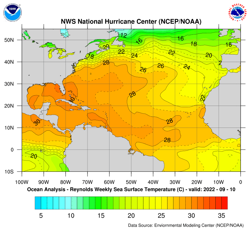
Lastly, it seems like the SSTs are actually at or above 26C already at about 10 degrees, so a low could intensify here if there was enough mid level moisture and low shear. So it's not out of the question at all for a wave or low to periodically flare up some convection out there this early in our 2007 season.

Here's the SSTs:
Image
0 likes   

User avatar
fci
S2K Supporter
S2K Supporter
Posts: 3324
Joined: Tue Sep 14, 2004 10:29 am
Location: Lake Worth, FL

#63 Postby fci » Sat Jun 09, 2007 5:45 pm

I find it interesting that 5:30 PM Tropical Weather Outlooks are published at 4:00 PM! :?:
0 likes   

User avatar
HURAKAN
Professional-Met
Professional-Met
Posts: 46086
Age: 38
Joined: Thu May 20, 2004 4:34 pm
Location: Key West, FL
Contact:

#64 Postby HURAKAN » Sat Jun 09, 2007 5:45 pm

I fully understand that for new members the word "poof" and its derivatives "poofing, poofed, etc" is not very scientific, nonetheless, old members know very the well the meaning of the term "poof" when refering to a tropical system, especially a disturbance. It just means that the system looks to be dissipating based on the fact that the convective pattern is very disorganized and that the intensity of the convection is weak. It's just like in math when you have a big equations and to make it easier, you substitute some of the variables by letters.

When a system is intensifying I always say " the roller coaster is going up," when it's weakening, "the roller coaster is going down." There's no scientific value there, just symbolism.
Last edited by HURAKAN on Sat Jun 09, 2007 6:00 pm, edited 1 time in total.
0 likes   

User avatar
HURAKAN
Professional-Met
Professional-Met
Posts: 46086
Age: 38
Joined: Thu May 20, 2004 4:34 pm
Location: Key West, FL
Contact:

#65 Postby HURAKAN » Sat Jun 09, 2007 5:48 pm

fci wrote:I find it interesting that 5:30 PM Tropical Weather Outlooks are published at 4:00 PM! :?:


Usually when we don't have an active sytem, the TWO is done much earlier. Nevertheless, 4 PM is quite early!!! I guess they wanted dinner early today.
0 likes   

User avatar
AnnularCane
S2K Supporter
S2K Supporter
Posts: 2872
Joined: Thu Jun 08, 2006 9:18 am
Location: Wytheville, VA

#66 Postby AnnularCane » Sat Jun 09, 2007 5:51 pm

HURAKAN wrote:I fully understand that for new members the word "poof" and its derivatives "poofing, pooked, etc" is not very scientific, nonetheless, old members know very the well the meaning of the term "poof" when refering to a tropical system, especially a disturbance. It just means that the system looks to be dissipating based on the fact that the convective pattern is very disorganized and that the intensity of the convection is weak. It's just like in math when you have a big equations and to make it easier, you substitute some of the variables by letters.


Pooked? :lol:
0 likes   

User avatar
HURAKAN
Professional-Met
Professional-Met
Posts: 46086
Age: 38
Joined: Thu May 20, 2004 4:34 pm
Location: Key West, FL
Contact:

#67 Postby HURAKAN » Sat Jun 09, 2007 6:00 pm

AnnularCane wrote:
HURAKAN wrote:I fully understand that for new members the word "poof" and its derivatives "poofing, pooked, etc" is not very scientific, nonetheless, old members know very the well the meaning of the term "poof" when refering to a tropical system, especially a disturbance. It just means that the system looks to be dissipating based on the fact that the convective pattern is very disorganized and that the intensity of the convection is weak. It's just like in math when you have a big equations and to make it easier, you substitute some of the variables by letters.


Pooked? :lol:


I meant, poofed. But I have heard "pooked" before when refering to a dissipating system.
0 likes   

User avatar
dixiebreeze
S2K Supporter
S2K Supporter
Posts: 5140
Joined: Wed Sep 03, 2003 5:07 pm
Location: crystal river, fla.

#68 Postby dixiebreeze » Sat Jun 09, 2007 7:09 pm

Excerpt 8:05 NHC:

...TROPICAL WAVES...

STRONG WELL DEFINED TROPICAL WAVE FOR EARLY JUNE WHICH WAS ADDED
TO THE 12Z SFC ANALYSIS IS CURRENTLY ALONG 16W S OF 15N. THE
LAST VISIBLE SATELLITE IMAGES AND A 1942 UTC QUIKSCAT PASS
SUGGESTS A LOW PRES CENTER ALONG THE WAVE AXIS AT 8N WITH AN
ESTIMATED CENTRAL PRESSURE OF 1009 MB. IN ADDITION...SURFACE
OBSERVATIONS FROM SENEGAL AND GUINEA INDICATE A SECOND LOW
CENTER...1008 MB AT THE NORTHERN END OF THE WAVE NEAR DAKAR.
BASED ON THE LAST 6-12 HOURS OF MOTION THE WAVE APPEARS TO BE
MOVING W NEAR 20 KT. THE WAVE CONSISTS OF WELL DEFINED LOW TO
MID LEVEL CYCLONIC TURNING WITH SCATTERED MODERATE ISOLATED
STRONG BANDED DEEP CONVECTION MAINTAINING ITSELF NEAR THE
ESTIMATED LOW LEVEL CENTER.
0 likes   

User avatar
windstorm99
S2K Supporter
S2K Supporter
Posts: 1578
Age: 47
Joined: Sat May 26, 2007 8:10 am
Location: Miami, Florida
Contact:

#69 Postby windstorm99 » Sat Jun 09, 2007 7:14 pm

Interesting....
0 likes   

User avatar
AtlanticWind
S2K Supporter
S2K Supporter
Posts: 1894
Age: 66
Joined: Sun Aug 08, 2004 9:57 pm
Location: Plantation,Fla

#70 Postby AtlanticWind » Sat Jun 09, 2007 7:17 pm

0 likes   

User avatar
DESTRUCTION5
Category 5
Category 5
Posts: 4423
Age: 43
Joined: Wed Sep 03, 2003 11:25 am
Location: Stuart, FL

#71 Postby DESTRUCTION5 » Sat Jun 09, 2007 7:20 pm

June or not that Cyclonic turning is simply impressive...

http://cimss.ssec.wisc.edu/tropic/real- ... cjava.html
0 likes   
GATOR NATION IS E V E R Y W H E R E !

User avatar
abajan
S2K Supporter
S2K Supporter
Posts: 4238
Joined: Sun Sep 07, 2003 5:10 am
Location: Barbados

#72 Postby abajan » Sat Jun 09, 2007 7:34 pm

No matter how impressive it looks now, it'll run into cooler, less favorable conditions in a few days time.
0 likes   

User avatar
windstorm99
S2K Supporter
S2K Supporter
Posts: 1578
Age: 47
Joined: Sat May 26, 2007 8:10 am
Location: Miami, Florida
Contact:

#73 Postby windstorm99 » Sat Jun 09, 2007 7:38 pm

abajan wrote:No matter how impressive it looks now, it'll run into cooler, less favorable conditions in a few days time.


Actually SST wise those are warm enough to sustian a tropical system.Also upper level winds look pretty favorable in its path.

Windshear map 96hrs out...

Image
0 likes   

Matt-hurricanewatcher

#74 Postby Matt-hurricanewatcher » Sat Jun 09, 2007 7:45 pm

Forget what I said above, this is now 93L. This has developed more convection near its center. I will look at the data to see how developed it is.

http://www.nrlmry.navy.mil/tc_pages/tc_home.html
0 likes   

User avatar
windstorm99
S2K Supporter
S2K Supporter
Posts: 1578
Age: 47
Joined: Sat May 26, 2007 8:10 am
Location: Miami, Florida
Contact:

#75 Postby windstorm99 » Sat Jun 09, 2007 7:49 pm

Here we go again folks!

Image
0 likes   

Matt-hurricanewatcher

#76 Postby Matt-hurricanewatcher » Sat Jun 09, 2007 7:50 pm

Matt-hurricanewatcher wrote:Forget what I said above, this is now 93L. This has developed more convection near its center. I will look at the data to see how developed it is.

http://www.nrlmry.navy.mil/tc_pages/tc_home.html


The overall wind shear over the Eastern Atlantic is way below normal. Also this system is moving around 20 knots...Which is slightly fast, but much slower then the 25-27 knots these systems normallly go. I would watch for some development if it stays south of 12.
0 likes   

Derecho
Category 5
Category 5
Posts: 1011
Joined: Sat Mar 15, 2003 3:15 pm

#77 Postby Derecho » Sat Jun 09, 2007 7:54 pm

abajan wrote:No matter how impressive it looks now, it'll run into cooler, less favorable conditions in a few days time.


Pretty much every model has screaming shear which doesn't move around 45W.

That said, it's several days before it's there.
0 likes   

User avatar
Cyclenall
Category 5
Category 5
Posts: 6667
Joined: Thu Jun 08, 2006 10:01 pm
Location: Ontario, Canada

#78 Postby Cyclenall » Sat Jun 09, 2007 8:27 pm

This is quite something. It's already a invest and it's one of the best looking waves off Africa I've seen...and it's early June. The fact some pro mets are even considering the idea this does have a chance (even a small one) is surprising.
0 likes   

User avatar
dixiebreeze
S2K Supporter
S2K Supporter
Posts: 5140
Joined: Wed Sep 03, 2003 5:07 pm
Location: crystal river, fla.

#79 Postby dixiebreeze » Sat Jun 09, 2007 8:37 pm

Season is ramping up early and I wouldn't be too surprised to see more activity from the S. Caribbean flare-up.
0 likes   

Aric Dunn
Category 5
Category 5
Posts: 21238
Age: 42
Joined: Sun Sep 19, 2004 9:58 pm
Location: Ready for the Chase.
Contact:

#80 Postby Aric Dunn » Sat Jun 09, 2007 8:45 pm

here are a couple decent loops.. they update faster every hour or so .. on this one .. also this one sectors 4 and 5 will give close ups but kind of cut in half .. but watch sector 4 in the upcoming day or so http://oiswww.eumetsat.org/SDDI/cgi/lis ... 0#controls
0 likes   


Return to “Talkin' Tropics”

Who is online

Users browsing this forum: Bobd33, Cpv17, Google Adsense [Bot], wileytheartist and 100 guests