
Weak low in NE Gulf of Mexico: (Is Invest 95L)
Moderator: S2k Moderators
Forum rules

The posts in this forum are NOT official forecasts and should not be used as such. They are just the opinion of the poster and may or may not be backed by sound meteorological data. They are NOT endorsed by any professional institution or STORM2K. For official information, please refer to products from the National Hurricane Center and National Weather Service.
-
bamajammer4eva
- Category 4

- Posts: 907
- Joined: Sun Apr 18, 2010 3:21 am
- Location: Ozark, AL
Re: Weak low in NE Gulf of Mexico
Winds could be strong enough for TD in convection to the south
0 likes

Re: Weak low in NE Gulf of Mexico
Looking much better organized this afternoon, I'm honestly surprised it managed to organize given how close to land it is. Its pretty doubtful that it'll ever get classified, it doesn't meet the 50 mph criteria the NHC seems to be using this season and they've been fairly hesitant to upgrade systems this close to land in recent years as well especially without TS winds or reconnaissance.
Last edited by Hammy on Sun Aug 02, 2015 5:18 pm, edited 1 time in total.
0 likes
The above post is not official and should not be used as such. It is the opinion of the poster and may or may not be backed by sound meteorological data. It is not endorsed by any professional institution or storm2k.org. For official information, please refer to the NHC and NWS products.
-
northjaxpro

- S2K Supporter

- Posts: 8900
- Joined: Mon Sep 27, 2010 11:21 am
- Location: Jacksonville, FL
Wide radar view. This is looking like an organizing tropical cyclone to me! Also, look at that large convective band extending down through the peninsula. Hope that is helping relieve the drought there in portions of South florida.

0 likes
NEVER, EVER SAY NEVER in the tropics and weather in general, and most importantly, with life itself!!
________________________________________________________________________________________
Fay 2008 Beryl 2012 Debby 2012 Colin 2016 Hermine 2016 Julia 2016 Matthew 2016 Irma 2017 Dorian 2019
________________________________________________________________________________________
Fay 2008 Beryl 2012 Debby 2012 Colin 2016 Hermine 2016 Julia 2016 Matthew 2016 Irma 2017 Dorian 2019
-
TheStormExpert
Re: Weak low in NE Gulf of Mexico
Hammy wrote:Looking much better organized this afternoon, I'm honestly surprised it managed to organize given how close to land it is. Its pretty doubtful that it'll ever get classified, it doesn't meet the 50 mph criteria the NHC seems to be using this season and they've been fairly hesitant to upgrade systems this close to land in recent years as well especially without TS winds or reconnaissance.
Why must it be a 50mph TS to be classified?
0 likes
-
TheStormExpert
-
tropicwatch

- Category 5

- Posts: 3426
- Age: 62
- Joined: Sat Jun 02, 2007 10:01 am
- Location: Panama City Florida
- Contact:
Re:
TheStormExpert wrote:I will be REALLY shocked if they do not up the development chances at least at the 8pm TWO.
Or possibly give it a TD status.
0 likes
Tropicwatch
Agnes 72', Eloise 75, Elena 85', Kate 85', Charley 86', Florence 88', Beryl 94', Dean 95', Erin 95', Opal 95', Earl 98', Georges 98', Ivan 2004', Arlene 2005', Dennis 2005', Ida 2009' Debby 2012' Irma 2017' Michael 2018'
Agnes 72', Eloise 75, Elena 85', Kate 85', Charley 86', Florence 88', Beryl 94', Dean 95', Erin 95', Opal 95', Earl 98', Georges 98', Ivan 2004', Arlene 2005', Dennis 2005', Ida 2009' Debby 2012' Irma 2017' Michael 2018'
-
SunnyThoughts
- Category 5
- Posts: 2263
- Joined: Wed Jul 09, 2003 12:42 pm
- Location: Pensacola, Florida
Re: Weak low in NE Gulf of Mexico
TheStormExpert wrote:Hammy wrote:Looking much better organized this afternoon, I'm honestly surprised it managed to organize given how close to land it is. Its pretty doubtful that it'll ever get classified, it doesn't meet the 50 mph criteria the NHC seems to be using this season and they've been fairly hesitant to upgrade systems this close to land in recent years as well especially without TS winds or reconnaissance.
Why must it be a 50mph TS to be classified?
It just seems to be what they're doing this season, a few people even pointed it out with Claudette not getting upgraded until that point.
0 likes
The above post is not official and should not be used as such. It is the opinion of the poster and may or may not be backed by sound meteorological data. It is not endorsed by any professional institution or storm2k.org. For official information, please refer to the NHC and NWS products.

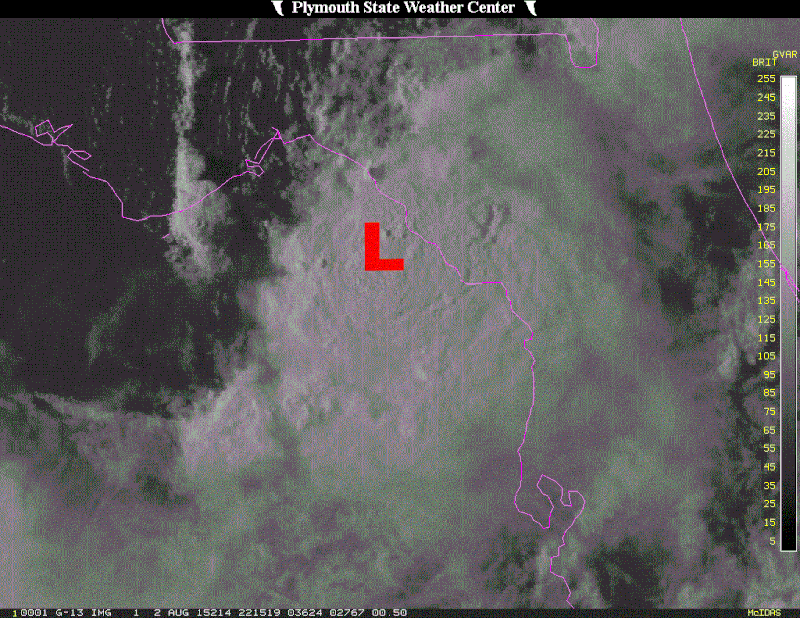
Re: Weak low in NE Gulf of Mexico
I placed the L where the COC was located at the time of the vis satellite pix.
0 likes
-
northjaxpro
- S2K Supporter
- Posts: 8900
- Joined: Mon Sep 27, 2010 11:21 am
- Location: Jacksonville, FL
Low still appears on its southward drift this hour. If the Low continues to drift south the next several hours, that would place the circulation center about due west of the mouth of the Suwannee River. Right now it is about 20 miles due west of Horseshoe Beach looking at the latest radar frame. Remember, it is only moving at 2 to 2.5 mph currently. crawling lol..
0 likes
NEVER, EVER SAY NEVER in the tropics and weather in general, and most importantly, with life itself!!
________________________________________________________________________________________
Fay 2008 Beryl 2012 Debby 2012 Colin 2016 Hermine 2016 Julia 2016 Matthew 2016 Irma 2017 Dorian 2019
________________________________________________________________________________________
Fay 2008 Beryl 2012 Debby 2012 Colin 2016 Hermine 2016 Julia 2016 Matthew 2016 Irma 2017 Dorian 2019
-
Stormcenter
- S2K Supporter
- Posts: 6685
- Joined: Wed Sep 03, 2003 11:27 am
- Location: Houston, TX
Re: Weak low in NE Gulf of Mexico
I still find the large complex SW of our low interesting today.
http://www.ssd.noaa.gov/goes/east/gmex/flash-vis.html
http://www.ssd.noaa.gov/goes/east/gmex/flash-vis.html
0 likes

Re: Weak low in NE Gulf of Mexico
The surface pressure is dropping and the winds are picking up at the Tampa bay buoy.
25 - knot winds fairly far from the circulation center.
http://www.ndbc.noaa.gov/station_page.php?station=42036
25 - knot winds fairly far from the circulation center.
http://www.ndbc.noaa.gov/station_page.php?station=42036
0 likes
-
Stormcenter
- S2K Supporter
- Posts: 6685
- Joined: Wed Sep 03, 2003 11:27 am
- Location: Houston, TX
It just occurred to me, but looping the one-hour totals on NWS radar can be used to get a general idea of the center location.
0 likes
The above post is not official and should not be used as such. It is the opinion of the poster and may or may not be backed by sound meteorological data. It is not endorsed by any professional institution or storm2k.org. For official information, please refer to the NHC and NWS products.
-
Dean4Storms
- S2K Supporter
- Posts: 6358
- Age: 62
- Joined: Sun Aug 31, 2003 1:01 pm
- Location: Miramar Bch. FL
Re: Re:
Stormcenter wrote:I agreeTheStormExpert wrote:Is it me or does it look to be less definable on radar?
Looks that way because Convection has fired over the center, you don't see the little bands spiraling around a hole so easily now.
0 likes
-
Dean4Storms
- S2K Supporter
- Posts: 6358
- Age: 62
- Joined: Sun Aug 31, 2003 1:01 pm
- Location: Miramar Bch. FL
-
tropicwatch
- Category 5
- Posts: 3426
- Age: 62
- Joined: Sat Jun 02, 2007 10:01 am
- Location: Panama City Florida
- Contact:
Look at the difference in water levels at Paradise Point on the Crystal River.


Last edited by tropicwatch on Sun Aug 02, 2015 6:02 pm, edited 1 time in total.
0 likes
Tropicwatch
Agnes 72', Eloise 75, Elena 85', Kate 85', Charley 86', Florence 88', Beryl 94', Dean 95', Erin 95', Opal 95', Earl 98', Georges 98', Ivan 2004', Arlene 2005', Dennis 2005', Ida 2009' Debby 2012' Irma 2017' Michael 2018'
Agnes 72', Eloise 75, Elena 85', Kate 85', Charley 86', Florence 88', Beryl 94', Dean 95', Erin 95', Opal 95', Earl 98', Georges 98', Ivan 2004', Arlene 2005', Dennis 2005', Ida 2009' Debby 2012' Irma 2017' Michael 2018'
-
JKingTampa

- Tropical Storm

- Posts: 101
- Joined: Wed Sep 10, 2014 8:16 pm
- Location: St. Petersburg, FL
-
hurricanekid416
- Tropical Storm
- Posts: 179
- Joined: Wed Oct 24, 2012 2:43 pm
So how much time does it have on water
0 likes
Personal Forecast Disclaimer:
The posts in this forum are NOT official forecast and should not be used as such. They are just the opinion of the poster and may or may not be backed by sound meteorological data. They are NOT endorsed by any professional institution or storm2k.org. For official information, please refer to the NHC and NWS products.
The posts in this forum are NOT official forecast and should not be used as such. They are just the opinion of the poster and may or may not be backed by sound meteorological data. They are NOT endorsed by any professional institution or storm2k.org. For official information, please refer to the NHC and NWS products.
Who is online
Users browsing this forum: Yellow Evan and 70 guests