2018 Tropics: Global Model Runs Discussion (Out to day 16)

This is the general tropical discussion area. Anyone can take their shot at predicting a storms path.

Moderator: S2k Moderators

Forum rules

The posts in this forum are NOT official forecasts and should not be used as such. They are just the opinion of the poster and may or may not be backed by sound meteorological data. They are NOT endorsed by any professional institution or STORM2K. For official information, please refer to products from the National Hurricane Center and National Weather Service.

Help Support Storm2K
Message
Author
LarryWx
S2K Supporter
S2K Supporter
Posts: 6310
Joined: Sun Sep 07, 2003 2:04 pm
Location: GA

Re: 2018 Tropics: Global Model Runs Discussion (Out to day 16)

#601 Postby LarryWx » Wed Jun 06, 2018 9:39 am

LarryWx wrote:The 12Z GFS has nothing around 6/10. Being that we're now within 5 days, I think this 6/10 W Caribbean genesis that a number of days in a row of GFS runs were persistent with until just a couple of days ago can just about be Dr. McCoy'ed. Even the recent GEFS runs have shown only limited support.


I'm bumping this. The system on today's 6Z GFS, which has a genesis in the SW Car 6/11-12 and then moves NNW into the NW Car 6/13, compares to the GFS for a number of days insisting on every run a genesis in the NW Car on 6/10. That is not consistent. This run has nothing in the NW Car 6/10.

Edit: the GEFS runs were also for EVERY run showing for a good number of days a decent portion of members with genesis on 6/10 in the NW Car and then hitting FL 6/11-13. There are no members doing this on the 6Z GEFS.
1 likes   
Personal Forecast Disclaimer:
The posts in this forum are NOT official forecasts and should not be used as such. They are just the opinion of the poster and may or may not be backed by sound meteorological data. They are NOT endorsed by any professional institution or storm2k.org. For official information, please refer to the NHC and NWS products.

Aric Dunn
Category 5
Category 5
Posts: 21238
Age: 42
Joined: Sun Sep 19, 2004 9:58 pm
Location: Ready for the Chase.
Contact:

Re: 2018 Tropics: Global Model Runs Discussion (Out to day 16)

#602 Postby Aric Dunn » Wed Jun 06, 2018 10:05 am

LarryWx wrote:
LarryWx wrote:The 12Z GFS has nothing around 6/10. Being that we're now within 5 days, I think this 6/10 W Caribbean genesis that a number of days in a row of GFS runs were persistent with until just a couple of days ago can just about be Dr. McCoy'ed. Even the recent GEFS runs have shown only limited support.


I'm bumping this. The system on today's 6Z GFS, which has a genesis in the SW Car 6/11-12 and then moves NNW into the NW Car 6/13, compares to the GFS for a number of days insisting on every run a genesis in the NW Car on 6/10. That is not consistent. This run has nothing in the NW Car 6/10.

Edit: the GEFS runs were also for EVERY run showing for a good number of days a decent portion of members with genesis on 6/10 in the NW Car and the hitting FL 6/11-13. There are no members doing this on the 6Z GEFS.


I am not exactly sure what you were trying to say. but the GFS still has the vorticity and beginnings still starting between the 9th and 11th. which is extremely consistent. the differences in how well defined it has been run to run is irrelevant. a number of issues could lead to that but it does not take away from the constancy from run to run in terms of timing. unlike Alberto which the GFS push back farther and farther. it has not done it with this system. it has continued to show the monsoon trough combined with a tropical wave in the SW carrib moves north then develops... either way it is the same mechanism throughout.
0 likes   
Note: If I make a post that is brief. Please refer back to previous posts for the analysis or reasoning. I do not re-write/qoute what my initial post said each time.
If there is nothing before... then just ask :)

Space & Atmospheric Physicist, Embry-Riddle Aeronautical University,
I believe the sky is falling...

User avatar
gatorcane
S2K Supporter
S2K Supporter
Posts: 23691
Age: 47
Joined: Sun Mar 13, 2005 3:54 pm
Location: Boca Raton, FL

Re: 2018 Tropics: Global Model Runs Discussion (Out to day 16)

#603 Postby gatorcane » Wed Jun 06, 2018 10:15 am

The 00Z UKMET is showing something also now in the SW Caribbean along the lines of the GFS. Not buying into development yet but looks like the ECMWF is the only model at the moment not showing at least some kind of broad low that forms in the SW Caribbean in about a week:

Image
1 likes   

LarryWx
S2K Supporter
S2K Supporter
Posts: 6310
Joined: Sun Sep 07, 2003 2:04 pm
Location: GA

Re: 2018 Tropics: Global Model Runs Discussion (Out to day 16)

#604 Postby LarryWx » Wed Jun 06, 2018 10:24 am

Aric Dunn wrote:
LarryWx wrote:
LarryWx wrote:The 12Z GFS has nothing around 6/10. Being that we're now within 5 days, I think this 6/10 W Caribbean genesis that a number of days in a row of GFS runs were persistent with until just a couple of days ago can just about be Dr. McCoy'ed. Even the recent GEFS runs have shown only limited support.


I'm bumping this. The system on today's 6Z GFS, which has a genesis in the SW Car 6/11-12 and then moves NNW into the NW Car 6/13, compares to the GFS for a number of days insisting on every run a genesis in the NW Car on 6/10. That is not consistent. This run has nothing in the NW Car 6/10.

Edit: the GEFS runs were also for EVERY run showing for a good number of days a decent portion of members with genesis on 6/10 in the NW Car and the hitting FL 6/11-13. There are no members doing this on the 6Z GEFS.


I am not exactly sure what you were trying to say. but the GFS still has the vorticity and beginnings still starting between the 9th and 11th. which is extremely consistent. the differences in how well defined it has been run to run is irrelevant. a number of issues could lead to that but it does not take away from the constancy from run to run in terms of timing. unlike Alberto which the GFS push back farther and farther. it has not done it with this system. it has continued to show the monsoon trough combined with a tropical wave in the SW carrib moves north then develops... either way it is the same mechanism throughout.


Aric,
I'm simply saying that the GFS/GEFS had until 3 days ago on EVERY run for day after day explicit closed surface lows/TC geneses in the NW Caribbean on 6/10 as many posts back then in this thread show. The 6Z GFS/GEFS is not doing that with nothing in the NW Caribbean 6/10 or even on 6/11. This represents time slippage. I'm sticking with the idea of only a small chance for development in the W Car 6/10-13 for now based on the inconsistent/slipping GFS suite as well as the continued lack of support from the Euro suite. That being said, the W Car still needs to be watched as 6/11-20 has 26 geneses on record since 1851, about as many within 10 days as any into August.
0 likes   
Personal Forecast Disclaimer:
The posts in this forum are NOT official forecasts and should not be used as such. They are just the opinion of the poster and may or may not be backed by sound meteorological data. They are NOT endorsed by any professional institution or storm2k.org. For official information, please refer to the NHC and NWS products.

Aric Dunn
Category 5
Category 5
Posts: 21238
Age: 42
Joined: Sun Sep 19, 2004 9:58 pm
Location: Ready for the Chase.
Contact:

Re: 2018 Tropics: Global Model Runs Discussion (Out to day 16)

#605 Postby Aric Dunn » Wed Jun 06, 2018 10:30 am

LarryWx wrote:
Aric Dunn wrote:
LarryWx wrote:
I'm bumping this. The system on today's 6Z GFS, which has a genesis in the SW Car 6/11-12 and then moves NNW into the NW Car 6/13, compares to the GFS for a number of days insisting on every run a genesis in the NW Car on 6/10. That is not consistent. This run has nothing in the NW Car 6/10.

Edit: the GEFS runs were also for EVERY run showing for a good number of days a decent portion of members with genesis on 6/10 in the NW Car and the hitting FL 6/11-13. There are no members doing this on the 6Z GEFS.


I am not exactly sure what you were trying to say. but the GFS still has the vorticity and beginnings still starting between the 9th and 11th. which is extremely consistent. the differences in how well defined it has been run to run is irrelevant. a number of issues could lead to that but it does not take away from the constancy from run to run in terms of timing. unlike Alberto which the GFS push back farther and farther. it has not done it with this system. it has continued to show the monsoon trough combined with a tropical wave in the SW carrib moves north then develops... either way it is the same mechanism throughout.


Aric,
I'm simply saying that the GFS/GEFS had until 3 days ago on EVERY run for day after day explicit closed surface lows/TC geneses in the NW Caribbean on 6/10 as many posts back then in this thread show. The 6Z GFS/GEFS is not doing that with nothing in the NW Caribbean 6/10 or even on 6/11. This represents time slippage. I'm sticking with the idea of only a small chance for development in the W Car 6/10-13 for now based on the inconsistent/slipping GFS suite as well as the continued lack of support from the Euro suite. That being said, the W Car still needs to be watched as 6/11-20 has 26 geneses on record since 1851, about as many within 10 days as any into August.


Well the 6z does have the broad circ still there in the sw carrib on the 10th. Only problem is the monsoon trough/gyre is mostly over land. So no time slippage. Just slightly different placement causing a 12 to 18 difference .. which is normal. Same mechanisms as the previous week.of the gfs.
0 likes   
Note: If I make a post that is brief. Please refer back to previous posts for the analysis or reasoning. I do not re-write/qoute what my initial post said each time.
If there is nothing before... then just ask :)

Space & Atmospheric Physicist, Embry-Riddle Aeronautical University,
I believe the sky is falling...

User avatar
MississippiWx
S2K Supporter
S2K Supporter
Posts: 1699
Joined: Sat Aug 14, 2010 1:44 pm
Location: Hattiesburg, Mississippi

Re: 2018 Tropics: Global Model Runs Discussion (Out to day 16)

#606 Postby MississippiWx » Wed Jun 06, 2018 10:34 am

The Western Caribbean is certainly a climatologically favored area. However, there has still been no significant jump up in time frame yet. I’d still take this with a grain of salt.
1 likes   
This post is not an official forecast and should not be used as such. It is just the opinion of MississippiWx and may or may not be backed by sound meteorological data. It is not endorsed by any professional institution including storm2k.org. For Official Information please refer to the NHC and NWS products.

Aric Dunn
Category 5
Category 5
Posts: 21238
Age: 42
Joined: Sun Sep 19, 2004 9:58 pm
Location: Ready for the Chase.
Contact:

Re: 2018 Tropics: Global Model Runs Discussion (Out to day 16)

#607 Postby Aric Dunn » Wed Jun 06, 2018 10:36 am

MississippiWx wrote:The Western Caribbean is certainly a climatologically favored area. However, there has still been no significant jump up in time frame yet. I’d still take this with a grain of salt.

Jump up in time frame ?
0 likes   
Note: If I make a post that is brief. Please refer back to previous posts for the analysis or reasoning. I do not re-write/qoute what my initial post said each time.
If there is nothing before... then just ask :)

Space & Atmospheric Physicist, Embry-Riddle Aeronautical University,
I believe the sky is falling...

LarryWx
S2K Supporter
S2K Supporter
Posts: 6310
Joined: Sun Sep 07, 2003 2:04 pm
Location: GA

Re: 2018 Tropics: Global Model Runs Discussion (Out to day 16)

#608 Postby LarryWx » Wed Jun 06, 2018 10:41 am

bamajammer4eva wrote:Models in image at 180 hrs NAVGEM, GFS, GEFS

https://i.imgur.com/gEova9O.png


For Aric and others, I'm bumping this 6/3 post, which illustrates well that explicit surface lows were being modeled in the NW (not SW) Caribbean as of 12Z on 6/10 on the 0Z 6/3 GFS/GEFS (and the Navgem). This is but one run of many GFS/GEFS in a row that had been showing something similar for several days of runs in a row. Just looking at the most recent GEFS runs clearly shows they have nothing of the sort in the NW Caribbean on 6/10. That's why I'm confident that forecast time has slipped on the GFS suite. As mentioned, this doesn't mean I'm saying no chance for TC genesis in mid June but rather is supportive of my feeling of only a small chance as of now. Mid June relatively active W Car climo needs to be respected.
Last edited by LarryWx on Wed Jun 06, 2018 10:58 am, edited 1 time in total.
0 likes   
Personal Forecast Disclaimer:
The posts in this forum are NOT official forecasts and should not be used as such. They are just the opinion of the poster and may or may not be backed by sound meteorological data. They are NOT endorsed by any professional institution or storm2k.org. For official information, please refer to the NHC and NWS products.

Aric Dunn
Category 5
Category 5
Posts: 21238
Age: 42
Joined: Sun Sep 19, 2004 9:58 pm
Location: Ready for the Chase.
Contact:

Re: 2018 Tropics: Global Model Runs Discussion (Out to day 16)

#609 Postby Aric Dunn » Wed Jun 06, 2018 10:57 am

LarryWx wrote:
bamajammer4eva wrote:Models in image at 180 hrs NAVGEM, GFS, GEFS

https://i.imgur.com/gEova9O.png


For Aric and others, I'm bumping this 6/3 post, which illustrates well that explicit surface lows were being modeled in the NW (not SW) Caribbean as of 12Z on 6/10 on the 0Z 6/3 GFS/GEFS (and the Navgem). This is but one run of many GFS/GEFS in a row that had been showing something similar for several days of runs in a row. Just looking at the most recent GEFS runs clearly shows they have nothing of the sort in the NW Caribbean on 6/10.


I guess what your not seeing is that the development all orginated from the sw carrib as the monsoon trough lifts north and then a tropical wave moves into the western.carrib
western.carrib. just because earlier runs only show development in the nw carrib does not mean there time slippage as.you say ... which i assume your refering to feature being a phantom of the models. It is still 7 days out and models are going to change slightly. I hardly call 12 to 24hrs a huge shift. When actually the models are becoming more refined. Unlike with alberto being pushed back nearly a week from the intitial run showing development.. 1 day do to location of the monsoon trough is normal variations in parameters. There is still alot that has to happen. I.e the location and speed and strength of the next next east pac system postition of the upper/mid levl trough over gulf etc...

So far the gfs has been well within typical variations unlike with alberto.
0 likes   
Note: If I make a post that is brief. Please refer back to previous posts for the analysis or reasoning. I do not re-write/qoute what my initial post said each time.
If there is nothing before... then just ask :)

Space & Atmospheric Physicist, Embry-Riddle Aeronautical University,
I believe the sky is falling...

User avatar
CyclonicFury
Category 5
Category 5
Posts: 2025
Age: 26
Joined: Sun Jul 02, 2017 12:32 pm
Location: NC
Contact:

Re: 2018 Tropics: Global Model Runs Discussion (Out to day 16)

#610 Postby CyclonicFury » Wed Jun 06, 2018 11:26 am

12z GFS and CMC both develop a weak tropical cyclone over the NW Caribbean by the middle of next week.
1 likes   
NCSU B.S. in Meteorology Class of 2021. Tropical weather blogger at http://www.cyclonicfury.com. My forecasts and thoughts are NOT official, for official forecasts please consult the National Hurricane Center.

User avatar
gatorcane
S2K Supporter
S2K Supporter
Posts: 23691
Age: 47
Joined: Sun Mar 13, 2005 3:54 pm
Location: Boca Raton, FL

Re: 2018 Tropics: Global Model Runs Discussion (Out to day 16)

#611 Postby gatorcane » Wed Jun 06, 2018 11:31 am

The Canadian is more bullish in the GOM:

Image
1 likes   

TheStormExpert

Re: 2018 Tropics: Global Model Runs Discussion (Out to day 16)

#612 Postby TheStormExpert » Wed Jun 06, 2018 11:41 am

The 12z GFS is slightly weaker into the Mobile Alabama area likely due to more land interaction with western Cuba.
1 likes   

User avatar
MGC
S2K Supporter
S2K Supporter
Posts: 5899
Joined: Sun Mar 23, 2003 9:05 pm
Location: Pass Christian MS, or what is left.

Re: 2018 Tropics: Global Model Runs Discussion (Out to day 16)

#613 Postby MGC » Wed Jun 06, 2018 11:46 am

12Z GFS has a 979mb cane hitting near Gulf Shores on June 15th. Doubt it but we shall see.....MGC
1 likes   

Alyono
Professional-Met
Professional-Met
Posts: 6961
Joined: Fri Apr 26, 2013 3:52 pm
Location: Texas Coast

Re: 2018 Tropics: Global Model Runs Discussion (Out to day 16)

#614 Postby Alyono » Wed Jun 06, 2018 11:46 am

GFS is weaker because it is faster. Thing is intensifying steadily until landfall. It just landfalls a bit earlier this run
2 likes   

LarryWx
S2K Supporter
S2K Supporter
Posts: 6310
Joined: Sun Sep 07, 2003 2:04 pm
Location: GA

Re: 2018 Tropics: Global Model Runs Discussion (Out to day 16)

#615 Postby LarryWx » Wed Jun 06, 2018 12:17 pm

The 12Z GFS doesn't have genesis til 6/11 and that is in the SW Caribbean. In contrast, about every run of the GFS on the days leading up to 6/3 as well as a good % of members of the respective GEFS runs had genesis on 6/10 in the NW Caribbean. Today's 12Z GFS isn't in the NW Caribbean til 3 days later or 6/13. As many here were thinking and posting just yesterday including pro met wxman57, this could easily still end up as overdone or even a flat out phantom. Until there's better model consensus for the same timeframe, I continue to recommend being wary about a possible phantom.

I'm keeping chances low but not zero (mainly in deference to relatively active climo but also somewhat due to the GFS despite time slippage) for now.
1 likes   
Personal Forecast Disclaimer:
The posts in this forum are NOT official forecasts and should not be used as such. They are just the opinion of the poster and may or may not be backed by sound meteorological data. They are NOT endorsed by any professional institution or storm2k.org. For official information, please refer to the NHC and NWS products.

Aric Dunn
Category 5
Category 5
Posts: 21238
Age: 42
Joined: Sun Sep 19, 2004 9:58 pm
Location: Ready for the Chase.
Contact:

Re: 2018 Tropics: Global Model Runs Discussion (Out to day 16)

#616 Postby Aric Dunn » Wed Jun 06, 2018 12:31 pm

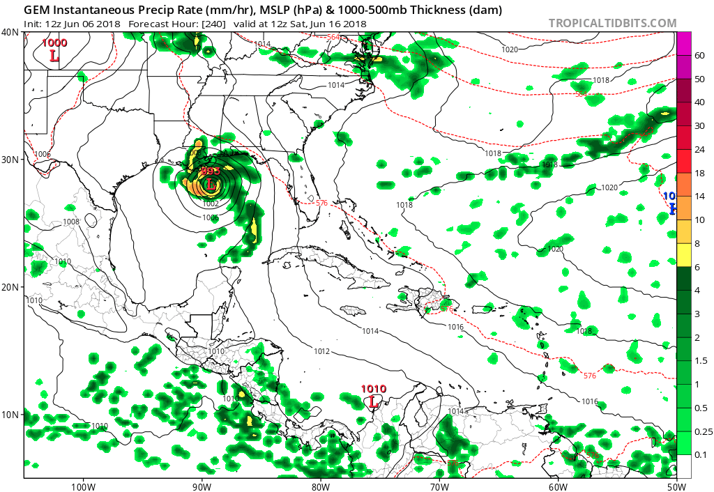
LarryWx wrote:The 12Z GFS doesn't have genesis til 6/11 and that is in the SW Caribbean. In contrast, about every run of the GFS on the days leading up to 6/3 as well as a good % of members of the respective GEFS runs had genesis on 6/10 in the NW Caribbean. Today's 12Z GFS isn't in the NW Caribbean til 3 days later or 6/13. As many here were thinking and posting just yesterday including pro met Weather57, this could easily still end up as overdone or even a flat out phantom. Until there's better model consensus for the same timeframe, I continue to recommend being wary about a possible phantom.

I'm keeping chances low but not zero (mainly in deference to relatively active climo but also somewhat due to the GFS despite time slippage) for now.


Again I just checked the 850mb vorticity ofr the gfs back to saturday. annndd each and every run the system started in the SW Carrib .. in some cases it moved over land then redeveloped in the NW carrib( meaning it was faster do to the redevelopment). IN other cases it was a loose broad vorticity that took time to develop in the NW carrib. THe recent runs of the GFS ONLY differ by no more than 24 hrs (in terms of the first signs of vorticity) that is hardly what you would call time slippage. and if you really pay attention, THis is the important part. its not a matter of a phantom system. since it is the same mechanism each and every time. only the location of the monsoon trough has changed.

with alberto that was time slippage.. at least 3 seperate tropical waves ( different mechanisms) came into play while it slowly got going. and the GFS slipped about a week or more when development happened compared to early runs.

Also the other factor in terms of the monsoon trough.. the eastern pacific system with the GFS is stronger and buckles the monsoon trough faster and brings it north more in some earlier runs vs now.

some are confusing the the same apple with an orange. even though its always just been an apple. :)
2 likes   
Note: If I make a post that is brief. Please refer back to previous posts for the analysis or reasoning. I do not re-write/qoute what my initial post said each time.
If there is nothing before... then just ask :)

Space & Atmospheric Physicist, Embry-Riddle Aeronautical University,
I believe the sky is falling...

Weather150
Tropical Storm
Tropical Storm
Posts: 190
Joined: Fri Jul 07, 2017 7:46 pm

Re: 2018 Tropics: Global Model Runs Discussion (Out to day 16)

#617 Postby Weather150 » Wed Jun 06, 2018 12:55 pm

12z GFS ensembles didn't show much of anything.
0 likes   

LarryWx
S2K Supporter
S2K Supporter
Posts: 6310
Joined: Sun Sep 07, 2003 2:04 pm
Location: GA

Re: 2018 Tropics: Global Model Runs Discussion (Out to day 16)

#618 Postby LarryWx » Wed Jun 06, 2018 12:56 pm

Aric,
Excellent discussion. Our perspectives on this may not agree, but at least we're being civil/respectful to each other. That's not always the case on other forums and sometimes even here. I do respect your knowledge and many years of experience here.

That being said, I want to point out that the 12Z 5/6 GEFS for 12Z on 6/10 looks nothing like the 0Z 5/3 GEFS that I bumped a little while ago just a little above here in post #608. The 0Z 5/3 GEFS map for 6/10 had a good number of members with an actual TC in the NW Caribbean on the way to threatening FL. The 12Z 5/6 GEFS (just released) has nothing of the sort. It merely has some members with VERY weak surface low way down in the far S Caribbean about 1,000 miles to the south. It finally has some lows (and they're very weak) in the NW Caribbean on 6/13.

Edit: Here is the image from the bammajammer post I bumped showing the 0Z 6/3 runs of the GFS/GEFS/NAVGEM showing the maps for 12Z on 6/10:
https://m.imgur.com/gEova9O
Last edited by LarryWx on Wed Jun 06, 2018 1:10 pm, edited 2 times in total.
6 likes   
Personal Forecast Disclaimer:
The posts in this forum are NOT official forecasts and should not be used as such. They are just the opinion of the poster and may or may not be backed by sound meteorological data. They are NOT endorsed by any professional institution or storm2k.org. For official information, please refer to the NHC and NWS products.

Weather150
Tropical Storm
Tropical Storm
Posts: 190
Joined: Fri Jul 07, 2017 7:46 pm

Re: 2018 Tropics: Global Model Runs Discussion (Out to day 16)

#619 Postby Weather150 » Wed Jun 06, 2018 12:59 pm

LarryWx wrote:Aric,
Excellent discussion. Our perspectives on this may not agree, but at least we're being civil/respectful to each other. That's not always the case on other forums and sometimes even here. I do respect your knowledge and many years of experience here.

That being said, I want to point out that the 12Z 5/6 GEFS for 12Z on 6/10 looks nothing like the 0Z 5/3 GEFS that I bumped earlier today. The 0Z 5/3 GEFS map for 6/10 had a good number of members with an actual TC in the NW Caribbean on the way to threatening FL. The 12Z 5/6 GEFS (just released) has nothing of the sort. It merely has some members with VERY weak surface low way down in the far S Caribbean about 1,000 miles to the south. It finally has some lows (and they're very weak) in the NW Caribbean on 6/13.

Pretty decent decrease.
0 likes   

User avatar
MississippiWx
S2K Supporter
S2K Supporter
Posts: 1699
Joined: Sat Aug 14, 2010 1:44 pm
Location: Hattiesburg, Mississippi

Re: 2018 Tropics: Global Model Runs Discussion (Out to day 16)

#620 Postby MississippiWx » Wed Jun 06, 2018 1:05 pm

Aric Dunn wrote:
MississippiWx wrote:The Western Caribbean is certainly a climatologically favored area. However, there has still been no significant jump up in time frame yet. I’d still take this with a grain of salt.

Jump up in time frame ?


Yeah, same thing Larry is pointing out. Genesis keeps getting pushed back. I stick by what I’ve said that the GFS could be jumping the gun. It has already pushed genesis back by 3 days. The CMC jumping onboard is interesting, but that model too is genesis-happy. We will see.
1 likes   
This post is not an official forecast and should not be used as such. It is just the opinion of MississippiWx and may or may not be backed by sound meteorological data. It is not endorsed by any professional institution including storm2k.org. For Official Information please refer to the NHC and NWS products.


Return to “Talkin' Tropics”

Who is online

Users browsing this forum: jaguars_22, Majestic-12 [Bot], Sps123 and 49 guests