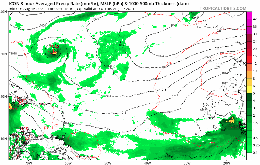
GFS also tries to get something going in the subtropics in the long range (after 96L)
Moderator: S2k Moderators


toad strangler wrote:12z GFS LONG range shows a hurricane meandering around the subtropics well off the CONUS SE coast.

toad strangler wrote:12z GFS LONG range shows a hurricane meandering around the subtropics well off the CONUS SE coast.


SFLcane wrote:toad strangler wrote:12z GFS LONG range shows a hurricane meandering around the subtropics well off the CONUS SE coast.
https://i.postimg.cc/gjSZfG8J/35-B56-C01-D253-4675-B24-F-35-BCCD1-F0-DA0.png
https://i.postimg.cc/TPzQ4JGS/D238-DE1-D-FEA1-495-A-A3-DA-3814-A736-A7-C7.png


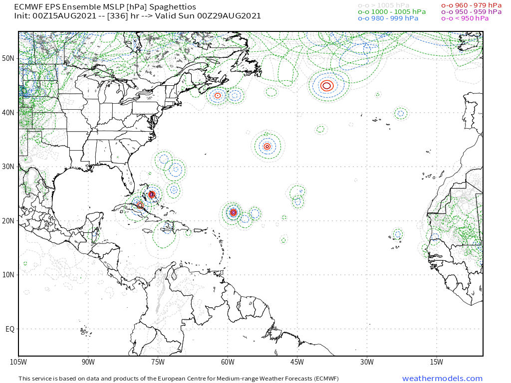
SFLcane wrote:Pretty good signal for next cv wave this morning on the European ensembles.
https://i.postimg.cc/fLcd5hGb/2-A38-EB60-D0-CB-40-D1-B791-4-E459-AB49-FAA.gif
AutoPenalti wrote:SFLcane wrote:Pretty good signal for next cv wave this morning on the European ensembles.
https://i.postimg.cc/fLcd5hGb/2-A38-EB60-D0-CB-40-D1-B791-4-E459-AB49-FAA.gif
I'm starting to think a lot of waves this year will suffer from the AEJ flow which sort of acts as a caveat for development and explains why all 3 storms tangled or, in the case of Grace, will tangle with Hispanola.
SFLcane wrote:AutoPenalti wrote:SFLcane wrote:Pretty good signal for next cv wave this morning on the European ensembles.
https://i.postimg.cc/fLcd5hGb/2-A38-EB60-D0-CB-40-D1-B791-4-E459-AB49-FAA.gif
I'm starting to think a lot of waves this year will suffer from the AEJ flow which sort of acts as a caveat for development and explains why all 3 storms tangled or, in the case of Grace, will tangle with Hispanola.
At some point though the ridge will break down a little.
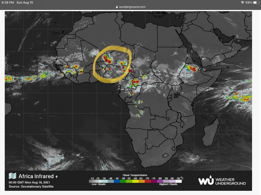
gatorcane wrote:I would keep a close eye on the wave I circled over Africa which has noticeable spin already. The GFS developed this wave on the 12Z in the long-range and the Euro moved it likely too far north coming off Africa, so failed to develop. Models might start to latch onto this one in subsequent runs.
Source which has an “animate” button: https://www.wunderground.com/maps/satel ... ared/afric
https://i.postimg.cc/fR72pw7D/F2-D0-D14-D-7080-4-D4-D-A653-FF2-C6152-CFF2.jpg
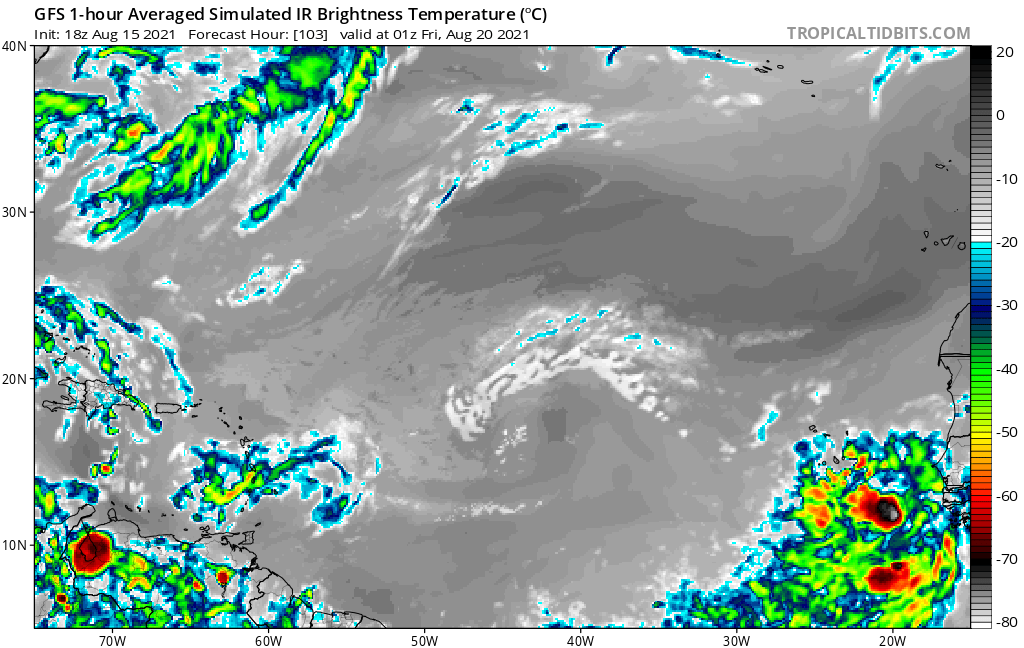
18Z GFS depiction of wave just off the coast of Africa:
https://i.postimg.cc/nc9LtLL8/gfs-ir-eatl-18.png
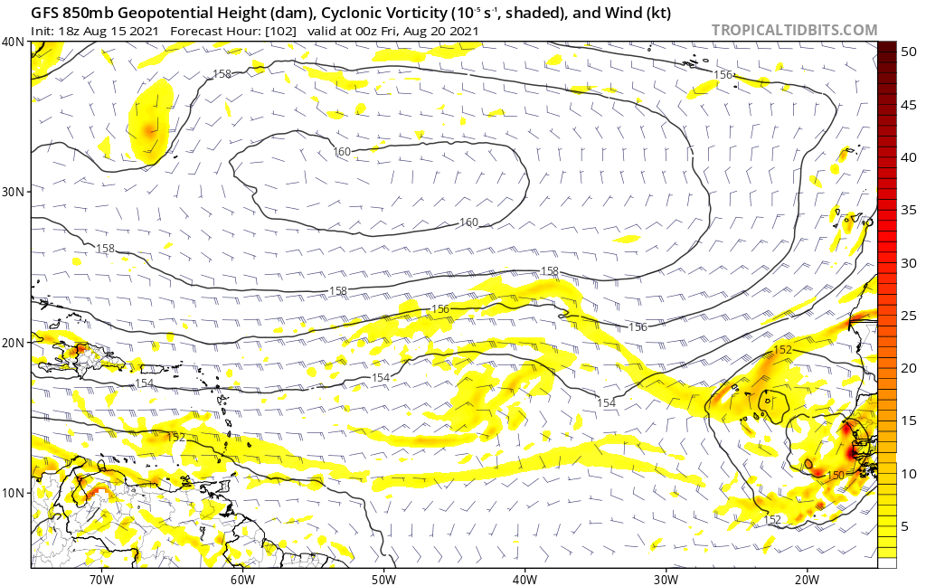
18Z GFS 850mb forecast showing a broad low with distinct spin:
https://i.postimg.cc/4dngb87C/gfs-z850-vort-eatl-18.png
gatorcane wrote:gatorcane wrote:I would keep a close eye on the wave I circled over Africa which has noticeable spin already. The GFS developed this wave on the 12Z in the long-range and the Euro moved it likely too far north coming off Africa, so failed to develop. Models might start to latch onto this one in subsequent runs.
Source which has an “animate” button: https://www.wunderground.com/maps/satel ... ared/afric
https://i.postimg.cc/fR72pw7D/F2-D0-D14-D-7080-4-D4-D-A653-FF2-C6152-CFF2.jpg
18Z GFS depiction of wave just off the coast of Africa:
https://i.postimg.cc/nc9LtLL8/gfs-ir-eatl-18.png
18Z GFS 850mb forecast showing a broad low with distinct spin:
https://i.postimg.cc/4dngb87C/gfs-z850-vort-eatl-18.png
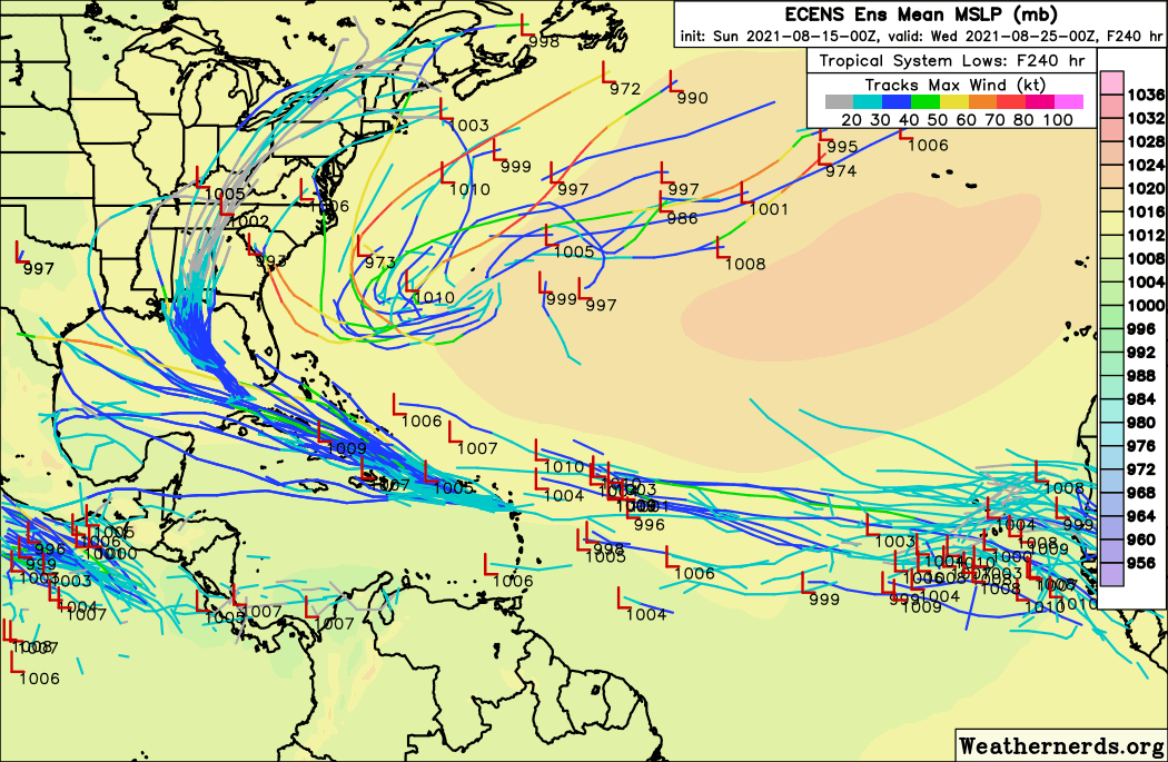
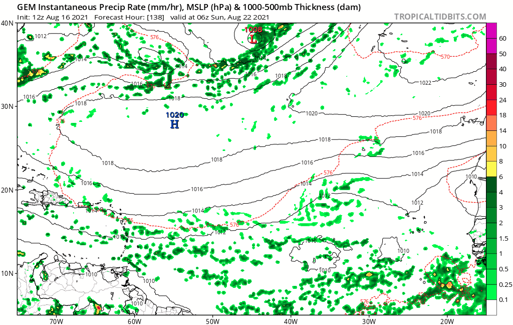
The CMC is on board for the first time:
https://i.postimg.cc/wMg2Db4g/gem-mslp-pcpn-eatl-fh138-240.gif

SFLcane wrote:gatorcane wrote:gatorcane wrote:I would keep a close eye on the wave I circled over Africa which has noticeable spin already. The GFS developed this wave on the 12Z in the long-range and the Euro moved it likely too far north coming off Africa, so failed to develop. Models might start to latch onto this one in subsequent runs.
Source which has an “animate” button: https://www.wunderground.com/maps/satel ... ared/afric
https://i.postimg.cc/fR72pw7D/F2-D0-D14-D-7080-4-D4-D-A653-FF2-C6152-CFF2.jpg
18Z GFS depiction of wave just off the coast of Africa:
https://i.postimg.cc/nc9LtLL8/gfs-ir-eatl-18.png
18Z GFS 850mb forecast showing a broad low with distinct spin:
https://i.postimg.cc/4dngb87C/gfs-z850-vort-eatl-18.png
The CMC is on board for the first time:
https://i.postimg.cc/wMg2Db4g/gem-mslp-pcpn-eatl-fh138-240.gif
There we go.
lsuhurricane wrote:Some decent agreement between the above CMC storm at 240 hours and a few 12z Euro Ensembles.
All appear to be headed due west with stout ridging their north. Would certainly match climatology for that last week of August.
Users browsing this forum: No registered users and 166 guests