Low pressure developing over the western Caribbean Sea (Is Invest 97L)
Moderator: S2k Moderators
Forum rules

The posts in this forum are NOT official forecasts and should not be used as such. They are just the opinion of the poster and may or may not be backed by sound meteorological data. They are NOT endorsed by any professional institution or STORM2K. For official information, please refer to products from the National Hurricane Center and National Weather Service.
Re: Area of low pressure to develop over the western Caribbean sea (0/50)
Convection still looks very impressive in the Caribbean. Looks higher than 50% to me.
0 likes
-
Stratton23
- Category 5

- Posts: 3563
- Joined: Fri Jul 21, 2023 10:59 pm
- Location: Katy, Tx
Re: Area of low pressure to develop over the western Caribbean sea (0/50)
NOAA has a highlighted risk zone of heavy rain and high winds all the way from the florida panhandle to the middle texas coast, that tells me all i need to know lol, could be a very large system
1 likes
-
Frank P
- S2K Supporter

- Posts: 2779
- Joined: Fri Aug 29, 2003 10:52 am
- Location: Biloxi Beach, Ms
- Contact:
Re: Area of low pressure to develop over the western Caribbean sea (0/50)
Stratton23 wrote:NOAA has a highlighted risk zone of heavy rain and high winds all the way from the florida panhandle to the middle texas coast, that tells me all i need to know lol, could be a very large system
link please, thanks
0 likes

Re: Area of low pressure to develop over the western Caribbean sea (0/50)

12z Euro ensembles have come to life
4 likes
-
gatorcane

- S2K Supporter
- Posts: 23708
- Age: 48
- Joined: Sun Mar 13, 2005 3:54 pm
- Location: Boca Raton, FL
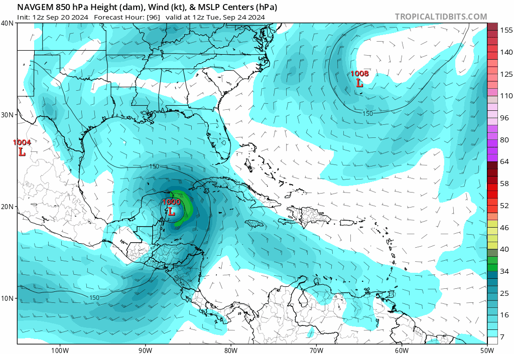
Re: Area of low pressure to develop over the western Caribbean sea (0/50)
12Z NAVGEM, think it is a bit too far to the left but yikes, CAT 4:
3 likes

Re: Area of low pressure to develop over the western Caribbean sea (0/50)
Can’t wait to see what the hurricane models do with it in a few days.
1 likes
Igor 2010, Sandy 2012, Fay 2014, Gonzalo 2014, Joaquin 2015, Nicole 2016, Humberto 2019, Imelda 2025
I am only a tropical weather enthusiast. My predictions are not official and may or may not be backed by sound meteorological data. For official information, please refer to the NHC and NWS products.
I am only a tropical weather enthusiast. My predictions are not official and may or may not be backed by sound meteorological data. For official information, please refer to the NHC and NWS products.
-
StPeteMike

- Category 2

- Posts: 656
- Joined: Thu Jun 07, 2018 11:26 pm
Re: Area of low pressure to develop over the western Caribbean sea (0/50)
LAF92 wrote:[url]https://i.postimg.cc/xCmdW8MT/IMG-1494.gif [/url]
12z Euro ensembles have come to life
So, either trough comes in and pulls it to the NE or ridge builds in and nudges it west until it can move N/NE.
I need Monday to get here so we can grasp what this thing will do better.
1 likes
The above post is not official and should not be used as such. It is the opinion of the poster and may or may not be backed by sound meteorological data. It is not endorsed by any professional institution or storm2k.org. For official information, please refer to the NHC and NWS products.
-
Stratton23
- Category 5
- Posts: 3563
- Joined: Fri Jul 21, 2023 10:59 pm
- Location: Katy, Tx
-
toad strangler

- S2K Supporter
- Posts: 4546
- Joined: Sun Jul 28, 2013 3:09 pm
- Location: Earth
- Contact:
Re: Area of low pressure to develop over the western Caribbean sea (0/50)
Stratton23 wrote:NOAA has a highlighted risk zone of heavy rain and high winds all the way from the florida panhandle to the middle texas coast, that tells me all i need to know lol, could be a very large system
That noted area extends halfway down the peninsula let alone the panhandle.
2 likes
My Weather Station
https://www.wunderground.com/dashboard/pws/KFLPORTS603
https://www.wunderground.com/dashboard/pws/KFLPORTS603
-
cheezyWXguy

- Category 5
- Posts: 6282
- Joined: Mon Feb 13, 2006 12:29 am
- Location: Dallas, TX
Re: Area of low pressure to develop over the western Caribbean sea (0/50)
gatorcane wrote:12Z NAVGEM, think it is a bit too far to the left but yikes, CAT 4:
https://i.postimg.cc/9fZ5278S/navgem-mslp-uv850-watl-fh96-180.gif
That might be the strongest storm I’ve ever seen the NAVGEM model. Good thing it’s terrible. On a similar note, a recent run of the Korean model has a cat5 a bit south of there. No idea if that model is any good but seems too extreme either way.
1 likes
-
Frank P
- S2K Supporter
- Posts: 2779
- Joined: Fri Aug 29, 2003 10:52 am
- Location: Biloxi Beach, Ms
- Contact:
Re: Area of low pressure to develop over the western Caribbean sea (0/50)
thanks Stratton what I was looking for...
0 likes
-
Frank P
- S2K Supporter
- Posts: 2779
- Joined: Fri Aug 29, 2003 10:52 am
- Location: Biloxi Beach, Ms
- Contact:
Re: Area of low pressure to develop over the western Caribbean sea (0/50)
cheezyWXguy wrote:gatorcane wrote:12Z NAVGEM, think it is a bit too far to the left but yikes, CAT 4:
https://i.postimg.cc/9fZ5278S/navgem-mslp-uv850-watl-fh96-180.gif
That might be the strongest storm I’ve ever seen the NAVGEM model. Good thing it’s terrible. On a similar note, a recent run of the Korean model has a cat5 a bit south of there. No idea if that model is any good but seems too extreme either way.
that is one big ole hurricane right there! surge would be close to Katrina levels if it comes in at the right direction and a slow mover.. you know those Navy guys tend to sip on some good stuff in the early afternoon... hopefully that the cast with this run.. cheers.
1 likes
-
mcheer23

- Professional-Met

- Posts: 441
- Age: 32
- Joined: Sun Jun 24, 2012 8:24 pm
- Location: Sugar Land, Texas
Re: Area of low pressure to develop over the western Caribbean sea (0/50)
cheezyWXguy wrote:gatorcane wrote:12Z NAVGEM, think it is a bit too far to the left but yikes, CAT 4:
https://i.postimg.cc/9fZ5278S/navgem-mslp-uv850-watl-fh96-180.gif
That might be the strongest storm I’ve ever seen the NAVGEM model. Good thing it’s terrible. On a similar note, a recent run of the Korean model has a cat5 a bit south of there. No idea if that model is any good but seems too extreme either way.
KMA has back to back Cat 5 runs.
3 likes
-
TallyTracker
- Category 2
- Posts: 787
- Joined: Thu Oct 11, 2018 2:46 pm
Re: Area of low pressure to develop over the western Caribbean sea (0/50)
LAF92 wrote:[url]https://i.postimg.cc/xCmdW8MT/IMG-1494.gif [/url]
12z Euro ensembles have come to life
The majority have a right hook at the end. There are a handful drifting west at the end of the run too. Generally cyclones this time of year have a right hook but some notable exceptions include 2020’s Delta and Zeta. The steering and conditions were WAY different than 2024 though.
1 likes
Fran '96, Georges '98, Gordon '00, Gabrielle '01, Charley '04, Frances '04, Jeanne '04, Barry '07, Fay '08, Debby '12, Matthew '16, Emily '17, Irma '17, Michael ‘18, Elsa ‘21, Fred ‘21, Mindy ‘21, Nicole ‘22, Idalia ‘23, Debby ‘24, Helene ‘24
-
DunedinDave
- Category 1

- Posts: 269
- Joined: Fri Aug 25, 2023 10:31 am
Re: Area of low pressure to develop over the western Caribbean sea (0/50)
I think it’s interesting to note with a lot of these ensembles we’re looking for landfall spots. But there’s a lot that stall it out in the Gulf as well that kind of gets lost in the shuffle. I do think a stall out is possible. We’ve seen it happen a lot this time of year. Opal got stuck there for a couple of days near the BOC just waiting for something to pick it up.
To me the stall out scenario is the worse case one because it can sit and blow up in the southern Gulf. That’s what the GFS early happy hour run did yesterday…the 12z one.
To me the stall out scenario is the worse case one because it can sit and blow up in the southern Gulf. That’s what the GFS early happy hour run did yesterday…the 12z one.
2 likes

Re: Area of low pressure to develop over the western Caribbean sea (0/50)
TallyTracker wrote:LAF92 wrote:[url]https://i.postimg.cc/xCmdW8MT/IMG-1494.gif [/url]
12z Euro ensembles have come to life
The majority have a right hook at the end. There are a handful drifting west at the end of the run too. Generally cyclones this time of year have a right hook but some notable exceptions include 2020’s Delta and Zeta. The steering and conditions were WAY different than 2024 though.
Not impossible, of course, but a late September landfall in Texas would be fairly rare. This season has been so whacky though, that I think all bets are off.
1 likes
Personal Forecast Disclaimer:
The posts in this forum are NOT official forecast and should not be used as such. They are just the opinion of the poster and may or may not be backed by sound meteorological data. They are NOT endorsed by any professional institution or storm2k.org. For official information, please refer to the NHC and NWS products.
The posts in this forum are NOT official forecast and should not be used as such. They are just the opinion of the poster and may or may not be backed by sound meteorological data. They are NOT endorsed by any professional institution or storm2k.org. For official information, please refer to the NHC and NWS products.
-
CourierPR

- Category 5
- Posts: 1336
- Age: 72
- Joined: Tue Aug 31, 2004 7:53 pm
- Location: Pompano Beach, Florida
Re: Area of low pressure to develop over the western Caribbean sea (0/50)
The latest satellite loop appears to show something forming in the SW Caribbean. If it comes together faster than forecast, would future track be affected?
1 likes
-
StPeteMike
- Category 2
- Posts: 656
- Joined: Thu Jun 07, 2018 11:26 pm
Re: Area of low pressure to develop over the western Caribbean sea (0/50)
CourierPR wrote:The latest satellite loop appears to show something forming in the SW Caribbean. If it comes together faster than forecast, would future track be affected?
It’s the precursor to the eventual system. This should give the future Helene (yes, think this will take the H name) plenty of juice to tap into. I would not be surprised if it forms a little earlier than some of the models have it consolidating.
1 likes
The above post is not official and should not be used as such. It is the opinion of the poster and may or may not be backed by sound meteorological data. It is not endorsed by any professional institution or storm2k.org. For official information, please refer to the NHC and NWS products.

Re: Area of low pressure to develop over the western Caribbean sea (0/50)
cheezyWXguy wrote:gatorcane wrote:12Z NAVGEM, think it is a bit too far to the left but yikes, CAT 4:
https://i.postimg.cc/9fZ5278S/navgem-mslp-uv850-watl-fh96-180.gif
That might be the strongest storm I’ve ever seen the NAVGEM model. Good thing it’s terrible. On a similar note, a recent run of the Korean model has a cat5 a bit south of there. No idea if that model is any good but seems too extreme either way.
I don’t know anything about the KMA but when NAVGEM and CMC are teamed up vs the big 3, I got some doubts. Their solutions are not unreasonable. If you run them at 500 it comes down to a cutoff upper low and its influence on the system coming up.
NAVGEM cuts that low off back in Arizona and keeps it in the 4 corner states. 150 hours
https://www.tropicaltidbits.com/analysi ... 012&fh=150
Canadian has it in the Great Plains
https://www.tropicaltidbits.com/analysi ... 012&fh=150
GFS has it at the MO/IA border
https://www.tropicaltidbits.com/analysi ... 012&fh=150
ICON has it in southern Missouri
https://www.tropicaltidbits.com/analysi ... 012&fh=150
EC 6z has a different setup with a negatively tilted trough reaching down from the eastern Great Lakes.
https://www.tropicaltidbits.com/analysi ... 006&fh=156
Last edited by Steve on Fri Sep 20, 2024 3:09 pm, edited 1 time in total.
2 likes
-
Frank P
- S2K Supporter
- Posts: 2779
- Joined: Fri Aug 29, 2003 10:52 am
- Location: Biloxi Beach, Ms
- Contact:
Re: Area of low pressure to develop over the western Caribbean sea (0/50)
mcheer23 wrote:cheezyWXguy wrote:gatorcane wrote:12Z NAVGEM, think it is a bit too far to the left but yikes, CAT 4:
https://i.postimg.cc/9fZ5278S/navgem-mslp-uv850-watl-fh96-180.gif
That might be the strongest storm I’ve ever seen the NAVGEM model. Good thing it’s terrible. On a similar note, a recent run of the Korean model has a cat5 a bit south of there. No idea if that model is any good but seems too extreme either way.
KMA has back to back Cat 5 runs.
I have searched the web for the KMA to no avail, do you have a link please? thanks
0 likes