that pattern may wipe out the MDR in terms of development. May be a technical niña, but look at the very warm waters in the tropical EPAC. I wonder if that was the 1983 pattern
2015 indicators: Instability / SST's / MSLP / Steering / Sal
Moderator: S2k Moderators
Forum rules

The posts in this forum are NOT official forecasts and should not be used as such. They are just the opinion of the poster and may or may not be backed by sound meteorological data. They are NOT endorsed by any professional institution or STORM2K. For official information, please refer to products from the National Hurricane Center and National Weather Service.
-
ninel conde
-
ninel conde
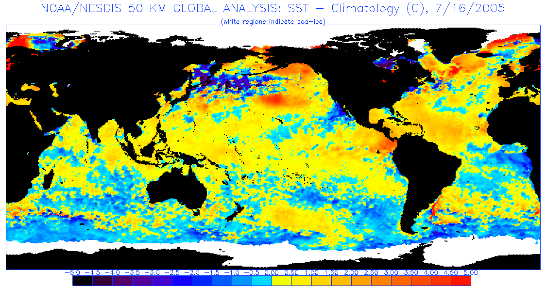
this is the july 2005 sst's. very similar to what is predicted for july 2016
http://www.ospo.noaa.gov/data/sst/anoma ... 6.2005.gif
http://www.ospo.noaa.gov/data/sst/anoma ... 6.2005.gif
0 likes
Bastardi is hyping at this point. I mean, how can he not notice the very warm tropical EPAC? It was the first thing I saw on that plot. There is going to be a lot of far EPAC convection if that plays out because that is where the warm waters are in the EPAC. That can only lead to very strong shear in the Caribbean, maybe even worse than this year (talking 1983 levels)
0 likes
-
ninel conde
Re:
Alyono wrote:Bastardi is hyping at this point. I mean, how can he not notice the very warm tropical EPAC? It was the first thing I saw on that plot. There is going to be a lot of far EPAC convection if that plays out because that is where the warm waters are in the EPAC. That can only lead to very strong shear in the Caribbean, maybe even worse than this year (talking 1983 levels)
True, but july 2016 looks very similar to july 2005.
0 likes
Re: Re:
ninel conde wrote:Alyono wrote:Bastardi is hyping at this point. I mean, how can he not notice the very warm tropical EPAC? It was the first thing I saw on that plot. There is going to be a lot of far EPAC convection if that plays out because that is where the warm waters are in the EPAC. That can only lead to very strong shear in the Caribbean, maybe even worse than this year (talking 1983 levels)
True, but july 2016 looks very similar to july 2005.
In the Atlantic, yes. However, there is far more than warm SSTs needed. Will not matter if the EPAC is producing 100 kts of shear across the Caribbean
0 likes
-
ninel conde
-
ninel conde
-
Yellow Evan

- Professional-Met

- Posts: 16232
- Age: 27
- Joined: Fri Jul 15, 2011 12:48 pm
- Location: Henderson, Nevada/Honolulu, HI
- Contact:
Re: Re:
Alyono wrote:ninel conde wrote:Alyono wrote:Bastardi is hyping at this point. I mean, how can he not notice the very warm tropical EPAC? It was the first thing I saw on that plot. There is going to be a lot of far EPAC convection if that plays out because that is where the warm waters are in the EPAC. That can only lead to very strong shear in the Caribbean, maybe even worse than this year (talking 1983 levels)
True, but july 2016 looks very similar to july 2005.
In the Atlantic, yes. However, there is far more than warm SSTs needed. Will not matter if the EPAC is producing 100 kts of shear across the Caribbean
The EPAC looks a lot cooler in July 2016 than July 2015 on the CFS run. Which would mean less Caribbean shear.
0 likes

Re: Re:
Alyono wrote:ninel conde wrote:Alyono wrote:Bastardi is hyping at this point. I mean, how can he not notice the very warm tropical EPAC? It was the first thing I saw on that plot. There is going to be a lot of far EPAC convection if that plays out because that is where the warm waters are in the EPAC. That can only lead to very strong shear in the Caribbean, maybe even worse than this year (talking 1983 levels)
True, but july 2016 looks very similar to july 2005.
In the Atlantic, yes. However, there is far more than warm SSTs needed. Will not matter if the EPAC is producing 100 kts of shear across the Caribbean
Would this spell a fourth consecutive below average season if that's the case?
0 likes
The above post is not official and should not be used as such. It is the opinion of the poster and may or may not be backed by sound meteorological data. It is not endorsed by any professional institution or storm2k.org. For official information, please refer to the NHC and NWS products.

Re: 2015 indicators: Instability / SST's / MSLP / Steering / Sal
I really doubt windshear will be an issue over the Caribbean next year if ENSO goes into at least a cool neutral state by next summer.
0 likes
Re: 2015 indicators: Instability / SST's / MSLP / Steering / Sal
Now that I looked at 1983, Alyono has a point, ENSO did cooled down some in the central Pacific by the heart of the Atlantic's hurricane season but it stayed very warm over the eastern equatorial Pacific, it did not go into a true La Nina state until late 1984.
If next year ENSO 1+2 and parts of Nino 3 stay warm like it did in 1983 wind shear could stay up across the Caribbean.
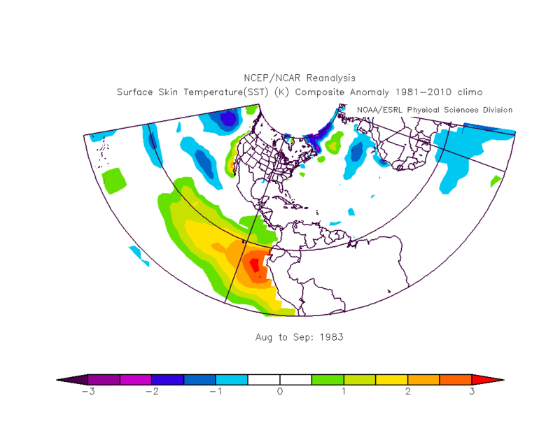
If next year ENSO 1+2 and parts of Nino 3 stay warm like it did in 1983 wind shear could stay up across the Caribbean.
0 likes
-
Andrew92

- S2K Supporter

- Posts: 3247
- Age: 42
- Joined: Mon Jun 16, 2003 12:35 am
- Location: Phoenix, Arizona
I'd also be interested in 1959 and 1973. Like 1983, these years fell in the first year after an El Nino, but had no hurricanes in the Caribbean. Additionally, those two years had no Gulf major hurricanes, though 1983 had Alicia. All of these years came off of strong El Nino events, like this year's event (though 1958 was admittedly weaker than 1957).
You could even lump 2003 as an analog of interest if we go that route. Only Claudette was very briefly a (very disorganized) hurricane for a couple hours in the Caribbean that year, with no Gulf majors. But I think 2002 was a moderate event, though it might have had strong warm anomalies in the Central Pacific, almost like a Modoki but also with some warm anomalies in the eastern part that just weren't as pronounced.
-Andrew92
0 likes
-
Andrew92
- S2K Supporter
- Posts: 3247
- Age: 42
- Joined: Mon Jun 16, 2003 12:35 am
- Location: Phoenix, Arizona
Well, I did just look at SST anomalies in the Pacific in the August-September periods in 1959, 1973, 1983, and 2003.
1983 very much looked like a dying but still going on El Nino. That could have very easily played a role in the Caribbean being so unfavorable that year for hurricanes. 1959 showed a strong La Nina at and near the Equator all through the Pacific, but there was a very noticeable pool of warm anomalies from Baja California extending southwest, with even some weak warm anomalies right off Central America. 2003 had almost all warm anomalies, but mostly weak with one maybe moderate spot southwest of Baja California.
So perhaps some warm anomalies in the tropical Pacific were able to keep the Caribbean at bay in 1959, 1983, and 2003. But I would have to find another explanation for 1973, as La Nina was in full force by the peak of that season. All cold anomalies in the Eastern Pacific, mostly quite strong. Nothing warm.
-Andrew92
0 likes
-
Andrew92
- S2K Supporter
- Posts: 3247
- Age: 42
- Joined: Mon Jun 16, 2003 12:35 am
- Location: Phoenix, Arizona
You know, after reviewing all the previous posts, I also took a look at July 2005. The warm anomalies in the Eastern Pacific that year were in pockets and weak, and even mixed in with some cool anomalies as well. The warm anomalies at about the time of the graphic above were nothing like that of August-September 1983.
The 2016 forecast SST anomaly link is much more in line with something like a mix of 1959 and 1983, in my opinion. Like Alyono said, that could make for a quiet Caribbean next year.
-Andrew92
The 2016 forecast SST anomaly link is much more in line with something like a mix of 1959 and 1983, in my opinion. Like Alyono said, that could make for a quiet Caribbean next year.
-Andrew92
0 likes
Re:
Andrew92 wrote:You know, after reviewing all the previous posts, I also took a look at July 2005. The warm anomalies in the Eastern Pacific that year were in pockets and weak, and even mixed in with some cool anomalies as well. The warm anomalies at about the time of the graphic above were nothing like that of August-September 1983.
The 2016 forecast SST anomaly link is much more in line with something like a mix of 1959 and 1983, in my opinion. Like Alyono said, that could make for a quiet Caribbean next year.
-Andrew92
Not only that, but with the warm waters centered well east of where they were this year, the entire MDR could be out of play IF the Pacific SST pattern as predicted by the CFS verifies. The record warm waters won't matter as we'll have 50+ kts of shear
That Pacific SST pattern verifies and we will have 5 storms max next year
0 likes
-
Hurricaneman

- Category 5

- Posts: 7404
- Age: 45
- Joined: Tue Aug 31, 2004 3:24 pm
- Location: central florida
Re: Re:
Alyono wrote:Andrew92 wrote:You know, after reviewing all the previous posts, I also took a look at July 2005. The warm anomalies in the Eastern Pacific that year were in pockets and weak, and even mixed in with some cool anomalies as well. The warm anomalies at about the time of the graphic above were nothing like that of August-September 1983.
The 2016 forecast SST anomaly link is much more in line with something like a mix of 1959 and 1983, in my opinion. Like Alyono said, that could make for a quiet Caribbean next year.
-Andrew92
Not only that, but with the warm waters centered well east of where they were this year, the entire MDR could be out of play IF the Pacific SST pattern as predicted by the CFS verifies. The record warm waters won't matter as we'll have 50+ kts of shear
That Pacific SST pattern verifies and we will have 5 storms max next year
I think we'll know by April what type of pattern the 2016 hurricane season will be and for those that thought that 1998 didn't have a warm 1-2 it did and caused the season to start mid to late august but that warm switched to cool for September on then became memorable so wwho really knows at this point
The posts in this forum are NOT official forecast and should not be used as such. They are just the opinion of the poster and may or may not be backed by sound meteorological data. They are NOT endorsed by any professional institution or storm2k.org. For official information, please refer to the NHC and NWS products
0 likes
-
Andrew92
- S2K Supporter
- Posts: 3247
- Age: 42
- Joined: Mon Jun 16, 2003 12:35 am
- Location: Phoenix, Arizona
Re: Re:
Alyono wrote:Andrew92 wrote:You know, after reviewing all the previous posts, I also took a look at July 2005. The warm anomalies in the Eastern Pacific that year were in pockets and weak, and even mixed in with some cool anomalies as well. The warm anomalies at about the time of the graphic above were nothing like that of August-September 1983.
The 2016 forecast SST anomaly link is much more in line with something like a mix of 1959 and 1983, in my opinion. Like Alyono said, that could make for a quiet Caribbean next year.
-Andrew92
Not only that, but with the warm waters centered well east of where they were this year, the entire MDR could be out of play IF the Pacific SST pattern as predicted by the CFS verifies. The record warm waters won't matter as we'll have 50+ kts of shear
That Pacific SST pattern verifies and we will have 5 storms max next year
Unless we get lots of frontal-low or subtropical storms. If Sandy Delgado/HURAKAN's master thesis holds up, that was the case in 1959.
Even though nothing is actually official from that thesis, I do have the best tracks from the seasons he put together saved in my Tracking the Eye. According to his thesis, the Caribbean was even more dead than initially thought. Edith, the only storm to reach there, may have dissipated even earlier than though and may have been weaker and shorter-lived. The only other tropical storm that year maybe in the Caribbean was Judith, very borderline since it formed right at about the Yucatan Channel.
Also of note in 1959 according to his thesis is that the one previously-known unnamed storm that reached Canada as a powerful extratropical cyclone and Cindy are no longer hurricanes, if his analysis stands. This would mean only 5 hurricanes that year. He did find three more unnamed storms that year though, upping the total number of tropical storms to 14.
For those who haven't seen his thesis, you can check it out here (be forewarned, it is a large file with 841 pages): http://www.aoml.noaa.gov/hrd/Landsea/Sa ... Thesis.pdf
(Also keep in mind, 1954 and 1955 re-analysis is officially complete, so consider that when reading his thesis.)
I wouldn't rule 1959 out as a possible analog for next year in the least, along with 1983. And keep in mind, those years still each had a major reach the United States. Gracie and Alicia, respectively.
-Andrew92
0 likes
Regarding the Pacific temperatures, if everything is favorable otherwise yet we have too much shear due to Nino-esque effects and end up having a quiet season as a result, that'll further delay knowing whether or not the active period is still going on top of it.
0 likes
The above post is not official and should not be used as such. It is the opinion of the poster and may or may not be backed by sound meteorological data. It is not endorsed by any professional institution or storm2k.org. For official information, please refer to the NHC and NWS products.
-
Andrew92
- S2K Supporter
- Posts: 3247
- Age: 42
- Joined: Mon Jun 16, 2003 12:35 am
- Location: Phoenix, Arizona
Re: Re:
Hurricaneman wrote:Alyono wrote:Andrew92 wrote:You know, after reviewing all the previous posts, I also took a look at July 2005. The warm anomalies in the Eastern Pacific that year were in pockets and weak, and even mixed in with some cool anomalies as well. The warm anomalies at about the time of the graphic above were nothing like that of August-September 1983.
The 2016 forecast SST anomaly link is much more in line with something like a mix of 1959 and 1983, in my opinion. Like Alyono said, that could make for a quiet Caribbean next year.
-Andrew92
Not only that, but with the warm waters centered well east of where they were this year, the entire MDR could be out of play IF the Pacific SST pattern as predicted by the CFS verifies. The record warm waters won't matter as we'll have 50+ kts of shear
That Pacific SST pattern verifies and we will have 5 storms max next year
I think we'll know by April what type of pattern the 2016 hurricane season will be and for those that thought that 1998 didn't have a warm 1-2 it did and caused the season to start mid to late august but that warm switched to cool for September on then became memorable so wwho really knows at this point
The posts in this forum are NOT official forecast and should not be used as such. They are just the opinion of the poster and may or may not be backed by sound meteorological data. They are NOT endorsed by any professional institution or storm2k.org. For official information, please refer to the NHC and NWS products
1998 was indeed an interesting hurricane season. Started active in the EPAC and nearly dead in the Atlantic, and then the switch nearly completely flipped close to the peak. I just reviewed August-September SST anomalies, and I see the warmish trend, probably from leftovers coming into August. I will say that the warm anomalies do look stronger from the Equator to Central America than August-September 1959. However, the warm pool going from Baja California southwest isn't nearly as strong as 1959's. And the warm anomalies in the Eastern Pacific were still stronger in August-September 1983 than August-September 1998.
-Andrew92
0 likes
Who is online
Users browsing this forum: Hurricane2022, jconsor, ljmac75 and 349 guests