2019 Tropics: Global Model Runs Discussion (Out to day 16)

This is the general tropical discussion area. Anyone can take their shot at predicting a storms path.

Moderator: S2k Moderators

Forum rules

The posts in this forum are NOT official forecasts and should not be used as such. They are just the opinion of the poster and may or may not be backed by sound meteorological data. They are NOT endorsed by any professional institution or STORM2K. For official information, please refer to products from the National Hurricane Center and National Weather Service.

Help Support Storm2K
Message
Author
User avatar
StormLogic
Tropical Storm
Tropical Storm
Posts: 201
Joined: Mon Jun 03, 2019 9:58 am
Location: Beaumont

Re: 2019 Tropics: Global Model Runs Discussion (Out to day 16)

#641 Postby StormLogic » Tue Aug 27, 2019 12:18 pm

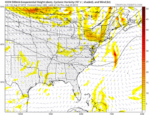
SoupBone wrote:Anyone else see the system being sent into the Louisiana/Texas area at the ICONs 06Z run.


Image

can be seen 120 out now, is this a telegram from our good friend dorian? will it make its way into the gom? im getting a bad feeling about this one.
0 likes   
Personal Forecast Disclaimer:
The posts in this forum are NOT official forecast and should not be used as such. They are just the opinion of the poster and may or may not be backed by sound meteorological data. They are NOT endorsed by any professional institution or storm2k.org. For official information, please refer to the NHC and NWS products.

User avatar
StormLogic
Tropical Storm
Tropical Storm
Posts: 201
Joined: Mon Jun 03, 2019 9:58 am
Location: Beaumont

Re: 2019 Tropics: Global Model Runs Discussion (Out to day 16)

#642 Postby StormLogic » Tue Aug 27, 2019 12:19 pm

Image
12z 180hr out, if you watch it play out, track almost resembles Rita 05'
0 likes   
Personal Forecast Disclaimer:
The posts in this forum are NOT official forecast and should not be used as such. They are just the opinion of the poster and may or may not be backed by sound meteorological data. They are NOT endorsed by any professional institution or storm2k.org. For official information, please refer to the NHC and NWS products.

User avatar
StormLogic
Tropical Storm
Tropical Storm
Posts: 201
Joined: Mon Jun 03, 2019 9:58 am
Location: Beaumont

Re: 2019 Tropics: Global Model Runs Discussion (Out to day 16)

#643 Postby StormLogic » Tue Aug 27, 2019 12:21 pm

cmc also onto some GOM anomalies
0 likes   
Personal Forecast Disclaimer:
The posts in this forum are NOT official forecast and should not be used as such. They are just the opinion of the poster and may or may not be backed by sound meteorological data. They are NOT endorsed by any professional institution or storm2k.org. For official information, please refer to the NHC and NWS products.

User avatar
StormLogic
Tropical Storm
Tropical Storm
Posts: 201
Joined: Mon Jun 03, 2019 9:58 am
Location: Beaumont

Re: 2019 Tropics: Global Model Runs Discussion (Out to day 16)

#644 Postby StormLogic » Tue Aug 27, 2019 12:22 pm

Image
NAVGEM onto GOM anomaly
0 likes   
Personal Forecast Disclaimer:
The posts in this forum are NOT official forecast and should not be used as such. They are just the opinion of the poster and may or may not be backed by sound meteorological data. They are NOT endorsed by any professional institution or storm2k.org. For official information, please refer to the NHC and NWS products.

User avatar
StormLogic
Tropical Storm
Tropical Storm
Posts: 201
Joined: Mon Jun 03, 2019 9:58 am
Location: Beaumont

Re: 2019 Tropics: Global Model Runs Discussion (Out to day 16)

#645 Postby StormLogic » Tue Aug 27, 2019 12:28 pm

Image
icon 12z
1 likes   
Personal Forecast Disclaimer:
The posts in this forum are NOT official forecast and should not be used as such. They are just the opinion of the poster and may or may not be backed by sound meteorological data. They are NOT endorsed by any professional institution or storm2k.org. For official information, please refer to the NHC and NWS products.

User avatar
SEASON_CANCELED
Category 3
Category 3
Posts: 887
Joined: Mon Jul 06, 2009 5:17 am
Location: 8 Bit Charlie Sheen

Re: 2019 Tropics: Global Model Runs Discussion (Out to day 16)

#646 Postby SEASON_CANCELED » Tue Aug 27, 2019 4:19 pm

Never liked icon

Looks like a 1 - 2 punch for texas

A second storm
0 likes   
i am a big stupid ugly moron with an ugly face and a big butt and my butt stinks and i like to kiss my own butt

USTropics
Category 5
Category 5
Posts: 2422
Joined: Sun Aug 12, 2007 3:45 am
Location: Florida State University

Re: 2019 Tropics: Global Model Runs Discussion (Out to day 16)

#647 Postby USTropics » Wed Aug 28, 2019 5:50 am

00z ECMWF hinting at an active MDR, with a potential long tracking, classic CV system:

Image
3 likes   

User avatar
DioBrando
Category 4
Category 4
Posts: 917
Age: 27
Joined: Sun Aug 12, 2018 12:45 pm

Re: 2019 Tropics: Global Model Runs Discussion (Out to day 16)

#648 Postby DioBrando » Wed Aug 28, 2019 6:56 am

USTropics wrote:00z ECMWF hinting at an active MDR, with a potential long tracking, classic CV system:

https://i.imgur.com/AJk5ZEY.png

And that east coast system is dorian?
0 likes   
blonde stacey (xe/xem/xir)

USTropics
Category 5
Category 5
Posts: 2422
Joined: Sun Aug 12, 2007 3:45 am
Location: Florida State University

Re: 2019 Tropics: Global Model Runs Discussion (Out to day 16)

#649 Postby USTropics » Wed Aug 28, 2019 6:59 am

DioBrando wrote:
USTropics wrote:00z ECMWF hinting at an active MDR, with a potential long tracking, classic CV system:

https://i.imgur.com/AJk5ZEY.png

And that east coast system is dorian?


Yes, Dorian essentially does a cyclonic loop over FL and ejects off the EC:
Image
2 likes   

User avatar
DioBrando
Category 4
Category 4
Posts: 917
Age: 27
Joined: Sun Aug 12, 2018 12:45 pm

Re: 2019 Tropics: Global Model Runs Discussion (Out to day 16)

#650 Postby DioBrando » Wed Aug 28, 2019 7:15 am

USTropics wrote:
DioBrando wrote:
USTropics wrote:00z ECMWF hinting at an active MDR, with a potential long tracking, classic CV system:

https://i.imgur.com/AJk5ZEY.png

And that east coast system is dorian?


Yes, Dorian essentially does a cyclonic loop over FL and ejects off the EC:
https://i.ibb.co/nCXsvD2/ecmwf-z500-mslp-us-fh96-240.gif

And what name does this model long tracker have?
0 likes   
blonde stacey (xe/xem/xir)

User avatar
AnnularCane
S2K Supporter
S2K Supporter
Posts: 2658
Joined: Thu Jun 08, 2006 9:18 am
Location: Wytheville, VA

Re: 2019 Tropics: Global Model Runs Discussion (Out to day 16)

#651 Postby AnnularCane » Wed Aug 28, 2019 10:09 am

DioBrando wrote:
USTropics wrote:
DioBrando wrote:And that east coast system is dorian?


Yes, Dorian essentially does a cyclonic loop over FL and ejects off the EC:
https://i.ibb.co/nCXsvD2/ecmwf-z500-mslp-us-fh96-240.gif

And what name does this model long tracker have?


I think that will remain to be seen. 8-)
0 likes   

User avatar
SEASON_CANCELED
Category 3
Category 3
Posts: 887
Joined: Mon Jul 06, 2009 5:17 am
Location: 8 Bit Charlie Sheen

Re: 2019 Tropics: Global Model Runs Discussion (Out to day 16)

#652 Postby SEASON_CANCELED » Wed Aug 28, 2019 10:51 am

USTropics wrote:
DioBrando wrote:
USTropics wrote:00z ECMWF hinting at an active MDR, with a potential long tracking, classic CV system:

https://i.imgur.com/AJk5ZEY.png

And that east coast system is dorian?


Yes, Dorian essentially does a cyclonic loop over FL and ejects off the EC:
https://i.ibb.co/nCXsvD2/ecmwf-z500-mslp-us-fh96-240.gif


Thats crap

Tampa Area doesn't need this.
0 likes   
i am a big stupid ugly moron with an ugly face and a big butt and my butt stinks and i like to kiss my own butt

User avatar
Hammy
Category 5
Category 5
Posts: 5595
Age: 40
Joined: Fri May 25, 2012 5:25 pm
Contact:

Re: 2019 Tropics: Global Model Runs Discussion (Out to day 16)

#653 Postby Hammy » Wed Aug 28, 2019 2:11 pm

Euro says no to Cape Verde cyclone train this run as it's back to the higher-latitude waves. Still quite a bit stronger than the last few afternoon runs. CFS has been saying between Sep 4 and 8 for the actual Cape Verde season to wake up so that's about on par either way.
0 likes   
The above post is not official and should not be used as such. It is the opinion of the poster and may or may not be backed by sound meteorological data. It is not endorsed by any professional institution or storm2k.org. For official information, please refer to the NHC and NWS products.

User avatar
captainbarbossa19
Category 5
Category 5
Posts: 1040
Joined: Wed Aug 21, 2019 11:09 pm
Location: Starkville, MS

Re: 2019 Tropics: Global Model Runs Discussion (Out to day 16)

#654 Postby captainbarbossa19 » Wed Aug 28, 2019 8:37 pm

Hammy wrote:Euro says no to Cape Verde cyclone train this run as it's back to the higher-latitude waves. Still quite a bit stronger than the last few afternoon runs. CFS has been saying between Sep 4 and 8 for the actual Cape Verde season to wake up so that's about on par either way.


Image

This was the Euro's forecast for yesterday evening's conditions. The forecast was made last Thursday. There is not even a small sign of Dorian on this map. While model runs can be helpful in the short-range, this is a perfect example of why one model run should never be trusted (especially long-range). I am not sure whether or not we will have an increase in activity soon, but it is clear that conditions can quickly change and models often cannot detect these changes.
2 likes   

User avatar
Hammy
Category 5
Category 5
Posts: 5595
Age: 40
Joined: Fri May 25, 2012 5:25 pm
Contact:

Re: 2019 Tropics: Global Model Runs Discussion (Out to day 16)

#655 Postby Hammy » Thu Aug 29, 2019 1:28 am

captainbarbossa19 wrote:
Hammy wrote:Euro says no to Cape Verde cyclone train this run as it's back to the higher-latitude waves. Still quite a bit stronger than the last few afternoon runs. CFS has been saying between Sep 4 and 8 for the actual Cape Verde season to wake up so that's about on par either way.


https://i.imgur.com/yT7i4QM.png

This was the Euro's forecast for yesterday evening's conditions. The forecast was made last Thursday. There is not even a small sign of Dorian on this map. While model runs can be helpful in the short-range, this is a perfect example of why one model run should never be trusted (especially long-range). I am not sure whether or not we will have an increase in activity soon, but it is clear that conditions can quickly change and models often cannot detect these changes.


I don't disagree, just posting what that particular run was saying. I've been pretty much expecting by the end of the first week of September that we'd start getting into the more active wave train for some time as the longer range signals have been very consistent on this, even if at various strong and weak intensities.
1 likes   
The above post is not official and should not be used as such. It is the opinion of the poster and may or may not be backed by sound meteorological data. It is not endorsed by any professional institution or storm2k.org. For official information, please refer to the NHC and NWS products.

User avatar
Kazmit
Category 5
Category 5
Posts: 1915
Age: 21
Joined: Mon Jul 25, 2016 8:49 am
Location: Williamsburg VA for college, Bermuda otherwise

Re: 2019 Tropics: Global Model Runs Discussion (Out to day 16)

#656 Postby Kazmit » Thu Aug 29, 2019 7:59 am

The Euro and the GFS are both showing some MDR mischief later next week.
0 likes   
Igor 2010, Sandy 2012, Fay 2014, Gonzalo 2014, Joaquin 2015, Nicole 2016, Humberto 2019

I am only a tropical weather enthusiast. My predictions are not official and may or may not be backed by sound meteorological data. For official information, please refer to the NHC and NWS products.

User avatar
South Texas Storms
Professional-Met
Professional-Met
Posts: 4040
Joined: Thu Jun 24, 2010 12:28 am
Location: Houston, TX

Re: 2019 Tropics: Global Model Runs Discussion (Out to day 16)

#657 Postby South Texas Storms » Thu Aug 29, 2019 11:58 am

Canadian and ICON have been showing a possible brief spin up in the western Gulf during the first half of next week. At a minimum it looks like a disturbance will form in the Gulf this weekend and then head westward most likely towards northern Mexico. Hopefully it can at least bring some rain and heat relief to south TX.
3 likes   

User avatar
StPeteMike
Category 1
Category 1
Posts: 389
Joined: Thu Jun 07, 2018 11:26 pm

Re: 2019 Tropics: Global Model Runs Discussion (Out to day 16)

#658 Postby StPeteMike » Fri Aug 30, 2019 12:01 am

South Texas Storms wrote:Canadian and ICON have been showing a possible brief spin up in the western Gulf during the first half of next week. At a minimum it looks like a disturbance will form in the Gulf this weekend and then head westward most likely towards northern Mexico. Hopefully it can at least bring some rain and heat relief to south TX.

I believe this is the ULL that is just west of Dorian at the moment. The past few hours has seen the low start moving a little faster west. Then seems to enter the Gulf by late Friday, form a LLC, and become a lower end TS before cruising into the NoMe/Brownsville area.
1 likes   
The above post is not official and should not be used as such. It is the opinion of the poster and may or may not be backed by sound meteorological data. It is not endorsed by any professional institution or storm2k.org. For official information, please refer to the NHC and NWS products.

User avatar
Hypercane_Kyle
Category 5
Category 5
Posts: 2911
Joined: Sat Mar 07, 2015 7:58 pm
Location: Cape Canaveral, FL

Re: 2019 Tropics: Global Model Runs Discussion (Out to day 16)

#659 Postby Hypercane_Kyle » Fri Aug 30, 2019 1:12 am

12z ECMWF showed 1-2 hurricanes in the MDR.
0 likes   
My posts are my own personal opinion, defer to the National Hurricane Center (NHC) and other NOAA products for decision making during hurricane season.

User avatar
Hypercane_Kyle
Category 5
Category 5
Posts: 2911
Joined: Sat Mar 07, 2015 7:58 pm
Location: Cape Canaveral, FL

Re: 2019 Tropics: Global Model Runs Discussion (Out to day 16)

#660 Postby Hypercane_Kyle » Fri Aug 30, 2019 1:19 am

658
ABNT20 KNHC 300551
TWOAT

Tropical Weather Outlook
NWS National Hurricane Center Miami FL
200 AM EDT Fri Aug 30 2019

For the North Atlantic...Caribbean Sea and the Gulf of Mexico:

The National Hurricane Center is issuing advisories on Hurricane
Dorian, located a few hundred miles east-northeast of the
southeastern Bahamas.

A tropical wave is moving westward from the coast of Africa.
Some development of this system is possible early next week over
the eastern and central tropical Atlantic.
* Formation chance through 48 hours...low...near 0 percent.
* Formation chance through 5 days...low...20 percent.

$$
Forecaster Beven
1 likes   
My posts are my own personal opinion, defer to the National Hurricane Center (NHC) and other NOAA products for decision making during hurricane season.


Return to “Talkin' Tropics”

Who is online

Users browsing this forum: HurakaYoshi, HurricaneMaster_PR and 29 guests