Rita,Comments,Sat Pics,Models Thread
Moderator: S2k Moderators
Forum rules
The posts in this forum are NOT official forecasts and should not be used as such. They are just the opinion of the poster and may or may not be backed by sound meteorological data. They are NOT endorsed by any professional institution or STORM2K. For official information, please refer to products from the National Hurricane Center and National Weather Service.
ERC decoupling becoming more obvious in the moisture loop (not dry air).
http://www.ssd.noaa.gov/PS/TROP/DATA/RT ... -loop.html
http://www.ssd.noaa.gov/PS/TROP/DATA/RT ... -loop.html
Last edited by oneness on Thu Sep 22, 2005 10:12 pm, edited 1 time in total.
0 likes
cjrciadt wrote:
Latest pic
dwg
i take it you are talking about this image?
nevermind, it is an updating image so it is useless now
Last edited by CronkPSU on Thu Sep 22, 2005 10:45 pm, edited 1 time in total.
0 likes
- deltadog03
- Professional-Met

- Posts: 3580
- Joined: Tue Jul 05, 2005 6:16 pm
- Location: Macon, GA
dwg
hey, my wife just gave birth yesterday to our second child(that is a GREAT distraction compared to Rita) so I may have some trouble enjoying the NW/PSU game as well
i hope you are right and some dry air/shear/another ERC (not likely) and/or some colder waters (just before landfall) break this bad girl down so i can watch these games and the newborn without worrying about another katrina tragedy
0 likes
-
superfly
-
curtadams
- S2K Supporter

- Posts: 1122
- Joined: Sun Aug 28, 2005 7:57 pm
- Location: Orange, California
- Contact:
3:15 image Rita is starting to look disturbingly perfect - big round eye surrounded by a very thick but compact eyewall. http://www.ssd.noaa.gov/PS/TROP/DATA/RT ... IR4/20.jpg Not as pretty as the usual spiralling and much more ominous. Now for 3 hours I wonder whether it's illusion or whether something historical is happening. I hate blackout.
0 likes
curtadams wrote:3:15 image Rita is starting to look disturbingly perfect - big round eye surrounded by a very thick but compact eyewall. http://www.ssd.noaa.gov/PS/TROP/DATA/RT ... IR4/20.jpg Not as pretty as the usual spiralling and much more ominous. Now for 3 hours I wonder whether it's illusion or whether something historical is happening. I hate blackout.
Im getting a little alarmed myself, suddenly a bit higher cloud tops blowing up FAR from the old eye. Hopefully cooler water temps will keep things from getting out of hand.........
0 likes
-
joe_koehle
- Tropical Depression

- Posts: 61
- Joined: Wed Aug 24, 2005 10:26 pm
- Eyes2theSkies
- Category 1

- Posts: 264
- Joined: Thu Aug 12, 2004 4:20 am
- Location: Was Florida now Charlotte, NC
- Contact:

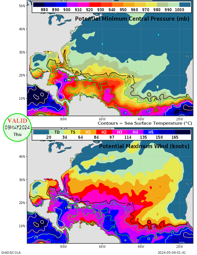
I'm not sure how accurate this picture is, but it looks like the ERC that has just completed came at a bad time. Rita is just now crossing 90W (at around 26N) -- you can see from that graph that the pressure simply had to rise above 910mb. But as we go into tomorrow, Rita will be moving into an area that can support pressures below 900mb (and cat-5 winds -- in fact, the area between Galveston Bay and TX/LA border could support winds of over 160 knots, and by that graph it's the only area in the Gulf that can support that). Seeing that Rita is now about 36 hours from landfall, is it possible that there will be no more ERCs before landfall, and that Rita could re-strengthen through the areas in dark blue and be at a secondary peak (i.e., not 897mb, but maybe closer to 910mb) at landfall?
0 likes
Who is online
Users browsing this forum: No registered users and 106 guests


