ENSO Updates (2007 thru 2023)

This is the general tropical discussion area. Anyone can take their shot at predicting a storms path.

Moderator: S2k Moderators

Forum rules

The posts in this forum are NOT official forecasts and should not be used as such. They are just the opinion of the poster and may or may not be backed by sound meteorological data. They are NOT endorsed by any professional institution or STORM2K. For official information, please refer to products from the National Hurricane Center and National Weather Service.

Help Support Storm2K
Message
Author
HURRICANELONNY
Category 5
Category 5
Posts: 1383
Joined: Wed May 07, 2003 6:48 am
Location: HOLLYWOOD.FL

Re:

#6561 Postby HURRICANELONNY » Wed Sep 16, 2015 7:33 pm

Ntxw wrote:Mike Ventrice on twitter posted this

Image

And today it's been raining in NorCal. Can anyone say El Nino?

Amen!
0 likes   
hurricanelonny

dexterlabio
Category 5
Category 5
Posts: 3470
Joined: Sat Oct 24, 2009 11:50 pm

Re: ENSO: CPC update at 9/14/15: Nino 3.4 at +2.3C

#6562 Postby dexterlabio » Thu Sep 17, 2015 2:22 am

Ntxw wrote:Mike Ventrice on twitter posted this

Image

And today it's been raining in NorCal. Can anyone say El Nino?


I hope this is the beginning of the end of the horrid drought. Hopefully the northern part of CA will get more rain too.
0 likes   
Personal Forecast Disclaimer:
The posts in this forum are NOT official forecast and should not be used as such. They are just the opinion of the poster and may or may not be backed by sound meteorological data. They are NOT endorsed by any professional institution or storm2k.org. For official information, please refer to the NHC and NWS products.

User avatar
cycloneye
Admin
Admin
Posts: 145438
Age: 68
Joined: Thu Oct 10, 2002 10:54 am
Location: San Juan, Puerto Rico

Re: ENSO Updates= Mid-September plume of models is up

#6563 Postby cycloneye » Thu Sep 17, 2015 3:09 pm

The Mid-September plume of models have a peak of +2.4C at November,December and January.

http://iri.columbia.edu/our-expertise/c ... o/current/
0 likes   
Visit the Caribbean-Central America Weather Thread where you can find at first post web cams,radars
and observations from Caribbean basin members Click Here

User avatar
Hurricaneman
Category 5
Category 5
Posts: 7351
Age: 45
Joined: Tue Aug 31, 2004 3:24 pm
Location: central florida

Re: ENSO Updates= Mid-September plume of models is up

#6564 Postby Hurricaneman » Thu Sep 17, 2015 3:13 pm

cycloneye wrote:The Mid-September plume of models have a peak of +2.4C at November,December and January.

http://iri.columbia.edu/our-expertise/c ... o/current/


The plume models seem to pretty much say this El Nino has pretty much peaked and is going to maintain until January and substansially drop after that

The posts in this forum are NOT official forecast and should not be used as such. They are just the opinion of the poster and may or may not be backed by sound meteorological data. They are NOT endorsed by any professional institution or storm2k.org. For official information, please refer to the NHC and NWS products
0 likes   

User avatar
NDG
S2K Supporter
S2K Supporter
Posts: 15446
Joined: Sun Jul 09, 2006 10:14 pm
Location: Orlando, FL

Re: Re:

#6565 Postby NDG » Thu Sep 17, 2015 3:56 pm

CaliforniaResident wrote:
Ntxw wrote:While not direct, Los Angeles just had nearly 2 inches of rain today (Linda moisture) and with Dolores remnants earlier this summer it has been abnormally wet during the dry time of year for SoCal. Not many have been talking about.

Sept averages 0.27 inches of rain in Downtown LA. This however does not help much in terms of the water supply. What will be needed here is the mountain snows this winter.


Yep; Linda's heavy rains (extremely heavy by Southern California standards) caught everyone off guard since we were only expecting scattered showers. Havoc on the morning commute and people calling in sick and skipping classes due to fact that everyone "knows" how bad the traffic and roads are when we get the first rain of the fall.

More tropical moisture expected next week (remnants of the yet-to-form Marty?).

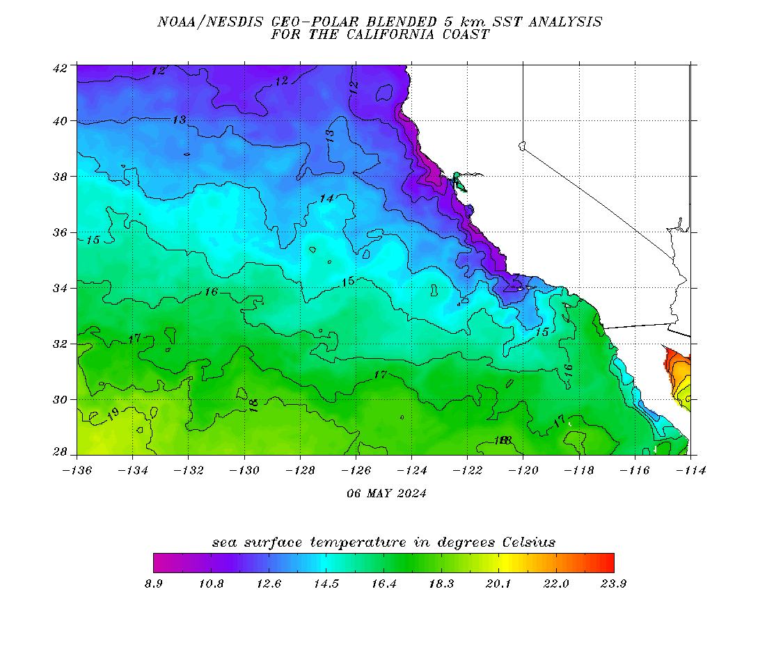
SST has also reached 26 C off of San Diego which is technically warm enough to sustain a hurricane should we get another strong EPAC storm that moves up off the coast of Baja.


Not really, Just because a surf beach might have reached 26 C it might have been very localized, offshore waters in southern Calif and northern Baja are in the the low to mid 70s, 26 deg C isotherm is way down closer to lower Baja Calif.

Image
Image
0 likes   

User avatar
WPBWeather
S2K Supporter
S2K Supporter
Posts: 535
Age: 67
Joined: Thu Jul 18, 2013 12:33 pm

Re: ENSO Updates= Mid-September plume of models is up

#6566 Postby WPBWeather » Thu Sep 17, 2015 4:45 pm

Hurricaneman wrote:
cycloneye wrote:The Mid-September plume of models have a peak of +2.4C at November,December and January.

http://iri.columbia.edu/our-expertise/c ... o/current/


The plume models seem to pretty much say this El Nino has pretty much peaked and is going to maintain until January and substansially drop after that

The posts in this forum are NOT official forecast and should not be used as such. They are just the opinion of the poster and may or may not be backed by sound meteorological data. They are NOT endorsed by any professional institution or storm2k.org. For official information, please refer to the NHC and NWS products


Yes, while this might be a strong El Nino, it is not super or Godzilla. Way too much hype by media and even Pro Mets that should know better.
0 likes   

User avatar
Ntxw
Storm2k Moderator
Storm2k Moderator
Posts: 22787
Joined: Wed Oct 21, 2009 6:34 pm
Location: DFW, Texas

Re: ENSO Updates= Mid-September plume of models is up

#6567 Postby Ntxw » Thu Sep 17, 2015 7:09 pm

cycloneye wrote:The Mid-September plume of models have a peak of +2.4C at November,December and January.

http://iri.columbia.edu/our-expertise/c ... o/current/


That seems pretty reasonable thus the weekly readings should peak around late October or November. Trimonthly the peak should favor OND or NDJ. Most guidance agrees with the line of thinking thus the El Nino will peak anywhere from third to first highest (second may be the best middle ground) at Nino 3.4. We'll have to see what ONI (ERSSTv4) does since it is hard to predict that dataset but all others will be 1 or 2. Peak will be sometime late fall or early winter and weakening should occur late winter into next spring. If it does achieve a trimonthly of 2.4C then it would be the strongest El Nino on record.

Remember a trimonthly is an average of three months. So NDJ does not mean peak in November, it means all three months averaged, it could be any of the three months or even all three. It has it ending around MJJ thus the average of the 3 months thus the likely end of the event will be sometime early to mid summer of next year per the IRI in May-June-July period.
0 likes   
The above post and any post by Ntxw is NOT an official forecast and should not be used as such. It is just the opinion of the poster and may or may not be backed by sound meteorological data. It is NOT endorsed by any professional institution including Storm2k. For official information, please refer to NWS products.

  Help support Storm2K!
Help Support Storm2K

dexterlabio
Category 5
Category 5
Posts: 3470
Joined: Sat Oct 24, 2009 11:50 pm

Re: ENSO Updates= Mid-September plume of models is up

#6568 Postby dexterlabio » Thu Sep 17, 2015 7:24 pm

Interesting that some people are not convinced that this is a strong episode when it is currently up there with 1997, 1982 and 1972.
0 likes   
Personal Forecast Disclaimer:
The posts in this forum are NOT official forecast and should not be used as such. They are just the opinion of the poster and may or may not be backed by sound meteorological data. They are NOT endorsed by any professional institution or storm2k.org. For official information, please refer to the NHC and NWS products.

User avatar
Ntxw
Storm2k Moderator
Storm2k Moderator
Posts: 22787
Joined: Wed Oct 21, 2009 6:34 pm
Location: DFW, Texas

Re: ENSO Updates= Mid-September plume of models is up

#6569 Postby Ntxw » Thu Sep 17, 2015 7:33 pm

dexterlabio wrote:Interesting that some people are not convinced that this is a strong episode when it is currently up there with 1997, 1982 and 1972.


1997 was stronger to the east, but weaker to the west. 1982 up to this point started cranking up so 2015 is stronger earlier. 1972 is no contest as it's peak was barely 2C already left behind.
0 likes   
The above post and any post by Ntxw is NOT an official forecast and should not be used as such. It is just the opinion of the poster and may or may not be backed by sound meteorological data. It is NOT endorsed by any professional institution including Storm2k. For official information, please refer to NWS products.


  Help support Storm2K!

Help Support Storm2K


User avatar
NDG
S2K Supporter
S2K Supporter
Posts: 15446
Joined: Sun Jul 09, 2006 10:14 pm
Location: Orlando, FL

Re: ENSO Updates= Mid-September plume of models is up

#6570 Postby NDG » Thu Sep 17, 2015 7:37 pm

WPBWeather wrote:
Hurricaneman wrote:
cycloneye wrote:The Mid-September plume of models have a peak of +2.4C at November,December and January.

http://iri.columbia.edu/our-expertise/c ... o/current/


The plume models seem to pretty much say this El Nino has pretty much peaked and is going to maintain until January and substansially drop after that

The posts in this forum are NOT official forecast and should not be used as such. They are just the opinion of the poster and may or may not be backed by sound meteorological data. They are NOT endorsed by any professional institution or storm2k.org. For official information, please refer to the NHC and NWS products


Yes, while this might be a strong El Nino, it is not super or Godzilla. Way too much hype by media and even Pro Mets that should know better.


The way I look at it is that the media finally started mentioning this El Niño episode, they might be over doing it for ratings, but compared to Just a few months ago when they were blaming climate change instead of El Niño on the flooding across the south central US and the drought in India.
0 likes   

User avatar
NDG
S2K Supporter
S2K Supporter
Posts: 15446
Joined: Sun Jul 09, 2006 10:14 pm
Location: Orlando, FL

Re: ENSO Updates= Mid-September plume of models is up

#6571 Postby NDG » Thu Sep 17, 2015 8:44 pm

dexterlabio wrote:Interesting that some people are not convinced that this is a strong episode when it is currently up there with 1997, 1982 and 1972.


Just the fact that there has not been tropical development west of 65 deg Long since the middle of July, speaks volume. And the two storms that tried to track west of 65W got decapitated. I have no idea either why people are not convinced yet, lol.
Glad the JB gave up during the past couple of days on comparing this El Nino to 2002.
0 likes   

User avatar
Yellow Evan
Professional-Met
Professional-Met
Posts: 16143
Age: 27
Joined: Fri Jul 15, 2011 12:48 pm
Location: Henderson, Nevada/Honolulu, HI
Contact:

#6572 Postby Yellow Evan » Thu Sep 17, 2015 8:53 pm

Why do people think this El Nino has peaked?
0 likes   

User avatar
WPBWeather
S2K Supporter
S2K Supporter
Posts: 535
Age: 67
Joined: Thu Jul 18, 2013 12:33 pm

Re:

#6573 Postby WPBWeather » Thu Sep 17, 2015 10:31 pm

Yellow Evan wrote:Why do people think this El Nino has peaked?


Well there is a lot of model support for it having peaked.
0 likes   

User avatar
WPBWeather
S2K Supporter
S2K Supporter
Posts: 535
Age: 67
Joined: Thu Jul 18, 2013 12:33 pm

Re: ENSO Updates= Mid-September plume of models is up

#6574 Postby WPBWeather » Thu Sep 17, 2015 10:31 pm

NDG wrote:
dexterlabio wrote:Interesting that some people are not convinced that this is a strong episode when it is currently up there with 1997, 1982 and 1972.


Just the fact that there has not been tropical development west of 65 deg Long since the middle of July, speaks volume. And the two storms that tried to track west of 65W got decapitated. I have no idea either why people are not convinced yet, lol.
Glad the JB gave up during the past couple of days on comparing this El Nino to 2002.


And yes, the El Nino has peaked.
0 likes   

User avatar
Hurricaneman
Category 5
Category 5
Posts: 7351
Age: 45
Joined: Tue Aug 31, 2004 3:24 pm
Location: central florida

#6575 Postby Hurricaneman » Thu Sep 17, 2015 10:35 pm

might go up .1 to .3 but thats it IMO

The posts in this forum are NOT official forecast and should not be used as such. They are just the opinion of the poster and may or may not be backed by sound meteorological data. They are NOT endorsed by any professional institution or storm2k.org. For official information, please refer to the NHC and NWS products
0 likes   

User avatar
Yellow Evan
Professional-Met
Professional-Met
Posts: 16143
Age: 27
Joined: Fri Jul 15, 2011 12:48 pm
Location: Henderson, Nevada/Honolulu, HI
Contact:

Re: Re:

#6576 Postby Yellow Evan » Thu Sep 17, 2015 10:43 pm

WPBWeather wrote:
Yellow Evan wrote:Why do people think this El Nino has peaked?


Well there is a lot of model support for it having peaked.


Models don't have a great short-term handle on ENSO.

Untill we see a solid decline in SST values, I don't think it's a good idea to know for say this has peaked for sure.
0 likes   

tolakram
Admin
Admin
Posts: 20011
Age: 62
Joined: Sun Aug 27, 2006 8:23 pm
Location: Florence, KY (name is Mark)

Re: ENSO Updates= Mid-September plume of models is up

#6577 Postby tolakram » Fri Sep 18, 2015 6:59 am

WPBWeather wrote:
NDG wrote:
dexterlabio wrote:Interesting that some people are not convinced that this is a strong episode when it is currently up there with 1997, 1982 and 1972.


Just the fact that there has not been tropical development west of 65 deg Long since the middle of July, speaks volume. And the two storms that tried to track west of 65W got decapitated. I have no idea either why people are not convinced yet, lol.
Glad the JB gave up during the past couple of days on comparing this El Nino to 2002.


And yes, the El Nino has peaked.


Since this is a weather based discussion forum can you provide your evidence that el nino has peaked, or at least what you are thinking and why? Maybe we can learn something. :) Looks to me like the peak will be sometime in November if the models are correct, with a steady cooling next year.
0 likes   
M a r k
- - - - -
Join us in chat: Storm2K Chatroom Invite. Android and IOS apps also available.

The posts in this forum are NOT official forecasts and should not be used as such. Posts are NOT endorsed by any professional institution or STORM2K.org. For official information and forecasts, please refer to NHC and NWS products.

User avatar
NDG
S2K Supporter
S2K Supporter
Posts: 15446
Joined: Sun Jul 09, 2006 10:14 pm
Location: Orlando, FL

Re: ENSO Updates= Mid-September plume of models is up

#6578 Postby NDG » Fri Sep 18, 2015 7:30 am

It may not be a bad idea fairly soon to start a thread for California fairly soon as things will start getting fairly active for them during the next couple of months thanks to El Nino.

More much needed rains for southern CA and SW US forecasted for early next week.

Image
0 likes   

User avatar
WPBWeather
S2K Supporter
S2K Supporter
Posts: 535
Age: 67
Joined: Thu Jul 18, 2013 12:33 pm

Re: ENSO Updates= Mid-September plume of models is up

#6579 Postby WPBWeather » Fri Sep 18, 2015 8:31 am

And yes, the El Nino has peaked.[/quote]

Since this is a weather based discussion forum can you provide your evidence that el nino has peaked, or at least what you are thinking and why? Maybe we can learn something. :) Looks to me like the peak will be sometime in November if the models are correct, with a steady cooling next year.[/quote]

Hi mark. There are too many model sites to post here. A simple Google search should help.
0 likes   

tolakram
Admin
Admin
Posts: 20011
Age: 62
Joined: Sun Aug 27, 2006 8:23 pm
Location: Florence, KY (name is Mark)

Re: ENSO Updates

#6580 Postby tolakram » Fri Sep 18, 2015 10:03 am

Hi mark. There are too many model sites to post here. A simple Google search should help.


Hmmm, that's an interesting response. :)

I googled "has the 2015 el nino peaked" and the first hit is this:

http://www.cpc.ncep.noaa.gov/products/analysis_monitoring/enso_advisory/ensodisc.html

I believe the key paragraph is this:

All models surveyed predict El Niño to continue into the Northern Hemisphere spring 2016, and all multi-model averages predict a peak in late fall/early winter (3-month values of the Niño-3.4 index of +1.5oC or greater; Fig. 6). The forecaster consensus unanimously favors a strong El Niño, with peak 3-month SST departures in the Niño 3.4 region near or exceeding +2.0oC. Overall, there is an approximately 95% chance that El Niño will continue through Northern Hemisphere winter 2015-16, gradually weakening through spring 2016 (click CPC/IRI consensus forecast for the chance of each outcome for each 3-month period).

Late fall early winter would be end of November to early December as far as I know, and these guys are the pros, so I think it's safe to stick with that forecast.
0 likes   
M a r k
- - - - -
Join us in chat: Storm2K Chatroom Invite. Android and IOS apps also available.

The posts in this forum are NOT official forecasts and should not be used as such. Posts are NOT endorsed by any professional institution or STORM2K.org. For official information and forecasts, please refer to NHC and NWS products.


Return to “Talkin' Tropics”

Who is online

Users browsing this forum: No registered users and 23 guests