2020 Indicators: SST's / SAL / MSLP / Steering / Shear / Instability / Sat Images
Moderator: S2k Moderators
Forum rules

The posts in this forum are NOT official forecasts and should not be used as such. They are just the opinion of the poster and may or may not be backed by sound meteorological data. They are NOT endorsed by any professional institution or STORM2K. For official information, please refer to products from the National Hurricane Center and National Weather Service.
-
Kingarabian

- S2K Supporter

- Posts: 16359
- Joined: Sat Aug 08, 2009 3:06 am
- Location: Honolulu, Hawaii
Re: 2020 Indicators: SST's / SAL / MSLP / Steering / Shear / Instability / Sat Images
This present uptick in activity likely has a lot to do with intra-seasonal variability in the form of a passing active MJO/active CCKW phase. But we can see early hints that the background state over the Atlantic is conducive compared to prior years and it very likely means that an above average Atlantic hurricane season is in the cards.
9 likes
RIP Kobe Bryant
-
TheStormExpert
Re: 2020 Indicators: SST's / SAL / MSLP / Steering / Shear / Instability / Sat Images
Shell Mound wrote:Shell Mound wrote:Shell Mound wrote:If this system offshore the SE US were to transpire, it could offer clues as to the rest of the year. Years that featured a similar development and track in the month of May include 1908, 1940, and 1948. Most of the storms in these seasons curved OTS east of the mainland U.S., though some clustered over Central America, TX/LA, and the Carolinas. So these areas might be at highest risk in 2020, based on the ECMWF’s latest run. Of course, first we need to see whether such a system as depicted actually evolves over or near the Bahamas around 20 May.
To add to this: since 1851, the following years featured at least one (S)TS formation over the Southwestern North Atlantic in the month of May—1862, 1887, 1889, 1908, 1951, 1954, 1958, 1997, 2007, 2012, 2015, 2016, and 2019. Collectively, these seasons went on to produce a total of twenty-seven major hurricanes. Of these twenty-seven major hurricanes, only two went on to strike the mainland U.S.: Carol and Hazel (1954). The rest of the major hurricanes either a) curved offshore or b) continued westward over the Caribbean Sea to strike the Yucatán Peninsula. Since Arthur seems likely to form over the Southwestern North Atlantic shortly, history seems to signal rather strongly that the mainland U.S. may be at low risk of a major hurricane in 2020, regardless of how active the season is in terms of named storms or ACE. The steering currents in the years listed above heavily favoured offshore tracks and/or Yucatán impacts rather than MH landfalls on the mainland U.S.
To add to this: Bertha’s formation, trajectory, and impact were similar to those of Ana (2015) and Bonnie (2016), both of which also struck South Carolina. 2015 and 2016 are listed among the years that featured at least one (S)TS formation over the Southwestern North Atlantic in the month of May. As the record above indicates, I think we’re already getting a good general idea as to steering patterns and clustering of tracks come peak season (August through October). If one inserts the years listed above, one finds that they predominantly featured a) OTS or b) Yucatán impacts. In regard to the latter, the +NPMM could also protect the Caribbean from significant impacts, thanks to shear from enhanced EPAC convection. Only 1887 featured hyperactivity. The remainder were slightly above average at most, well below average at least. Per TheAustinMan, data indicate that the recent suppression of the trades, however short-lived, did not result in any pronounced warming of the MDR/Caribbean, suggesting the influence of North Atlantic Deep Water (NADW) and hence a possible -AMO indicator.
And I thought I was bad with the season cancel posts!
Anyways can you please tone it down with all of this! You may (hopefully) be right on some things but it’s only late-May, the season hasn’t officially started yet and we still have several months until peak season. Things can flip on a dime and all indications are for at least a more favorable Atlantic when compared to the last two seasons which will at least lead to likely an above average season.
I hope you prepare like any other season and don’t take this wishful thinking of a inactive season too far. This is not the year to take things lightly considering all that’s been going on.
5 likes
-
TheStormExpert
Re: 2020 Indicators: SST's / SAL / MSLP / Steering / Shear / Instability / Sat Images
Kingarabian wrote:This present uptick in activity likely has a lot to do with intra-seasonal variability in the form of a passing active MJO/active CCKW phase. But we can see early hints that the background state over the Atlantic is conducive compared to prior years and it very likely means that an above average Atlantic hurricane season is in the cards.
Yes, and chances are high that we see Cristobal within the next week or so. Wouldn’t surprise me to see Dolly before June ends.
0 likes
-
Shell Mound
- Category 5

- Posts: 2432
- Age: 33
- Joined: Thu Sep 07, 2017 3:39 pm
- Location: St. Petersburg, FL → Scandinavia
Re: 2020 Indicators: SST's / SAL / MSLP / Steering / Shear / Instability / Sat Images
https://twitter.com/splillo/status/1265658570239967234
https://twitter.com/splillo/status/1265660415272341505
https://twitter.com/splillo/status/1265690647266070528
https://twitter.com/splillo/status/1265660415272341505
https://twitter.com/splillo/status/1265690647266070528
0 likes
CVW / MiamiensisWx / Shell Mound
The posts in this forum are NOT official forecasts and should not be used as such. They are just the opinion of the poster and may or may not be backed by sound meteorological data. They are NOT endorsed by any professional institution or STORM2K. For official information, please refer to products from the NHC and NWS.
-
CyclonicFury

- Category 5
- Posts: 2033
- Age: 27
- Joined: Sun Jul 02, 2017 12:32 pm
- Location: NC
- Contact:
Re: 2020 Indicators: SST's / SAL / MSLP / Steering / Shear / Instability / Sat Images
I noticed you raised your numbers back to 20/13/8 with 260 ACE. Why the flip flopping? I thought you were confident in a "strong +NAO regime" suppressing the MDR and a +NPMM increasing shear over the MDR/Caribbean. I respect your opinion, but your constant changing of numbers is confusing to me. FWIW, 260 ACE would set a record.
2 likes
NCSU B.S. in Meteorology Class of 2021. Tropical weather blogger at http://www.cyclonicfury.com. My forecasts and thoughts are NOT official, for official forecasts please consult the National Hurricane Center.
-
toad strangler

- S2K Supporter
- Posts: 4546
- Joined: Sun Jul 28, 2013 3:09 pm
- Location: Earth
- Contact:
Re: 2020 Indicators: SST's / SAL / MSLP / Steering / Shear / Instability / Sat Images
CyclonicFury wrote:
I noticed you raised your numbers back to 20/13/8 with 260 ACE. Why the flip flopping? I thought you were confident in a "strong +NAO regime" suppressing the MDR and a +NPMM increasing shear over the MDR/Caribbean. I respect your opinion, but your constant changing of numbers is confusing to me. FWIW, 260 ACE would set a record.
I think he's trolling at this point
5 likes
My Weather Station
https://www.wunderground.com/dashboard/pws/KFLPORTS603
https://www.wunderground.com/dashboard/pws/KFLPORTS603
-
Shell Mound
- Category 5
- Posts: 2432
- Age: 33
- Joined: Thu Sep 07, 2017 3:39 pm
- Location: St. Petersburg, FL → Scandinavia
Re: 2020 Indicators: SST's / SAL / MSLP / Steering / Shear / Instability / Sat Images
CyclonicFury wrote:
I noticed you raised your numbers back to 20/13/8 with 260 ACE. Why the flip flopping? I thought you were confident in a "strong +NAO regime" suppressing the MDR and a +NPMM increasing shear over the MDR/Caribbean. I respect your opinion, but your constant changing of numbers is confusing to me. FWIW, 260 ACE would set a record.
I’m giving more weight to the likelihood of at least four NS by the first week of June and the correlation between the earliest fourth NS and seasonal activity. We’ll likely see Cristobal within the next two days and then Dolly during the first week of June. Also, it turns out that the current SST pattern—with above-average SSTs immediately to the north and south of the MDR—is most strongly correlated with above-average ACE. Additionally, the very strong African monsoon, cool neutral IOD, and eventual transition to (at least weak) La Niña augur an active season. Also, the prospect of cool neutral ENSO by ASO means less of a -PDO; when combined with the +NAO, this actually results in a higher risk of landfalls, while other factors, especially the African easterly jet, offset the potential impact of the +NPMM and +NAO. My personal view has always been that this season will either a) significantly underperform or b) significantly exceed expectations: in other words, no middle ground. It will be a case of either/or in 2020: near to below average or hyperactive. Currently, I’m siding with the latter.
https://twitter.com/AndyHazelton/status/1266113784562757634
2 likes
CVW / MiamiensisWx / Shell Mound
The posts in this forum are NOT official forecasts and should not be used as such. They are just the opinion of the poster and may or may not be backed by sound meteorological data. They are NOT endorsed by any professional institution or STORM2K. For official information, please refer to products from the NHC and NWS.
-
tolakram
- Admin

- Posts: 20185
- Age: 62
- Joined: Sun Aug 27, 2006 8:23 pm
- Location: Florence, KY (name is Mark)
Re: 2020 Indicators: SST's / SAL / MSLP / Steering / Shear / Instability / Sat Images
Shell Mound wrote:BYG Jacob wrote:Two fully tropical systems before June, and neither were as sloppy as the early systems last year. I have a feeling we get so busy there won't be time for season cancel to set in.
That doesn’t necessarily say very much about the rest of the season, given that both systems first formed outside the MDR/Caribbean (deep tropics). If anything, seasons with a lot of pre-season development in the subtropics tend to be relatively quiet or even dead during ASO. Several of those seasons ended up with pronounced negative velocity (sinking air/suppressed convection) and/or enhanced VWS (due to stronger TUTT and low-level easterlies) over the MDR/Caribbean. I will be more concerned about a very active season if we start to see development in the MDR/Caribbean later in June and July, à la 1933, 2005, 2017, and even 2018 (Beryl).
We had the second pre-season storm hit the Carolina coast. I know you were talking about pre-season storm direction being an indicator, which I disagree with, but has this changed your mind about dangers to the east coast?
1 likes
M a r k
- - - - -
Join us in chat: Storm2K Chatroom Invite. Android and IOS apps also available.
The posts in this forum are NOT official forecasts and should not be used as such. Posts are NOT endorsed by any professional institution or STORM2K.org. For official information and forecasts, please refer to NHC and NWS products.
-
cycloneye

- Admin
- Posts: 149426
- Age: 69
- Joined: Thu Oct 10, 2002 10:54 am
- Location: San Juan, Puerto Rico
Re: 2020 Indicators: SST's / SAL / MSLP / Steering / Shear / Instability / Sat Images
0 likes
Visit the Caribbean-Central America Weather Thread where you can find at first post web cams,radars
and observations from Caribbean basin members Click Here
and observations from Caribbean basin members Click Here
-
HurricaneEnzo

- Category 2

- Posts: 743
- Joined: Wed Mar 14, 2018 12:18 pm
- Location: Newport, NC (Hurricane Alley)
Re: RE: Re: 2020 Indicators: SST's / SAL / MSLP / Steering / Shear / Instability / Sat Images
Wow he is really going out on a limb with those high impact zones

Sent from my SM-N975U using Tapatalk
0 likes
Bertha 96' - Fran 96' - Bonnie 98' - Dennis 99' - Floyd 99' - Isabel 03' - Alex 04' - Ophelia 05' - Irene 11' - Arthur 14' - Matthew 16' - Florence 18' - Dorian 19' - Isaias 20' (countless other tropical storms and Hurricane swipes)
I am not a Professional Met just an enthusiast. Get your weather forecasts from the Pros!
I am not a Professional Met just an enthusiast. Get your weather forecasts from the Pros!
-
ScottNAtlanta

- Category 5
- Posts: 2535
- Joined: Sat May 25, 2013 3:11 pm
- Location: Atlanta, GA
Re: RE: Re: 2020 Indicators: SST's / SAL / MSLP / Steering / Shear / Instability / Sat Images
HurricaneEnzo wrote:Wow he is really going out on a limb with those high impact zonescycloneye wrote:https://twitter.com/BigJoeBastardi/status/1266734775932538882
Sent from my SM-N975U using Tapatalk
He has been pretty good these last several years. That graphic made me think "Ham Sandwich"...now I'm hungry.
(someday JB will publish a list of all his "alternate" weather terminology.)
Ham Sandwich
Rabbit outta the Hat
Ridge over troubled Waters
(there are many many more)
I just realized I've been following him for 15 years...
 (I'm so old)
2 likes
The posts in this forum are NOT official forecast and should not be used as such. They are just the opinion of the poster and may or may not be backed by sound meteorological data. They are NOT endorsed by any professional institution or storm2k.org. For official information, please refer to the NHC and NWS products.
-
gatorcane

- S2K Supporter
- Posts: 23708
- Age: 48
- Joined: Sun Mar 13, 2005 3:54 pm
- Location: Boca Raton, FL
Re: 2020 Indicators: SST's / SAL / MSLP / Steering / Shear / Instability / Sat Images
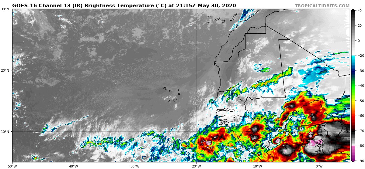
Wow these waves already looks quite vigorous 
4 likes
-
GrayLancer18

- Tropical Depression

- Posts: 88
- Joined: Mon Sep 02, 2019 2:45 pm
- Contact:
Re: 2020 Indicators: SST's / SAL / MSLP / Steering / Shear / Instability / Sat Images
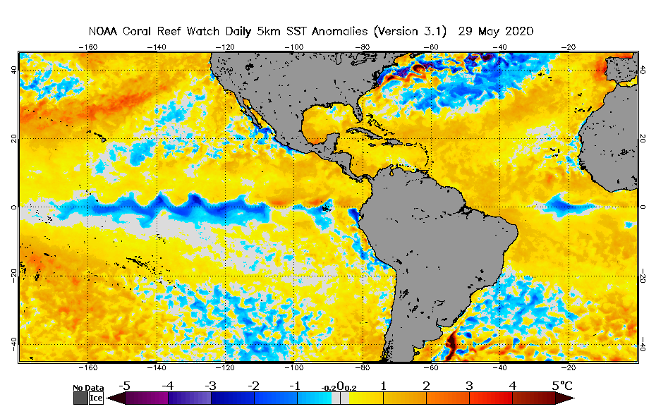
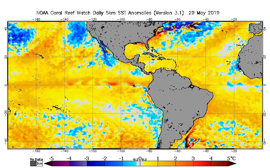
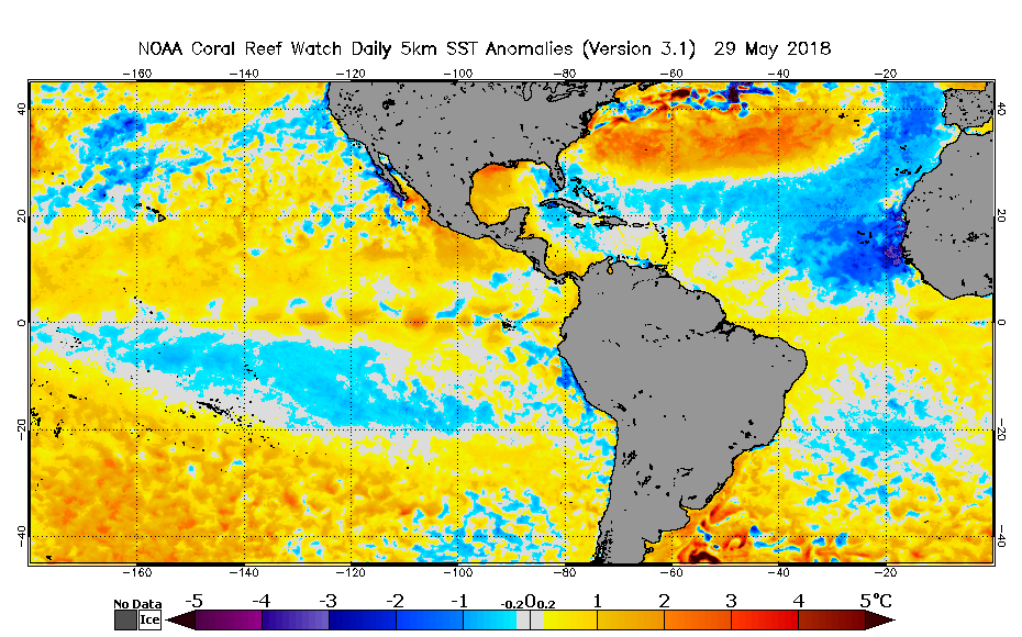
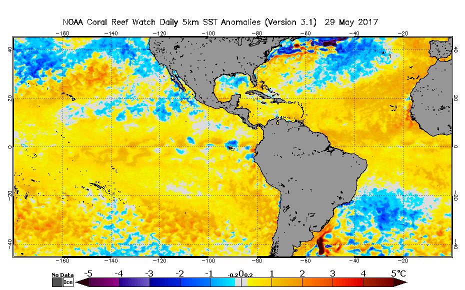
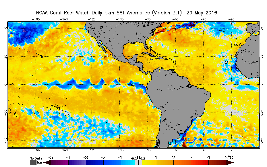
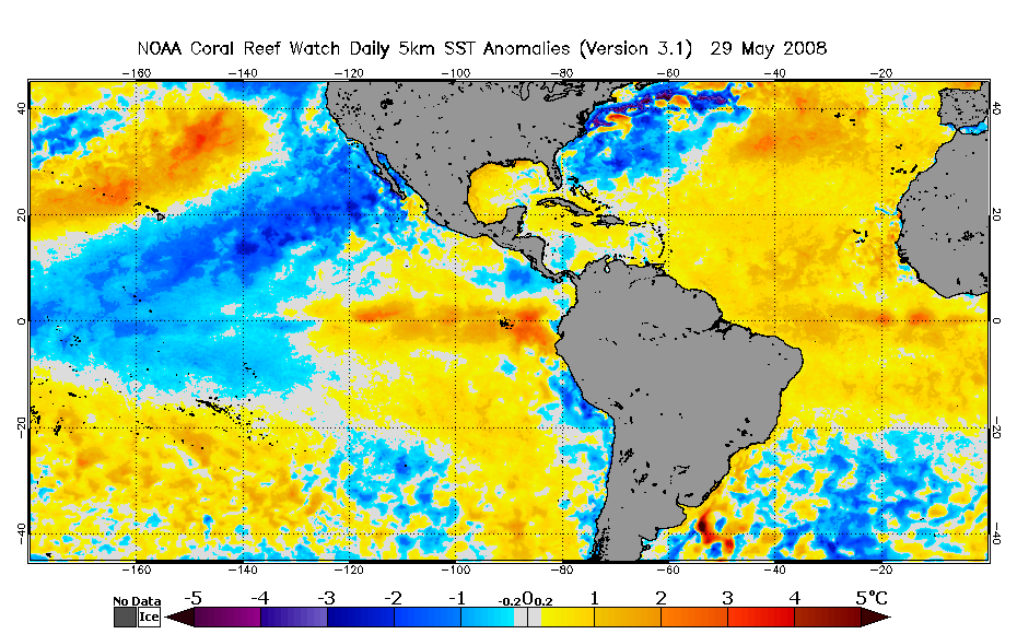
Using the NOAA NESDIS SST charts, I've compared how the anomalies are faring this year compared with the previous 4 and other significant seasons:
This is where this year, currently stands:
2019 (Notice the similar setup but this year, the warm anomalies in the Atlantic are more accentuated and of course, no warm anomalies in the ENSO region):
2018(at this time most were saying the season was cancelled):
2017
2016
2010
2008
The infamous 2005

2004

This is where this year, currently stands:
2019 (Notice the similar setup but this year, the warm anomalies in the Atlantic are more accentuated and of course, no warm anomalies in the ENSO region):
2018(at this time most were saying the season was cancelled):
2017
2016
2010
2008
The infamous 2005
2004
12 likes
Hugo (1989) Hortense (1996) Georges (1998) Jeanne (2004) Irene (2011) Maria (2017)
I am NOT a professional meteorologist nor weather professional. Opinions are my own.
Consult with NHC and NOAA for official forecasts and advisories.
I am NOT a professional meteorologist nor weather professional. Opinions are my own.
Consult with NHC and NOAA for official forecasts and advisories.

Re: 2020 Indicators: SST's / SAL / MSLP / Steering / Shear / Instability / Sat Images
Nawtamet wrote:Using the NOAA NESDIS SST charts, I've compared how the anomalies are faring this year compared with the previous 4 and other significant seasons:
This is where this year, currently stands:
https://coralreefwatch.noaa.gov/data/5km/v3.1/image/daily/ssta/gif/2020/coraltemp5km_ssta_20200529_west.gif
2019 (Notice the similar setup but this year, the warm anomalies in the Atlantic are more accentuated and of course, no warm anomalies in the ENSO region):
https://coralreefwatch.noaa.gov/data/5km/v3.1/image/daily/ssta/gif/2019/coraltemp5km_ssta_20190529_west.gif
2018(at this time most were saying the season was cancelled):
https://coralreefwatch.noaa.gov/data/5km/v3.1/image/daily/ssta/gif/2018/coraltemp5km_ssta_20180529_west.gif
2017
https://coralreefwatch.noaa.gov/data/5km/v3.1/image/daily/ssta/gif/2017/coraltemp5km_ssta_20170529_west.gif
2016
https://coralreefwatch.noaa.gov/data/5km/v3.1/image/daily/ssta/gif/2016/coraltemp5km_ssta_20160529_west.gif
2010
https://coralreefwatch.noaa.gov/data/5km/v3.1/image/daily/ssta/gif/2010/coraltemp5km_ssta_20100529_west.gif
2008
https://coralreefwatch.noaa.gov/data/5km/v3.1/image/daily/ssta/gif/2008/coraltemp5km_ssta_20080529_west.gif
The infamous 2005
https://coralreefwatch.noaa.gov/data/5km/v3.1/image/daily/ssta/gif/2005/coraltemp5km_ssta_20050529_west.gif
2004
https://coralreefwatch.noaa.gov/data/5km/v3.1/image/daily/ssta/gif/2004/coraltemp5km_ssta_20040529_west.gif
Oh wow, the current setup is actually looking pretty favorable compared to those other years. It’s no 2005 or 2010 (that MDR warmth is incredible), but a primarily warmer-than-average MDR plus a cool ENSO is certainly a recipe for an active season.
2020’s May 29th SST anomalies look roughly as favorable as 2016 and 2017, and better than 2004, 2008, and especially 2018.
1 likes
Irene '11 Sandy '12 Hermine '16 5/15/2018 Derecho Fay '20 Isaias '20 Elsa '21 Henri '21 Ida '21
I am only a meteorology enthusiast who knows a decent amount about tropical cyclones. Look to the professional mets, the NHC, or your local weather office for the best information.
I am only a meteorology enthusiast who knows a decent amount about tropical cyclones. Look to the professional mets, the NHC, or your local weather office for the best information.
-
Shell Mound
- Category 5
- Posts: 2432
- Age: 33
- Joined: Thu Sep 07, 2017 3:39 pm
- Location: St. Petersburg, FL → Scandinavia
Re: 2020 Indicators: SST's / SAL / MSLP / Steering / Shear / Instability / Sat Images
Over the past few weeks, the situation in the Atlantic has finally begun to evolve toward a prototypical +AMO in the MDR/Caribbean. The subtropical Atlantic has cooled down significantly, especially just to the N and W of the MDR, while pronounced warming is ongoing from the Canaries to the Cabo Verde islands and along the equator. SST maps are starting to show signs of a +AMO “horseshoe” just off West Africa. Trades have also been much weaker than observed previously. With relatively weaker trades likely to persist over the eastern MDR over the next week, continued warming of the +AMO “tongue” appears quite probable, given the strong Scandinavian block evolving into a west-based -NAO during the same time-frame. (As an aside, the CFSv2 now shows a solid +AMO with relatively cooler subtropics vs. the MDR/Caribbean during ASO of 2020.)
Last edited by Shell Mound on Mon Jun 01, 2020 8:58 am, edited 1 time in total.
0 likes
CVW / MiamiensisWx / Shell Mound
The posts in this forum are NOT official forecasts and should not be used as such. They are just the opinion of the poster and may or may not be backed by sound meteorological data. They are NOT endorsed by any professional institution or STORM2K. For official information, please refer to products from the NHC and NWS.
-
TheStormExpert
Re: 2020 Indicators: SST's / SAL / MSLP / Steering / Shear / Instability / Sat Images
This is good news to hear considering what has been ongoing this year!
https://twitter.com/JohnMoralesNBC6/status/1267450992087445506
https://twitter.com/JohnMoralesNBC6/status/1267450992087445506
3 likes

Re: 2020 Indicators: SST's / SAL / MSLP / Steering / Shear / Instability / Sat Images
I'm not sure if there's any kept records for this sort of thing but I wonder what is the record total number of (combined Pacific & Atlantic) named storms that have spawn from any one of these large gyre type events??
The question popped in my head when I considered that we already had Amanda, will likely soon have Cristobal, and per some models may potentially have Dolly as well. Maybe my memory is a bit fuzzy but I don't think I remember any situations where there were more then 2 named storms that occurred within several days from any past Central American gyre features.
The question popped in my head when I considered that we already had Amanda, will likely soon have Cristobal, and per some models may potentially have Dolly as well. Maybe my memory is a bit fuzzy but I don't think I remember any situations where there were more then 2 named storms that occurred within several days from any past Central American gyre features.
0 likes
Andy D
(For official information, please refer to the NHC and NWS products.)
(For official information, please refer to the NHC and NWS products.)


Who is online
Users browsing this forum: Landy and 208 guests