South Florida could very well see some impacts this season potentially coming from the Caribbean.
https://twitter.com/bennollweather/status/1402288055243866117
2021 Indicators: SST's / SAL / MSLP / Shear / Steering / Instability / Sat Images
Moderator: S2k Moderators
Forum rules

The posts in this forum are NOT official forecasts and should not be used as such. They are just the opinion of the poster and may or may not be backed by sound meteorological data. They are NOT endorsed by any professional institution or STORM2K. For official information, please refer to products from the National Hurricane Center and National Weather Service.
-
Loveweather12
- Tropical Storm

- Posts: 136
- Joined: Thu Aug 20, 2020 2:37 pm
Re: 2021 Indicators: SST's / SAL / MSLP / Shear / Steering / Instability / Sat Images
SFLcane wrote:South Florida could very well see some impacts this season potentially coming from the Caribbean.
https://twitter.com/bennollweather/status/1402288055243866117
How accurate are these? Did the maps get these right last year?
Thank you for always posting & keeping us up to date. I’m watching in FL because it’s been sooo dry
1 likes
-
SFLcane

- S2K Supporter

- Posts: 10281
- Age: 48
- Joined: Sat Jun 05, 2010 1:44 pm
- Location: Lake Worth Florida
Re: 2021 Indicators: SST's / SAL / MSLP / Shear / Steering / Instability / Sat Images
Loveweather12 wrote:SFLcane wrote:South Florida could very well see some impacts this season potentially coming from the Caribbean.
https://twitter.com/bennollweather/status/1402288055243866117
How accurate are these? Did the maps get these right last year?
Thank you for always posting & keeping us up to date. I’m watching in FL because it’s been sooo dry
Hello, the fact it’s the 3rd time in row it was sure an eye opener for me atleast. NMME was actually pretty good last season. I would make sure your stocked up this season as you should every year.
2 likes
-
Blown Away

- S2K Supporter
- Posts: 10253
- Joined: Wed May 26, 2004 6:17 am
Re: 2021 Indicators: SST's / SAL / MSLP / Shear / Steering / Instability / Sat Images
SFLcane wrote:Loveweather12 wrote:SFLcane wrote:South Florida could very well see some impacts this season potentially coming from the Caribbean.
https://twitter.com/bennollweather/status/1402288055243866117
How accurate are these? Did the maps get these right last year?
Thank you for always posting & keeping us up to date. I’m watching in FL because it’s been sooo dry
Hello, the fact it’s the 3rd time in row it was sure an eye opener for me atleast. NMME was actually pretty good last season. I would make sure your stocked up this season as you should every year.
SFLcane do you have a link to run that model?
0 likes
Hurricane Eye Experience: David 79, Irene 99, Frances 04, Jeanne 04, Wilma 05… Hurricane Brush Experience: Andrew 92, Erin 95, Floyd 99, Matthew 16, Irma 17, Ian 22, Nicole 22…
-
SFLcane
- S2K Supporter
- Posts: 10281
- Age: 48
- Joined: Sat Jun 05, 2010 1:44 pm
- Location: Lake Worth Florida
Re: 2021 Indicators: SST's / SAL / MSLP / Shear / Steering / Instability / Sat Images
Blown Away wrote:SFLcane wrote:Loveweather12 wrote:How accurate are these? Did the maps get these right last year?
Thank you for always posting & keeping us up to date. I’m watching in FL because it’s been sooo dry
Hello, the fact it’s the 3rd time in row it was sure an eye opener for me atleast. NMME was actually pretty good last season. I would make sure your stocked up this season as you should every year.
SFLcane do you have a link to run that model?
Hello friend,
Right now I am confused CPC maps paint a different picture then what Ben Noll is using. I was only going but what he considered “ hot spots” on his maps so that kinda caught my eye a bit. Not sure frankly what to believe.
2 likes
-
Shell Mound
- Category 5

- Posts: 2432
- Age: 33
- Joined: Thu Sep 07, 2017 3:39 pm
- Location: St. Petersburg, FL → Scandinavia
Re: 2021 Indicators: SST's / SAL / MSLP / Shear / Steering / Instability / Sat Images
https://twitter.com/BenNollWeather/status/1402574800183173122
https://twitter.com/WxTca/status/1402324507277279233
https://twitter.com/TheSnowDreamer/status/1400920231279841293
https://twitter.com/TheSnowDreamer/status/1400922695378821124
https://twitter.com/AndyHazelton/status/1402691373170634753
https://twitter.com/WxTca/status/1402324507277279233
https://twitter.com/TheSnowDreamer/status/1400920231279841293
https://twitter.com/TheSnowDreamer/status/1400922695378821124
https://twitter.com/AndyHazelton/status/1402691373170634753
1 likes
CVW / MiamiensisWx / Shell Mound
The posts in this forum are NOT official forecasts and should not be used as such. They are just the opinion of the poster and may or may not be backed by sound meteorological data. They are NOT endorsed by any professional institution or STORM2K. For official information, please refer to products from the NHC and NWS.

Re: 2021 Indicators: SST's / SAL / MSLP / Shear / Steering / Instability / Sat Images
Shell Mound wrote:https://twitter.com/BenNollWeather/status/1402574800183173122
https://twitter.com/WxTca/status/1402324507277279233
https://twitter.com/TheSnowDreamer/status/1400920231279841293
https://twitter.com/TheSnowDreamer/status/1400922695378821124
https://twitter.com/AndyHazelton/status/1402691373170634753
The MDR cooling might be due to how sensitive this map is to SAL outbreaks, but if MDR SSTs do remain this cool for an extended period of time (like a couple of weeks), then I can see stability becoming a huge issue and bringing down seasonal numbers.
2 likes
Irene '11 Sandy '12 Hermine '16 5/15/2018 Derecho Fay '20 Isaias '20 Elsa '21 Henri '21 Ida '21
I am only a meteorology enthusiast who knows a decent amount about tropical cyclones. Look to the professional mets, the NHC, or your local weather office for the best information.
I am only a meteorology enthusiast who knows a decent amount about tropical cyclones. Look to the professional mets, the NHC, or your local weather office for the best information.
-
captainbarbossa19

- Professional-Met

- Posts: 1094
- Age: 27
- Joined: Wed Aug 21, 2019 11:09 pm
- Location: Beaumont, TX
Re: 2021 Indicators: SST's / SAL / MSLP / Shear / Steering / Instability / Sat Images
tolakram wrote:captainbarbossa19 wrote:How many times must we go through this? Looking at the current SST Atlantic configuration and trying to predict its peak season configuration is like trying to tell me what the weather will be in 5 years at a specific spot. Didn't we all learn this the hard way a few years ago? Seems to me many said that the configuration would be a problem a few years ago and yet somehow, the SST managed to rebound in the tropical Atlantic and became one of the warmest spots at peak season. We do not know what is going to happen. There may be some similar analog years that we can look at, but it is honestly way too early to know what will transpire at peak season now. Also, let's not start on the SAL either. We have seen years when SAL was very thick early and still managed to have a hyperactive season. We have also seen SAL with rather thin levels and hyperactive seasons. Let us see what will happen and stop trying to correlate one or two events as the direct link to seasonal activity.
It's the indicators thread, we discuss indicators.
Look, I have to do the same thing every year. People in global model threads say don't look too far out. People in storm model threads say don't pay attention to the models until there's a center. It get's old. I feel like posts such as this (sorry to pick on you, this isn't unique) are attempting to shutdown conversation and I don't like it. We're in a thread to discuss indicators.
I may have misspoken before. I am not trying to shut down conversation on this thread. My comments are more directed towards some of these social media "professionals" who know that climatology is comprised of many factors. Some of these have been posting assumptions about the season based on one or two factors. While I do not have a problem with being able to state what you think about climatology, these "professionals" should know from past experience and history not to base an argument on one or two climatological factors. Doing so is setting themselves up for poor credibility.
5 likes
-
cycloneye

- Admin

- Posts: 149508
- Age: 69
- Joined: Thu Oct 10, 2002 10:54 am
- Location: San Juan, Puerto Rico
Re: 2021 Indicators: SST's / SAL / MSLP / Shear / Steering / Instability / Sat Images
2013 moment?
https://twitter.com/webberweather/status/1402690267510046723
https://twitter.com/webberweather/status/1402693511518973954
https://twitter.com/webberweather/status/1402690267510046723
https://twitter.com/webberweather/status/1402693511518973954
0 likes
Visit the Caribbean-Central America Weather Thread where you can find at first post web cams,radars
and observations from Caribbean basin members Click Here
and observations from Caribbean basin members Click Here
-
weeniepatrol

- Category 5
- Posts: 1343
- Joined: Sat Aug 22, 2020 5:30 pm
- Location: WA State
Re: 2021 Indicators: SST's / SAL / MSLP / Shear / Steering / Instability / Sat Images
After the last five years every mention of 2013 only makes me more bullish on the season :]
Watch the mdr be 1C above average by august.
Watch the mdr be 1C above average by august.
6 likes
-
Category5Kaiju

- Category 5
- Posts: 4334
- Joined: Thu Dec 24, 2020 12:45 pm
- Location: Seattle and Phoenix
Re: 2021 Indicators: SST's / SAL / MSLP / Shear / Steering / Instability / Sat Images
Last edited by Category5Kaiju on Wed Jun 09, 2021 4:00 pm, edited 2 times in total.
0 likes
Unless explicitly stated, all info in my posts is based on my own opinions and observations. Tropical storms and hurricanes can be extremely dangerous. Refer to an accredited weather research agency or meteorologist if you need to make serious decisions regarding an approaching storm.
-
Category5Kaiju
- Category 5
- Posts: 4334
- Joined: Thu Dec 24, 2020 12:45 pm
- Location: Seattle and Phoenix
Re: 2021 Indicators: SST's / SAL / MSLP / Shear / Steering / Instability / Sat Images
weeniepatrol wrote:After the last five years every mention of 2013 only makes me more bullish on the season :]
Watch the mdr be 1C above average by august.
At least in my opinion, 2013 was a year that was extremely specific, and it just so happened to have the right conditions to allow it to occur, much like a polar opposite of 2005. While there are talks of another 2013 occurring, I still personally am not sure how much that should be believed, especially given how extraordinary and extreme that year was (I mean, it literally had zero major hurricanes) and that the analog years for this year are 1996, 2001, 2008, 2011, and 2017 (with 2013 not being an analog year from my understanding). Idk, I'm no pro met so I'm sure others may have better insight into this...additionally, while I am not trying to point out certain individuals in particular (just a generic observation I've noticed, especially with the 2013 comments finally coming in now), but didn't people in each of the past like 4 or so seasons say it was going to be another 2013 at least at some point before the meat of the season occurred?
3 likes
Unless explicitly stated, all info in my posts is based on my own opinions and observations. Tropical storms and hurricanes can be extremely dangerous. Refer to an accredited weather research agency or meteorologist if you need to make serious decisions regarding an approaching storm.
Re: 2021 Indicators: SST's / SAL / MSLP / Shear / Steering / Instability / Sat Images
I’m seeing a lot of mixed signals over the last few days:
1.) Atmospheric and -IMO state favoring a return to cool ENSO and cool ENSO atmosphere conditions
2.) Significant cooling of the MDR (possibly from this first SAL outbreak)
3.) Moisture/precipitation forecasts for ASO are pretty decent, and some models show a warm tropical Atlantic with a more favorable (+AMO) look than what is currently seen.
4.) The MJO has been in Phases 7 and 8 a good amount, similar to seasons with an abrupt change to +ENSO like 2006 and 2009
5.) The AMOC appears to have slowed which could result in unfavorable conditions by ASO.
If I’m interpreting these signals correctly, there are two possibilities: we get a favorable Atlantic and cool ENSO as models like the CFS are showing, or there’s an unexpected, sudden shift to warm ENSO with increased shear and stability across the Atlantic.
1 likes
Irene '11 Sandy '12 Hermine '16 5/15/2018 Derecho Fay '20 Isaias '20 Elsa '21 Henri '21 Ida '21
I am only a meteorology enthusiast who knows a decent amount about tropical cyclones. Look to the professional mets, the NHC, or your local weather office for the best information.
I am only a meteorology enthusiast who knows a decent amount about tropical cyclones. Look to the professional mets, the NHC, or your local weather office for the best information.
-
Category5Kaiju
- Category 5
- Posts: 4334
- Joined: Thu Dec 24, 2020 12:45 pm
- Location: Seattle and Phoenix
Re: 2021 Indicators: SST's / SAL / MSLP / Shear / Steering / Instability / Sat Images
I am beginning to wonder if this season’s true activity potential will not be known until August or so. This is perhaps one of the hardest to predict seasons we have had in a while imho
4 likes
Unless explicitly stated, all info in my posts is based on my own opinions and observations. Tropical storms and hurricanes can be extremely dangerous. Refer to an accredited weather research agency or meteorologist if you need to make serious decisions regarding an approaching storm.
-
Shell Mound
- Category 5
- Posts: 2432
- Age: 33
- Joined: Thu Sep 07, 2017 3:39 pm
- Location: St. Petersburg, FL → Scandinavia
Re: 2021 Indicators: SST's / SAL / MSLP / Shear / Steering / Instability / Sat Images
cycloneye wrote:https://twitter.com/webberweather/status/1402693511518973954
“A slower amoc cools the Atlantic, resulting in reduced hurricane activity through teleconnections in the hadley & ferrell cells which speed up the trades/strengthen the AB high, increase SAL adv, & cool tropical ATL SSTs
-- Eric Webb (@webberweather) June 9, 2021”
If the slower AMOC is related to climate feedback vis-à-vis Greenland ice melt, then doesn’t this confirm that a warmer climate → -AMO → inactive seasons?
0 likes
CVW / MiamiensisWx / Shell Mound
The posts in this forum are NOT official forecasts and should not be used as such. They are just the opinion of the poster and may or may not be backed by sound meteorological data. They are NOT endorsed by any professional institution or STORM2K. For official information, please refer to products from the NHC and NWS.
-
Shell Mound
- Category 5
- Posts: 2432
- Age: 33
- Joined: Thu Sep 07, 2017 3:39 pm
- Location: St. Petersburg, FL → Scandinavia
Re: 2021 Indicators: SST's / SAL / MSLP / Shear / Steering / Instability / Sat Images
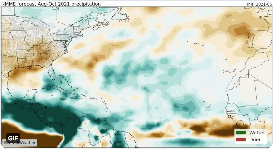
Based on all the data, the June NMME forecast for ASO suggests a blend of positive and negative factors. On the one hand, the active African monsoon creates a configuration similar to that of the +AMO, with a wet Sahel, dry intermediate zone, and wet Gulf of Guinea. On the other, the dry anomalies near the Leeward Islands, coupled with wet anomalies over the subtropics just to the north, suggest a strong TUTT in the region, which is more characteristic of the -AMO, especially given the otherwise favourable -ENSO in place. Note, however, that the wet anomaly near the northwestern Bahamas, southern Florida, and the Straits of Florida is more typical of a +AMO than -AMO. 2012 might be a decent analog in terms of tracks.
0 likes
CVW / MiamiensisWx / Shell Mound
The posts in this forum are NOT official forecasts and should not be used as such. They are just the opinion of the poster and may or may not be backed by sound meteorological data. They are NOT endorsed by any professional institution or STORM2K. For official information, please refer to products from the NHC and NWS.
-
Category5Kaiju
- Category 5
- Posts: 4334
- Joined: Thu Dec 24, 2020 12:45 pm
- Location: Seattle and Phoenix
Re: 2021 Indicators: SST's / SAL / MSLP / Shear / Steering / Instability / Sat Images
Shell Mound wrote:cycloneye wrote:https://twitter.com/webberweather/status/1402693511518973954
“A slower amoc cools the Atlantic, resulting in reduced hurricane activity through teleconnections in the hadley & ferrell cells which speed up the trades/strengthen the AB high, increase SAL adv, & cool tropical ATL SSTs
-- Eric Webb (@webberweather) June 9, 2021”
If the slower AMOC is related to climate feedback vis-à-vis Greenland ice melt, then doesn’t this confirm that a warmer climate → -AMO → inactive seasons?
Also just curious but is this AMOC slowing exclusive and anomalous to this year, like did it not occur or was discernable at some point before the hurricane season really kicked into action in any other years between 2013 and 2021? I'd have to imagine that many of these forecasting agencies (Phil Klotzbach included) would have learned from their mistakes in 2013 and would have advanced their skills over the past years to include more variables and factors in predicting a particular season's activity, especially the ones that were missed when 2013 occurred.
0 likes
Unless explicitly stated, all info in my posts is based on my own opinions and observations. Tropical storms and hurricanes can be extremely dangerous. Refer to an accredited weather research agency or meteorologist if you need to make serious decisions regarding an approaching storm.
-
AutoPenalti
- Category 5
- Posts: 4091
- Age: 29
- Joined: Mon Aug 17, 2015 4:16 pm
- Location: Ft. Lauderdale, Florida
Re: 2021 Indicators: SST's / SAL / MSLP / Shear / Steering / Instability / Sat Images
Category5Kaiju wrote:Shell Mound wrote:cycloneye wrote:https://twitter.com/webberweather/status/1402693511518973954
“A slower amoc cools the Atlantic, resulting in reduced hurricane activity through teleconnections in the hadley & ferrell cells which speed up the trades/strengthen the AB high, increase SAL adv, & cool tropical ATL SSTs
-- Eric Webb (@webberweather) June 9, 2021”
If the slower AMOC is related to climate feedback vis-à-vis Greenland ice melt, then doesn’t this confirm that a warmer climate → -AMO → inactive seasons?
Also just curious but is this AMOC slowing exclusive and anomalous to this year, like did it not occur or was discernable at some point before the hurricane season really kicked into action in any other years between 2013 and 2021? I'd have to imagine that many of these forecasting agencies (Phil Klotzbach included) would have learned from their mistakes in 2013 and would have advanced their skills over the past years to include more variables and factors in predicting a particular season's activity, especially the ones that were missed when 2013 occurred.
That's what I was thinking, there are some that haven't really touched on this AMOC chart from what I can see.
0 likes
The posts in this forum are NOT official forecasts and should not be used as such. They are just the opinion of the poster and may or may not be backed by sound meteorological data. They are NOT endorsed by any professional institution or STORM2K. For official information, please refer to products from the NHC and NWS.
Model Runs Cheat Sheet:
GFS (5:30 AM/PM, 11:30 AM/PM)
HWRF, GFDL, UKMET, NAVGEM (6:30-8:00 AM/PM, 12:30-2:00 AM/PM)
ECMWF (1:45 AM/PM)
TCVN is a weighted averaged
-
HurricaneEnzo

- Category 2

- Posts: 744
- Joined: Wed Mar 14, 2018 12:18 pm
- Location: Newport, NC (Hurricane Alley)
Re: 2021 Indicators: SST's / SAL / MSLP / Shear / Steering / Instability / Sat Images
Category5Kaiju wrote:weeniepatrol wrote:After the last five years every mention of 2013 only makes me more bullish on the season :]
Watch the mdr be 1C above average by august.
At least in my opinion, 2013 was a year that was extremely specific, and it just so happened to have the right conditions to allow it to occur, much like a polar opposite of 2005. While there are talks of another 2013 occurring, I still personally am not sure how much that should be believed, especially given how extraordinary and extreme that year was (I mean, it literally had zero major hurricanes) and that the analog years for this year are 1996, 2001, 2008, 2011, and 2017 (with 2013 not being an analog year from my understanding). Idk, I'm no pro met so I'm sure others may have better insight into this...additionally, while I am not trying to point out certain individuals in particular (just a generic observation I've noticed, especially with the 2013 comments finally coming in now), but didn't people in each of the past like 4 or so seasons say it was going to be another 2013 at least at some point before the meat of the season occurred?
While I agree we likely won't see a repeat of 2013 we always have to take analogs with a grain of salt. Some of the top analogs leading up to 'tornado season' this year were 1974, 2008, and 2011. I think it is safe to say that 2021 has been the polar opposite of those years.
0 likes
Bertha 96' - Fran 96' - Bonnie 98' - Dennis 99' - Floyd 99' - Isabel 03' - Alex 04' - Ophelia 05' - Irene 11' - Arthur 14' - Matthew 16' - Florence 18' - Dorian 19' - Isaias 20' (countless other tropical storms and Hurricane swipes)
I am not a Professional Met just an enthusiast. Get your weather forecasts from the Pros!
I am not a Professional Met just an enthusiast. Get your weather forecasts from the Pros!
Who is online
Users browsing this forum: No registered users and 179 guests