ENSO Updates (2007 thru 2023)

This is the general tropical discussion area. Anyone can take their shot at predicting a storms path.

Moderator: S2k Moderators

Forum rules

The posts in this forum are NOT official forecasts and should not be used as such. They are just the opinion of the poster and may or may not be backed by sound meteorological data. They are NOT endorsed by any professional institution or STORM2K. For official information, please refer to products from the National Hurricane Center and National Weather Service.

Help Support Storm2K
Message
Author
User avatar
cycloneye
Admin
Admin
Posts: 145467
Age: 68
Joined: Thu Oct 10, 2002 10:54 am
Location: San Juan, Puerto Rico

Re: ENSO: Latest plume of ENSO Models of Mid-December is up

#6801 Postby cycloneye » Thu Dec 17, 2015 2:22 pm

Here is the latest forecast from all the ENSO models about how will things evolve en the ENSO factor.The update of Mid-December shows The Strong El Nino fading fast after Febuary and will be gone by May.After that it will be in Neutral territory and after July La Nina comes to the forefront.Of course this is only a forecast from the models and things can change especially in long range so let's see what occurs in reality in the next few months.

http://iri.columbia.edu/our-expertise/c ... o/current/

Image

Image
0 likes   
Visit the Caribbean-Central America Weather Thread where you can find at first post web cams,radars
and observations from Caribbean basin members Click Here

User avatar
Ntxw
Storm2k Moderator
Storm2k Moderator
Posts: 22787
Joined: Wed Oct 21, 2009 6:34 pm
Location: DFW, Texas

Re: ENSO: Latest plume of ENSO Models of Mid-December is up

#6802 Postby Ntxw » Thu Dec 17, 2015 2:32 pm

:uarrow: Here is the trimonthly (ONI) forecast from the combined guidance. Starting with DJF. It has MJJ as the official end to the Nino event below 0.5C

Code: Select all

2.4   2.1   1.6   1.2   0.7   0.3   0   -0.2   -0.4
0 likes   
The above post and any post by Ntxw is NOT an official forecast and should not be used as such. It is just the opinion of the poster and may or may not be backed by sound meteorological data. It is NOT endorsed by any professional institution including Storm2k. For official information, please refer to NWS products.

  Help support Storm2K!
Help Support Storm2K

User avatar
Ntxw
Storm2k Moderator
Storm2k Moderator
Posts: 22787
Joined: Wed Oct 21, 2009 6:34 pm
Location: DFW, Texas

#6803 Postby Ntxw » Thu Dec 17, 2015 5:11 pm

Latest Jason 2 side by side with 1997 figuring SSH anomalies

Image
0 likes   
The above post and any post by Ntxw is NOT an official forecast and should not be used as such. It is just the opinion of the poster and may or may not be backed by sound meteorological data. It is NOT endorsed by any professional institution including Storm2k. For official information, please refer to NWS products.


  Help support Storm2K!

Help Support Storm2K


HURRICANELONNY
Category 5
Category 5
Posts: 1383
Joined: Wed May 07, 2003 6:48 am
Location: HOLLYWOOD.FL

Re: ENSO: Latest plume of ENSO Models of Mid-December is up

#6804 Postby HURRICANELONNY » Sun Dec 20, 2015 11:19 am

Nice sst map. I've been watching the soi go positive last few days. Seems nino3.4 rises when soi goes +. Maybe just a coincedence but it's not the first time i've seen that.

http://www.tropicaltidbits.com/analysis/nino34.png
0 likes   
hurricanelonny

User avatar
Ntxw
Storm2k Moderator
Storm2k Moderator
Posts: 22787
Joined: Wed Oct 21, 2009 6:34 pm
Location: DFW, Texas

#6805 Postby Ntxw » Mon Dec 21, 2015 8:40 am

Nino nudged back up to 2.9C this week
0 likes   
The above post and any post by Ntxw is NOT an official forecast and should not be used as such. It is just the opinion of the poster and may or may not be backed by sound meteorological data. It is NOT endorsed by any professional institution including Storm2k. For official information, please refer to NWS products.


  Help support Storm2K!

Help Support Storm2K


User avatar
cycloneye
Admin
Admin
Posts: 145467
Age: 68
Joined: Thu Oct 10, 2002 10:54 am
Location: San Juan, Puerto Rico

Re: ENSO Updates

#6806 Postby cycloneye » Mon Dec 21, 2015 9:38 am

Text of CPC update of 12/21/15 that has Nino 3.4 up to +2.9C.

http://www.cpc.ncep.noaa.gov/products/a ... ts-web.pdf
0 likes   
Visit the Caribbean-Central America Weather Thread where you can find at first post web cams,radars
and observations from Caribbean basin members Click Here

User avatar
NDG
S2K Supporter
S2K Supporter
Posts: 15446
Joined: Sun Jul 09, 2006 10:14 pm
Location: Orlando, FL

Re: ENSO Updates

#6807 Postby NDG » Mon Dec 21, 2015 9:44 am

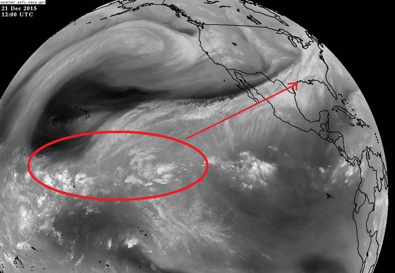
The subtropical jet is in full force this week thanks to this super strong El Nino, moisture source all the way from the central Pacific in the upper levels, will give a very wet week to the northern gulf coast & SE US through Christmas.

Image
0 likes   

User avatar
ronjon
Category 5
Category 5
Posts: 4822
Joined: Fri Aug 19, 2005 5:17 pm
Location: Hernando Beach, FL

Re: ENSO: CPC update of 12/21/15: Nino 3.4 up to +2.9C

#6808 Postby ronjon » Mon Dec 21, 2015 9:55 am

Missing central Florida again NDG. This El Nino is turning out to be a big forecast bust for high rainfall and cooler than normal temps. Strong subtropical ridging leading to dry and warm conditions. Will be 87 degrees on Christmas day. This forecast along with the tropical cyclone forecast bust of 2014 is giving long term forecasting a black eye for US METs.
0 likes   

User avatar
NDG
S2K Supporter
S2K Supporter
Posts: 15446
Joined: Sun Jul 09, 2006 10:14 pm
Location: Orlando, FL

Re: ENSO: CPC update of 12/21/15: Nino 3.4 up to +2.9C

#6809 Postby NDG » Mon Dec 21, 2015 10:11 am

ronjon wrote:Missing central Florida again NDG. This El Nino is turning out to be a big forecast bust for high rainfall and cooler than normal temps. Strong subtropical ridging leading to dry and warm conditions. Will be 87 degrees on Christmas day. This forecast along with the tropical cyclone forecast bust of 2014 is giving long term forecasting a black eye for US METs.


Mets should know that not every El Nino is the same, for example the pacific NW has been way wetter during the Fall than forecasted, it all comes down to the sypnotic pattern as always. IMO.
So far the pattern has been very similar to 82/83 El Nino, that winter the Orlando area had a drier than average November & December, then little by little the wetter & "cooler" pattern started setting in later in January, especially in February & March which were much wetter than average.
0 likes   

User avatar
Ntxw
Storm2k Moderator
Storm2k Moderator
Posts: 22787
Joined: Wed Oct 21, 2009 6:34 pm
Location: DFW, Texas

#6810 Postby Ntxw » Mon Dec 21, 2015 10:41 am

Yeah El Nino is a long term background state. Sometimes we try too much to put it on day to day weather, the sypnotic pattern dictates that. It is well documented in the longer term winter months the stronger the El Nino the warmer it is likely to be in the eastern conus. It is the weaker and moderate events that is more skewed to cold. Pac NW being wet is due to the +EPO which is also favored in very strong Nino.
0 likes   
The above post and any post by Ntxw is NOT an official forecast and should not be used as such. It is just the opinion of the poster and may or may not be backed by sound meteorological data. It is NOT endorsed by any professional institution including Storm2k. For official information, please refer to NWS products.


  Help support Storm2K!

Help Support Storm2K


HURRICANELONNY
Category 5
Category 5
Posts: 1383
Joined: Wed May 07, 2003 6:48 am
Location: HOLLYWOOD.FL

Re: ENSO: CPC update of 12/21/15: Nino 3.4 up to +2.9C

#6811 Postby HURRICANELONNY » Mon Dec 21, 2015 6:02 pm

For those who think this El Nino won't effect all of florida better look back at the 97-98 El Nino. Many people lost there lives in central florida back then from a tornado outbreak. We don't usually get effected from el nino's till the winter time. Lets hope it does not end up that severe as 97-98.
0 likes   
hurricanelonny

User avatar
Ntxw
Storm2k Moderator
Storm2k Moderator
Posts: 22787
Joined: Wed Oct 21, 2009 6:34 pm
Location: DFW, Texas

#6812 Postby Ntxw » Tue Dec 22, 2015 1:06 am

Given where it is now (well above 2C) it doesn't appear like the weakening is going to be very fast (relatively speaking in ENSO time). In fact we are approaching the end of December and these readings are still hovering around 3C +/- wow for the weeklies. Wind anomalies are still very Nino like...I think we may ring out two more 2C+ trimonthlies! Crazy as it is. It will weaken faster in time especially after February but it's going to be a drag till then it appears.

CFSv2 doesn't back off much in the way of westerly anomalies through February. No signs of any significant easterlies to weaken either from the GFS

Image
0 likes   
The above post and any post by Ntxw is NOT an official forecast and should not be used as such. It is just the opinion of the poster and may or may not be backed by sound meteorological data. It is NOT endorsed by any professional institution including Storm2k. For official information, please refer to NWS products.


  Help support Storm2K!

Help Support Storm2K


dexterlabio
Category 5
Category 5
Posts: 3470
Joined: Sat Oct 24, 2009 11:50 pm

Re: ENSO: CPC update of 12/21/15: Nino 3.4 up to +2.9C

#6813 Postby dexterlabio » Tue Dec 22, 2015 7:07 am

Looks like a strong MJO signal is about to enter WPAC. Can we expect a bit more warming in the Nino regions due to this?
0 likes   
Personal Forecast Disclaimer:
The posts in this forum are NOT official forecast and should not be used as such. They are just the opinion of the poster and may or may not be backed by sound meteorological data. They are NOT endorsed by any professional institution or storm2k.org. For official information, please refer to the NHC and NWS products.

User avatar
AJC3
Admin
Admin
Posts: 3999
Age: 61
Joined: Tue Aug 31, 2004 7:04 pm
Location: Ballston Spa, New York
Contact:

Re: ENSO: CPC update of 12/21/15: Nino 3.4 up to +2.9C

#6814 Postby AJC3 » Tue Dec 22, 2015 5:14 pm

ronjon wrote:Missing central Florida again NDG. This El Nino is turning out to be a big forecast bust for high rainfall and cooler than normal temps. Strong subtropical ridging leading to dry and warm conditions. Will be 87 degrees on Christmas day. This forecast along with the tropical cyclone forecast bust of 2014 is giving long term forecasting a black eye for US METs.


I sent you a PM regarding this, but since it's been sitting in your inbox unread for a couple weeks, I'll make this public.

First, you first started using the word "bust" a whole week into the 90-day DJF period. We're now only three weeks into that same 90 day period. How about we let this winter evolve a little before making premature speculations about US mets busting their seasonal forecast for Florida? No two warm phases evolve exactly the same.

Yes, here in Florida, we're in the midst of what will be, *by far* the warmest stretch of temperatures in the historical record for the 2.5 month period running from mid OCT through the EOY (as part of what will no doubt wind up being the warmest year on record). And, obviously the higher probabilities for Above Normal DEC rainfall will be overdone.

*However*...

(1) The mid NOV CPC forecast issued for DEC called for increased probabilities of Above Normal temperatures for peninsular Florida, not below normal as you might be thinking.
(2) The same CPC forecast issued for DJF called for Equal Chances of Above/Below/Normal temperatures for all of Florida. Again, not below normal, as is often the case.
(3) Keep in mind that the strongest signal for wet/stormy conditions in Florida during a strong El Nino for the DJF tercile is during February, followed by January. March actually has a stronger signal than January, but it's outside of the DJF period.

If the DJF forecasts do wind up going busto, then rest assured, we'll be trying to figure out what went wrong. But until that becomes apparent, let's stash the bust talk, shall we? It's just as misguided (and annoying) as the "Season Cancel" posts in early August. Thanks.

NDG wrote: Mets should know that not every El Nino is the same, for example the pacific NW has been way wetter during the Fall than forecasted, it all comes down to the sypnotic pattern as always. IMO. So far the pattern has been very similar to 82/83 El Nino, that winter the Orlando area had a drier than average November & December, then little by little the wetter & "cooler" pattern started setting in later in January, especially in February & March which were much wetter than average.

^^^ This. :clap:
0 likes   

User avatar
ronjon
Category 5
Category 5
Posts: 4822
Joined: Fri Aug 19, 2005 5:17 pm
Location: Hernando Beach, FL

Re: ENSO: CPC update of 12/21/15: Nino 3.4 up to +2.9C

#6815 Postby ronjon » Sun Dec 27, 2015 9:57 am

AJC3 wrote:
ronjon wrote:Missing central Florida again NDG. This El Nino is turning out to be a big forecast bust for high rainfall and cooler than normal temps. Strong subtropical ridging leading to dry and warm conditions. Will be 87 degrees on Christmas day. This forecast along with the tropical cyclone forecast bust of 2014 is giving long term forecasting a black eye for US METs.


I sent you a PM regarding this, but since it's been sitting in your inbox unread for a couple weeks, I'll make this public.

First, you first started using the word "bust" a whole week into the 90-day DJF period. We're now only three weeks into that same 90 day period. How about we let this winter evolve a little before making premature speculations about US mets busting their seasonal forecast for Florida? No two warm phases evolve exactly the same.

Yes, here in Florida, we're in the midst of what will be, *by far* the warmest stretch of temperatures in the historical record for the 2.5 month period running from mid OCT through the EOY (as part of what will no doubt wind up being the warmest year on record). And, obviously the higher probabilities for Above Normal DEC rainfall will be overdone.

*However*...

(1) The mid NOV CPC forecast issued for DEC called for increased probabilities of Above Normal temperatures for peninsular Florida, not below normal as you might be thinking.
(2) The same CPC forecast issued for DJF called for Equal Chances of Above/Below/Normal temperatures for all of Florida. Again, not below normal, as is often the case.
(3) Keep in mind that the strongest signal for wet/stormy conditions in Florida during a strong El Nino for the DJF tercile is during February, followed by January. March actually has a stronger signal than January, but it's outside of the DJF period.

If the DJF forecasts do wind up going busto, then rest assured, we'll be trying to figure out what went wrong. But until that becomes apparent, let's stash the bust talk, shall we? It's just as misguided (and annoying) as the "Season Cancel" posts in early August. Thanks.

NDG wrote: Mets should know that not every El Nino is the same, for example the pacific NW has been way wetter during the Fall than forecasted, it all comes down to the sypnotic pattern as always. IMO. So far the pattern has been very similar to 82/83 El Nino, that winter the Orlando area had a drier than average November & December, then little by little the wetter & "cooler" pattern started setting in later in January, especially in February & March which were much wetter than average.

^^^ This. :clap:


Understand Tony but you've got to admit this El Nino is off to a really slow start for peninsular Florida. And once these subtropical ridges get established, they're awful hard to dislodge. I've lived in west-central Florida for over 30 years, and remember drenching rains in November/December in the 1997-98 event, which this current El Nino is most compared to. And you did neglect to note both monthly forecasts for November and December were for above-average rainfall which obviously hasn't panned out. To our METs out there, I seriously hope I'm wrong and the El Nino forecasts do verify over the next 3 months. It does now look like a pattern change in the 500 mb forecast with a long wave trough over the eastern US the first week of January so this might be the first trend toward wetter and cooler conditions for Florida peninsula. And sorry for my inattentiveness to your PM, I don't check this site very often during the winter months and didn't see it till you mentioned it.
0 likes   

User avatar
gigabite
S2K Supporter
S2K Supporter
Posts: 916
Age: 72
Joined: Wed May 05, 2004 4:09 pm
Location: Naples, Florida

#6816 Postby gigabite » Sun Dec 27, 2015 9:45 pm

Global water vapor just popped. The exact quarter may slip a month or two from the long range forecast. It is a very extended guess to make with just weather tools.
0 likes   

User avatar
blp
Category 5
Category 5
Posts: 2840
Age: 46
Joined: Thu Sep 09, 2004 7:51 pm
Location: Miami, FL
Contact:

Re: ENSO Updates

#6817 Postby blp » Sun Dec 27, 2015 10:44 pm

The Southeastern half of the peninsula has been slammed this winter with extreme rainfall. I am personally rather sick of it. Please go away El Nino fast!!!

Image
0 likes   
The following post is NOT an official forecast and should not be used as such. It is just the opinion of the poster and may or may not be backed by sound meteorological data. It is NOT endorsed by any professional institution including storm2k.org For Official Information please refer to the NHC and NWS products.

User avatar
cycloneye
Admin
Admin
Posts: 145467
Age: 68
Joined: Thu Oct 10, 2002 10:54 am
Location: San Juan, Puerto Rico

Re: ENSO Updates

#6818 Postby cycloneye » Mon Dec 28, 2015 3:36 pm

CPC update of 12/28/15 has Nino 3.4 down to +2.7C.Is still early to say if the down trend will continue or will go up again.

http://www.cpc.ncep.noaa.gov/products/a ... ts-web.pdf
0 likes   
Visit the Caribbean-Central America Weather Thread where you can find at first post web cams,radars
and observations from Caribbean basin members Click Here

psyclone
S2K Supporter
S2K Supporter
Posts: 4768
Joined: Wed Aug 24, 2005 9:04 pm
Location: palm harbor fl

#6819 Postby psyclone » Tue Dec 29, 2015 12:01 pm

There's plenty of time for El Nino to deliver a wet, stormy winter to fl. it's already been wet over south florida and while the mid peninsula was warmer and drier than would have been expected it's way too soon to declare a bust. I would bet heavily we get cooler and wetter with some svr wx episodes. the climo is compelling. No one leaves a football game or declares an upset in the 1st quarter. J/F/M should be interesting.
0 likes   

HURRICANELONNY
Category 5
Category 5
Posts: 1383
Joined: Wed May 07, 2003 6:48 am
Location: HOLLYWOOD.FL

Re: ENSO Updates

#6820 Postby HURRICANELONNY » Wed Dec 30, 2015 3:21 pm

0 likes   
hurricanelonny


Return to “Talkin' Tropics”

Who is online

Users browsing this forum: jhpigott, kevin, Killjoy12 and 34 guests