
Ntxw wrote:Here is the subsurface cross of April 1973. Courtesy of ecmwf ocean reanalysis

1973-1974 is one of the strongest La Nina. There were strong ones in 1915-1918, 1955-1956, 1956-1957, 1988-1989, and 2010-2011.
Moderator: S2k Moderators

Ntxw wrote:Here is the subsurface cross of April 1973. Courtesy of ecmwf ocean reanalysis


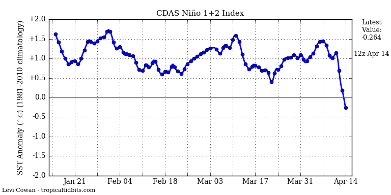
Ntxw wrote:Down to 1.3C this week. If we went the rapid fall (0.2-0.3C drops per week) we would fall below 0.5C by the end of May. If it was stair stepped it would probably be June.
One thing the potential Nina is lacking at the surface thus far is significant above normal trades.
Dean_175 wrote:Ntxw wrote:Down to 1.3C this week. If we went the rapid fall (0.2-0.3C drops per week) we would fall below 0.5C by the end of May. If it was stair stepped it would probably be June.
One thing the potential Nina is lacking at the surface thus far is significant above normal trades.
Why would we expect trades to be significantly above average while still in El Nino?
Ntxw wrote:Dean_175 wrote:Ntxw wrote:Down to 1.3C this week. If we went the rapid fall (0.2-0.3C drops per week) we would fall below 0.5C by the end of May. If it was stair stepped it would probably be June.
One thing the potential Nina is lacking at the surface thus far is significant above normal trades.
Why would we expect trades to be significantly above average while still in El Nino?
Should there not be at least some spurts of stronger trades? I wouldn't expect a reversal until La Nina is established though.
Kingarabian wrote:Ntxw wrote:Dean_175 wrote:Why would we expect trades to be significantly above average while still in El Nino?
Should there not be at least some spurts of stronger trades? I wouldn't expect a reversal until La Nina is established though.
Are La Nina transitions not the same as El Nino transitions? Because you're right. The precursor to this super Nino were patches of strong WWB. Because we all saw what happened 2 years ago... very warm pool surfaced but with no winds kept El Nino at bay.
Also the SOI is tanking again. Looks like the atmosphere is not on the same page.


Yellow Evan wrote:Levi Cowan @TropicalTidbits 3h3 hours ago
Substantial cooling beginning in eastern equatorial Pacific. This did not happen following 1983 and 1998 El Ninos.
Not too surprising given that the El Nino has been more center-based that normal. We could be in store for an extended La Nina with interesting consequences.
Kingarabian wrote:Ntxw wrote:Dean_175 wrote:Why would we expect trades to be significantly above average while still in El Nino?
Should there not be at least some spurts of stronger trades? I wouldn't expect a reversal until La Nina is established though.
Are La Nina transitions not the same as El Nino transitions? Because you're right. The precursor to this super Nino were patches of strong WWB. Because we all saw what happened 2 years ago... very warm pool surfaced but with no winds kept El Nino at bay.
Also the SOI is tanking again. Looks like the atmosphere is not on the same page.
NDG wrote:Kingarabian wrote:Ntxw wrote:
Should there not be at least some spurts of stronger trades? I wouldn't expect a reversal until La Nina is established though.
Are La Nina transitions not the same as El Nino transitions? Because you're right. The precursor to this super Nino were patches of strong WWB. Because we all saw what happened 2 years ago... very warm pool surfaced but with no winds kept El Nino at bay.
Also the SOI is tanking again. Looks like the atmosphere is not on the same page.
Similar to '98 about this same time, when the SOI did not go to a positive regime until June of that year, something to keep in mind.
Dean_175 wrote:Well yes, there can be some spurts of stronger easterlies- but the most important thing for now is that the easterlies be at least near-normal. The El Nino is weakening, but there won't be La Nina atmospheric patterns until there are some cool anomalies at the surface. We will still eventually need to get stronger than normal trades if a La Nina is to actually develop though. In 2014, the surface actually did warm to near El Nino levels- but there were never any westerly anomalies, and so we ended up warm neutral. I guess that if we never had any stronger than normal easterlies at all this year, we could end up just reaching cool neutral.
The thermocline is becoming shallower across the equatorial Pacific, and the subsurface temperatures are up to a few degrees below normal. Even normal trades will produce stronger upwelling of cooler water than normal.

Users browsing this forum: Google [Bot] and 108 guests


