2020 EPAC Season

This is the general tropical discussion area. Anyone can take their shot at predicting a storms path.

Moderator: S2k Moderators

Forum rules

The posts in this forum are NOT official forecasts and should not be used as such. They are just the opinion of the poster and may or may not be backed by sound meteorological data. They are NOT endorsed by any professional institution or STORM2K. For official information, please refer to products from the National Hurricane Center and National Weather Service.

Help Support Storm2K
Message
Author
User avatar
Kingarabian
S2K Supporter
S2K Supporter
Posts: 15980
Joined: Sat Aug 08, 2009 3:06 am
Location: Honolulu, Hawaii

Re: 2020 EPAC Season

#701 Postby Kingarabian » Thu Aug 13, 2020 3:03 pm

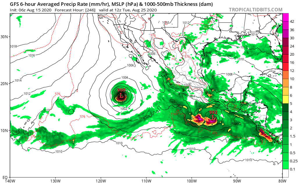
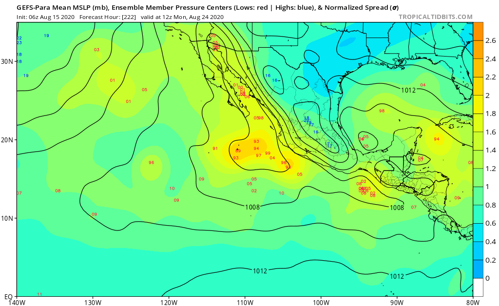
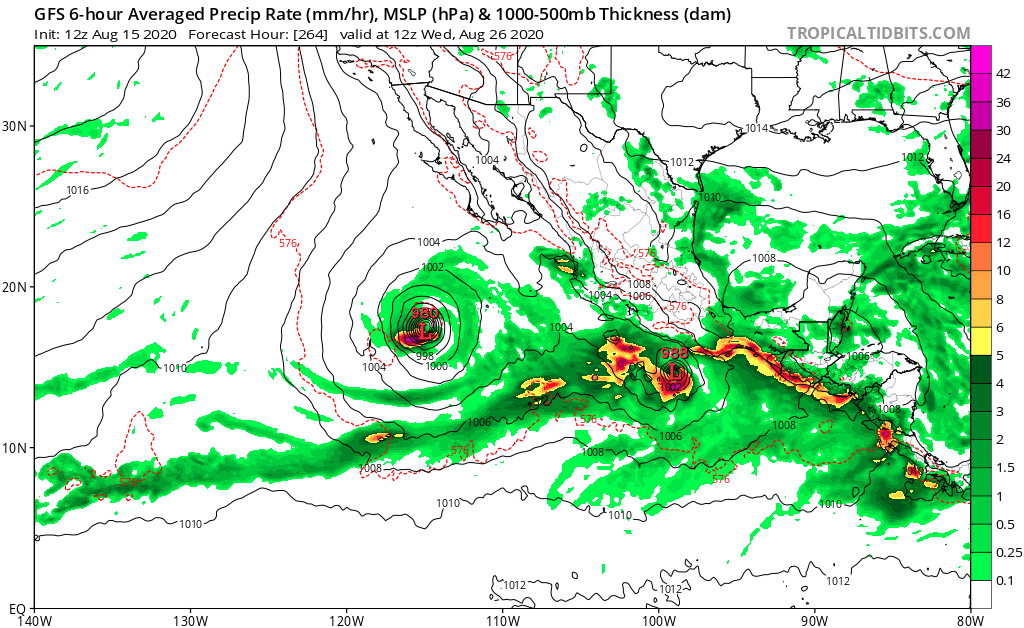
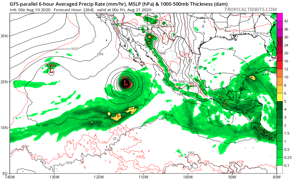
gatorcane wrote:The 12Z ECMWF looking more bullish for the system the GFS insists will become a significant hurricane. Seems if the storm can stay away from Mexico, could become a major:

[url]https://i.postimg.cc/SNbb8r6Y/ecmwf-mslpa-Norm-epac-8.png[/rl]

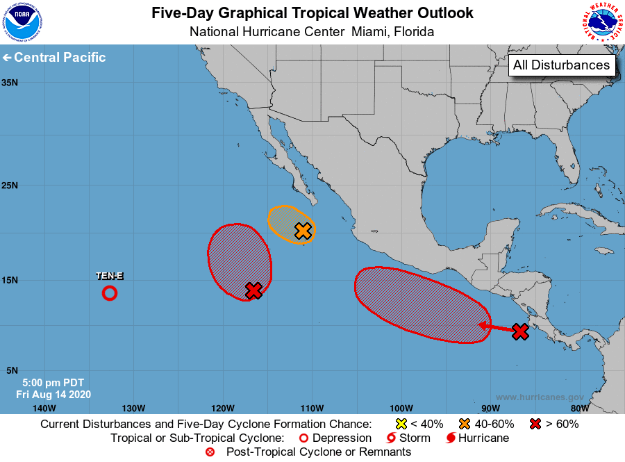
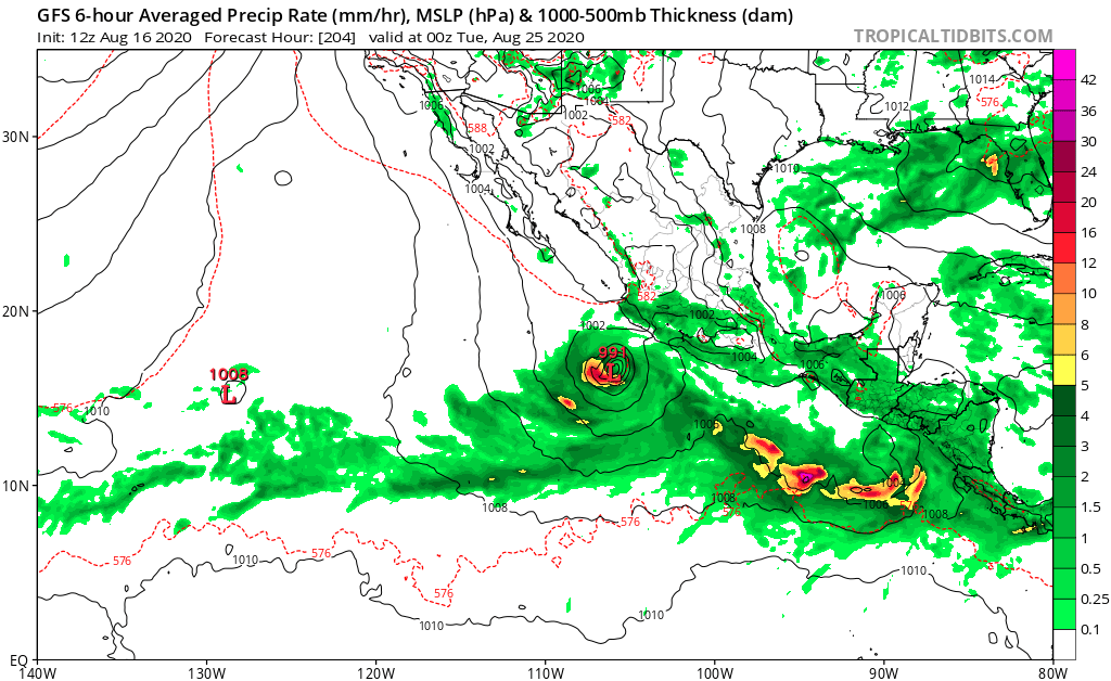
Would love to see a major hurricane fish but if it manages to stay off of the Mexico coastline. But it's going to be traversing the same region where Cristina and Elida struggled -- mainly due to dry air. So i'll have reservations on just how strong it will get.
3 likes   
RIP Kobe Bryant

User avatar
aspen
Category 5
Category 5
Posts: 8818
Joined: Sat Oct 12, 2019 7:10 pm
Location: Connecticut, USA

Re: 2020 EPAC Season

#702 Postby aspen » Thu Aug 13, 2020 5:10 pm

The 18z GFS has the 20/70 AOI form in the next 48-60 hours and stay a little further off the coast, which allows it to become a major in only 5 days.
0 likes   
Irene '11 Sandy '12 Hermine '16 5/15/2018 Derecho Fay '20 Isaias '20 Elsa '21 Henri '21 Ida '21

I am only a meteorology enthusiast who knows a decent amount about tropical cyclones. Look to the professional mets, the NHC, or your local weather office for the best information.

User avatar
cycloneye
Admin
Admin
Posts: 145301
Age: 68
Joined: Thu Oct 10, 2002 10:54 am
Location: San Juan, Puerto Rico

Re: 2020 EPAC Season

#703 Postby cycloneye » Thu Aug 13, 2020 6:23 pm

A trough of low pressure is located just offshore the Pacific
coast of Central America. Conditions are expected to be conducive
for a low to develop from this trough over the next couple of days,
and and a tropical depression is likely to form this weekend or
early next week while the system moves generally west-northwestward
just offshore of the southwestern coast of Mexico.
* Formation chance through 48 hours...low...30 percent.
* Formation chance through 5 days...high...80 percent.
0 likes   
Visit the Caribbean-Central America Weather Thread where you can find at first post web cams,radars
and observations from Caribbean basin members Click Here

User avatar
Extratropical94
Professional-Met
Professional-Met
Posts: 3538
Age: 30
Joined: Wed Oct 20, 2010 6:36 am
Location: Hamburg, Germany
Contact:

Re: 2020 EPAC Season

#704 Postby Extratropical94 » Fri Aug 14, 2020 12:36 am

No change at 11pm

A trough of low pressure is located just offshore of the Pacific
coast of Central America. Conditions are expected to be conducive
for a low pressure system to develop from this trough over the next
couple of days, and a tropical depression is likely to form this
weekend or early next week while the system moves generally
west-northwestward just offshore of the southwestern coast of
Mexico.
* Formation chance through 48 hours...low...30 percent.
* Formation chance through 5 days...high...80 percent.
0 likes   
54° 11' 59'' N, 9° 9' 20'' E
Boomer Sooner!
Go Broncos! Go Cards! Go Niners!
- Daniel

User avatar
cycloneye
Admin
Admin
Posts: 145301
Age: 68
Joined: Thu Oct 10, 2002 10:54 am
Location: San Juan, Puerto Rico

Re: 2020 EPAC Season

#705 Postby cycloneye » Fri Aug 14, 2020 6:43 am

The southwestern portion of the aforementioned trough is also
producing a large are of disturbed weather nearly 1000 miles
southwest of the southern tip of the Baja California peninsula.
Environmental conditions are expected to be favorable for the
development of this system and it could become a tropical depression
while it moves slowly northward during the next few days. after that
time.
* Formation chance through 48 hours...medium...50 percent.
* Formation chance through 5 days...medium...60 percent.


A trough of low pressure is producing disorganized showers and
thunderstorms just offshore of the Pacific coast of Central America.
Conditions are expected to be conducive for a low pressure system
to develop from this trough over the next couple of days, and a
tropical depression is likely to form this weekend or early next
week while the system moves generally west-northwestward just
offshore of the southwestern coast of Mexico.
* Formation chance through 48 hours...medium...40 percent.
* Formation chance through 5 days...high...80 percent.
0 likes   
Visit the Caribbean-Central America Weather Thread where you can find at first post web cams,radars
and observations from Caribbean basin members Click Here

User avatar
cycloneye
Admin
Admin
Posts: 145301
Age: 68
Joined: Thu Oct 10, 2002 10:54 am
Location: San Juan, Puerto Rico

Re: 2020 EPAC Season

#706 Postby cycloneye » Fri Aug 14, 2020 12:47 pm

3. A trough of low pressure continues to produce disorganized
showers and thunderstorms just offshore of the Pacific coast of
Central America. Conditions are expected to be conducive for a low
pressure system to develop from this trough over the next couple of
days, and a tropical depression is likely to form this weekend or
early next week while the system moves generally west-northwestward
just offshore of the southwestern coast of Mexico.
* Formation chance through 48 hours...medium...50 percent.
* Formation chance through 5 days...high...80 percent.
0 likes   
Visit the Caribbean-Central America Weather Thread where you can find at first post web cams,radars
and observations from Caribbean basin members Click Here

User avatar
cycloneye
Admin
Admin
Posts: 145301
Age: 68
Joined: Thu Oct 10, 2002 10:54 am
Location: San Juan, Puerto Rico

Re: 2020 EPAC Season

#707 Postby cycloneye » Fri Aug 14, 2020 6:24 pm

70%/90%

A trough of low pressure continues to produce disorganized
showers and thunderstorms just offshore of the Pacific coast of
Central America. Conditions are expected to be conducive for a low
pressure system to develop from this trough over the next day or
so, and a tropical depression or storm is likely to form this
weekend or early next week while the system moves generally
west-northwestward just offshore of the southwestern coast of
Mexico.
* Formation chance through 48 hours...high...70 percent.
* Formation chance through 5 days...high...90 percent.
0 likes   
Visit the Caribbean-Central America Weather Thread where you can find at first post web cams,radars
and observations from Caribbean basin members Click Here

User avatar
gatorcane
S2K Supporter
S2K Supporter
Posts: 23691
Age: 47
Joined: Sun Mar 13, 2005 3:54 pm
Location: Boca Raton, FL

Re: 2020 EPAC Season

#708 Postby gatorcane » Fri Aug 14, 2020 7:33 pm

Quite active:

Image
0 likes   

User avatar
CyclonicFury
Category 5
Category 5
Posts: 2025
Age: 26
Joined: Sun Jul 02, 2017 12:32 pm
Location: NC
Contact:

Re: 2020 EPAC Season

#709 Postby CyclonicFury » Fri Aug 14, 2020 7:36 pm

Despite the strong MJO pulse and TC outbreak, none of the TCs so far have developed into classic longtrackers from this MJO event. This isn't 2014, 2015 or 2018. The EPAC will likely quiet down late this month as the MJO propagates eastward.
9 likes   
NCSU B.S. in Meteorology Class of 2021. Tropical weather blogger at http://www.cyclonicfury.com. My forecasts and thoughts are NOT official, for official forecasts please consult the National Hurricane Center.

User avatar
Kingarabian
S2K Supporter
S2K Supporter
Posts: 15980
Joined: Sat Aug 08, 2009 3:06 am
Location: Honolulu, Hawaii

Re: 2020 EPAC Season

#710 Postby Kingarabian » Sat Aug 15, 2020 3:18 am

CyclonicFury wrote:Despite the strong MJO pulse and TC outbreak, none of the TCs so far have developed into classic longtrackers from this MJO event. This isn't 2014, 2015 or 2018. The EPAC will likely quiet down late this month as the MJO propagates eastward.

Don't forget 2016 and 2017. They boith had respectable long trackers and bursts of activity despite being cool neutral/La Nina year.

The 2014-2018 EPAC era probably generated the most EPAC ACE on record.
0 likes   
RIP Kobe Bryant

User avatar
gatorcane
S2K Supporter
S2K Supporter
Posts: 23691
Age: 47
Joined: Sun Mar 13, 2005 3:54 pm
Location: Boca Raton, FL

Re: 2020 EPAC Season

#711 Postby gatorcane » Sat Aug 15, 2020 6:48 am

The GFS insists the EPAC will stay active:

Image
0 likes   

User avatar
gatorcane
S2K Supporter
S2K Supporter
Posts: 23691
Age: 47
Joined: Sun Mar 13, 2005 3:54 pm
Location: Boca Raton, FL

Re: 2020 EPAC Season

#712 Postby gatorcane » Sat Aug 15, 2020 9:37 am

The GFS parallel ensembles with some weak activity in the EPAC:

Image
Last edited by gatorcane on Sat Aug 15, 2020 9:48 am, edited 2 times in total.
0 likes   

User avatar
aspen
Category 5
Category 5
Posts: 8818
Joined: Sat Oct 12, 2019 7:10 pm
Location: Connecticut, USA

Re: 2020 EPAC Season

#713 Postby aspen » Sat Aug 15, 2020 9:40 am

gatorcane wrote:The GFS parallel has another major hurricane in the EPAC following in the wake of 95E:

https://i.postimg.cc/J0rXYm5v/gfsp-mslp-pcpn-epac-44.png

The GFS-Para hasn’t had an updated run in five days; the most recent run is from August 10th.
2 likes   
Irene '11 Sandy '12 Hermine '16 5/15/2018 Derecho Fay '20 Isaias '20 Elsa '21 Henri '21 Ida '21

I am only a meteorology enthusiast who knows a decent amount about tropical cyclones. Look to the professional mets, the NHC, or your local weather office for the best information.

User avatar
gatorcane
S2K Supporter
S2K Supporter
Posts: 23691
Age: 47
Joined: Sun Mar 13, 2005 3:54 pm
Location: Boca Raton, FL

Re: 2020 EPAC Season

#714 Postby gatorcane » Sat Aug 15, 2020 9:49 am

aspen wrote:
gatorcane wrote:The GFS parallel has another major hurricane in the EPAC following in the wake of 95E:

https://i.postimg.cc/J0rXYm5v/gfsp-mslp-pcpn-epac-44.png

The GFS-Para hasn’t had an updated run in five days; the most recent run is from August 10th.


Thanks for pointing this out. I removed that image and replaced with the GFS parallel ensembles.
0 likes   

User avatar
NDG
S2K Supporter
S2K Supporter
Posts: 15446
Joined: Sun Jul 09, 2006 10:14 pm
Location: Orlando, FL

Re: 2020 EPAC Season

#715 Postby NDG » Sat Aug 15, 2020 10:50 am

gatorcane wrote:The GFS insists the EPAC will stay active:

https://i.postimg.cc/tgNfHMDG/gfs-mslp-pcpn-epac-41.png


That's probably because the GFS is erroneously retrograding the MJO back to the EPAC side as Michael Ventrice pointed that out.
The GEFS-Para is less aggressive on the EPAC and more aggressive on the Atlantic side on its long range forecast compared to the GFS & GEFS.
3 likes   

User avatar
gatorcane
S2K Supporter
S2K Supporter
Posts: 23691
Age: 47
Joined: Sun Mar 13, 2005 3:54 pm
Location: Boca Raton, FL

Re: 2020 EPAC Season

#716 Postby gatorcane » Sat Aug 15, 2020 12:12 pm

NDG wrote:
gatorcane wrote:The GFS insists the EPAC will stay active:

https://i.postimg.cc/tgNfHMDG/gfs-mslp-pcpn-epac-41.png


That's probably because the GFS is erroneously retrograding the MJO back to the EPAC side as Michael Ventrice pointed that out.
The GEFS-Para is less aggressive on the EPAC and more aggressive on the Atlantic side on its long range forecast compared to the GFS & GEFS.


Yes I saw Michael’s post. If the GFS is not correctly handling the MJO then yes it is just spinning up phantoms. Latest 12Z GFS run still has not given up on the EPAC:

Image
0 likes   

User avatar
CyclonicFury
Category 5
Category 5
Posts: 2025
Age: 26
Joined: Sun Jul 02, 2017 12:32 pm
Location: NC
Contact:

Re: 2020 EPAC Season

#717 Postby CyclonicFury » Sat Aug 15, 2020 9:43 pm

This "hyperactive period" will be lucky to produce 10 ACE.
8 likes   
NCSU B.S. in Meteorology Class of 2021. Tropical weather blogger at http://www.cyclonicfury.com. My forecasts and thoughts are NOT official, for official forecasts please consult the National Hurricane Center.

MarioProtVI
Category 4
Category 4
Posts: 935
Age: 24
Joined: Sun Sep 29, 2019 7:33 pm
Location: New Jersey

Re: 2020 EPAC Season

#718 Postby MarioProtVI » Sat Aug 15, 2020 9:59 pm

Really wish Avila was still at NHC so he could do 11E’s advisory and the state of the EPac right now. It’d be hilarious :lol: :lol: :lol:
9 likes   

User avatar
gatorcane
S2K Supporter
S2K Supporter
Posts: 23691
Age: 47
Joined: Sun Mar 13, 2005 3:54 pm
Location: Boca Raton, FL

Re: 2020 EPAC Season

#719 Postby gatorcane » Sun Aug 16, 2020 11:33 am

The GFS is trending a stronger with yet another storm behind TD 12. Timeframe is coming in each run (development actually starts around 168 hours):

Image
Last edited by gatorcane on Sun Aug 16, 2020 11:41 am, edited 1 time in total.
0 likes   

User avatar
Yellow Evan
Professional-Met
Professional-Met
Posts: 16143
Age: 27
Joined: Fri Jul 15, 2011 12:48 pm
Location: Henderson, Nevada/Honolulu, HI
Contact:

Re: 2020 EPAC Season

#720 Postby Yellow Evan » Sun Aug 16, 2020 11:41 am

GFS is keeping the MJO in the basin for too long. Disregard.
4 likes   


Return to “Talkin' Tropics”

Who is online

Users browsing this forum: Google Adsense [Bot], SconnieCane and 40 guests