2025 Global Model Runs Discussion (Out thru day 16)
Moderator: S2k Moderators
Forum rules

The posts in this forum are NOT official forecasts and should not be used as such. They are just the opinion of the poster and may or may not be backed by sound meteorological data. They are NOT endorsed by any professional institution or STORM2K. For official information, please refer to products from the National Hurricane Center and National Weather Service.
-
hurricane2025
- Category 1

- Posts: 254
- Joined: Thu Apr 08, 2021 10:36 am
Re: 2025 Global Model Runs Discussion (Out thru day 16)
Ridge breaks but this isn’t October or late Sept
0 likes

Re: 2025 Global Model Runs Discussion (Out thru day 16)
Tampa Bay surge monster on this run, lol
0 likes
Igor 2010, Sandy 2012, Fay 2014, Gonzalo 2014, Joaquin 2015, Nicole 2016, Humberto 2019, Imelda 2025
I am only a tropical weather enthusiast. My predictions are not official and may or may not be backed by sound meteorological data. For official information, please refer to the NHC and NWS products.
I am only a tropical weather enthusiast. My predictions are not official and may or may not be backed by sound meteorological data. For official information, please refer to the NHC and NWS products.

Re: 2025 Global Model Runs Discussion (Out thru day 16)
Tracks on the operational models this far out don’t matter. They will change by sometimes a thousand miles from run to run.
1 likes
-
Stratton23
- Category 5

- Posts: 3574
- Joined: Fri Jul 21, 2023 10:59 pm
- Location: Katy, Tx
Re: 2025 Global Model Runs Discussion (Out thru day 16)
This looks like a potential storm on land stall out on the GFS run, storm beds slightly west south of tallahasse , but ridging rebuilds over the top of this, storm slowing down on this run
0 likes
Re: 2025 Global Model Runs Discussion (Out thru day 16)
12z GFS winds up near Destin. Range for the last couple days is basically Georgia east coast to Texas. This one is kinda in the middle of those.

0 likes
-
hurricane2025
- Category 1
- Posts: 254
- Joined: Thu Apr 08, 2021 10:36 am
Re: 2025 Global Model Runs Discussion (Out thru day 16)
Stratton23 wrote:This looks like a potential storm on land stall out on the GFS run, storm beds slightly west south of tallahasse , but ridging rebuilds over the top of this, storm slowing down on this run
Trough way to strong on gfs it isn’t going to dig that deep
0 likes
-
gatorcane

- S2K Supporter

- Posts: 23708
- Age: 48
- Joined: Sun Mar 13, 2005 3:54 pm
- Location: Boca Raton, FL
Re: 2025 Global Model Runs Discussion (Out thru day 16)
Looks like the long-range Euro AI model busted big-time in the long-range with Erin moving west impacting Florida and then the Gulf or being in the vicinity of. It did, however, accurately predict a significant hurricane forming in the long-range. Modelling has a long way to go predicting not only genesis but track especially once you get beyond 168 hours (a week) and especially over 200. There is a reason why the NHC forecast and outlooks only go out 7 days. That being said, as we see just about every year, we can expect more major hurricane landfall hits for Florida in the long-range forecasts especially by the GFS (who some here call the "Giving Florida Storms" model). It's when we get within 180 hours and especially within 168 hours with the modeling that can be more concerning. The track can shift even for a 3-day forecast or up to the day of landfall.
0 likes
-
cheezyWXguy

- Category 5
- Posts: 6282
- Joined: Mon Feb 13, 2006 12:29 am
- Location: Dallas, TX
Re: 2025 Global Model Runs Discussion (Out thru day 16)
gatorcane wrote:Looks like the long-range Euro AI model and GFS busted big-time in the long-range with Erin moving west impacting Florida and then the Gulf or being in the vicinity of. They did, however, accurately predict a significant hurricane forming in the long-range. Modelling has a long way to go predicting not only genesis but track especially once you get beyond 168 hours (a week) and especially over 200. There is a reason why the NHC forecast and outlooks only go out 7 days. That being said, as we see just about every year, we can expect more major hurricane landfall hits for Florida in the long-range forecasts especially by the GFS (who some here call the "Giving Florida Storms" model). It's when we get within 180 hours and especially within 168 hours with the modeling that can be more concerning. Even then sometimes the track can shift within a 3-day forecast even up to the day of landfall.
I hope no one on here is getting too emotionally invested in landfall points for this system as of now, for specifically the reasons you mention. Main themes at this point are that the chances of storm formation look to be going up, and that formation looks to occur in an area where the likelihood of land impacts for someone is notably higher. Anything more specific or farther out in time is hardly more than entertainment value at this time. Those who live on hurricane prone coastlines should be getting prepared, if for no other reason than that we are in the climatologically favored period where storms like this can occur. Otherwise, plenty of time to watch the model wars.
3 likes
-
TampaWxLurker
- Tropical Storm

- Posts: 196
- Joined: Thu Aug 01, 2024 8:20 am
Re: 2025 Global Model Runs Discussion (Out thru day 16)
Anyone know if the 12z Euro developed anything?
0 likes
-
Kingarabian

- S2K Supporter
- Posts: 16379
- Joined: Sat Aug 08, 2009 3:06 am
- Location: Honolulu, Hawaii
Re: 2025 Global Model Runs Discussion (Out thru day 16)
TampaWxLurker wrote:Anyone know if the 12z Euro developed anything?
Runs in 30 minutes and will be about an hour before it begins to show development (IF).
1 likes
RIP Kobe Bryant
Re: 2025 Global Model Runs Discussion (Out thru day 16)
TampaWxLurker wrote:Anyone know if the 12z Euro developed anything?
0Z eventually developed it off the EC late in its run. Before it just had an open wave.
0 likes

Re: 2025 Global Model Runs Discussion (Out thru day 16)
The funny thing is that the Euro suite, both operational and ensembles, were more enthusiastic about this system than GFS was a few days ago. Then Euro's support went down just when GFS/GEFS picked it up.
Euro 12z 8/11 (5 days ago): (Yes, 360 hrs out, but...)
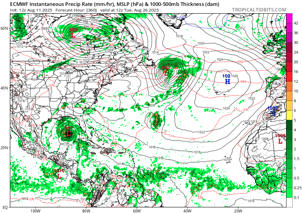
Euro 12z 8/11 (5 days ago): (Yes, 360 hrs out, but...)
3 likes
TC naming lists: retirements and intensity
Most aggressive Advisory #1's in North Atlantic (cr. kevin for starting the list)
Most aggressive Advisory #1's in North Atlantic (cr. kevin for starting the list)
-
USTropics
- Professional-Met

- Posts: 2739
- Joined: Sun Aug 12, 2007 3:45 am
- Location: Florida State University
Re: 2025 Global Model Runs Discussion (Out thru day 16)
Kingarabian wrote:TampaWxLurker wrote:Anyone know if the 12z Euro developed anything?
Runs in 30 minutes and will be about an hour before it begins to show development (IF).
It runs sooner on pivotal:
https://www.pivotalweather.com/model.php?m=ecmwf_full&p=sfcwind_mslp&rh=2025081612&fh=144&r=atl&dpdt=&mc=
The last 2 runs its had more of a reflection at the surface but still not showing much development. Here is the latest 12z run at 120 hours:

2 likes
-
Stratton23
- Category 5
- Posts: 3574
- Joined: Fri Jul 21, 2023 10:59 pm
- Location: Katy, Tx
Re: 2025 Global Model Runs Discussion (Out thru day 16)
Euro no development yet, but it definitely is trending towards development
Last edited by Stratton23 on Sat Aug 16, 2025 1:17 pm, edited 1 time in total.
0 likes
-
DunedinDave
- Category 1
- Posts: 269
- Joined: Fri Aug 25, 2023 10:31 am
Re: 2025 Global Model Runs Discussion (Out thru day 16)
I sure as heck hope the GFS is starting happy hour early today. That’s a nightmare scenario for Florida in 10 days.
1 likes
-
StPeteMike

- Category 2

- Posts: 657
- Joined: Thu Jun 07, 2018 11:26 pm
Re: 2025 Global Model Runs Discussion (Out thru day 16)
A weaker system until the Caribbean would be bad for obvious reasons. The rest of the runs pretty much kills off this system.
I don’t believe the runs, especially when the atmosphere isn’t too hostile for development in the MDR. I could see development taking its time until 50W, kind of like Erin, but I don’t put much belief that nothing will develop in the next 2 weeks.
I don’t believe the runs, especially when the atmosphere isn’t too hostile for development in the MDR. I could see development taking its time until 50W, kind of like Erin, but I don’t put much belief that nothing will develop in the next 2 weeks.
1 likes
The above post is not official and should not be used as such. It is the opinion of the poster and may or may not be backed by sound meteorological data. It is not endorsed by any professional institution or storm2k.org. For official information, please refer to the NHC and NWS products.
-
USTropics
- Professional-Met
- Posts: 2739
- Joined: Sun Aug 12, 2007 3:45 am
- Location: Florida State University
Re: 2025 Global Model Runs Discussion (Out thru day 16)
After analyzing the 12z data, it appears the catalyst is this mesoscale convective system (MCS, green) associated with the monsoon trough (orange). This will interact with the northern quadrant of a tropical wave (teal) observed near the Cabo Verde islands in the next 24-48 hours:

In the CIMSS mid-level vorticity product, we can easily track this MCS's path from a few days ago along the monsoon trough track as well as the vorticity associated with the tropical wave:

Highlighting these two features again, it's uncertain if the northern or southern vorticity will develop. These two features can tug on one another, rotate around each other, one absorbs the other, etc. It's a hard process for models to solve:

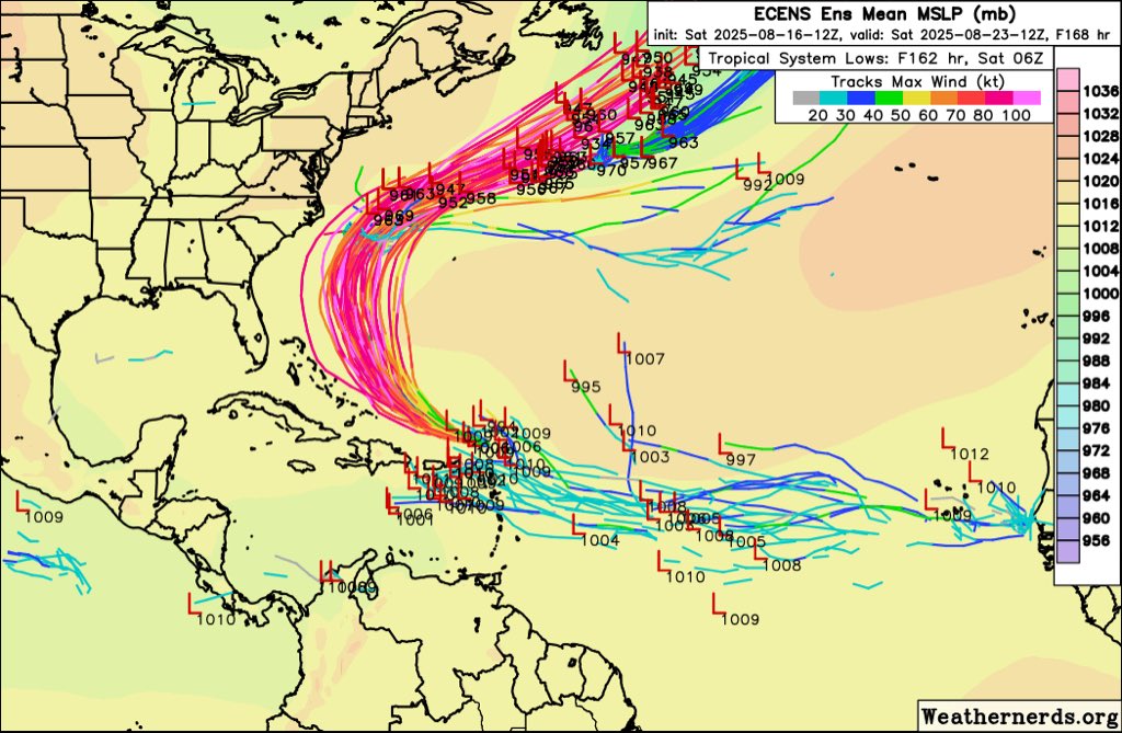
Here are the latest 12z GFS ensembles out to 186 hours, and there are noticeably two camps (a northern and southern):

The 06z ECMWF ensembles show a similar possibility:

I'll outline one possibility, the GFS. The model forecasts that these two vorticity maxima will rotate around each other over the next ~3 days. Picking up from the initial CIMSS vorticity analysis above, the GFS actually develops the area in purple:

We can see at 24 hours, the first rotation has essentially occurred:

Going out to 48 hours (24 hour timestep), the pink area (initial MCS) is acting as the 'shield' to moisten the environment out in front of the tropical wave:

At 72 hours, the 12z GFS operational has a pivotal moment where the MCS is finally absorbed, and this is when the model starts to show more development (with a tropical cyclone 36 hours later):

Full animation out to 240 hours:

https://cyclonicwx.com/models/gfs/atl/v700/2025081612/000/
In the CIMSS mid-level vorticity product, we can easily track this MCS's path from a few days ago along the monsoon trough track as well as the vorticity associated with the tropical wave:
Highlighting these two features again, it's uncertain if the northern or southern vorticity will develop. These two features can tug on one another, rotate around each other, one absorbs the other, etc. It's a hard process for models to solve:
Here are the latest 12z GFS ensembles out to 186 hours, and there are noticeably two camps (a northern and southern):
The 06z ECMWF ensembles show a similar possibility:
I'll outline one possibility, the GFS. The model forecasts that these two vorticity maxima will rotate around each other over the next ~3 days. Picking up from the initial CIMSS vorticity analysis above, the GFS actually develops the area in purple:
We can see at 24 hours, the first rotation has essentially occurred:
Going out to 48 hours (24 hour timestep), the pink area (initial MCS) is acting as the 'shield' to moisten the environment out in front of the tropical wave:
At 72 hours, the 12z GFS operational has a pivotal moment where the MCS is finally absorbed, and this is when the model starts to show more development (with a tropical cyclone 36 hours later):
Full animation out to 240 hours:
https://cyclonicwx.com/models/gfs/atl/v700/2025081612/000/
16 likes
Re: 2025 Global Model Runs Discussion (Out thru day 16)
BobHarlem wrote:12z GFS winds up near Destin. Range for the last couple days is basically Georgia east coast to Texas. This one is kinda in the middle of those.
https://i.imgur.com/reWBygL.png
This series of GFS runs is brought to you by Anco Wipers
3 likes
-
Hurrilurker

- Category 2
- Posts: 738
- Joined: Mon Jun 09, 2003 3:32 pm
- Location: San Francisco, CA
Re: 2025 Global Model Runs Discussion (Out thru day 16)
^ Fascinating analysis, thank you, very interesting to see the 2 centers rotate around each other, you can actually see it in the animation even before it pops. The long-range result looks bad, but if that goes a little more north or a little more south (avoiding the Hispaniola shredder) it could be even worse.
0 likes
-
SFLcane

- S2K Supporter
- Posts: 10281
- Age: 48
- Joined: Sat Jun 05, 2010 1:44 pm
- Location: Lake Worth Florida
Re: 2025 Global Model Runs Discussion (Out thru day 16)
Fairly healthy signal from eps also for some development of this wave.
1 likes
Who is online
Users browsing this forum: No registered users and 213 guests