Broad area of disturbed weather in the Western Caribbean Sea (Is INVEST 91L)

This is the general tropical discussion area. Anyone can take their shot at predicting a storms path.

Moderator: S2k Moderators

Forum rules

The posts in this forum are NOT official forecasts and should not be used as such. They are just the opinion of the poster and may or may not be backed by sound meteorological data. They are NOT endorsed by any professional institution or STORM2K. For official information, please refer to products from the National Hurricane Center and National Weather Service.

Help Support Storm2K
Message
Author
User avatar
p1nheadlarry
Category 2
Category 2
Posts: 672
Age: 33
Joined: Wed Jan 29, 2014 2:42 pm
Location: SR County FL

Re: Broad area of disturbed weather in the Western Caribbean Sea

#721 Postby p1nheadlarry » Thu Oct 04, 2018 10:15 pm

LarryWx wrote:More on the 51 member 0Z EPS, which was much more active than any earlier run, along with Oct. 1-10 genesis climo:

13 H landfalls on FL (in addition to several TS hits):
- 5 Panhandle
- 5 Apalachicola to N of Tampa (includes Big Bend)
- 2 Tampa-Sarasota area
- 1 south tip


Not to be ignored, it also has 3 landfalls on LA (in addition to 2 TSs):
- 1 LA/MS border on 10/10
- 1 W LA 10/13
- 1 central LA 10/15


Tracks of TC with genesis 10/1-10 1851-2015:
https://www.nhc.noaa.gov/climo/images/oct_1_10.png

Favors a NE mover over FL but a significant 2nd max (just like the 0Z EPS has) moving N to NE over LA, especially central and eastern LA.


OT but I'll be the guy. Nobody in Florida calls Apalachicola the Big Bend. Everything west and including Jefferson CO is the Panhandle, the rest the peninsula.
0 likes   
--;->#GoNoles--;->.

Dean4Storms
S2K Supporter
S2K Supporter
Posts: 6358
Age: 62
Joined: Sun Aug 31, 2003 1:01 pm
Location: Miramar Bch. FL

Re: Broad area of disturbed weather in the Western Caribbean Sea

#722 Postby Dean4Storms » Thu Oct 04, 2018 10:15 pm

I’m now perplexed that this isn’t an Invest yet. :roll:
0 likes   

floridasun78
Category 5
Category 5
Posts: 3755
Joined: Sun May 17, 2009 10:16 pm
Location: miami fl

Re: Broad area of disturbed weather in the Western Caribbean Sea

#723 Postby floridasun78 » Thu Oct 04, 2018 10:26 pm

Dean4Storms wrote:I’m now perplexed that this isn’t an Invest yet. :roll:
no invest because low is weak now off coast and storm are not organizing yet nhc dont invest by models only their look sat pic other data we likely see invest sat or sunday like some here been saying
Last edited by floridasun78 on Thu Oct 04, 2018 10:44 pm, edited 1 time in total.
0 likes   

User avatar
AnnularCane
S2K Supporter
S2K Supporter
Posts: 2860
Joined: Thu Jun 08, 2006 9:18 am
Location: Wytheville, VA

Re: Broad area of disturbed weather in the Western Caribbean Sea

#724 Postby AnnularCane » Thu Oct 04, 2018 10:42 pm

Dean4Storms wrote:I’m now perplexed that this isn’t an Invest yet. :roll:


Invest declaration has taken forever this year for some reason.
0 likes   

floridasun78
Category 5
Category 5
Posts: 3755
Joined: Sun May 17, 2009 10:16 pm
Location: miami fl

Re: Broad area of disturbed weather in the Western Caribbean Sea

#725 Postby floridasun78 » Thu Oct 04, 2018 10:46 pm

AnnularCane wrote:
Dean4Storms wrote:I’m now perplexed that this isn’t an Invest yet. :roll:


Invest declaration has taken forever this year for some reason.
not thing organizing yet yes low by coast down their but enough be invest yet
0 likes   

caneman
Category 5
Category 5
Posts: 1447
Joined: Fri Sep 05, 2014 5:44 am
Location: Clearwater Beach, Fl

Re: Broad area of disturbed weather in the Western Caribbean Sea

#726 Postby caneman » Thu Oct 04, 2018 10:50 pm

p1nheadlarry wrote:
LarryWx wrote:More on the 51 member 0Z EPS, which was much more active than any earlier run, along with Oct. 1-10 genesis climo:

13 H landfalls on FL (in addition to several TS hits):
- 5 Panhandle
- 5 Apalachicola to N of Tampa (includes Big Bend)
- 2 Tampa-Sarasota area
- 1 south tip


Not to be ignored, it also has 3 landfalls on LA (in addition to 2 TSs):
- 1 LA/MS border on 10/10
- 1 W LA 10/13
- 1 central LA 10/15


Tracks of TC with genesis 10/1-10 1851-2015:
https://www.nhc.noaa.gov/climo/images/oct_1_10.png

Favors a NE mover over FL but a significant 2nd max (just like the 0Z EPS has) moving N to NE over LA, especially central and eastern LA.


OT but I'll be the guy. Nobody in Florida calls Apalachicola the Big Bend. Everything west and including Jefferson CO is the Panhandle, the rest the peninsula.


Matter or preference maybe but I and many others have always classified Appalach. as the northern part of the big bend.
0 likes   

User avatar
Hammy
Category 5
Category 5
Posts: 5849
Age: 41
Joined: Fri May 25, 2012 5:25 pm
Contact:

Re: Broad area of disturbed weather in the Western Caribbean Sea

#727 Postby Hammy » Thu Oct 04, 2018 10:50 pm

floridasun78 wrote:
AnnularCane wrote:
Dean4Storms wrote:I’m now perplexed that this isn’t an Invest yet. :roll:


Invest declaration has taken forever this year for some reason.
not thing organizing yet yes low by coast down their but enough be invest yet


There's something like three or four low pressures down there--they're probably trying to see which one takes hold since that'll determine what it does.
0 likes   
The above post is not official and should not be used as such. It is the opinion of the poster and may or may not be backed by sound meteorological data. It is not endorsed by any professional institution or storm2k.org. For official information, please refer to the NHC and NWS products.

LarryWx
S2K Supporter
S2K Supporter
Posts: 6300
Joined: Sun Sep 07, 2003 2:04 pm
Location: GA

Re: Broad area of disturbed weather in the Western Caribbean Sea

#728 Postby LarryWx » Thu Oct 04, 2018 11:29 pm

0Z UKMET FL panhandle into SE AL and then west central GA: way right of 24 hours ago; nearly identical to 0Z CMC; pressure at hour 144 of 979 mb looks funky since that's well inland

NEW TROPICAL CYCLONE FORECAST TO DEVELOP AFTER 36 HOURS
FORECAST POSITION AT T+ 36 : 17.9N 86.9W

LEAD CENTRAL MAXIMUM WIND
VERIFYING TIME TIME POSITION PRESSURE (MB) SPEED (KNOTS)
-------------- ---- -------- ------------- -------------
1200UTC 06.10.2018 36 17.9N 86.9W 1005 27
0000UTC 07.10.2018 48 18.7N 86.5W 1005 27
1200UTC 07.10.2018 60 19.9N 87.2W 1003 35
0000UTC 08.10.2018 72 20.3N 87.1W 1001 34
1200UTC 08.10.2018 84 21.6N 88.4W 1001 35
0000UTC 09.10.2018 96 22.4N 88.4W 1000 33
1200UTC 09.10.2018 108 23.9N 88.6W 999 37
0000UTC 10.10.2018 120 26.0N 88.3W 997 37
1200UTC 10.10.2018 132 28.9N 87.0W 990 49
0000UTC 11.10.2018 144 32.0N 85.2W 979 36
0 likes   
Personal Forecast Disclaimer:
The posts in this forum are NOT official forecasts and should not be used as such. They are just the opinion of the poster and may or may not be backed by sound meteorological data. They are NOT endorsed by any professional institution or storm2k.org. For official information, please refer to the NHC and NWS products.

LarryWx
S2K Supporter
S2K Supporter
Posts: 6300
Joined: Sun Sep 07, 2003 2:04 pm
Location: GA

Re: Broad area of disturbed weather in the Western Caribbean Sea

#729 Postby LarryWx » Fri Oct 05, 2018 12:10 am

JMA fwiw is still east of the consensus; 20N, 83W at hour 72; still weak
0 likes   
Personal Forecast Disclaimer:
The posts in this forum are NOT official forecasts and should not be used as such. They are just the opinion of the poster and may or may not be backed by sound meteorological data. They are NOT endorsed by any professional institution or storm2k.org. For official information, please refer to the NHC and NWS products.

LarryWx
S2K Supporter
S2K Supporter
Posts: 6300
Joined: Sun Sep 07, 2003 2:04 pm
Location: GA

Re: Broad area of disturbed weather in the Western Caribbean Sea

#730 Postby LarryWx » Fri Oct 05, 2018 12:29 am

0Z GEFS 21 members: still quite busy and much more active than GFS

FL: 7 TS+ hits 10/11-14; 4 H (2 Apalach., Pan City, Big Bend) 3 TS (Tampa, Pensacola, Big Bend)

AL: 1 H 10/11

E LA: 1 TS 10/13

E LA/MS: 1 H 10/16-7
0 likes   
Personal Forecast Disclaimer:
The posts in this forum are NOT official forecasts and should not be used as such. They are just the opinion of the poster and may or may not be backed by sound meteorological data. They are NOT endorsed by any professional institution or storm2k.org. For official information, please refer to the NHC and NWS products.

LarryWx
S2K Supporter
S2K Supporter
Posts: 6300
Joined: Sun Sep 07, 2003 2:04 pm
Location: GA

Re: Broad area of disturbed weather in the Western Caribbean Sea

#731 Postby LarryWx » Fri Oct 05, 2018 12:40 am

0Z FV3: H LA/MS border 10/9
0 likes   
Personal Forecast Disclaimer:
The posts in this forum are NOT official forecasts and should not be used as such. They are just the opinion of the poster and may or may not be backed by sound meteorological data. They are NOT endorsed by any professional institution or storm2k.org. For official information, please refer to the NHC and NWS products.

LarryWx
S2K Supporter
S2K Supporter
Posts: 6300
Joined: Sun Sep 07, 2003 2:04 pm
Location: GA

Re: Broad area of disturbed weather in the Western Caribbean Sea

#732 Postby LarryWx » Fri Oct 05, 2018 1:55 am

0Z Euro: TS landfall AL 10/13
0 likes   
Personal Forecast Disclaimer:
The posts in this forum are NOT official forecasts and should not be used as such. They are just the opinion of the poster and may or may not be backed by sound meteorological data. They are NOT endorsed by any professional institution or storm2k.org. For official information, please refer to the NHC and NWS products.

User avatar
AJC3
Admin
Admin
Posts: 3999
Age: 61
Joined: Tue Aug 31, 2004 7:04 pm
Location: Ballston Spa, New York
Contact:

Re: Broad area of disturbed weather in the Western Caribbean Sea

#733 Postby AJC3 » Fri Oct 05, 2018 2:19 am

LarryWx wrote:0Z Euro: TS landfall AL 10/13


Both the 00Z ECM and GFS have now trended toward a slowdown/stall scenario for at least 2-3 days, over the central, or east-central GOMEX. At this point, it's a massively uncertain forecast. Given the utter lack of continuity in the OP-model runs over the past week, I'd have no choice but to lean very heavily on the ensembles. and emphasize "LOW CONFIDENCE FORECAST" in any solution.
5 likes   

Aric Dunn
Category 5
Category 5
Posts: 21238
Age: 42
Joined: Sun Sep 19, 2004 9:58 pm
Location: Ready for the Chase.
Contact:

Re: Broad area of disturbed weather in the Western Caribbean Sea

#734 Postby Aric Dunn » Fri Oct 05, 2018 2:23 am

AJC3 wrote:
LarryWx wrote:0Z Euro: TS landfall AL 10/13


Both the 00Z ECM and GFS have now trended toward a slowdown/stall scenario for at least 2-3 days, over the central, or east-central GOMEX. At this point, it's a massively uncertain forecast. Given the utter lack of continuity in the OP-model runs over the past week, I'd have no choice but to lean very heavily on the ensembles. and emphasize "LOW CONFIDENCE FORECAST" in any solution.


lol.... my broken record self the past 2 days ...

and why I have been sticking to nothing past 24 to 48 hours.. :P
2 likes   
Note: If I make a post that is brief. Please refer back to previous posts for the analysis or reasoning. I do not re-write/qoute what my initial post said each time.
If there is nothing before... then just ask :)

Space & Atmospheric Physicist, Embry-Riddle Aeronautical University,
I believe the sky is falling...

User avatar
robbielyn
Category 5
Category 5
Posts: 1298
Joined: Wed May 07, 2003 9:45 am
Location: brooksville, fl

Re: Broad area of disturbed weather in the Western Caribbean Sea

#735 Postby robbielyn » Fri Oct 05, 2018 4:51 am

caneman wrote:
p1nheadlarry wrote:
LarryWx wrote:More on the 51 member 0Z EPS, which was much more active than any earlier run, along with Oct. 1-10 genesis climo:

13 H landfalls on FL (in addition to several TS hits):
- 5 Panhandle
- 5 Apalachicola to N of Tampa (includes Big Bend)
- 2 Tampa-Sarasota area
- 1 south tip


Not to be ignored, it also has 3 landfalls on LA (in addition to 2 TSs):
- 1 LA/MS border on 10/10
- 1 W LA 10/13
- 1 central LA 10/15


Tracks of TC with genesis 10/1-10 1851-2015:
https://www.nhc.noaa.gov/climo/images/oct_1_10.png

Favors a NE mover over FL but a significant 2nd max (just like the 0Z EPS has) moving N to NE over LA, especially central and eastern LA.


OT but I'll be the guy. Nobody in Florida calls Apalachicola the Big Bend. Everything west and including Jefferson CO is the Panhandle, the rest the peninsula.


Matter or preference maybe but I and many others have always classified Appalach. as the northern part of the big bend.
absolutely we call apalach points eastward to perry fl the big bend.
1 likes   
Robbielyn McCrary
I know just about enough to sound like I know what I'm talking about sometimes. But for your safety please follow the nhc for truly professional forecasting. :D

caneman
Category 5
Category 5
Posts: 1447
Joined: Fri Sep 05, 2014 5:44 am
Location: Clearwater Beach, Fl

Re: Broad area of disturbed weather in the Western Caribbean Sea

#736 Postby caneman » Fri Oct 05, 2018 4:57 am

Looks to be really firing some convection this morning. I too am shocked that this isn't yet labeled an invest. Maybe this morning
0 likes   

User avatar
N2FSU
S2K Supporter
S2K Supporter
Posts: 1062
Joined: Thu Sep 04, 2003 2:04 pm
Location: Tallahassee, FL

Re: Broad area of disturbed weather in the Western Caribbean Sea

#737 Postby N2FSU » Fri Oct 05, 2018 5:29 am

Big shift east for the UK:

Image
0 likes   

User avatar
N2FSU
S2K Supporter
S2K Supporter
Posts: 1062
Joined: Thu Sep 04, 2003 2:04 pm
Location: Tallahassee, FL

Re: Broad area of disturbed weather in the Western Caribbean Sea

#738 Postby N2FSU » Fri Oct 05, 2018 5:34 am

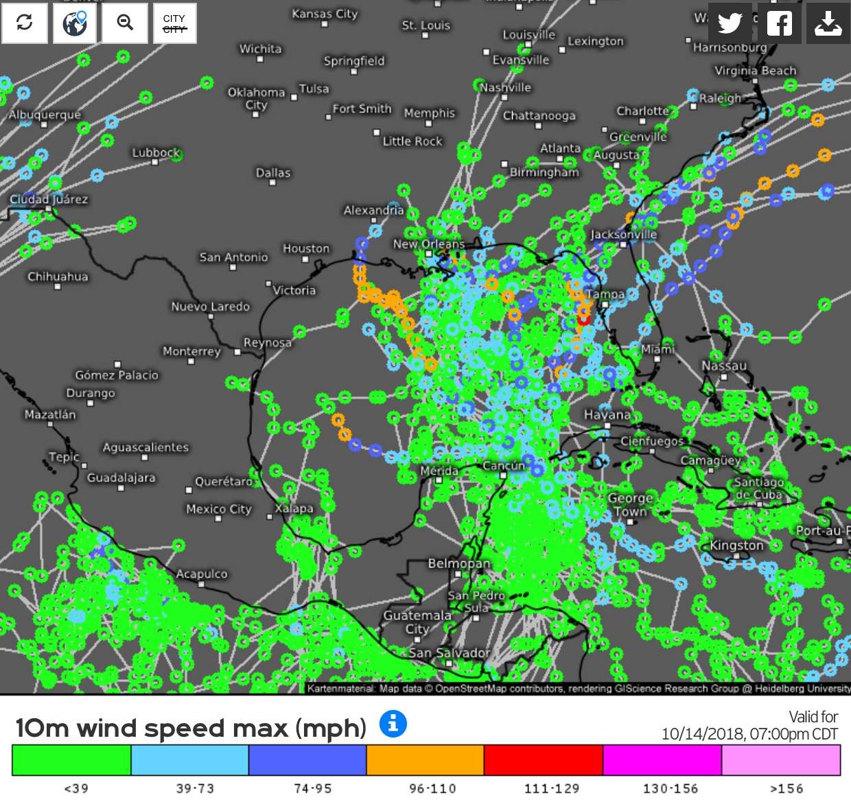
0z Euro ensembles

Image
0 likes   

Dean4Storms
S2K Supporter
S2K Supporter
Posts: 6358
Age: 62
Joined: Sun Aug 31, 2003 1:01 pm
Location: Miramar Bch. FL

Re: Broad area of disturbed weather in the Western Caribbean Sea

#739 Postby Dean4Storms » Fri Oct 05, 2018 5:39 am

N2FSU wrote:Big shift east for the UK:

https://imageshack.com/a/img924/3117/j1vIkW.jpg


Ha...right over my noggin!
0 likes   

User avatar
NDG
S2K Supporter
S2K Supporter
Posts: 15446
Joined: Sun Jul 09, 2006 10:14 pm
Location: Orlando, FL

Re: Broad area of disturbed weather in the Western Caribbean Sea

#740 Postby NDG » Fri Oct 05, 2018 5:47 am

A lot of mid level vortices rotating around the monsoonal gyre, including 97E.
Things usually take longer to consolidate with these big C.A. monsoonal lows and models always struggle with it, never fails. IMO.

Image
0 likes   


Return to “Talkin' Tropics”

Who is online

Users browsing this forum: HurricaneFan, riapal and 28 guests