2021 Indicators: SST's / SAL / MSLP / Shear / Steering / Instability / Sat Images

This is the general tropical discussion area. Anyone can take their shot at predicting a storms path.

Moderator: S2k Moderators

Forum rules

The posts in this forum are NOT official forecasts and should not be used as such. They are just the opinion of the poster and may or may not be backed by sound meteorological data. They are NOT endorsed by any professional institution or STORM2K. For official information, please refer to products from the National Hurricane Center and National Weather Service.

Help Support Storm2K
Message
Author
Shell Mound
Category 5
Category 5
Posts: 2434
Age: 32
Joined: Thu Sep 07, 2017 3:39 pm
Location: St. Petersburg, FL → Scandinavia

Re: 2021 Indicators: SST's / SAL / MSLP / Shear / Steering / Instability / Sat Images

#721 Postby Shell Mound » Sat Jun 12, 2021 11:13 am

JetFuel_SE wrote:
Shell Mound wrote:
CyclonicFury wrote:2018, which had a near-record cold MDR in May and June, had 4 hurricanes form in the MDR, while 2020, which had a near-record warm MDR at times, had only 1 hurricane form in the MDR. I don't think the cool MDR will be a huge negative factor this year because the tropical Pacific is likely to be even cooler. We've seen several -ENSO seasons with a cool MDR that were very active to hyperactive (1996 and 1999 are examples).

https://i.postimg.cc/RFSC8SYb/SST19969-1.png
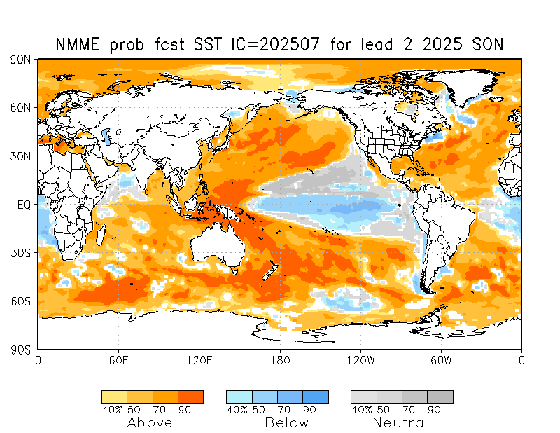
https://www.cpc.ncep.noaa.gov/products/NMME/prob/images/prob_ensemble_tmpsfc_season2.png
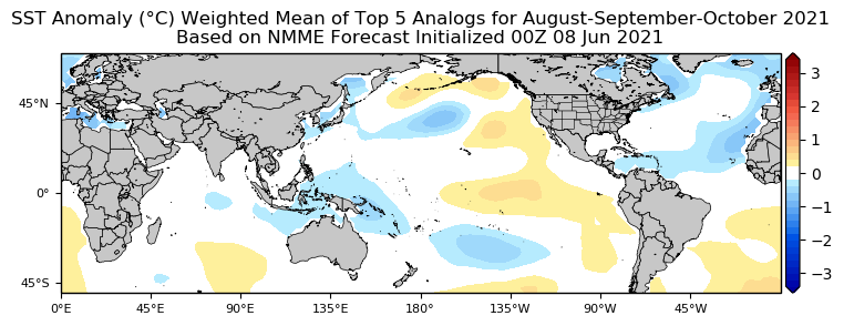
https://i.postimg.cc/T2Z1265h/Weighted-Analogs-1.png
Note: Last image is from Tropical Tidbits

Please remove that last image, it's using corrupted data, and isn't accurate. It's basing it off this thing, which is obviously not accurate.
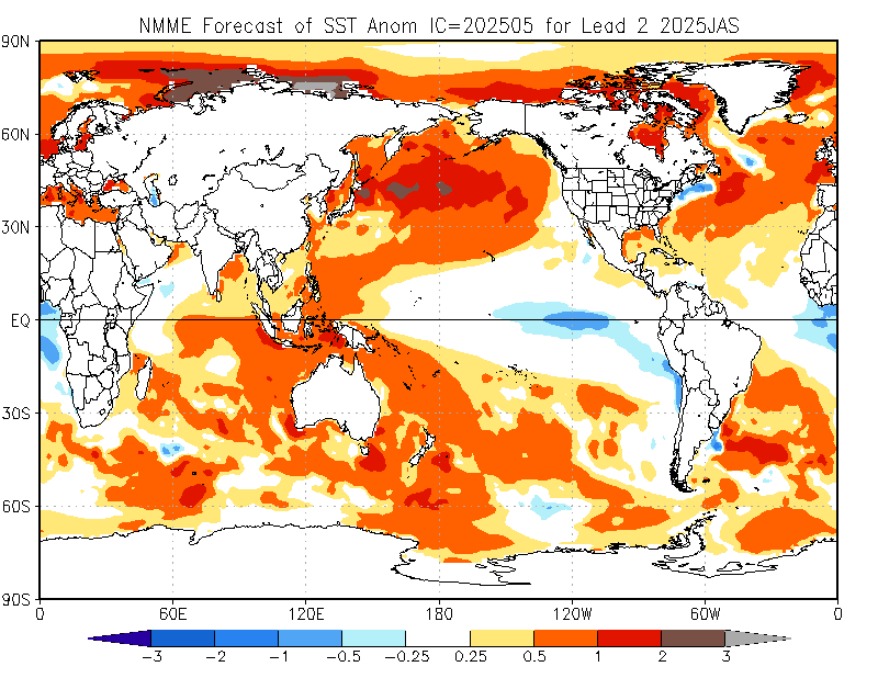
https://cdn.discordapp.com/attachments/716221079323934742/853294243779313705/NMME_fcst.png

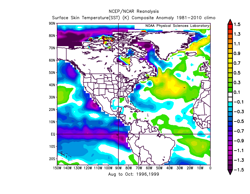
Thank you. I have done so. Based on the data at hand, the MDR is projected to be somewhat cooler than the mean of ASO 1996 and 1999. ENSO is likely to be closer to 1996’s state, which was cool neutral, than to 1999’s, which was strongly -ENSO. Cool neutral ENSO, coupled with a somewhat -AMM/Atlantic Niño, probably implies seasonal ACE considerably lower than either 1996’s or 1999’s. Lower ACE matters because most ACE is generated from long-tracking MH in the MDR, and most of the Category-4+ tropical cyclones to have impacted the CONUS since 1900 originated in the MDR. So a suppressed MDR clearly tends to reduce the overall risk of high-end major impacts to the CONUS. Certainly, exceptions such as 1935, Camille (1969), and Michael (2018) have occurred, but most CONUS-based landfalls of Category 4 or higher have been associated with storms forming in the MDR. Also, a -AMM might reduce the risk of intense “homegrown” storms forming in the Caribbean, particularly late in the season.

On another note, this was a recent CFSv2 forecast for SSTA in the Atlantic issued in mid May and valid as of 26 June 2021:

Image

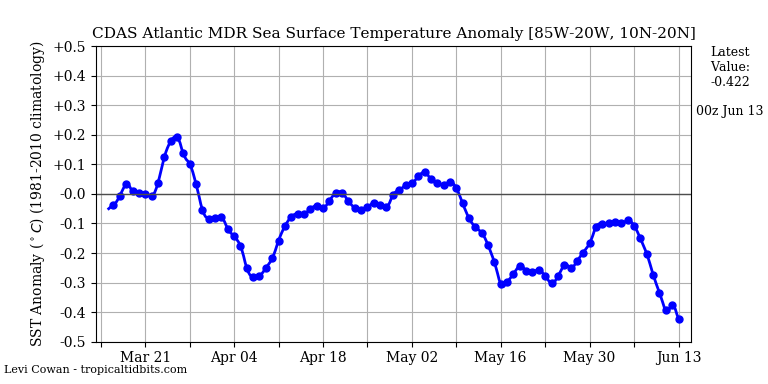
Based on current trends, it is clear that SSTA are going to be well below this projection come the last week of June.
Last edited by Shell Mound on Sat Jun 12, 2021 11:19 am, edited 1 time in total.
0 likes   
CVW / MiamiensisWx / Shell Mound
The posts in this forum are NOT official forecasts and should not be used as such. They are just the opinion of the poster and may or may not be backed by sound meteorological data. They are NOT endorsed by any professional institution or STORM2K. For official information, please refer to products from the NHC and NWS.

User avatar
Yellow Evan
Professional-Met
Professional-Met
Posts: 16143
Age: 27
Joined: Fri Jul 15, 2011 12:48 pm
Location: Henderson, Nevada/Honolulu, HI
Contact:

Re: 2021 Indicators: SST's / SAL / MSLP / Shear / Steering / Instability / Sat Images

#722 Postby Yellow Evan » Sat Jun 12, 2021 11:15 am

HurricaneEnzo wrote:Crazy how every year everybody seems to hyper-focus on MDR temps. It's a little cool but I don't think it will have any bearing on how many storms the MDR produces. Will we have an Isabel or Irma out there in the MDR? Probably not, but anything close to average temps is still warm enough for development. Just look at last year, warm anomalies and while there was MDR development most of the storms struggled to do much while in the MDR. It wasn't until they got further West or North that they did anything. There are far too many variables. And as we have seen if conditions improve the MDR is quick to warm up. It was below average weeks ago but then drastically warmed up to near average in a span of only 2 weeks. It has since went back down but I don't think it is likely to stay like that. There is a beautiful wave out there off of Africa right now. Has no chance of forming because of other things such as shear and SAL but in peak season it would likely be a problem despite cooler temps.


Issue isn’t simply thermodynamics. Cooler SST’s in the MDR means more sinking motion in the region and to offset this, you need a hyper favorable Caribbean which this season doesn’t quite have.
Last edited by Yellow Evan on Sat Jun 12, 2021 11:55 am, edited 1 time in total.
8 likes   

User avatar
Category5Kaiju
Category 5
Category 5
Posts: 4095
Joined: Thu Dec 24, 2020 12:45 pm
Location: Seattle

Re: 2021 Indicators: SST's / SAL / MSLP / Shear / Steering / Instability / Sat Images

#723 Postby Category5Kaiju » Sat Jun 12, 2021 11:47 am

So I think what is important to know is in terms of MDR sst anomalies, it is still June 12, and the MDR does not usually allow for major, powerful storms like Irma, Ivan, Igor, and Luis to occur until mid-August or so, with September being the ideal month for MDR monsters. I understand that there is talk of a cooler than average MDR and how that may make this season slower than anticipated, but again, it's June 12, not August 12. We still have several months to go before we enter the heart of hurricane season, and as we have seen in recent years, the MDR is quick to warm up, with a strong WAM being a beneficial factor in doing this. So what I am personally more curious about is this thought process that I will put forth: "how confident are we that the MDR will remain cooler than normal throughout the next two months and into the hurricane season's heart? What are the chances of this being the case, and what are some factors and variables that we can consider that would favor such an unprecedented, at least in more recent times, occurrence, as well as what are some factors and variables that would undermine this from being the case."
5 likes   
Unless explicitly stated, all info in my posts is based on my own opinions and observations. Tropical storms and hurricanes can be extremely dangerous. Do not think you can beat Mother Nature. Refer to an accredited weather research agency or meteorologist if you need to make serious decisions regarding an approaching storm.

User avatar
captainbarbossa19
Professional-Met
Professional-Met
Posts: 1092
Age: 27
Joined: Wed Aug 21, 2019 11:09 pm
Location: Beaumont, TX

Re: 2021 Indicators: SST's / SAL / MSLP / Shear / Steering / Instability / Sat Images

#724 Postby captainbarbossa19 » Sat Jun 12, 2021 11:55 am

Yellow Evan wrote:
HurricaneEnzo wrote:Crazy how every year everybody seems to hyper-focus on MDR temps. It's a little cool but I don't think it will have any bearing on how many storms the MDR produces. Will we have an Isabel or Irma out there in the MDR? Probably not, but anything close to average temps is still warm enough for development. Just look at last year, warm anomalies and while there was MDR development most of the storms struggled to do much while in the MDR. It wasn't until they got further West or North that they did anything. There are far too many variables. And as we have seen if conditions improve the MDR is quick to warm up. It was below average weeks ago but then drastically warmed up to near average in a span of only 2 weeks. It has since went back down but I don't think it is likely to stay like that. There is a beautiful wave out there off of Africa right now. Has no chance of forming because of other things such as shear and SAL but in peak season it would likely be a problem despite cooler temps.


Issues isn’t simply thermodynamics. Cooler SST’s in the MDR means more sinking motion in the region and to offset this, you need a hyper favorable Caribbean which this season doesn’t quite have.


That is only now. The Caribbean could easily look completely different in August. I suspect it will not be long before we have another major hurricane in this region. Conditions have been good in the past for this region and they will be again at some point.
0 likes   

User avatar
Yellow Evan
Professional-Met
Professional-Met
Posts: 16143
Age: 27
Joined: Fri Jul 15, 2011 12:48 pm
Location: Henderson, Nevada/Honolulu, HI
Contact:

Re: 2021 Indicators: SST's / SAL / MSLP / Shear / Steering / Instability / Sat Images

#725 Postby Yellow Evan » Sat Jun 12, 2021 1:32 pm

captainbarbossa19 wrote:
Yellow Evan wrote:
HurricaneEnzo wrote:Crazy how every year everybody seems to hyper-focus on MDR temps. It's a little cool but I don't think it will have any bearing on how many storms the MDR produces. Will we have an Isabel or Irma out there in the MDR? Probably not, but anything close to average temps is still warm enough for development. Just look at last year, warm anomalies and while there was MDR development most of the storms struggled to do much while in the MDR. It wasn't until they got further West or North that they did anything. There are far too many variables. And as we have seen if conditions improve the MDR is quick to warm up. It was below average weeks ago but then drastically warmed up to near average in a span of only 2 weeks. It has since went back down but I don't think it is likely to stay like that. There is a beautiful wave out there off of Africa right now. Has no chance of forming because of other things such as shear and SAL but in peak season it would likely be a problem despite cooler temps.


Issue isn’t simply thermodynamics. Cooler SST’s in the MDR means more sinking motion in the region and to offset this, you need a hyper favorable Caribbean which this season doesn’t quite have.


That is only now. The Caribbean could easily look completely different in August. I suspect it will not be long before we have another major hurricane in this region. Conditions have been good in the past for this region and they will be again at some point.


Why would it though? Conditions being not the most favorable now relative to normal doesn't inspire the most confidence though I suppose a quiet EPAC/Nino 1+2 possibly cooling down can help in that department. I mean I think the most likely outcome is the ASW saves the season at least somewhat much like 2018 and to a lesser extent 2015, at least in the subtropics but that doesn't mean the latest trends don't point to slightly reduced activity compared to expectations a few months back.
2 likes   

canes92
Tropical Storm
Tropical Storm
Posts: 127
Age: 32
Joined: Tue Mar 06, 2018 1:51 pm

Re: 2021 Indicators: SST's / SAL / MSLP / Shear / Steering / Instability / Sat Images

#726 Postby canes92 » Sat Jun 12, 2021 1:58 pm

Why has vertical instability in the tropical Atlantic been below average for the 15 year in a row?
0 likes   

User avatar
chaser1
S2K Supporter
S2K Supporter
Posts: 5464
Age: 64
Joined: Sat Oct 15, 2005 5:59 pm
Location: Longwood, Fl

Re: 2021 Indicators: SST's / SAL / MSLP / Shear / Steering / Instability / Sat Images

#727 Postby chaser1 » Sat Jun 12, 2021 2:43 pm

In the "for what it's worth" category", I was just looking at the 12Z GFS 500mb height anomaly forecast for the N. Hemisphere. Obviously, we'll see what verifies however the projected long range shows an interesting pattern with practically off the chart upper heights over Greenland (and migrating westward over E. Canada) beginning around June 24. That's still a ways out but the forecast pattern seems to suggest a very negative AMO pattern with broad-scale lower mid level height dropping south over the mid-latitudes of E. CONUS. I'm just curious whether this may be suggestive of an established overall Greenland block pattern for the next few months? Meanwhile, it sure seems like mid level heights across the Atlantic remain largely anchored in place with overall higher anomalies generally forecast from June 18 onward (this in spite of lower 500mb anomalies over much of E. CONUS over time). Right now I'm not seeing any kind of TUTT feature establishing itself under the seemingly stout Atlantic ridging that looks to be perhaps southward displaced but oriented very zonally (rather then any large "trough-ridge-trough-ridge" or cellular configuration).

Even after the Spring barrier, trying to anticipate what the broad scale steering for this season has seemed more convoluted (for me) toward projecting likely storm tracks (in terms of low vs mid latitudes, location of meridional troughs, primary origin of genesis). Time will tell but the recurring theme of mid-level ridging over and east of Florida and the Bahamas, along with indication of broader Atlantic ridging anomalies is increasingly "inching" myself toward a sense that there may be less storm track recurves west of 60W and a heightened concern for a more westward track along or north of the greater Antilles. Of course, whether or not any of this plays out.... are how conducive will conditions prove to be for genesis and where will they occur. That's an entirely different convo.
1 likes   
Andy D

(For official information, please refer to the NHC and NWS products.)

User avatar
chaser1
S2K Supporter
S2K Supporter
Posts: 5464
Age: 64
Joined: Sat Oct 15, 2005 5:59 pm
Location: Longwood, Fl

Re: 2021 Indicators: SST's / SAL / MSLP / Shear / Steering / Instability / Sat Images

#728 Postby chaser1 » Sat Jun 12, 2021 2:46 pm

canes92 wrote:Why has vertical instability in the tropical Atlantic been below average for the 15 year in a row?


2020 (Hurricane Season) just called and laughingly asked the very same question :cheesy:
8 likes   
Andy D

(For official information, please refer to the NHC and NWS products.)

NXStumpy_Robothing
Category 1
Category 1
Posts: 335
Age: 25
Joined: Fri Jun 05, 2020 11:50 pm
Location: North Georgia

Re: 2021 Indicators: SST's / SAL / MSLP / Shear / Steering / Instability / Sat Images

#729 Postby NXStumpy_Robothing » Sat Jun 12, 2021 3:11 pm

chaser1 wrote:
canes92 wrote:Why has vertical instability in the tropical Atlantic been below average for the 15 year in a row?


2020 (Hurricane Season) just called and laughingly asked the very same question :cheesy:

As have 2008, 2010, and 2017 :P

Regardless, iirc I think that vertical instability graph has the wrong baseline or something, since it's always below average, even in hyperactive seasons. I don't typically look at it for that reason. If nothing else, the consistently overachieving ASW/AEJ should indicate that the graph isn't worth paying attention to, and with similar signals of such a feature occurring this season as well, vertical instability will likely not be an inhibiting factor overall.
5 likes   
Undergraduate Meteorology Student, Georgia Institute of Technology

User avatar
captainbarbossa19
Professional-Met
Professional-Met
Posts: 1092
Age: 27
Joined: Wed Aug 21, 2019 11:09 pm
Location: Beaumont, TX

Re: 2021 Indicators: SST's / SAL / MSLP / Shear / Steering / Instability / Sat Images

#730 Postby captainbarbossa19 » Sat Jun 12, 2021 4:50 pm

Yellow Evan wrote:
captainbarbossa19 wrote:
Yellow Evan wrote:
Issue isn’t simply thermodynamics. Cooler SST’s in the MDR means more sinking motion in the region and to offset this, you need a hyper favorable Caribbean which this season doesn’t quite have.


That is only now. The Caribbean could easily look completely different in August. I suspect it will not be long before we have another major hurricane in this region. Conditions have been good in the past for this region and they will be again at some point.


Why would it though? Conditions being not the most favorable now relative to normal doesn't inspire the most confidence though I suppose a quiet EPAC/Nino 1+2 possibly cooling down can help in that department. I mean I think the most likely outcome is the ASW saves the season at least somewhat much like 2018 and to a lesser extent 2015, at least in the subtropics but that doesn't mean the latest trends don't point to slightly reduced activity compared to expectations a few months back.


All I know is that early season trends have not been the most reliable when comparing to peak season activity. The main ingredients needed for strong Caribbean storms at peak season are low wind shear, sufficiently warm SSTs, and a relatively moist environment. There are other things that are important too, but these are the main mechanisms. All of these things are difficult to project at peak season and while there are years that are similar to this one, the outcome for the season may not be the same. Every year is different and while some things may not look so favorable now, they can change quite quickly between now and August. There is also a chance that the currently favorable conditions will become unfavorable at peak season. We do not know so all we can do is observe and try to make sense of things as they happen. All other things are hypotheses.
1 likes   

User avatar
captainbarbossa19
Professional-Met
Professional-Met
Posts: 1092
Age: 27
Joined: Wed Aug 21, 2019 11:09 pm
Location: Beaumont, TX

Re: 2021 Indicators: SST's / SAL / MSLP / Shear / Steering / Instability / Sat Images

#731 Postby captainbarbossa19 » Sat Jun 12, 2021 5:03 pm

By the way, a lot of people probably remember this from last year. I thought I would share Barbossa's timeline because it resonates so well within our great community.

Here we go:

1. June 1st: Everyone is excited about the upcoming season. Many are anticipating upcoming action later in the month, but most know that the real action will most likely start in August.

2. July 1st: One or two TCs manage to form in June. Many complain about how weak and disorganized the cyclones are.

3. July 15th: Lots of SAL is present in the Atlantic basin. However, most people are not surprised by this, as they were expecting it.

4. August 1st: Atlantic is still slow. Dry, stable air is present in the tropics. However, models are beginning to suggest things will be changing within a few weeks.

5. August 15th: Models show nothing in the near-future. Many are becoming skeptical about the season amounting to anything significant.

6. August 23rd: There are multiple invests in the Atlantic and conditions are rapidly beginning to change. The models begin to show cyclogenesis. Many quickly change their minds about a quieter season.

7. August 24th: Some experts continue to doubt signs of the Atlantic awakening. These experts issue outlooks that support original ideas of a quieter season.

8. August 31st: There is now at least one active TC. There is a potential that at least one TC could become a hurricane. Many people appear shocked by the increased activity.

9. September 30th: Several TCs have already formed and dissipated. A few who suggested that the season would be quiet now state that they always knew the Atlantic would spring to life.

10. November 30th: The last storm probably has dissipated by this point. Many look back at the season and state that they are surprised with the outcome.
11 likes   

User avatar
Category5Kaiju
Category 5
Category 5
Posts: 4095
Joined: Thu Dec 24, 2020 12:45 pm
Location: Seattle

Re: 2021 Indicators: SST's / SAL / MSLP / Shear / Steering / Instability / Sat Images

#732 Postby Category5Kaiju » Sat Jun 12, 2021 6:07 pm

captainbarbossa19 wrote:By the way, a lot of people probably remember this from last year. I thought I would share Barbossa's timeline because it resonates so well within our great community.

Here we go:

1. June 1st: Everyone is excited about the upcoming season. Many are anticipating upcoming action later in the month, but most know that the real action will most likely start in August.

2. July 1st: One or two TCs manage to form in June. Many complain about how weak and disorganized the cyclones are.

3. July 15th: Lots of SAL is present in the Atlantic basin. However, most people are not surprised by this, as they were expecting it.

4. August 1st: Atlantic is still slow. Dry, stable air is present in the tropics. However, models are beginning to suggest things will be changing within a few weeks.

5. August 15th: Models show nothing in the near-future. Many are becoming skeptical about the season amounting to anything significant.

6. August 23rd: There are multiple invests in the Atlantic and conditions are rapidly beginning to change. The models begin to show cyclogenesis. Many quickly change their minds about a quieter season.

7. August 24th: Some experts continue to doubt signs of the Atlantic awakening. These experts issue outlooks that support original ideas of a quieter season.

8. August 31st: There is now at least one active TC. There is a potential that at least one TC could become a hurricane. Many people appear shocked by the increased activity.

9. September 30th: Several TCs have already formed and dissipated. A few who suggested that the season would be quiet now state that they always knew the Atlantic would spring to life.

10. November 30th: The last storm probably has dissipated by this point. Many look back at the season and state that they are surprised with the outcome.


Tracking hurricanes is almost like a roller coaster; many ups and downs (with the downs often due to a false sense of a season being inactive and unfavorable).
10 likes   
Unless explicitly stated, all info in my posts is based on my own opinions and observations. Tropical storms and hurricanes can be extremely dangerous. Do not think you can beat Mother Nature. Refer to an accredited weather research agency or meteorologist if you need to make serious decisions regarding an approaching storm.

NXStumpy_Robothing
Category 1
Category 1
Posts: 335
Age: 25
Joined: Fri Jun 05, 2020 11:50 pm
Location: North Georgia

Re: 2021 Indicators: SST's / SAL / MSLP / Shear / Steering / Instability / Sat Images

#733 Postby NXStumpy_Robothing » Sun Jun 13, 2021 1:33 am

Got some pretty active waves for June - some ensemble members (for both the GEFS and the EPS) even had this wave become a short-lived TC over the eastern MDR, though that solution obviously did not occur. Still, perhaps a sign of things to come, and something to keep an eye on, as we slowly approach the heart of the season. Certainly hints at a relatively favorable background state, though using the convective appearance of tropical waves in June to guess at MDR development in August or September is a bit of a fool's errand.

 https://twitter.com/cyclonicwx/status/1403927092530647042


2 likes   
Undergraduate Meteorology Student, Georgia Institute of Technology

Shell Mound
Category 5
Category 5
Posts: 2434
Age: 32
Joined: Thu Sep 07, 2017 3:39 pm
Location: St. Petersburg, FL → Scandinavia

Re: 2021 Indicators: SST's / SAL / MSLP / Shear / Steering / Instability / Sat Images

#734 Postby Shell Mound » Sun Jun 13, 2021 5:27 am

Image
Image
Image

The CFSv2 in mid May was forecasting well-above-average SSTA in the MDR come 26 June. Current trends suggest the MDR will be solidly below average by then.
0 likes   
CVW / MiamiensisWx / Shell Mound
The posts in this forum are NOT official forecasts and should not be used as such. They are just the opinion of the poster and may or may not be backed by sound meteorological data. They are NOT endorsed by any professional institution or STORM2K. For official information, please refer to products from the NHC and NWS.

User avatar
JetFuel_SE
Category 1
Category 1
Posts: 282
Age: 25
Joined: Thu Apr 30, 2020 3:57 pm

Re: 2021 Indicators: SST's / SAL / MSLP / Shear / Steering / Instability / Sat Images

#735 Postby JetFuel_SE » Sun Jun 13, 2021 7:00 am

Shell Mound wrote:https://i.imgur.com/X4V4jzk.png
https://i.postimg.cc/3Nkk41qT/MDRTrend-1.png
https://i.postimg.cc/1XFN7MrK/EC850-Uanom-1.png

The CFSv2 in mid May was forecasting well-above-average SSTA in the MDR come 26 June. Current trends suggest the MDR will be solidly below average by then.

CDAS cold bias btw.
2 likes   

User avatar
Ubuntwo
Category 5
Category 5
Posts: 1406
Age: 31
Joined: Thu Oct 05, 2017 10:41 pm

Re: 2021 Indicators: SST's / SAL / MSLP / Shear / Steering / Instability / Sat Images

#736 Postby Ubuntwo » Sun Jun 13, 2021 10:09 am

JetFuel_SE wrote:
Shell Mound wrote:https://i.imgur.com/X4V4jzk.png
https://i.postimg.cc/3Nkk41qT/MDRTrend-1.png
https://i.postimg.cc/1XFN7MrK/EC850-Uanom-1.png

The CFSv2 in mid May was forecasting well-above-average SSTA in the MDR come 26 June. Current trends suggest the MDR will be solidly below average by then.

CDAS cold bias btw.

This.
CRW (1985-2012 baseline):
Image
4 likes   
Kendall -> SLO -> PBC

Memorable Storms: Katrina (for its Florida landfall...) Wilma Matthew Irma

User avatar
NotSparta
Professional-Met
Professional-Met
Posts: 1668
Age: 23
Joined: Fri Aug 18, 2017 8:24 am
Location: Naples, FL
Contact:

Re: 2021 Indicators: SST's / SAL / MSLP / Shear / Steering / Instability / Sat Images

#737 Postby NotSparta » Sun Jun 13, 2021 1:30 pm

Ubuntwo wrote:
JetFuel_SE wrote:
Shell Mound wrote:https://i.imgur.com/X4V4jzk.png
https://i.postimg.cc/3Nkk41qT/MDRTrend-1.png
https://i.postimg.cc/1XFN7MrK/EC850-Uanom-1.png

The CFSv2 in mid May was forecasting well-above-average SSTA in the MDR come 26 June. Current trends suggest the MDR will be solidly below average by then.

CDAS cold bias btw.

This.
CRW (1985-2012 baseline):
https://media.discordapp.net/attachments/289981599448039425/853651781506695168/ct5km_ssta_v3.png?width=1107&height=676


Turns out CRW doesn't really have that climo and instead tries to emulate the 1985-93 climatology which makes the MDR appear far warmer than it really is. Here's the CRW data but with a 1982-2010 baseline:

Image

Not as cold as CDAS, but it isn't nearly as warm as that map makes you think
8 likes   
This post was probably an opinion of mine, and in no way is official. Please refer to http://www.hurricanes.gov for official tropical analysis and advisories.

My website, with lots of tropical wx graphics, including satellite and recon: http://cyclonicwx.com

User avatar
toad strangler
S2K Supporter
S2K Supporter
Posts: 4543
Joined: Sun Jul 28, 2013 3:09 pm
Location: Earth
Contact:

Re: 2021 Indicators: SST's / SAL / MSLP / Shear / Steering / Instability / Sat Images

#738 Postby toad strangler » Sun Jun 13, 2021 4:04 pm

NotSparta wrote:
Ubuntwo wrote:
JetFuel_SE wrote:CDAS cold bias btw.

This.
CRW (1985-2012 baseline)
https://media.discordapp.net/attachments/289981599448039425/853651781506695168/ct5km_ssta_v3.png?width=1107&height=676


Turns out CRW doesn't really have that climo and instead tries to emulate the 1985-93 climatology which makes the MDR appear far warmer than it really is. Here's the CRW data but with a 1982-2010 baseline:

https://uploads.disquscdn.com/images/c40b770d4db7983fc7a800907d8ab9b59b315164330177d9e0b0ede25e8b8bb9.png

Not as cold as CDAS, but it isn't nearly as warm as that map makes you think


Still looks negligible either way on the cool side / warm side depending on your MDR zip code.
0 likes   

User avatar
Stormybajan
Category 1
Category 1
Posts: 448
Joined: Thu May 20, 2021 3:21 pm
Location: Windward Islands

Re: 2021 Indicators: SST's / SAL / MSLP / Shear / Steering / Instability / Sat Images

#739 Postby Stormybajan » Sun Jun 13, 2021 4:18 pm

NXStumpy_Robothing wrote:Got some pretty active waves for June - some ensemble members (for both the GEFS and the EPS) even had this wave become a short-lived TC over the eastern MDR, though that solution obviously did not occur. Still, perhaps a sign of things to come, and something to keep an eye on, as we slowly approach the heart of the season. Certainly hints at a relatively favorable background state, though using the convective appearance of tropical waves in June to guess at MDR development in August or September is a bit of a fool's errand.

https://twitter.com/cyclonicwx/status/1403927092530647042


Not sure if its just me, but the waves train right now is looking very robust for June, not sure if its that true but its looks more convectively active atleast than usual
1 likes   
Sad West Indies and Manchester United fan ⚽️

User avatar
Ubuntwo
Category 5
Category 5
Posts: 1406
Age: 31
Joined: Thu Oct 05, 2017 10:41 pm

Re: 2021 Indicators: SST's / SAL / MSLP / Shear / Steering / Instability / Sat Images

#740 Postby Ubuntwo » Sun Jun 13, 2021 6:36 pm

NotSparta wrote:
Ubuntwo wrote:
JetFuel_SE wrote:CDAS cold bias btw.

This.
CRW (1985-2012 baseline):
https://media.discordapp.net/attachments/289981599448039425/853651781506695168/ct5km_ssta_v3.png?width=1107&height=676


Turns out CRW doesn't really have that climo and instead tries to emulate the 1985-93 climatology which makes the MDR appear far warmer than it really is. Here's the CRW data but with a 1982-2010 baseline:

https://uploads.disquscdn.com/images/c40b770d4db7983fc7a800907d8ab9b59b315164330177d9e0b0ede25e8b8bb9.png

Not as cold as CDAS, but it isn't nearly as warm as that map makes you think

Interesting. That's also in line with OISST which uses 1990-2019.
Image
0 likes   
Kendall -> SLO -> PBC

Memorable Storms: Katrina (for its Florida landfall...) Wilma Matthew Irma


Return to “Talkin' Tropics”

Who is online

Users browsing this forum: Google Adsense [Bot], NotSparta and 47 guests