Tropical Wave in Bay of Campeche (Is Invest 91L)
Moderator: S2k Moderators
Forum rules

The posts in this forum are NOT official forecasts and should not be used as such. They are just the opinion of the poster and may or may not be backed by sound meteorological data. They are NOT endorsed by any professional institution or STORM2K. For official information, please refer to products from the National Hurricane Center and National Weather Service.
-
zal0phus

- Tropical Storm

- Posts: 201
- Age: 25
- Joined: Mon Jan 07, 2019 8:32 am
- Location: St. Louis
- Contact:
Re: Tropical Wave east of Lesser Antilles (10/40)
One bad model run probably doesn't equate to it not developing. Remember how the models have been seesawing with this system. I know this season has been a letdown but patience is warranted for at least a while longer.
1 likes
Do not take anything I say seriously as a form of meteorological prediction. I am not a meteorologist; I don't think being in law school translates to any special knowledge. I am just a somewhat bullish amateur watcher.
-
BIFF_THE_UNRULY
- Tropical Storm
- Posts: 143
- Joined: Fri Jun 28, 2024 2:12 pm
Re: Tropical Wave east of Lesser Antilles (10/40)
Its over
We're so back
Its Really over
The tropics really are like this in summer
0 likes
Re: Tropical Wave east of Lesser Antilles (10/40)
cajungal wrote:DunedinDave wrote:cajungal wrote:I thought for sure we would have got Francine with this one. Still can’t believe we have not had a named storm since Ernesto. And that already feels like a century ago. Since this season looks to definitely be a bust. I wonder if 2025 will make up for it.
And just 1 since Debby which was 40 days ago. It is amazing given what was forecasted.
They definitely missed it. But 2025 may be the year now instead of this one.
or, this may be the start of a multi year quiet period, who knows.........
1 likes
-
cajungal

- Category 5

- Posts: 2354
- Age: 49
- Joined: Sun Mar 14, 2004 9:34 pm
- Location: Schriever, Louisiana (60 miles southwest of New Orleans)
Re: Tropical Wave east of Lesser Antilles (10/40)
mantis83 wrote:cajungal wrote:DunedinDave wrote:
And just 1 since Debby which was 40 days ago. It is amazing given what was forecasted.
They definitely missed it. But 2025 may be the year now instead of this one.
or, this may be the start of a multi year quiet period, who knows.........
Possible. They can’t always be busy. Boring for storm trackers. But good for property owners
2 likes
-
Kingarabian

- S2K Supporter

- Posts: 16345
- Joined: Sat Aug 08, 2009 3:06 am
- Location: Honolulu, Hawaii
Re: Tropical Wave east of Lesser Antilles (10/40)
18z GFS showing development might be a WGOM system or CA crasher this run.
Last edited by Kingarabian on Sun Sep 01, 2024 11:16 am, edited 1 time in total.
0 likes
RIP Kobe Bryant
-
ouragans

- Category 2

- Posts: 501
- Age: 54
- Joined: Sun Jun 12, 2011 12:09 pm
- Location: Abymes, Guadeloupe F.W.I
- Contact:
Re: Tropical Wave east of Lesser Antilles (10/40)
Boring, that's it!
Can anyone explain me what happened for that wave not to develop? It's not shear, it's not SAL, it's not SST...

Can anyone explain me what happened for that wave not to develop? It's not shear, it's not SAL, it's not SST...
1 likes
Personal forecast disclaimer
This post is a personal point of view, not an information. Please refer to official statements for life-threatening decisions.
David '79, Frederic '79, Hugo '89, Iris, Luis & Marilyn '95, Georges '98, Lenny '99, Dean '07, Irma '17, Maria '17, Fiona '22, Philippe '23, Tammy '23
16°13'33.3,"6N -61°36'39.5"W

Re: Tropical Wave east of Lesser Antilles (10/40)
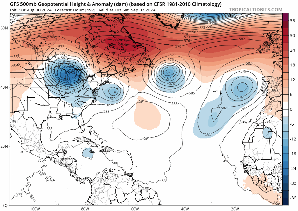
GFS closes it off once again near Belize. Maybe a Bay of Campeche hurricane on this run?
0 likes
Igor 2010, Sandy 2012, Fay 2014, Gonzalo 2014, Joaquin 2015, Nicole 2016, Humberto 2019, Imelda 2025
I am only a tropical weather enthusiast. My predictions are not official and may or may not be backed by sound meteorological data. For official information, please refer to the NHC and NWS products.
I am only a tropical weather enthusiast. My predictions are not official and may or may not be backed by sound meteorological data. For official information, please refer to the NHC and NWS products.
-
ConvergenceZone
.gif)
- Category 5
- Posts: 5241
- Joined: Fri Jul 29, 2005 1:40 am
- Location: Northern California
Re: Tropical Wave east of Lesser Antilles (10/40)
Wow, I didn't expect the models to pretty much turn so bearish on this overnight, although don't want to call this wave dead, as I think it can still develop down the road, even if it's just going into Mexico. The NHC is probably shaking their heads saying, "how did we blow this so badly?" And no this isn't a season cancel post, even if this wave doesn't develop, and we don't get any storms the next 10 days, I still think we can still expect 3 to 4 more storms the 2nd half of September. As far as October and early November goes? it's hard to say, as it depends on the atlantic/carib/gulf conditions.
We will see if GFS and EURO start seeing some more storms develop soon by the middle of the month. Love seeing all of the model posts, so keep it up guys.
We will see if GFS and EURO start seeing some more storms develop soon by the middle of the month. Love seeing all of the model posts, so keep it up guys.
Last edited by ConvergenceZone on Sun Sep 01, 2024 11:30 am, edited 2 times in total.
2 likes
-
Stratton23
- Category 5
- Posts: 3517
- Joined: Fri Jul 21, 2023 10:59 pm
- Location: Katy, Tx
Re: Tropical Wave east of Lesser Antilles (10/40)
The CMC/ 12z GFS runs still develop this, but both get buried into mexico, still worth watching
0 likes
Re: Tropical Wave east of Lesser Antilles (10/40)
I recall with Harvey that models were also aggressive with it as it was entering the Carribean before it decoupled. Then when it got into the western Caribbean the models perked up again and the rest is history. Idalia, if remember correctly, also had a period where models were aggressive with it, dropped it completely for a period of time, then came back to it.
Obviously, Harvey had already formed, and Idalia came from a stronger wave from the Pacific, but if conditions are favorable, I wouldn't be shocked if the models perked up again once it gets into the same areas. Hoping that's not the case, enjoying this period of inactivity!
Obviously, Harvey had already formed, and Idalia came from a stronger wave from the Pacific, but if conditions are favorable, I wouldn't be shocked if the models perked up again once it gets into the same areas. Hoping that's not the case, enjoying this period of inactivity!
3 likes

Re: Tropical Wave east of Lesser Antilles (10/40)
GFS seems to be overdoing the trough on earlier runs, and started correcting with this run. This is probably a key reason why this run doesn't lift the system north (at least not before it gets to the BoC).
I'm not saying GFS's earlier solutions with the trough will absolutely be wrong, but this is common GFS bias and I'd bet on them being wrong more likely than not.
(Also obligatory reminder that models showing something in the BoC crashing into Mexico at this lead time doesn't necessarily mean it will happen: Beryl is one such example.)
0 likes
TC naming lists: retirements and intensity
Most aggressive Advisory #1's in North Atlantic (cr. kevin for starting the list)
Most aggressive Advisory #1's in North Atlantic (cr. kevin for starting the list)
-
TomballEd
- Category 5
- Posts: 1260
- Age: 62
- Joined: Wed Aug 16, 2023 4:52 pm
- Location: Spring/Klein area, not Tomball
Re: Tropical Wave east of Lesser Antilles (10/40)
A couple of model cycles that threatened the US Gulf Coast, but looking at satellite, there is little chance this develops before the Caribbean, and will move fairly quickly W, and if it does develop, it probably doesn't feel the trough and stays at low latitude, and doesn't have that much time to strengthen before Central America or the Yucatan.
Nothing carved in stone, but ground truth, it isn't developing anytime soon, and what models had been showing about late developers, probably not a direct US threat. Can't rule out Northern Mexico, even the TX border. I wouldn't have lowered it from 50% to 40% when NHC did, but 40% seems about right for now. Maybe even a smidge generous.
I mention at a week plus away, this could change? I throw these in because when I post that it probably isn't a US threat anymore, someone will mention the Korean or Albanian model. Probably doesn't mean it won't happen. I doubt Albania has a model, but who knows?
0 likes
-
Stratton23
- Category 5
- Posts: 3517
- Joined: Fri Jul 21, 2023 10:59 pm
- Location: Katy, Tx
Re: Tropical Wave east of Lesser Antilles (10/40)
I think the GFS is overdoing ridging to much and lifts the trough out too fast, im not sold on this just getting buried into mexico just yet, , not saying they wont be correct here, but im still not sold on a track that gets buried in CA, the GFS has a progressive bias so their is a chance its lifting the trough out too fast
1 likes
-
TomballEd
- Category 5
- Posts: 1260
- Age: 62
- Joined: Wed Aug 16, 2023 4:52 pm
- Location: Spring/Klein area, not Tomball
Re: Tropical Wave east of Lesser Antilles (10/40)
Stratton23 wrote:I think the GFS is overdoing ridging to much and lifts the trough out too fast, im not sold on this just getting buried into mexico just yet, , not saying they wont be correct here, but im still not sold on a track that gets buried in CA, the GFS has a progressive bias so their is a chance its lifting the trough out too fast
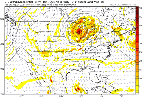
Time to post another GFS CONUS 500 mb trend map. The GFS isn't very stable on the forecast 500 mb pattern. 500 mb pattern doesn't matter much if the system is very weak and very low latitude. 500 mb pattern is everything if this can become a TC by about Jamaica.
2 likes
Re: Tropical Wave east of Lesser Antilles (10/40)
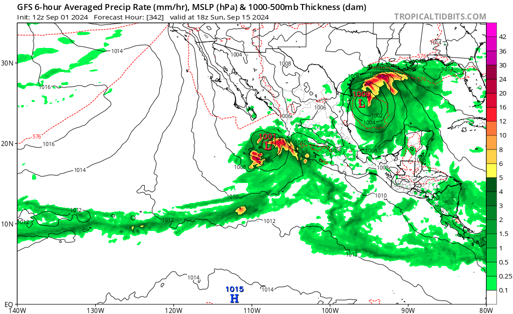
So after GFS has the system landfall in BoC, it then (tries to) develops two simultaneous storms on opposite ends of Mexico 
0 likes
TC naming lists: retirements and intensity
Most aggressive Advisory #1's in North Atlantic (cr. kevin for starting the list)
Most aggressive Advisory #1's in North Atlantic (cr. kevin for starting the list)
-
Stratton23
- Category 5
- Posts: 3517
- Joined: Fri Jul 21, 2023 10:59 pm
- Location: Katy, Tx
Re: Tropical Wave east of Lesser Antilles (10/40)
Wonky GFS run, goes into mexico, then comes back out over water, reforms into a TS and lifts north toward texas
2 likes
-
Ivanhater

- Storm2k Moderator

- Posts: 11221
- Age: 39
- Joined: Fri Jul 01, 2005 8:25 am
- Location: Pensacola
Re: Tropical Wave east of Lesser Antilles (10/40)
Looks like the Gulf Coast got extremely lucky with this one. If it developed in the Caribbean, it would have felt the weakness and bombed out in the Gulf.
0 likes
Michael
-
cajungal
- Category 5
- Posts: 2354
- Age: 49
- Joined: Sun Mar 14, 2004 9:34 pm
- Location: Schriever, Louisiana (60 miles southwest of New Orleans)
Re: Tropical Wave east of Lesser Antilles (10/40)
Ivanhater wrote:Looks like the Gulf Coast got extremely lucky with this one. If it developed in the Caribbean, it would have felt the weakness and bombed out in the Gulf.
Looks better for now. But still can’t completely write it off for gulf coast just yet.
1 likes
-
Stratton23
- Category 5
- Posts: 3517
- Joined: Fri Jul 21, 2023 10:59 pm
- Location: Katy, Tx
Re: Tropical Wave east of Lesser Antilles (10/40)
Ivanhater the gulf coast is still not in the clear yet
0 likes
-
cycloneye
- Admin

- Posts: 149261
- Age: 69
- Joined: Thu Oct 10, 2002 10:54 am
- Location: San Juan, Puerto Rico
Re: Tropical Wave east of Lesser Antilles (10/40)
Cut and paste.
Near the Lesser Antilles and Caribbean Sea:
Shower activity associated with a tropical wave located several
hundred miles east of the Lesser Antilles has changed little in
organization since yesterday. The disturbance is expected to move
westward and reach the Lesser Antilles on Monday, then cross the
eastern Caribbean Sea on Tuesday. Environmental conditions are
forecast to become more conducive for development while the system
moves across the central and western Caribbean Sea during the middle
and latter parts of the week, and a tropical depression could form
during that time. Regardless of development, this system could
result in some gusty winds and locally heavy rainfall over portions
of the Lesser Antilles on Monday.
* Formation chance through 48 hours...low...10 percent.
* Formation chance through 7 days...medium...40 percent.
1 likes
Visit the Caribbean-Central America Weather Thread where you can find at first post web cams,radars
and observations from Caribbean basin members Click Here
and observations from Caribbean basin members Click Here
Who is online
Users browsing this forum: kevin, mixedDanilo.E and 71 guests