2018 Tropics: Global Model Runs Discussion (Out to day 16)

This is the general tropical discussion area. Anyone can take their shot at predicting a storms path.

Moderator: S2k Moderators

Forum rules

The posts in this forum are NOT official forecasts and should not be used as such. They are just the opinion of the poster and may or may not be backed by sound meteorological data. They are NOT endorsed by any professional institution or STORM2K. For official information, please refer to products from the National Hurricane Center and National Weather Service.

Help Support Storm2K
Message
Author
User avatar
SoupBone
Category 5
Category 5
Posts: 3111
Joined: Tue Sep 20, 2005 5:24 pm

Re: 2018 Tropics: Global Model Runs Discussion (Out to day 16)

#761 Postby SoupBone » Fri Jun 08, 2018 2:08 pm

Aric Dunn wrote:
LarryWx wrote:
SoupBone wrote:
But why? Do they distrust the GFS that much that they're discounting it completely? Doesn't seem to exude a whole lot of confidence when it continues to push this system run after run after run. It's....odd.


Part of the reasoning may be that even the GFS now suggests any possible genesis would likely be after 5 days.


current GFS and CMC are 3 to 4 days. they, of course, interpret everything and make a judgment. They also have access to other model outputs we do not. most notably the florida state model which by all indications is superior to the current model suit.


Thanks, Aric. Good info. :flag:
1 likes   
Personal Forecast Disclaimer:
The posts in this forum are NOT official forecast and should not be used as such. They are just the opinion of the poster and may or may not be backed by sound meteorological data. They are NOT endorsed by any professional institution or storm2k.org. For official information, please refer to the NHC and NWS products.

User avatar
GCANE
S2K Supporter
S2K Supporter
Posts: 11498
Joined: Mon Oct 22, 2007 8:03 am

Re: 2018 Tropics: Global Model Runs Discussion (Out to day 16)

#762 Postby GCANE » Fri Jun 08, 2018 2:12 pm

That ULL I mentioned that would develop in about 200 hrs looks like it may kick in a poleward outflow channel if this spins up in the GOM

Image
0 likes   

User avatar
Hammy
Category 5
Category 5
Posts: 5849
Age: 42
Joined: Fri May 25, 2012 5:25 pm
Contact:

Re: 2018 Tropics: Global Model Runs Discussion (Out to day 16)

#763 Postby Hammy » Fri Jun 08, 2018 2:20 pm

Euro appears to show a piece of energy going up over Central America and into the GoM (while not developing) but someone earlier mentioned it has a bad habit of overdoing the 500MB high pressure, so could this be an early hint that it might start trending towards development over the next several runs? If I remember correctly it had Alberto much further west than what played out as well.
2 likes   
The above post is not official and should not be used as such. It is the opinion of the poster and may or may not be backed by sound meteorological data. It is not endorsed by any professional institution or storm2k.org. For official information, please refer to the NHC and NWS products.

User avatar
Kingarabian
S2K Supporter
S2K Supporter
Posts: 15981
Joined: Sat Aug 08, 2009 3:06 am
Location: Honolulu, Hawaii

Re: 2018 Tropics: Global Model Runs Discussion (Out to day 16)

#764 Postby Kingarabian » Fri Jun 08, 2018 2:30 pm

Hammy wrote:Euro appears to show a piece of energy going up over Central America and into the GoM (while not developing) but someone earlier mentioned it has a bad habit of overdoing the 500MB high pressure, so could this be an early hint that it might start trending towards development over the next several runs? If I remember correctly it had Alberto much further west than what played out as well.


EPS is running. Will give us a hint if the Euro is caving in or not.
0 likes   
RIP Kobe Bryant

User avatar
NDG
S2K Supporter
S2K Supporter
Posts: 15446
Joined: Sun Jul 09, 2006 10:14 pm
Location: Orlando, FL

Re: 2018 Tropics: Global Model Runs Discussion (Out to day 16)

#765 Postby NDG » Fri Jun 08, 2018 2:45 pm

Kingarabian wrote:
Hammy wrote:Euro appears to show a piece of energy going up over Central America and into the GoM (while not developing) but someone earlier mentioned it has a bad habit of overdoing the 500MB high pressure, so could this be an early hint that it might start trending towards development over the next several runs? If I remember correctly it had Alberto much further west than what played out as well.


EPS is running. Will give us a hint if the Euro is caving in or not.


??
It already ran :D
0 likes   

User avatar
Kingarabian
S2K Supporter
S2K Supporter
Posts: 15981
Joined: Sat Aug 08, 2009 3:06 am
Location: Honolulu, Hawaii

Re: 2018 Tropics: Global Model Runs Discussion (Out to day 16)

#766 Postby Kingarabian » Fri Jun 08, 2018 2:48 pm

NDG wrote:
Kingarabian wrote:
Hammy wrote:Euro appears to show a piece of energy going up over Central America and into the GoM (while not developing) but someone earlier mentioned it has a bad habit of overdoing the 500MB high pressure, so could this be an early hint that it might start trending towards development over the next several runs? If I remember correctly it had Alberto much further west than what played out as well.


EPS is running. Will give us a hint if the Euro is caving in or not.


??
It already ran :D


The websites I use, weatherbell.com and weathermodels.com take about an hour to complete the EPS run after the OP model run finishes.

edit: EPS through 240 hours, has maybe 3-4 members showing weak western GOM development.
2 likes   
RIP Kobe Bryant

LarryWx
S2K Supporter
S2K Supporter
Posts: 6312
Joined: Sun Sep 07, 2003 2:04 pm
Location: GA

Re: 2018 Tropics: Global Model Runs Discussion (Out to day 16)

#767 Postby LarryWx » Fri Jun 08, 2018 2:52 pm

The EPS supports the quiet Euro with still very few members getting to below 1004 mb in the N GOM. I count only 2 of 51 during 6/16-9 over water under 1004 mb there that then threaten the NW GOM coast. There's something stronger over land that I'm ignoring. There's also a few active members in the far SW BoC as well as 2 coming off Yucatan later fwiw.
2 likes   
Personal Forecast Disclaimer:
The posts in this forum are NOT official forecasts and should not be used as such. They are just the opinion of the poster and may or may not be backed by sound meteorological data. They are NOT endorsed by any professional institution or storm2k.org. For official information, please refer to the NHC and NWS products.

TheStormExpert

Re: 2018 Tropics: Global Model Runs Discussion (Out to day 16)

#768 Postby TheStormExpert » Fri Jun 08, 2018 3:12 pm

12z EPS is the least enthusiastic Euro Ensemble support in days!

Btw, does the 12z UKMET still develop anything?
0 likes   

User avatar
Tampa Bay Hurricane
Category 5
Category 5
Posts: 5597
Age: 37
Joined: Fri Jul 22, 2005 7:54 pm
Location: St. Petersburg, FL

Re: 2018 Tropics: Global Model Runs Discussion (Out to day 16)

#769 Postby Tampa Bay Hurricane » Fri Jun 08, 2018 3:13 pm

Recent model trends from gfs, icon, and cmc indicate that this future storm is likely to track into the central or western gulf. This seems reasonable considering that the euro, despite not developing this system much, shows markedly increased heights bridging into each other from Florida west into TX. Euro shows a trough then coming into the central gulf. The sum of these steering currents would over time steer the potential cyclone into the central gulf. It is still uncertain as to whether anything develops, but at the very least enhanced moisture or rain would spread into the central gulf coast regardless of development.
0 likes   

User avatar
gatorcane
S2K Supporter
S2K Supporter
Posts: 23691
Age: 47
Joined: Sun Mar 13, 2005 3:54 pm
Location: Boca Raton, FL

Re: 2018 Tropics: Global Model Runs Discussion (Out to day 16)

#770 Postby gatorcane » Fri Jun 08, 2018 3:24 pm

TheStormExpert wrote:12z EPS is the least enthusiastic Euro Ensemble support in days!

Btw, does the 12z UKMET still develop anything?


Nope. Going to need the EPAC to slow down before we see something in the Western Caribbean / GOM.
1 likes   

HURRICANELONNY
Category 5
Category 5
Posts: 1383
Joined: Wed May 07, 2003 6:48 am
Location: HOLLYWOOD.FL

Re: 2018 Tropics: Global Model Runs Discussion (Out to day 16)

#771 Postby HURRICANELONNY » Fri Jun 08, 2018 3:43 pm

Always betwwen the GFS and the Euro. Do they ever agree

There is a large divergence in model guidance come the middle of
next week. The European model (ecmwf) maintains the persistent Bermuda high. The
GFS, however, has a low pressure system developing near the
Yucatan, and moving north into the central Gulf. This is still
towards the end of the forecast period and this scenario is very
uncertain, and low confidence in what impact, if any, it will have
on South Florida. So, have kept just general showers and
thunderstorms for now. :roll:
0 likes   
hurricanelonny

User avatar
stormhunter7
Category 2
Category 2
Posts: 762
Joined: Mon May 26, 2008 3:13 pm
Location: Panama City Beach, Florida
Contact:

Re: 2018 Tropics: Global Model Runs Discussion (Out to day 16)

#772 Postby stormhunter7 » Fri Jun 08, 2018 5:32 pm

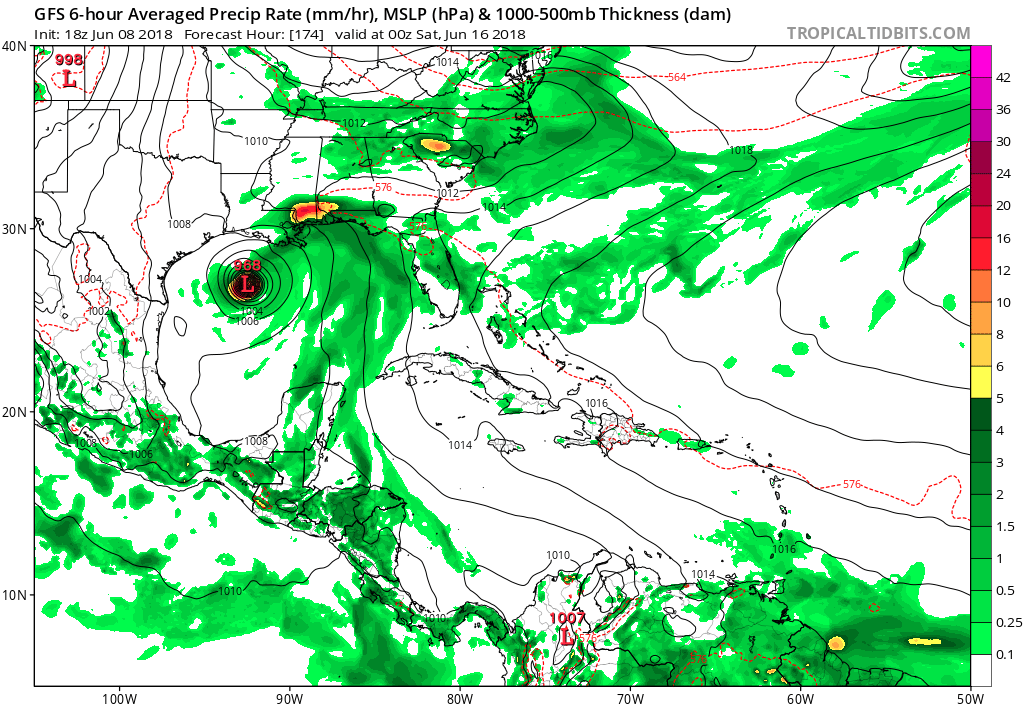
18z gfs rolling and through 174hrs... bad sign for Texas and La! aka, stall and deepening system in NW GOM
0 likes   
The following post is NOT an official forecast and should not be used as such. It is just the opinion of the poster and may or may not be backed by sound meteorological data. It is NOT endorsed by any professional institution including storm2k.org For Official Information please refer to the NHC and NWS products. http://www.nhc.noaa.gov

User avatar
gatorcane
S2K Supporter
S2K Supporter
Posts: 23691
Age: 47
Joined: Sun Mar 13, 2005 3:54 pm
Location: Boca Raton, FL

Re: 2018 Tropics: Global Model Runs Discussion (Out to day 16)

#773 Postby gatorcane » Fri Jun 08, 2018 5:33 pm

The GFS just won’t give up, in fact it looks to be doubling down:

Image
0 likes   

User avatar
Steve
S2K Supporter
S2K Supporter
Posts: 9621
Joined: Sat Apr 05, 2003 11:41 pm
Location: Not a state-caster

Re: 2018 Tropics: Global Model Runs Discussion (Out to day 16)

#774 Postby Steve » Fri Jun 08, 2018 5:37 pm

stormhunter7 wrote:18z gfs rolling and through 174hrs... bad sign for Texas and La! aka, stall and deepening system in NW GOM


It’s still bringing the Yucatan low up faster than the hurricane moving toward the Baja though it’s been closing the gap over time. It sees a stronger reflection on this side which doesn’t seem as likely, but you never know until it happens.
0 likes   

User avatar
gatorcane
S2K Supporter
S2K Supporter
Posts: 23691
Age: 47
Joined: Sun Mar 13, 2005 3:54 pm
Location: Boca Raton, FL

Re: 2018 Tropics: Global Model Runs Discussion (Out to day 16)

#775 Postby gatorcane » Fri Jun 08, 2018 5:40 pm

956 mb:

Image
0 likes   

Aric Dunn
Category 5
Category 5
Posts: 21238
Age: 42
Joined: Sun Sep 19, 2004 9:58 pm
Location: Ready for the Chase.
Contact:

Re: 2018 Tropics: Global Model Runs Discussion (Out to day 16)

#776 Postby Aric Dunn » Fri Jun 08, 2018 5:49 pm

well the 18z GFS os rather interesting..
1 likes   
Note: If I make a post that is brief. Please refer back to previous posts for the analysis or reasoning. I do not re-write/qoute what my initial post said each time.
If there is nothing before... then just ask :)

Space & Atmospheric Physicist, Embry-Riddle Aeronautical University,
I believe the sky is falling...

User avatar
Steve
S2K Supporter
S2K Supporter
Posts: 9621
Joined: Sat Apr 05, 2003 11:41 pm
Location: Not a state-caster

Re: 2018 Tropics: Global Model Runs Discussion (Out to day 16)

#777 Postby Steve » Fri Jun 08, 2018 5:59 pm

Looks like around Chambers County at 204 hours. That’s valid for next Sunday at 1am CDT or 8.5 days from 18z/1pm today. Low 960s looks like a strong 2 there.
Last edited by Steve on Fri Jun 08, 2018 6:00 pm, edited 1 time in total.
0 likes   

User avatar
Hypercane_Kyle
Category 5
Category 5
Posts: 3352
Joined: Sat Mar 07, 2015 7:58 pm
Location: Cape Canaveral, FL

Re: 2018 Tropics: Global Model Runs Discussion (Out to day 16)

#778 Postby Hypercane_Kyle » Fri Jun 08, 2018 5:59 pm

GFS showing genesis as soon as Wednesday morning. If this develops and the ECMWF doesn't even pick it up <5 days in advance that's incredibly disappointing (vice-versa if the GFS/CMC system doesn't develop, either).
1 likes   
My posts are my own personal opinion, defer to the National Hurricane Center (NHC) and other NOAA products for decision making during hurricane season.

User avatar
Steve
S2K Supporter
S2K Supporter
Posts: 9621
Joined: Sat Apr 05, 2003 11:41 pm
Location: Not a state-caster

Re: 2018 Tropics: Global Model Runs Discussion (Out to day 16)

#779 Postby Steve » Fri Jun 08, 2018 6:03 pm

Hypercane_Kyle wrote:The CMC support makes me question whether or not the GFS is truly off its rocker. Additionally, its showing genesis as soon as Wednesday morning. If this develops and the ECMWF doesn't even pick it up <5 days in advance that's incredibly disappointing (vice-versa if the GFS/CMC system doesn't develop, either).


Possibly its solutions are gradually shifting to an elongated tropical surge coming up along the upper Mexican and Texas coasts. I’m neutral on a prediction at this point, so I’m watching.
1 likes   

User avatar
cycloneye
Admin
Admin
Posts: 145398
Age: 68
Joined: Thu Oct 10, 2002 10:54 am
Location: San Juan, Puerto Rico

Re: 2018 Tropics: Global Model Runs Discussion (Out to day 16)

#780 Postby cycloneye » Fri Jun 08, 2018 6:13 pm

NHC doesn't buy the 956 mbs.

Tropical Weather Outlook
NWS National Hurricane Center Miami FL
800 PM EDT Fri Jun 8 2018

For the North Atlantic...Caribbean Sea and the Gulf of Mexico:

Tropical cyclone formation is not expected during the next 5 days.

$$
Forecaster Brennan
2 likes   
Visit the Caribbean-Central America Weather Thread where you can find at first post web cams,radars
and observations from Caribbean basin members Click Here


Return to “Talkin' Tropics”

Who is online

Users browsing this forum: AnnularCane, Google [Bot] and 33 guests