ENSO Updates (2007 thru 2023)
Moderator: S2k Moderators
Forum rules

The posts in this forum are NOT official forecasts and should not be used as such. They are just the opinion of the poster and may or may not be backed by sound meteorological data. They are NOT endorsed by any professional institution or STORM2K. For official information, please refer to products from the National Hurricane Center and National Weather Service.
-
Kingarabian

- S2K Supporter

- Posts: 16361
- Joined: Sat Aug 08, 2009 3:06 am
- Location: Honolulu, Hawaii
Re: ENSO: CPC Monthly update: Neutral at least thru Spring / 50% chance for El Nino by late Summer and Fall
Ntxw, I'm going with a mixture of 2006 and 2009.
0 likes
RIP Kobe Bryant


Re: ENSO: CPC Monthly update: Neutral at least thru Spring / 50% chance for El Nino by late Summer and Fall
Kingarabian wrote:Ntxw, I'm going with a mixture of 2006 and 2009.
It's anyone's guess at the moment. There really is no historical context that really matches what is going on. I would hate to be a seasonal forecaster and/or having to predict tropical season for any basin this coming year. Short term oscillations seems to be dictating currently.
1 likes
The above post and any post by Ntxw is NOT an official forecast and should not be used as such. It is just the opinion of the poster and may or may not be backed by sound meteorological data. It is NOT endorsed by any professional institution including Storm2k. For official information, please refer to NWS products.
Help support Storm2K!
-
Kingarabian
- S2K Supporter
- Posts: 16361
- Joined: Sat Aug 08, 2009 3:06 am
- Location: Honolulu, Hawaii
Re: ENSO: CPC Monthly update: Neutral at least thru Spring / 50% chance for El Nino by late Summer and Fall
Ntxw wrote:Kingarabian wrote:Ntxw, I'm going with a mixture of 2006 and 2009.
It's anyone's guess at the moment. There really is no historical context that really matches what is going on. I would hate to be a seasonal forecaster and/or having to predict tropical season for any basin.
Yeah. If it weren't for that cold pool, 2006 and 2009 would've been nice analogs. But both those seasons had cold PDO's...
Too bad research on the PDO is limited.
Because I think the elephant in the room is the PDO. We know it can play a key role in turning the tide for ENSO. We recently saw a warm PDO hold off La Nina, and in previous years, a cool PDO aborted a couple of El Nino's. I wonder what and how much of a role it will play this year.
0 likes
RIP Kobe Bryant
Re: ENSO: CPC Monthly update: Neutral at least thru Spring / 50% chance for El Nino by late Summer and Fall
Kingarabian wrote:Yeah. If it weren't for that cold pool, 2006 and 2009 would've been nice analogs. But both those seasons had cold PDO's...
Too bad research on the PDO is limited.
Because I think the elephant in the room is the PDO. We know it can play a key role in turning the tide for ENSO. We recently saw a warm PDO hold off La Nina, and in previous years, a cool PDO aborted a couple of El Nino's. I wonder what and how much of a role it will play this year.
The PDO is definitely the elephant in the room. Whether it is cause or effect (chicken or egg?) there's no doubt it plays some factor. We've seen it kill Ninos or promote strong events. There's no doubt that the 3+ years of +PDO is telling us any cold enso forecast likely gets muted and warm enso forecast tends to do better. My guess is that the tropical oceans doesn't want a Nino but the background PDO is inching it forward. Conflicting, perhaps we just oscillate with warm ENSO and may sneak out a Nino.
1 likes
The above post and any post by Ntxw is NOT an official forecast and should not be used as such. It is just the opinion of the poster and may or may not be backed by sound meteorological data. It is NOT endorsed by any professional institution including Storm2k. For official information, please refer to NWS products.
Help support Storm2K!
Help support Storm2K!

-
cycloneye

- Admin

- Posts: 149442
- Age: 69
- Joined: Thu Oct 10, 2002 10:54 am
- Location: San Juan, Puerto Rico
Re: ENSO: CPC Monthly update: Neutral at least thru Spring / 50% chance for El Nino by late Summer and Fall
0 likes
Visit the Caribbean-Central America Weather Thread where you can find at first post web cams,radars
and observations from Caribbean basin members Click Here
and observations from Caribbean basin members Click Here
-
weathaguyry

- Category 5

- Posts: 1273
- Age: 22
- Joined: Wed Jun 15, 2016 5:16 am
- Location: Long Island, NY
Re: ENSO: CPC Monthly update: Neutral at least thru Spring / 50% chance for El Nino by late Summer and Fall
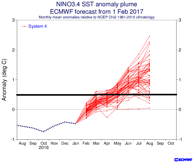
cycloneye wrote:Some doubts about the ECMWF forecast.
https://twitter.com/EricBlake12/status/853259115971448832
I agree with this, it seems that each and every day as we inch closer to the hurricane season, we see more and more things that point to El-Nino not forming, at least not in the near future, I could maybe see something weak forming around the OND timeframe, if that. The only thing that has pointed towards an El-Nino was the past two days where the SOI literally crashed to -34 on both days, but I even have some doubts that it will actually stay that low, because that is a huge leap from neutral, and it doesn't make sense to me that it would flip so quick like that. Not to mention that even if winds start blowing in the other direction, there isn't even a very warm pool of water to move east. Based on what I see with some resemblance of a positive tripole in the Atlantic (which looked negative back in March) I think the atmosphere is still trying to even itself out from the last Super El- Nino in 2016, even though the PDO is positive, I would guess warm-neutral for the peak of the season, maybe Modoki at best. But as I've said before... I am not a professional meteorologist, I am only a 13 year old weather geek
0 likes
My posts are only my opinions and NOT official forecasts. For official forecasts, consult the National Hurricane Center or the National Weather Service.
Irene 11', Sandy 12', Fay 20’, Isaias 20’, Elsa 21’, Henri 21’, Ida 21’
Irene 11', Sandy 12', Fay 20’, Isaias 20’, Elsa 21’, Henri 21’, Ida 21’
-
Hurricaneman

- Category 5
- Posts: 7404
- Age: 45
- Joined: Tue Aug 31, 2004 3:24 pm
- Location: central florida
Re: ENSO: CPC Monthly update: Neutral at least thru Spring / 50% chance for El Nino by late Summer and Fall
weathaguyry wrote:cycloneye wrote:Some doubts about the ECMWF forecast.
https://twitter.com/EricBlake12/status/853259115971448832
I agree with this, it seems that each and every day as we inch closer to the hurricane season, we see more and more things that point to El-Nino not forming, at least not in the near future, I could maybe see something weak forming around the OND timeframe, if that. The only thing that has pointed towards an El-Nino was the past two days where the SOI literally crashed to -34 on both days, but I even have some doubts that it will actually stay that low, because that is a huge leap from neutral, and it doesn't make sense to me that it would flip so quick like that. Not to mention that even if winds start blowing in the other direction, there isn't even a very warm pool of water to move east. Based on what I see with some resemblance of a positive tripole in the Atlantic (which looked negative back in March) I think the atmosphere is still trying to even itself out from the last Super El- Nino in 2016, even though the PDO is positive, I would guess warm-neutral for the peak of the season, maybe Modoki at best. But as I've said before... I am not a professional meteorologist, I am only a 13 year old weather geek
That's actually the first thing you look for an SOI crash as that usually switches the trades to possible westerlies causing the warm WPAC to spread east to the EPAC and surface causing an El Niño
0 likes
Re: ENSO Updates
I really dislike the term modoki as personal preference. I think 2004 really muddled this term poorly and is often a scapegoat for what was a favorable period in the Atlantic. Wouldn't Nino 3.4 not achieving 0.5C criteria yet Nino 3 and NIno 1+2 being hot not qualify as a modoki either? To me strength of an ENSO event is often more useful than what kind it is.
0 likes
The above post and any post by Ntxw is NOT an official forecast and should not be used as such. It is just the opinion of the poster and may or may not be backed by sound meteorological data. It is NOT endorsed by any professional institution including Storm2k. For official information, please refer to NWS products.
Help support Storm2K!
Help support Storm2K!
Re: ENSO Updates
The ECMWF's forecast has been doing an ok job in its shorter range forecast for Nino 3.4
The trend for Aug-Sep period has been for weak el nino instead of a moderate el nino like earlier forecasted in its longer range.
But I wouldn't doubt if we just end up with a warm neutral ENSO over all.
The trend for Aug-Sep period has been for weak el nino instead of a moderate el nino like earlier forecasted in its longer range.
But I wouldn't doubt if we just end up with a warm neutral ENSO over all.
3 likes
-
weathaguyry
- Category 5
- Posts: 1273
- Age: 22
- Joined: Wed Jun 15, 2016 5:16 am
- Location: Long Island, NY
Re: ENSO: CPC Monthly update: Neutral at least thru Spring / 50% chance for El Nino by late Summer and Fall
Hurricaneman wrote:weathaguyry wrote:cycloneye wrote:Some doubts about the ECMWF forecast.
https://twitter.com/EricBlake12/status/853259115971448832
I agree with this, it seems that each and every day as we inch closer to the hurricane season, we see more and more things that point to El-Nino not forming, at least not in the near future, I could maybe see something weak forming around the OND timeframe, if that. The only thing that has pointed towards an El-Nino was the past two days where the SOI literally crashed to -34 on both days, but I even have some doubts that it will actually stay that low, because that is a huge leap from neutral, and it doesn't make sense to me that it would flip so quick like that. Not to mention that even if winds start blowing in the other direction, there isn't even a very warm pool of water to move east. Based on what I see with some resemblance of a positive tripole in the Atlantic (which looked negative back in March) I think the atmosphere is still trying to even itself out from the last Super El- Nino in 2016, even though the PDO is positive, I would guess warm-neutral for the peak of the season, maybe Modoki at best. But as I've said before... I am not a professional meteorologist, I am only a 13 year old weather geek
That's actually the first thing you look for an SOI crash as that usually switches the trades to possible westerlies causing the warm WPAC to spread east to the EPAC and surface causing an El Niño
I agree, I just personally think that El-Nino won't come right away, which is why I think something may not form until OND, and if something forms, it may be heavily west-biased. In 2009 there was a big warm pool in the sub-surface around 180, and in 2006 there was a lot of warm water in the subsurface in general, so to me this year just doesn't line up with a classic Nino setup
0 likes
My posts are only my opinions and NOT official forecasts. For official forecasts, consult the National Hurricane Center or the National Weather Service.
Irene 11', Sandy 12', Fay 20’, Isaias 20’, Elsa 21’, Henri 21’, Ida 21’
Irene 11', Sandy 12', Fay 20’, Isaias 20’, Elsa 21’, Henri 21’, Ida 21’
-
Kingarabian
- S2K Supporter
- Posts: 16361
- Joined: Sat Aug 08, 2009 3:06 am
- Location: Honolulu, Hawaii
Re: ENSO Updates
Looking at the anomalies, the WWB is kicking in as winds begin reversing near the equatorial CPAC, starting to move west to east.

0 likes
RIP Kobe Bryant
-
weathaguyry
- Category 5
- Posts: 1273
- Age: 22
- Joined: Wed Jun 15, 2016 5:16 am
- Location: Long Island, NY
Re: ENSO Updates
The SOI is very negative for the third consecutive day, if El-Nino is going to happen, we should see signs of it soon, and we'll see how easy it will be for it to form due to the current state of the atmosphere still somewhat recovering from the last El-Nino, and the fact that there isn't much warm water in the subsurface.
0 likes
My posts are only my opinions and NOT official forecasts. For official forecasts, consult the National Hurricane Center or the National Weather Service.
Irene 11', Sandy 12', Fay 20’, Isaias 20’, Elsa 21’, Henri 21’, Ida 21’
Irene 11', Sandy 12', Fay 20’, Isaias 20’, Elsa 21’, Henri 21’, Ida 21’
-
euro6208
Re: ENSO Updates
It will be interesting to see if the WPAC can produce a Cat 4 or 5 this month or next. El Nino's tend to produce these powerful typhoons which in turn leads to more WWB which i noticed since 1997.
Then again, some years without a nino still produces these types of monsters...We'll see...WPAC watchout.
Then again, some years without a nino still produces these types of monsters...We'll see...WPAC watchout.
0 likes
-
TheStormExpert
-
Kingarabian
- S2K Supporter
- Posts: 16361
- Joined: Sat Aug 08, 2009 3:06 am
- Location: Honolulu, Hawaii
Re: ENSO Updates
weathaguyry wrote:The SOI is very negative for the third consecutive day, if El-Nino is going to happen, we should see signs of it soon, and we'll see how easy it will be for it to form due to the current state of the atmosphere still somewhat recovering from the last El-Nino, and the fact that there isn't much warm water in the subsurface.
Per the Euro and now the GFS, we should expect the SOI to remain negative into the month of May.
1 likes
RIP Kobe Bryant

Re: ENSO Updates
TheStormExpert wrote:Personally I'm not sold we will get into another El Niño.
I agree. I'm predicting a near normal season for this year, and I'm personally not convinced that another El Niño will develop, especially since a major El Nino event just ended in 2015. I think that this year will be pretty neutral ENSO-wise, but I'm not ruling out signs of El Niño formation towards the end of the season.
Last edited by Kazmit on Sun Apr 16, 2017 7:00 pm, edited 1 time in total.
1 likes
Igor 2010, Sandy 2012, Fay 2014, Gonzalo 2014, Joaquin 2015, Nicole 2016, Humberto 2019, Imelda 2025
I am only a tropical weather enthusiast. My predictions are not official and may or may not be backed by sound meteorological data. For official information, please refer to the NHC and NWS products.
I am only a tropical weather enthusiast. My predictions are not official and may or may not be backed by sound meteorological data. For official information, please refer to the NHC and NWS products.
-
cycloneye
- Admin
- Posts: 149442
- Age: 69
- Joined: Thu Oct 10, 2002 10:54 am
- Location: San Juan, Puerto Rico
Re: ENSO Updates
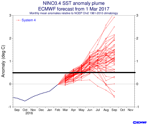
Ryan Maue is confused about the ECMWF forecast.
https://twitter.com/RyanMaue/status/853758338370330624
https://twitter.com/RyanMaue/status/853758338370330624
0 likes
Visit the Caribbean-Central America Weather Thread where you can find at first post web cams,radars
and observations from Caribbean basin members Click Here
and observations from Caribbean basin members Click Here
-
Kingarabian
- S2K Supporter
- Posts: 16361
- Joined: Sat Aug 08, 2009 3:06 am
- Location: Honolulu, Hawaii
Re: ENSO Updates
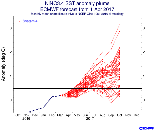
Tanking SOI, active WWB, and a warm PDO means that an El Nino is definitely in play. The only short term problem is the small cool pool. But if the WWB continues for as long as the GFS and Euro are showing, the effects of the cold pool should be warded off.
2 likes
RIP Kobe Bryant
-
weathaguyry
- Category 5
- Posts: 1273
- Age: 22
- Joined: Wed Jun 15, 2016 5:16 am
- Location: Long Island, NY
Re: ENSO Updates
Kingarabian wrote:Tanking SOI, active WWB, and a warm PDO means that an El Nino is definitely in play. The only short term problem is the small cool pool. But if the WWB continues for as long as the GFS and Euro are showing, the effects of the cold pool should be warded off.
Very interesting, It will be fascinating to see just how the water will react to the pattern shift, but the "cool pool" around 160W has become a bit larger and somewhat colder in the last few days, and the water in the subsurface around 180 is not very warm, so we shall see what happens with all of that, looking back, it is hard to find a good analog for this year, considering the atmosphere is pointing to an El-Nino yet the water is staying very neutral. Plus, didn't the models overdo the WWB lately?
0 likes
My posts are only my opinions and NOT official forecasts. For official forecasts, consult the National Hurricane Center or the National Weather Service.
Irene 11', Sandy 12', Fay 20’, Isaias 20’, Elsa 21’, Henri 21’, Ida 21’
Irene 11', Sandy 12', Fay 20’, Isaias 20’, Elsa 21’, Henri 21’, Ida 21’
Who is online
Users browsing this forum: No registered users and 228 guests