Alyono wrote:could those types of anomalies bring la niña into play?
I don't think a La Nina will form, but now the chance opens up for a straight up neutral event as opposed to a warm-neutral/borderline El Nino
Moderator: S2k Moderators


Alyono wrote:could those types of anomalies bring la niña into play?


weathaguyry wrote:Kingarabian wrote:[ig]http://www.cpc.ncep.noaa.gov/products/analysis_monitoring/ocean/anim/wkxzteq_anm.gif[/img]
Latest subsurface frame from May 13th shows that the warm pool continues to rapidly make up for lost ground in early Spring (thanks to those recent WWB's) . Ocean looks really welcoming for an El-Nino all of a sudden. That once solid cold pool @ 140W in March/April is disappearing fast as if it was never there.
In regards to the winds, the SOI should be switching back to a negative state soon. If I were a betting man, I wouldn't put money on more trades after this current burst.
If the trade surge forms like the models say it will, I wouldn't be surprised to see another cold pool form near and right under the surface at 180.

Hammy wrote:Are we pretty much looking at a 50/50 chance of El Nino at this point?


Hammy wrote:Are we pretty much looking at a 50/50 chance of El Nino at this point?
weathaguyry wrote:Wow, with the 30 day SOI average coming in above -6, and with this new trade surge forecasted by the ECMWF, I really think that the chances of an El Nino are quickly fading. I agree that there is a chance that we could have a borderline Nino for the ASO timeframe, but I honestly think it's too little, too late, because even though the warm pool in the subsurface is extensive to some degree, the "bullseye" of it is at 150m deep and still back at the dateline, if Nino was truly on the brink of getting going, I would think that there would be a nice subsurface stream of +1-2 C waters stretching throughout the subsurface under 120W-160W.
weathaguyry wrote:Wow, with the 30 day SOI average coming in above -6, and with this new trade surge forecasted by the ECMWF, I really think that the chances of an El Nino are quickly fading. I agree that there is a chance that we could have a borderline Nino for the ASO timeframe, but I honestly think it's too little, too late, because even though the warm pool in the subsurface is extensive to some degree, the "bullseye" of it is at 150m deep and still back at the dateline, if Nino was truly on the brink of getting going, I would think that there would be a nice subsurface stream of +1-2 C waters stretching throughout the subsurface under 120W-160W.
Hammy wrote:weathaguyry wrote:Wow, with the 30 day SOI average coming in above -6, and with this new trade surge forecasted by the ECMWF, I really think that the chances of an El Nino are quickly fading. I agree that there is a chance that we could have a borderline Nino for the ASO timeframe, but I honestly think it's too little, too late, because even though the warm pool in the subsurface is extensive to some degree, the "bullseye" of it is at 150m deep and still back at the dateline, if Nino was truly on the brink of getting going, I would think that there would be a nice subsurface stream of +1-2 C waters stretching throughout the subsurface under 120W-160W.
Given where the warm subsurface temps are, I think this points to a Modoki event should an El Nino materialize to start with.
tarheelprogrammer wrote:cycloneye wrote:The trade winds for days.
That should help push El Nino along right?
RL3AO wrote:tarheelprogrammer wrote:cycloneye wrote:The trade winds for days.
That should help push El Nino along right?
Stronger trade winds (negative zonal flow values) -> more upwelling -> Opposite of leading to El Nino.


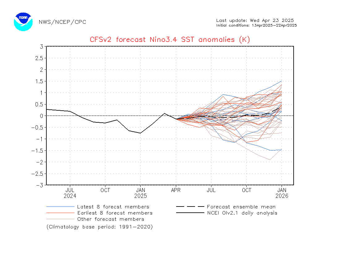


GeneratorPower wrote:The trend being my friend and all, I think we have an upcoming La Nada.
Ntxw wrote:GeneratorPower wrote:The trend being my friend and all, I think we have an upcoming La Nada.
Thus far El Neutral warm ENSO. Still haven't seen the weeklies dip below 0.5C yet
Users browsing this forum: Google Adsense [Bot] and 250 guests


