Central Atlantic / Eastern Atlantic

This is the general tropical discussion area. Anyone can take their shot at predicting a storms path.

Moderator: S2k Moderators

Forum rules

The posts in this forum are NOT official forecasts and should not be used as such. They are just the opinion of the poster and may or may not be backed by sound meteorological data. They are NOT endorsed by any professional institution or STORM2K. For official information, please refer to products from the National Hurricane Center and National Weather Service.

Help Support Storm2K
Message
Author
User avatar
Gustywind
Category 5
Category 5
Posts: 12334
Joined: Mon Sep 03, 2007 7:29 am
Location: Baie-Mahault, GUADELOUPE

#81 Postby Gustywind » Tue May 20, 2008 6:53 pm

Absolutely Opal Storm, i tkink the same as my previous posts:"
Be calm, no TD will arrive right now , we have time for that... my friends don't worry about, things will change a little bit in less than two months only one thing to do: tighten your teeths "lol
Wait and see more than decents waves, more organized with more conducive conditions , and after that we wil see what really happens for this season
8-) ;
0 likes   

RL3AO
Moderator-Pro Met
Moderator-Pro Met
Posts: 16308
Joined: Thu Jun 14, 2007 10:03 pm
Location: NC

#82 Postby RL3AO » Tue May 20, 2008 6:55 pm

I'm wondering why that convection is so far north.
0 likes   

User avatar
Gustywind
Category 5
Category 5
Posts: 12334
Joined: Mon Sep 03, 2007 7:29 am
Location: Baie-Mahault, GUADELOUPE

#83 Postby Gustywind » Tue May 20, 2008 7:15 pm

Maybe the High pressure on this region is more to the north, working in tandem in theory with the ITCZ.... keeping the ITCZ more norther, and "placing" the waves more to the north ...in my humble opinion. 8-). If somebody can help us, answers and thoughts are welcomed :D
0 likes   

User avatar
Category 5
Category 5
Category 5
Posts: 10074
Age: 35
Joined: Sun Feb 11, 2007 10:00 pm
Location: New Brunswick, NJ
Contact:

Re: Central Atlantic / Coast of Africa

#84 Postby Category 5 » Tue May 20, 2008 9:23 pm

Opal storm wrote:Way too early to be looking this far out for anything, but these waves give us a good indication that the season is about to get rollin'.


Waves like this though can become tropical systems if they make it to the Caribbean or GOM. The wave the produced Allison exited Africa on may 21st. This seems to be quite uncommon though, since Allison was the only example I could find for now. I'm sure it's happened before, but I wouldn't bet a penny on it happening here.
0 likes   

User avatar
Marilyn
Tropical Storm
Tropical Storm
Posts: 232
Joined: Mon Aug 08, 2005 9:36 am
Location: white oak, NC

#85 Postby Marilyn » Tue May 20, 2008 10:04 pm

Welcome Lena :D
0 likes   

User avatar
Gustywind
Category 5
Category 5
Posts: 12334
Joined: Mon Sep 03, 2007 7:29 am
Location: Baie-Mahault, GUADELOUPE

#86 Postby Gustywind » Wed May 21, 2008 6:03 am

Atlantic Tropical Weather Discussion
--------------------------------------------------------------------------------


000
AXNT20 KNHC 211025
TWDAT

TROPICAL WEATHER DISCUSSION
NWS TPC/NATIONAL HURRICANE CENTER MIAMI FL
805 AM EDT WED MAY 21 2008

TROPICAL WEATHER DISCUSSION FOR NORTH AMERICA...CENTRAL
AMERICA...THE GULF OF MEXICO...THE CARIBBEAN SEA...NORTHERN
SECTIONS OF SOUTH AMERICA...AND THE ATLANTIC OCEAN TO THE
AFRICAN COAST FROM THE EQUATOR TO 32N. THE FOLLOWING
INFORMATION IS BASED ON SATELLITE IMAGERY...METEOROLOGICAL
ANALYSIS...WEATHER OBSERVATIONS...AND RADAR.

BASED ON 0600 UTC SURFACE ANALYSIS AND SATELLITE IMAGERY THROUGH
0945 UTC.

...TROPICAL WAVES...
TROPICAL WAVE IS ALONG 20W S OF 12N MOVING W 10 KT. MIMIC TPW
ANIMATION SHOWS THE POSSIBLE MOISTURE ASSOCIATED WITH A TROPICAL
WAVE BUT THE SATELLITE IMAGERY SHOWS A MID LEVEL ROTATION NEAR
7N18W. ANY CONVECTION IS 3WITHIN THE ITCZ.
0 likes   

User avatar
drezee
S2K Supporter
S2K Supporter
Posts: 3664
Joined: Mon Jun 09, 2003 12:49 pm
Location: FL

Re: Central Atlantic / Coast of Africa

#87 Postby drezee » Fri May 23, 2008 8:31 am

Still there:

TROPICAL WAVE IS ALONG 26W/27W S OF 12N MOVING W 10-15 KT. WELL
DEFINED MID LEVEL ROTATION IS ALONG THE AXIS NEAR 6N. AREA OF
DENSE CLOUDS WITH SCATTERED SHOWERS/ISOLATED THUNDERSTORMS FROM
3N-9N BETWEEN WAVE AXIS AND 30W.


Looks great on the visible sat loops this AM...
0 likes   

User avatar
HURAKAN
Professional-Met
Professional-Met
Posts: 46086
Age: 38
Joined: Thu May 20, 2004 4:34 pm
Location: Key West, FL
Contact:

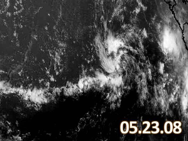
#88 Postby HURAKAN » Fri May 23, 2008 8:52 am

Image

Nice looking TW.
0 likes   

User avatar
KWT
Category 5
Category 5
Posts: 31415
Joined: Tue Aug 17, 2004 11:02 am
Location: UK!!!

#89 Postby KWT » Fri May 23, 2008 8:57 am

Yep thats quite a sharp wave at that as well. Of course convection isn't all that impressive but at this time of year its a pretty decent looking wave...if this was August we'd have to watch these sorts of waves really closely.
0 likes   

User avatar
bvigal
S2K Supporter
S2K Supporter
Posts: 2276
Joined: Sun Jul 24, 2005 8:49 am
Location: British Virgin Islands
Contact:

Re: Central Atlantic / Coast of Africa

#90 Postby bvigal » Fri May 23, 2008 11:51 am

That healthy-looking wave has now (12z surface) been labeled a 1010mb low. Not the usual fare for May.
http://www.opc.ncep.noaa.gov/UA/Atl_Tropics.gif
0 likes   

RL3AO
Moderator-Pro Met
Moderator-Pro Met
Posts: 16308
Joined: Thu Jun 14, 2007 10:03 pm
Location: NC

#91 Postby RL3AO » Fri May 23, 2008 12:15 pm

Isn't that the first wave to get tagged with a low in the Atlantic this year?
0 likes   

User avatar
killah
Tropical Low
Tropical Low
Posts: 29
Joined: Fri Aug 26, 2005 1:03 am

Re: Central Atlantic / Coast of Africa

#92 Postby killah » Fri May 23, 2008 12:24 pm

Wow, I thought it was too early for this. It still might have a hard time developing into something organzied, we shall see.
0 likes   

RL3AO
Moderator-Pro Met
Moderator-Pro Met
Posts: 16308
Joined: Thu Jun 14, 2007 10:03 pm
Location: NC

#93 Postby RL3AO » Fri May 23, 2008 12:26 pm

It was in an area of 15 kts. Now its moving into an area of 30+ kts shear.
0 likes   

User avatar
cycloneye
Admin
Admin
Posts: 145330
Age: 68
Joined: Thu Oct 10, 2002 10:54 am
Location: San Juan, Puerto Rico

Re: Central Atlantic / Coast of Africa

#94 Postby cycloneye » Fri May 23, 2008 12:34 pm

Maybe,this wave may be the one that GFS develop in the Western Caribbean when it reaches that area.
0 likes   

User avatar
masaji79
Tropical Storm
Tropical Storm
Posts: 183
Joined: Sun Dec 02, 2007 12:36 am
Location: Las Vegas, Nevada

Re: Central Atlantic / Coast of Africa

#95 Postby masaji79 » Fri May 23, 2008 12:56 pm

Looks like the wave has some pronounced turning. Probably too early in the season for anything to develop way out here, but still cool to watch.

http://www.ssd.noaa.gov/PS/TROP/DATA/RT/EATL/VIS/20.jpg
0 likes   

User avatar
cycloneye
Admin
Admin
Posts: 145330
Age: 68
Joined: Thu Oct 10, 2002 10:54 am
Location: San Juan, Puerto Rico

Re: Central Atlantic / Coast of Africa

#96 Postby cycloneye » Fri May 23, 2008 1:03 pm

2:05 PM Discussion by TPC:

A WELL DEFINED TROPICAL WAVE IS ALONG 27W/28W S OF 13N MOVING W
10-15 KT. A 1010 MB LOW WAS ADDED ALONG THE WAVE AXIS NEAR 6N...
BASED ON PRONOUNCED LOW-LEVEL TURNING APPARENT ON VISIBLE IMAGES
AND A FAIR AMOUNT OF CURVATURE IN AN EARLIER QSCAT PASS...
DESPITE MUCH RAIN FLAGGING. CONVECTION IS CONFINED TO AN AREA N
OF THE LOW CENTER FROM 7N-9N BETWEEN 26W-29W.

http://www.storm2k.org/weather/hw3.php? ... hwvmetric=
0 likes   

RL3AO
Moderator-Pro Met
Moderator-Pro Met
Posts: 16308
Joined: Thu Jun 14, 2007 10:03 pm
Location: NC

#97 Postby RL3AO » Fri May 23, 2008 1:05 pm

You beat me to it cycloneeye.
0 likes   

User avatar
cycloneye
Admin
Admin
Posts: 145330
Age: 68
Joined: Thu Oct 10, 2002 10:54 am
Location: San Juan, Puerto Rico

Re: Central Atlantic / Coast of Africa

#98 Postby cycloneye » Fri May 23, 2008 1:17 pm

Image

Image

Are we looking at the first invest of 2008 for the Atlantic?
0 likes   

User avatar
HURAKAN
Professional-Met
Professional-Met
Posts: 46086
Age: 38
Joined: Thu May 20, 2004 4:34 pm
Location: Key West, FL
Contact:

#99 Postby HURAKAN » Fri May 23, 2008 2:04 pm

Image

There is a smell of "poof" in the air!!!
0 likes   

RL3AO
Moderator-Pro Met
Moderator-Pro Met
Posts: 16308
Joined: Thu Jun 14, 2007 10:03 pm
Location: NC

#100 Postby RL3AO » Fri May 23, 2008 2:08 pm

It was in an area of low shear. Its entering an area of high shear. No chance at an invest.
0 likes   


Return to “Talkin' Tropics”

Who is online

Users browsing this forum: southmdwatcher, Steve H. and 52 guests