The posts in this forum are NOT official forecast and should not be used as such. They are just the opinion of the poster and may or may not be backed by sound meteorological data. They are NOT endorsed by any professional institution or storm2k.org. For official information, please refer to the NHC and NWS products.
Area Of Disturbed Weather In NW Caribbean (Is Invest 96L)
Moderator: S2k Moderators
Forum rules

The posts in this forum are NOT official forecasts and should not be used as such. They are just the opinion of the poster and may or may not be backed by sound meteorological data. They are NOT endorsed by any professional institution or STORM2K. For official information, please refer to products from the National Hurricane Center and National Weather Service.
-
Evil Jeremy

- S2K Supporter

- Posts: 5463
- Age: 32
- Joined: Mon Apr 10, 2006 2:10 pm
- Location: Los Angeles, CA
Re: Area Of Disturbed Weather In NW Caribbean.
I also believe that this will be our next invest, as early as today as we now have a floater on it. I have been watching the models, an while none of the globals are really showing devlopment at this time, they do show a monster ridge building back in over the Atlantic and GOM that could keep this down in the Bay of Honduras for a while.
0 likes
-
gatorcane

- S2K Supporter
- Posts: 23708
- Age: 48
- Joined: Sun Mar 13, 2005 3:54 pm
- Location: Boca Raton, FL
Re: Area Of Disturbed Weather In NW Caribbean.
Evil Jeremy wrote:I also believe that this will be our next invest, as early as today as we now have a floater on it. I have been watching the models, an while none of the globals are really showing devlopment at this time, they do show a monster ridge building back in over the Atlantic and GOM that could keep this down in the Bay of Honduras for a while.The posts in this forum are NOT official forecast and should not be used as such. They are just the opinion of the poster and may or may not be backed by sound meteorological data. They are NOT endorsed by any professional institution or storm2k.org. For official information, please refer to the NHC and NWS products.
Yes here is the 06Z projection 6 hours from 06Z and here we have the 500MB wind-flow (wind-flow at the mid-levels) showing that Canadian Low and the big trough over the East Coast and Southern GOM.

By 48 hours, look at the ridge that builds in all the way from the Western Atlantic into the Southern GOM. That should keep anything in the NW Caribbean from moving much for the next couple of days:

That ridging over the GOM holds for several more days and then a cut-off low is expected to swing down from a short-wave passing through the plains by 120 hours or so. Here we have 126 hours:

and finally we have 144 hours showing the cut-off low moving through the SE US:

That would cause whatever forms in the NW Caribbean to eventually move off to the NE through Southern Florida or Cuba/Bahamas, a typical path for an October system if it develops.
0 likes
-
HURAKAN

- Professional-Met

- Posts: 46084
- Age: 39
- Joined: Thu May 20, 2004 4:34 pm
- Location: Key West, FL
- Contact:
The NHC has been keeping an eye on this system for sometime as an internal invest:
BEGIN
NHC
invest_al852008.invest
FSTDA
R
U
040
010
0000
200810022112
NONE
NOTIFY=ATRP
END
NONAME, AL, L, , , , , 85, 2008, TD, O, 2008100218, 9999999999, , , , , , METWATCH, , AL852008
AL, 85, 2008100118, , BEST, 0, 147N, 861W, 15, 1011, DB, 0, , 0, 0, 0, 0,
AL, 85, 2008100200, , BEST, 0, 151N, 858W, 15, 1011, DB, 0, , 0, 0, 0, 0,
AL, 85, 2008100206, , BEST, 0, 155N, 856W, 20, 1010, DB, 0, , 0, 0, 0, 0,
AL, 85, 2008100212, , BEST, 0, 159N, 855W, 20, 1010, DB, 0, , 0, 0, 0, 0,
AL, 85, 2008100218, , BEST, 0, 162N, 855W, 20, 1009, TD, 34, NEQ, 0, 0, 0, 0, 1011, 170, 50, 0, 0, L, 0, , 0, 0, NONAME, D,
When they use invests in the range of the 80s, they are for exercise. Many times they become real invests.
0 likes
-
gatorcane
- S2K Supporter
- Posts: 23708
- Age: 48
- Joined: Sun Mar 13, 2005 3:54 pm
- Location: Boca Raton, FL
Here is the link to keep checking. When this area becomes an invest, this webpage will show it:
http://www.nrlmry.navy.mil/tc_pages/tc_home.html
http://www.nrlmry.navy.mil/tc_pages/tc_home.html
Last edited by gatorcane on Fri Oct 03, 2008 8:38 am, edited 2 times in total.
0 likes
-
Ed Mahmoud
Re:
HURAKAN wrote:The NHC has been keeping an eye on this system for sometime as an internal invest:
BEGIN
NHC
invest_al852008.invest
FSTDA
R
U
040
010
0000
200810022112
NONE
NOTIFY=ATRP
END
NONAME, AL, L, , , , , 85, 2008, TD, O, 2008100218, 9999999999, , , , , , METWATCH, , AL852008
AL, 85, 2008100118, , BEST, 0, 147N, 861W, 15, 1011, DB, 0, , 0, 0, 0, 0,
AL, 85, 2008100200, , BEST, 0, 151N, 858W, 15, 1011, DB, 0, , 0, 0, 0, 0,
AL, 85, 2008100206, , BEST, 0, 155N, 856W, 20, 1010, DB, 0, , 0, 0, 0, 0,
AL, 85, 2008100212, , BEST, 0, 159N, 855W, 20, 1010, DB, 0, , 0, 0, 0, 0,
AL, 85, 2008100218, , BEST, 0, 162N, 855W, 20, 1009, TD, 34, NEQ, 0, 0, 0, 0, 1011, 170, 50, 0, 0, L, 0, , 0, 0, NONAME, D,
When they use invests in the range of the 80s, they are for exercise. Many times they become real invests.
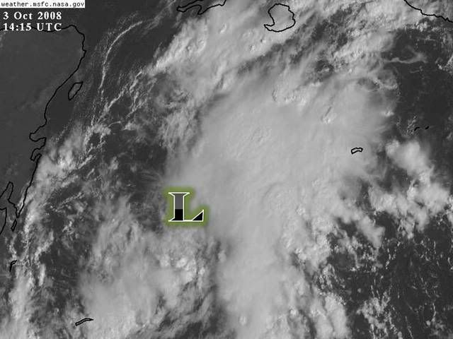
It has a floater...
0 likes

-
gatorcane
- S2K Supporter
- Posts: 23708
- Age: 48
- Joined: Sun Mar 13, 2005 3:54 pm
- Location: Boca Raton, FL
Pressures at Buoy 42056 (located at 19.874 N 85.059 W (19°52'27" N 85°3'33" W))
continue to slowly fall:
http://www.ndbc.noaa.gov/show_plot.php? ... _label=GMT
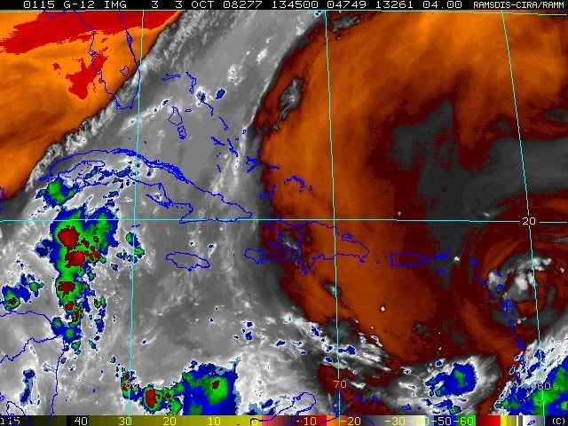
Also looking at the image above, the lowest pressure seems to be on the west side of the deeper convection that has formed over the past few hours (not underneath the blob)
continue to slowly fall:
http://www.ndbc.noaa.gov/show_plot.php? ... _label=GMT
Also looking at the image above, the lowest pressure seems to be on the west side of the deeper convection that has formed over the past few hours (not underneath the blob)
0 likes
Re: Area Of Disturbed Weather In NW Caribbean.
There's the burst it needed to form. You can tell it is still weak because the burst is along a linear wave axis. However the surface flow on the SE side suggests the center will form under that convection.
Right now the frontal boundary is in slight regression so the ultimate path of any tropical system should be N or so. If it went right up the front now it would probably be NE and east of Florida.
Looks like show time on this wave.
Right now the frontal boundary is in slight regression so the ultimate path of any tropical system should be N or so. If it went right up the front now it would probably be NE and east of Florida.
Looks like show time on this wave.
0 likes

Re: Area Of Disturbed Weather In NW Caribbean.
Seems to be at least a mid-level center near 18.5N-84.5W. With the deep convection, climatology, and CC spin - this looks like our next INVEST. Should happen today.
http://www.ssd.noaa.gov/goes/flt/t1/sloop-vis.html
http://www.ssd.noaa.gov/goes/flt/t1/sloop-vis.html
0 likes
-
Evil Jeremy
- S2K Supporter
- Posts: 5463
- Age: 32
- Joined: Mon Apr 10, 2006 2:10 pm
- Location: Los Angeles, CA
-
Typhoon_Willie

- Category 5

- Posts: 1042
- Joined: Mon Jun 09, 2003 3:19 pm
- Location: Greenacres City, Florida
Re: Area Of Disturbed Weather In NW Caribbean.
The Hurricane Center has a floater on the system with the term invest mentioned on it. Should be interesting...
0 likes
-
DESTRUCTION5

- Category 5
- Posts: 4430
- Age: 44
- Joined: Wed Sep 03, 2003 11:25 am
- Location: Stuart, FL

Re: Area Of Disturbed Weather In NW Caribbean.
I don't see much as of yet, but some mid level eddies from collapsing T-storms. Still looks like a trough in the lower levels but I still would not be surprised to see some development tomorrow.
0 likes
-
Ed Mahmoud
Re: Area Of Disturbed Weather In NW Caribbean.
West wind, 10 mph, at La Ceiba in Honduras, but I don't know enough about the local weather to say if that is some kind of local microscale effect, like a sea-breeze or something like that.
The 1013 mb is actually the highest the pressure has been today.
ETA: Roatan is calm, pressure has also risen past few hours to 1013 mb.
The 1013 mb is actually the highest the pressure has been today.
Wind from the W (260 degrees) at 10 MPH (9 KT)
Visibility greater than 7 mile(s)
Sky conditions mostly cloudy
Weather Cumulonimbus clouds, towering cumulus clouds observed
Temperature 82 F (28 C)
Dew Point 73 F (23 C)
Relative Humidity 74%
Pressure (altimeter) 29.91 in. Hg (1013 hPa)
ob MHLC 031600Z 26009KT 9999 SCT024CB SCT080 BKN200 28/23 Q1013 CB NNE TCU W HZ NOSIG
--------------------------------------------------------------------------------
ETA: Roatan is calm, pressure has also risen past few hours to 1013 mb.
0 likes
-
gatorcane
- S2K Supporter
- Posts: 23708
- Age: 48
- Joined: Sun Mar 13, 2005 3:54 pm
- Location: Boca Raton, FL
I would expect something like this from the NHC within the next couple of TWOs.
"showers and thunderstorms have increased with an area of low pressure across the NW Caribbean Sea....while conditions are only marginally favorable for development, conditions could become more favorable for development over the next couple of days as the system moves little."
code yellow still for today.
0 likes
Who is online
Users browsing this forum: No registered users and 190 guests